#GeoSpatialData
Explore tagged Tumblr posts
Visit Tumblr Blog
Explore Tumblr blogs with no restrictions, modern design and the best experience.
Last Seen Tumblr Blogs


Fun Fact
Tumblr has 4 main sources of revenue.
Text
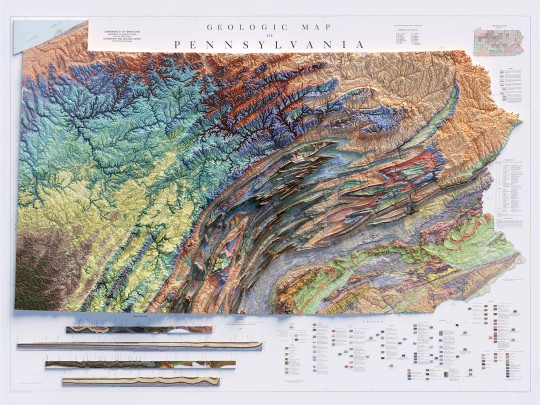
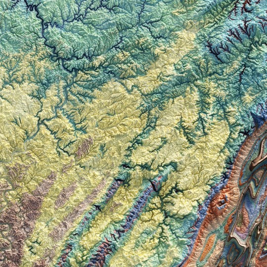
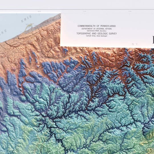

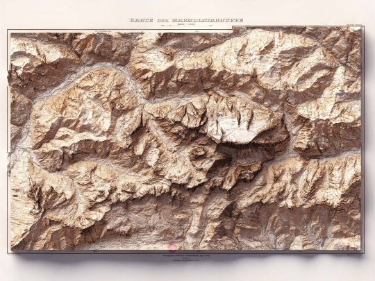
From the 1960s, a (restored) school geological map of Pennsylvania, obviously with shaded relief!
🗺️ 𝗠𝗔𝗣 𝗜𝗡𝗙𝗢 Geologic map of Pennsylvania, Topographic and Geologic Survey, Commonwealth of PA, 1960. Source: David Rumsey Collection.
If you like our work, want to see our daily updates (or want to say hello to our studio), consider to follow our Instagram or Twitter account. Otherwise if are interested in our prints or have a custom request check our shop.
#Pennsylvania#pittsburgh#usmap#mapdesign#GeologyPA#VintageMap#PennsylvaniaHistory#ShadedRelief#GeologicHeritage#PAExploration#RockFormation#GeologicalTreasure#EarthScience#PennsylvaniaGeology#GeologicWonders#LandscapeHistory#GeologicalArt#ElevationData#GeologicMapping#BedrockGeology#NaturalHistory#GeospatialData#GeologicFeatures#MapArt#vizart
4 notes
·
View notes
Text
Overcoming Mobile Mapping Challenges in Transportation: Expert Strategies & Solutions
Introduction
Mobile mapping plays a crucial role in transportation projects, enabling accurate data collection and analysis. However, challenges such as data accuracy, processing inefficiencies, and integration complexities can hinder project success. In this blog, we’ll explore expert strategies and solutions to overcome these challenges, with a focus on leveraging photogrammetry software to enhance mobile mapping workflows.
Leverage Advanced Photogrammetry Software for Accurate Data Capture
One of the most significant hurdles in mobile mapping is ensuring accurate, high-quality data collection. Advanced photogrammetry software provides a powerful solution by converting aerial imagery into precise 3D models and point clouds.
Photogrammetry software enables the processing of drone imagery to generate detailed geospatial data.
Features like automatic image matching, bundle adjustment, and dense point cloud generation enhance mapping accuracy.
Selecting the right software improves both efficiency and data precision, reducing errors in transportation project planning.
Beyond just software, successful mobile mapping also requires:
High-quality drones and cameras for superior image capture.
Proper training of field crews on data collection best practices.
Standardized data validation processes to ensure consistency and reliability.
By combining photogrammetry software with structured workflows, transportation projects can significantly enhance mapping accuracy and efficiency.
Implement Automated Georeferencing for Efficient Data Processing
After data collection, the next challenge is processing vast amounts of mobile mapping data. Automated georeferencing streamlines this phase by precisely aligning and positioning datasets within their geographic context.
Eliminates manual tie point selection, reducing processing time.
Enhances the efficiency of photogrammetry software by ensuring seamless spatial alignment.
Reduces human error, improving overall mapping accuracy.
By integrating automated georeferencing into photogrammetry software workflows, teams can accelerate data processing and focus on actionable insights for better decision-making in transportation projects.
Utilize 4D Capabilities for Comprehensive Project Monitoring
Transportation projects are dynamic, evolving over time. Traditional 2D and 3D mapping may not capture the full picture, but 4D capabilities—incorporating the time dimension—offer deeper insights.
Photogrammetry software with 4D capabilities enables visualization of project progress over time.
It helps detect trends, patterns, and potential bottlenecks before they become critical issues.
Enhances decision-making by providing real-time insights into project developments.
Implementing 4D mapping ensures continuous project monitoring, allowing transportation planners to optimize resources and minimize delays.
Integrate with Construction Management Software for Seamless Workflows
To maximize the benefits of mobile mapping, transportation projects must integrate their geospatial data with existing construction management systems. This integration:
Centralizes project data for easy access and analysis.
Enables real-time updates across teams and systems.
Enhances collaboration by ensuring all stakeholders work with the latest data.
Reduces errors and inefficiencies, streamlining project execution.
By embedding photogrammetry software data into construction management platforms, organizations create a seamless, end-to-end workflow that improves efficiency and project outcomes.
Collaborate with Expert Partners for Optimized Mobile Mapping
Mobile mapping success requires more than just technology—it demands expertise. Collaborating with industry leaders helps organizations leverage best practices and innovative solutions.
Photogrammetry software providers offer specialized tools and training for improved data processing.
Partnering with experts in aerial imaging and geospatial analytics ensures high-quality results.
Proven industry partnerships accelerate implementation and enhance project scalability.
Selecting experienced partners with deep knowledge of this software and mobile mapping technologies guarantees optimized workflows and successful transportation project execution.
Conclusion
Overcoming mobile mapping challenges in transportation requires a combination of advanced photogrammetry software, automated georeferencing, 4D monitoring, system integration, and expert collaboration. By implementing these strategies, organizations can improve data accuracy, streamline workflows, and enhance decision-making for transportation projects.
Ready to transform your mobile mapping processes? Discover how Magnasoft's advanced geospatial solutions can help optimize transportation projects. Contact us today to learn more.
0 notes
Text
The Ultimate QGIS 3 Guide – Learn GIS Mapping & Automation
Unlock the secrets of QGIS 3 with this in-depth Udemy course! 📌 Learn GIS workflows, mapping techniques & data visualization.
🌍 ONLY $12.99 from $19.99 (48% off)!
#QGISGuide#GISAutomation#LearnMapping#DataScienceMapping#GeospatialData#GISDevelopment#QGISTools#RemoteSensingGIS#GISAnalysis#MappingExperts
0 notes
Text
Exploring (NYSE:PL) Role in Space-Based Data Solutions
Planet Labs PBC (NYSE:PL) specializes in satellite imagery and geospatial data, providing insights for industries such as agriculture, defense, and environmental monitoring. With a vast satellite network, the company delivers real-time earth observation solutions, supporting decision-making across multiple sectors. Its advancements in space technology enhance global data accessibility and efficiency.
0 notes
Text
Drone Land Survey: Revolutionizing Land Mapping with Precision and Efficiency

Introduction
In the world of land surveying, accuracy, efficiency, and safety are paramount. Traditional methods, while reliable, can be time-consuming, labor-intensive, and sometimes risky. Enter drone land surveys—a game-changing technology that is transforming the industry. Drones are now being used to conduct land surveys faster, more accurately, and at a fraction of the cost of traditional methods. In this blog, we’ll dive into what drone land surveys are, why they’re so effective, and how they can benefit your next project.
What is a Drone Land Survey?
A drone land survey involves using unmanned aerial vehicles (UAVs) equipped with high-resolution cameras, LiDAR sensors, and GPS technology to capture detailed aerial data of a piece of land. This data is then processed using specialized software to create accurate maps, 3D models, and topographic surveys. Drone land surveys are used in a variety of industries, including construction, agriculture, mining, and urban planning.
Why Drone Land Surveys Are a Game-Changer
Unmatched Speed Drones can cover large areas of land in a matter of minutes or hours, compared to the days or weeks it might take using traditional ground-based methods. This makes them ideal for time-sensitive projects.
Cost-Effective By reducing the need for heavy equipment, large teams, and extended fieldwork, drone surveys significantly lower costs. They also minimize the risk of human error, which can be expensive to correct.
High Precision Modern drones are equipped with advanced sensors and GPS technology, allowing them to capture data with centimeter-level accuracy. This level of precision is essential for creating detailed topographic maps and 3D models.
Enhanced Safety Drones can access difficult or hazardous terrain, such as steep slopes, unstable ground, or disaster zones, without putting surveyors at risk.
Versatility Drone land surveys can be used for a wide range of applications, from measuring land boundaries to monitoring construction progress and assessing environmental changes.
How Drone Land Surveys Work
Planning the Survey Before the drone takes off, the survey area is mapped out using specialized software. This ensures that the drone captures all necessary data efficiently.
Data Collection The drone is equipped with cameras and sensors that capture high-resolution images, elevation data, and other relevant information as it flies over the land.
Data Processing The collected data is processed using photogrammetry or LiDAR software to create detailed maps, 3D models, or contour lines. This step often involves stitching together hundreds or thousands of images to form a cohesive model.
Analysis and Reporting The final output is analyzed and presented in a format that meets the project’s requirements, whether it’s a topographic map, volumetric analysis, or a detailed 3D rendering.
Applications of Drone Land Surveys
Construction Drones are used to monitor construction progress, track stockpile volumes, and create as-built surveys.
Agriculture Farmers use drone surveys to assess crop health, plan irrigation systems, and optimize land use.
Mining Drones help in calculating stockpile volumes, monitoring mine sites, and ensuring compliance with safety regulations.
Environmental Monitoring Conservationists use drones to map forests, monitor wildlife, and assess the impact of natural disasters.
Urban Planning City planners rely on drone surveys to create detailed maps for infrastructure development and zoning.
Choosing the Right Drone for Land Surveys
When selecting a drone for land surveys, consider the following factors:
Payload Capacity: Ensure the drone can carry the necessary cameras and sensors.
Flight Time: Longer flight times allow for larger areas to be covered in a single mission.
GPS Accuracy: High-precision GPS is essential for accurate data collection.
Software Compatibility: The drone should be compatible with industry-standard mapping software.
Popular drones for land surveying include the DJI Phantom 4 RTK, senseFly eBee X, and WingtraOne.
The Future of Drone Land Surveys
As technology continues to advance, the capabilities of drone land surveys are only expected to grow. Innovations like AI-powered data analysis, real-time mapping, and improved battery life will make drones even more efficient and accessible. Additionally, the integration of drones with other technologies, such as augmented reality (AR) and the Internet of Things (IoT), will open up new possibilities for industries worldwide.
Conclusion
Drone land surveys are revolutionizing the way we collect and analyze spatial data. With their unmatched speed, accuracy, and versatility, drones are becoming an indispensable tool for professionals across various fields. Whether you’re a land surveyor, a farmer, or a construction manager, incorporating drone technology into your workflow can save time, reduce costs, and improve the quality of your projects.
If you haven’t yet explored the potential of drone land surveys, now is the time to take flight. The sky’s the limit when it comes to what you can achieve with this cutting-edge technology!
Call to Action Ready to elevate your land surveying projects? Contact us today to learn more about how drone technology can benefit your business. Let’s map the future together!
#DroneLandSurvey#LandSurveying#AerialSurvey#GISMapping#DroneTechnology#PrecisionSurvey#GeospatialData#SurveyingSolutions#LandMapping#UAVSurveying#AccurateSurvey#DroneData#SurveyingInnovation#LandSurvey#DroneMapping
1 note
·
View note
Text
The Power of Surveys: Understanding Their Importance and Types
A survey is a method of collecting information by doing relevant research and using technology to analyze the data, and condition of a specific area or mapping out the construction area. This data is important for planning, designing, and constructing different projects. Dolphin Engineer understand the importance of surveys in various industries. The survey is an essential part of our service, we have been providing accurate reports and reliable results to our clients for over two decades. In this blog, we understand the importance of surveys and the different kinds of surveys we do.
Why survey are important?
Surveys provide researchers with reliable, usable, primary data to inform. They are important because the data comes directly from the individuals you have identified in your goal. Surveys give you a detailed, systematic way to view and analyze your data. Surveys play a major role in gathering data, opinions, and feedback from clients. Accurate survey data also helps avoid costly mistakes and rework, making the project more cost-efficient. Additionally, surveys ensure that projects comply with local, state, and federal regulations, preventing legal issues and fines.
Types of surveys we do-
Topographical Survey- Topographic Surveys are worn to recognize and map the shape of the ground and existing features on the plane of the earth or a little above or below the earth's surface (i.e. trees, buildings, streets, walkways, manholes, utility poles, retaining walls, etc.). This type of topographic survey can be very favorable to homeowners, industrial owners, or even for land under an edifice. Land may include hills, trees, fences, buildings, and ravines. If the purpose of the survey is to serve as a base map for the design of a residence or building of some type or design a road or driveway.

Water Supply Survey- A pipeline survey is the initial step in planning and installing a safe water, gas, or oil pipeline. Dolphin Survey Engineering provides a significant and lucrative alignment for pipe laying and prepares the necessary land accusation planning by Cadastral. Solar Power Plant Surveys- We conduct surveys for the installation of solar power stations. Solar power stations have a basic need to capture as ample sunlight available as possible. There are certain conditions where the resource is available in ample like deserts while some areas get the bare minimum of sunlight in certain parts of the year.
River Survey- Dolphin Engineering are expert in river surveys we have a group of professionals who perform their work in the best manner. River survey helps in analyzing the depth and width of the river and also helps in analyzing the flow of the waves. It helps to gather accurate information about the river. This survey helps in analyzing the temperature of the river. This survey includes two things cross-sections and contour maps.
Bathymetric Survey The bathymetric test helps in measuring the depth of the water body. This survey helps in gathering information regarding underwater and also helps in preparing the map. There are various techniques used to measure the depth. This survey helps in collecting accurate information about the sea.
Conclusion
Surveys are a powerful tool that can help organizations, governments, and individuals make informed decisions, identify trends, and understand public perspectives. Dolphin Engineer, we understand the importance of surveys and offer a range of survey services to our clients. Whether you need topographical surveys, River surveys, or Solar Power Plant surveys, we have the expertise and equipment to deliver accurate and reliable results.
Contact us today to learn more about our survey services and how we can help you achieve your goals.
#Surveying#Engineering#TopographicalSurvey#WaterSupplySurvey#SolarPowerSurvey#RiverSurvey#BathymetricSurvey#DolphinEngineer#DataAnalysis#ConstructionPlanning#AccurateReports#ReliableResults#CostEfficiency#RegulatoryCompliance#Mapping#ProjectDesign#SurveyServices#EngineeringServices#InfrastructurePlanning#GeospatialData
0 notes
Text
How to add Location in Google Maps | YMA PRO TECH
Open Google Maps, find the location, right-click (tap and hold on mobile) to drop a pin. Click the pin, select "Add a missing place," enter the name, category, address, and details. Adjust pin placement if needed. Add photos/videos. Review and submit. Wait for Google's verification process.
youtube
#GoogleMaps#AddLocation#NewPlaceOnMaps#MapUpdates#LocalBusiness#PlacesNearMe#MapContributions#MapEditing#UserGeneratedContent#CrowdsourcedMaps#LocalGuides#MapMaking#MapData#OpenStreetMap#CitizenCartography#DigitalMapping#GeoSpatialData#LocationBasedServices#MapYourWorld#MappingCommunity#MapEverything#GeoTags#PlaceMarkers#PinDropping#MapCollaborations#LocationSharing#CrowdsourcedPlaces#MapYourCity#Youtube
0 notes
Video
youtube
Space Tech for Weighing Trees | Nature IS | Episode 102 with Florian Reber
#youtube#carbon#geospatialtechnology#climatescience#carbonsequestration#aitraining#geospatialdata#forestconservation
0 notes
Text
Conference


Students of MBA Department along with Dr. Ritu Soryan (HOD MBA) and Prof. Dr. BMK Prasad, Director General, Dronacharya Group of Institutions, Greater Noida attended the "Strategic Workshop on GeoWwise Green Credits: India's Pioneering Initiative" held at India International Centre, New Delhi on 8th February, 2024. Dr. Yogita Shukla, CEO of the addGEO Foundation, warmly welcomed the students.
The aim of the conference is to delve into the nuances of how geospatial information and technology is fundamental to robust water resource management and help communities earn green credits.
#greencredits#geospatialtechnology#geospatialdata#regenerativeeconomy#technology#mbadepartment#students#college#engineeringcollege#g20#cbseboard#delhincr#aicte#aktu#topprivateengineeringcollegeingreaternoida#bestengineeringcollegeindelhincr#DronacharyaGroupofInstitutions#multipleplacement#greaternoida#uttarpradesh
1 note
·
View note
Text
Unlocking the Power of Location-Based Services: Your Ultimate Guide!
A location-based service (LBS) is a service provided by software for mobile device apps that requires information on the location of the mobile device. The application collects geodata, which are real-time data obtained by one or more monitoring technologies.
Technological advances and the rising availability of geolocation, GPS, and mobile data technologies have made LBS more sophisticated and accessible. This allows for the development of new and creative market applications and solutions. These elements will contribute to driving the market expansion. In addition, according to a research report by Astute Analytica, the Global Location-Based Services Market is likely to grow at a compound annual growth rate (CAGR) of 24.2% over the projection period from 2023 to 2031.
What are the various types and elements needed to run location-based services?
Push:
The application starts the location process when triggered or at daily intervals. The application then displays appropriate information to the user or device based on their geographic location. In this case, a user gets emailed an advertisement or discount after the application detects that he or she is close to a particular retail outlet.
Pull:
The application user begins the location-based service procedures. A user using a mobile map application, like Waze, to identify the nearest automated teller machine is an example of a query-based on-location service. Few services also allow users to look into concerts, restaurants, or athletic events and utilize apps like Yelp, or Google Maps.
The following four essential elements are necessary for location-based services to function:
An application that makes use of location-based services.
A geodata collection placement system.
A mobile network for data transmission or reception.
Analytics software that runs on an outside server to calculate and present relevant data to users based on their geographic location.
What technologies are utilized to track a person's location?
Based on the demand, mobile device hardware type, and available enabling technologies, various tracking mechanisms are frequently employed for location-based services:
GPS: The Global Positioning System is a network of satellites that exist only to assist in the location of objects on Earth. These satellites can be pinged by any device equipped with a GPS receiver (including various smartphones). This function enables the gadget to link up with a minimum of four satellites.
Wi-Fi: Wi-Fi location tracking differs from previous approaches. Usually, a device only links to one Wi-Fi network at a time, thus removing the chance of triangulation. Instead, IP addresses are used in this location tracking.
Each network has an actual IP address that informs the rest of the internet where it is so that data may be sent over the internet infrastructure appropriately. When a user's phone joins a Wi-Fi network, it combines with the physical IP address of that network, enabling location services to determine their current location.
Cellular technology: Cellular tracking functions similarly to GPS. User device links to cellular towers rather than satellites. In general, they'll be within the reach of at least two of the towers, allowing the system to utilize triangulation to pinpoint their location.
#LocationBasedServices#GeolocationTech#GPSNavigation#MobileApps#GeospatialData#ProximityMarketing#GeoTargeting#LocationAnalytics#GISTechnology#RealTimeLocation#GeoMarketing#Geofencing
1 note
·
View note
Text

Join the location-based services revolution! According to a report, the market is set to reach USD 39.2 billion by 2025, with a growth rate of 17.6% from 2020. Don't miss out on leveraging this technology for your business.
For more information,https://hirinfotech.com/digital-marketing/ or contact us at [email protected]
0 notes
Text
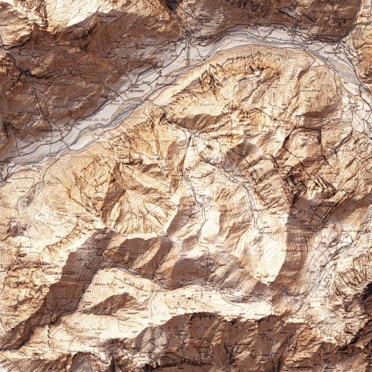
Today we show you the queen of the Dolomites: the Marmolada. The original map was made in 1926 by Freytag-Berndt. We restored it and gave it new life with shaded relief. If you like our work, want to see our daily updates (or want to say hello to our studio), consider to follow our Instagram or Twitter account. Otherwise if are interested in our prints or have a custom request check our shop.
#mountains#mountainlife#mountainlovers#dolomites#dolomitesunesco#dolomitesitaly#marmoladaglacier#marmolada#marmoladapassofedaia#cartography#cartographyart#mapart#digitalmaps#shadedrelief#geography#dataviz#geospatialdata#geospatial#gis#3dlandscape#vizart
3 notes
·
View notes
Text
The rapid evolution of deep technology is transforming geospatial mapping, pushing the boundaries of how spatial data is captured, processed, and utilized. AI, machine learning, blockchain, and cloud computing are making geospatial technology more intelligent, automated, and efficient. Among the biggest beneficiaries of this transformation are BIM modeling services and 3D BIM modeling, which leverage deep tech to enhance accuracy, efficiency, and decision-making across industries.
#DeepTech#GeospatialMapping#AIinGeospatial#BIM#3DBIMModeling#SmartCities#GeospatialData#MachineLearning#Blockchain
0 notes
Text
The Ultimate QGIS 3 Guide – Learn GIS Mapping & Automation!! Unlock the secrets of QGIS 3 with this in-depth Udemy course! 📌 Learn GIS workflows, mapping techniques & data visualization.
🌍 ONLY $12.99 from $19.99 (48% off)!
#QGISGuide#GISAutomation#LearnMapping#DataScienceMapping#GeospatialData#GISDevelopment#QGISTools#RemoteSensingGIS#GISAnalysis#MappingExperts
0 notes
Text
#aitools#ai#artificialintelligence#digitaltwin#indoormapping#newtech#geospatialdata#datamapping#gis#mapping#geospatialtechnology#gismapping#dmapping#geospatial#dmap#digitaltwins#machinelearning#lidar#onpassiveai#onpassive#assetmapping#maps#fieldmapping#aitechnology#dataextraction#earth#voxelmaps#utilitymapping#onpassiveaitools#dmodeling
0 notes
Text
Exploring the Power of Lidar Technology: Transforming Surveys and Mapping Solutions

In today’s fast-evolving world, lidar technology has emerged as one of the most groundbreaking tools for precise surveying services. Whether it's for aerial surveys, topographic surveys, or advanced mapping solutions, lidar offers exceptional accuracy and efficiency. Let’s explore how this cutting-edge technology is reshaping industries and driving innovation.
What is Lidar Technology?
Lidar technology stands for Light Detection and Ranging. It uses laser pulses to measure distances and create highly accurate 3D models of terrain, structures, and vegetation. When combined with remote sensing, lidar helps gather geospatial data quickly and safely, making it indispensable for various industries such as urban planning, environmental monitoring, and infrastructure development.
The Role of Aerial Surveys in Modern Mapping Solutions
Aerial surveys powered by lidar technology are one of the most effective ways to collect data over large areas. Drones and aircraft equipped with lidar sensors capture high-resolution data of landscapes, buildings, and other features in real-time. These surveys play a vital role in mapping solutions for everything from land development projects to flood risk assessment.
Unlike traditional methods that require time-consuming fieldwork, lidar offers a much faster, safer, and more accurate alternative. With lidar technology, businesses and governments can make more informed decisions while saving time and money.
Why Remote Sensing and Geospatial Data Matter
Remote sensing through lidar provides a unique advantage in collecting geospatial data from areas that are difficult to access or hazardous. Whether it’s mapping forests, assessing flood zones, or surveying coastal regions, lidar can capture highly detailed information with precision.
This data is used to create topographic surveys that show the elevation and contours of the land, making it invaluable for urban planning, construction, and environmental studies. By having access to detailed, accurate data, professionals can plan projects more effectively, manage natural resources, and predict potential issues before they arise.
Innovation in Aviation: How Lidar Is Changing the Game
In the world of innovation in aviation, lidar technology has brought about a transformation. Drones equipped with lidar sensors are now being used for everything from forest inventory management to land surveying. These aircraft can fly over difficult terrain, gathering data without putting human surveyors at risk.
This technological advancement in aerial surveys is particularly valuable in India, where vast areas of land need to be mapped for development and environmental monitoring. By leveraging drones with lidar sensors, businesses and governments can gather high-quality data in a fraction of the time it would take using traditional methods.
The Future of Lidar Technology
As the demand for accurate geospatial data continues to rise, the future of lidar technology looks promising. The integration of remote sensing and lidar will only continue to grow, opening up new possibilities for surveying services and mapping solutions.
Whether you’re involved in urban planning, environmental conservation, or infrastructure development, lidar technology provides the tools necessary for smarter decision-making and more efficient planning.
Conclusion
The impact of lidar technology on industries worldwide cannot be overstated. From topographic surveys to aerial surveys, lidar is revolutionizing the way we collect, analyze, and visualize data. As it continues to evolve, this technology will undoubtedly play a pivotal role in shaping the future of mapping and surveying.
If you’re looking for a reliable lidar survey company to help with your next project, Atom Aviation offers cutting-edge surveying services with expertise in lidar technology. Whether for land development, environmental monitoring, or infrastructure planning, we have the solutions you need.
#LidarTechnology#AerialSurveys#MappingSolutions#GeospatialData#RemoteSensing#SurveyingServices#InnovationInAviation#TopographicSurveys
1 note
·
View note