#the north south divide
Text
Another Country (1985)
Get there if you can
– W H Auden
Scattered comrades, now remember: someone stole the
staffroom tin
Where we collected for the miners, for the strike they
couldn't win,
Someone stole a tenner, tops, and then went smirkingly
away.
Whoever did it, we have wished you thirsty evil to this
day:
You stand for everything there was to loathe about the
South –
The avarice, the snobbery, the ever-sneering mouth,
The lack of solidarity with any cause but me,
The certainty that what you were was what the world
should be.
The North? Another country. No one you knew ever
went.
(Betteshanger, Snowdown, Tilmanstone: where were
they? In Kent.)
"People" tell us nowadays these views are terribly unfair,
But these forgiving "people" aren't the "people" who were
there.
These days your greying children smile and shrug: That's
history.
So what's the point of these laments for how things used to
be?
Whenever someone sagely says it's time to draw a line,
We may infer that they've extracted all the silver from the
mine.
Where all year long the battle raged, there's "landscape"
and a plaque,
But though you bury stuff forever, it keeps on coming
back:
Here then lie the casualties of one more English Civil
War,
That someone, sometime – you, perhaps – will have to
answer for.
- Sean O’Brien, in Jubilee Lines, ed. Carol Ann Duffy.
#look sometimes you read a poem and feel compelled to pass it on#for the times that were and the times that are and the time we're living in#poetry#Sean O'Brien#strikes#solidarity#miner's strike#1985#Another Country#industrial action#the north south divide#inequality#history#doomed to repeat it
9 notes
·
View notes
Text
How much can u make fun of someone's regional accent while drunk before they begin to hate you? Asking for a friend.
#England#Britain#The north#The north south divide#Actually asking for a friend#This northerner might murder her if she keeps on with this#Drinking#Uni#University#UK
0 notes
Text
England doesn’t have a North-South divide. But if it did have one, Cornwall would be in the North.
Now I’m not saying there isn’t a big geographical divide between like, Manchester and Canterbury, or that the country’s a homogeneous patchwork, what I’m saying is this divide isn’t north-south and thinking about it as such masks a lot of things.
Oh, and I am, for necessity of discussing this divide, going to be ignoring the Midlands. I hope you forgive me ignoring the deep cultural ties between Birmingham and Rutland.
Map Men made a video about the North-South divide in England (https://www.youtube.com/watch?v=ENeCYwms-Cc&ab_channel=JayForeman), which focused on the line determined by Danny Dorling in 2008.
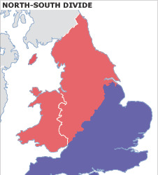
… Which isn’t a north-south divide. It’s a northwest-southeast divide, going up at more than 45 degrees – it’s more an east-west divide than it is a north-south. It also includes Wales in “the North” but we’ll get to that.
But it was a north-south divide he set out to find, so a north-south divide he sort of drew, excluding exclaves and enclaves where the metrics he was looking at would make that not a north-south divide.
Notably, several would seem to put the west country peninsula in “the North”… So what’s up with that?
(Dorling's full paper is here, and I recommend looking through the whole thing to see how he arrived at the divide he eventually concluded: https://www.dannydorling.org/wp-content/files/dannydorling_publication_id2938.pdf)
Anyway. This is what’s up with that:
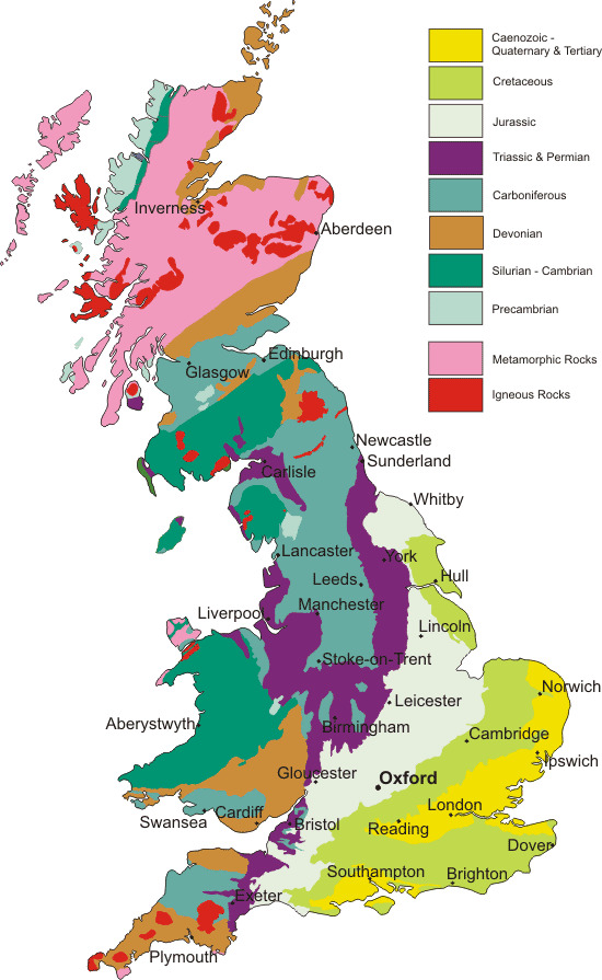
This is a geological map of Great Britain (and the Isle of Man, which isn’t actually part of the UK or any of its constituent countries but I guess it’s here anyway.)
Here again, in the boundary between Jurassic and Triassic geology, is that diagonal line from the Humber to the Severn, but continuing past both. For convenience, here are those two lines superimposed on one another.
With Danny Dorling’s line (frequently following county boundaries or other administrative boundaries) in blue, and the geological divide in red.
One line was drawn in 2008, the other has existed over 200 million years.
This isn’t a coincidence – it’s the reason for the divide.
What made “the North” is the industrial revolution. And one thing that drove the industrial revolution was the mines: coal, iron, silver, tin, the rocks beneath our feet and the people who dreamed they were worth more than the people they sent into the dark to bring it into the light.
Towns grew around mines, from Walker to South Crofty, and more than just the mines defining them, it was the mines closing that would cement the divide.
“Byker Hill and Walker Shore, collier lads forever more”
“Cornish lads are fishermen and Cornish lads are miners too”
- Two folk songs about regional identity’s roots in its industry, from opposite ends of this dividing line
In the West Midlands, the Black Country didn’t earn that name with caviar; it, like Manchester and Leeds, reinvented itself when the industry collapsed: cities built in the brick ruins of the temples built to the exploitation of the workers, blackened by the smokes of the cremation of its labour industry. When the light catches the steel and glass just right, you can still see the ghosts.
Even the country life outside the cities is shaped by this geology: the terrain north-west of this line doesn’t lend itself to large, flat expanses of land for arable farming, and the divide is visible again when looking at agriculture:
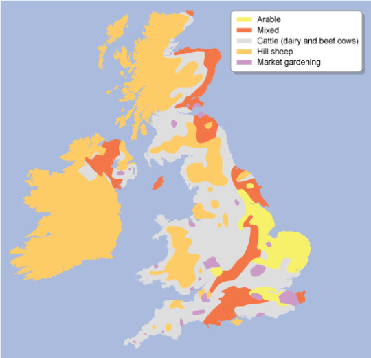
With the majority of land south of the Jurassic-Triassic line being arable, mixed and market gardening, with a fair amount of cattle in the Cotswolds and Chilterns and along the north side of the Thames, and the majority north-west of it being cattle and sheep – which are almost absent from the south side of the divide with the exception of the Isle of Wight and therefore, ironically, Cowes.
Not all farming is the same, the yearly flow of labour and of marketable goods between livestock and arable having little in common beyond being intensive work out-of-doors and taking huge amounts of land to accomplish.
But one thing that also goes hand in hand with this is that sheep aren’t mostly farmed for their meat but for their wool, and what drove industrialisation in the Pennines was the steam-loom: the mechanisation and mass-production of wool.
(Incidentally, on this map arable farming and market gardening also correlate with several types of English traditional dance: Molly, Border an East Midlands and East Riding plough dances, which began as a way for seasonal farmhands to make ends meet by busking with menaces in the winter off-season, but that’s for a later Morris ramble).
But hang on, that puts Hull on the same side of the divide as Kent, not, for example, Liverpool. So what gives there?
The East Riding isn’t built on mining - a kid with a bucket and spade could find the water table in most of the county.
Hull, and other ports of Yorkshire with it, was built on whaling – and not many industries have collapsed harder than whaling. For once, the geography of the land has little impact on this, but the geography of the sea does:
Between England and the European continent is a shallower stretch of sea called Dogger Bank – named for the Dutch cod-fishing boats known as Doggers which fished on it. But shallow water isn’t great for whales. So where is there water good for whales?
Well, whalers from Great Britain would venture as far as the Antarctic ocean in search of whales, and often hunted off Greenland – but there was water closer to home where whales did and still do frequent:
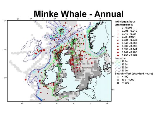
(There is still whaling in the North Sea. Around 500 minke whales are killed by Norwegian whalers each year “in objection to” the global ban on commercial whaling.)
Outside of this, there’s also a divide between port cities dealing primarily in cargo or primarily in passengers, something which is somewhat evening out by one means or another, but here’s a current map of UK passenger ports and their passenger numbers:
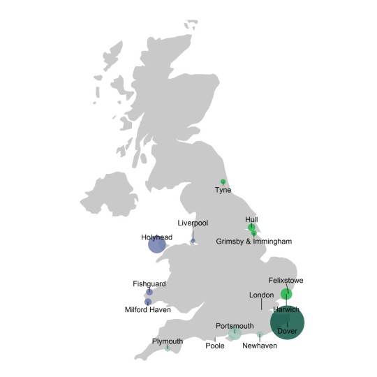
Or at least circles sized to correspond to their passenger numbers - source with stats: https://www.gov.uk/government/statistics/sea-passenger-statistics-all-routes-2021/sea-passenger-statistics-all-routes-2021
Compare this with a map of cargo ports by load:
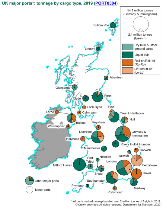
Source with numbers: https://safety4sea.com/uk-ports-record-steady-performance-during-2018/
Generally showing passenger numbers getting lower the further you get from Dover, but not the same correlation with cargo (Plymouth and Holyhead both bucking this trend at a glance).
So, if not “The North” and “The South”, what name does make sense for this divide?
I propose “the South” be known as Lloegyr.
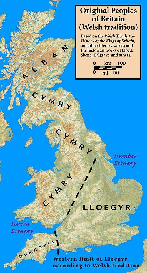
These names still exist: Domnonea still exists in Brittany both as a name for that same region from which Brittonic settlers came to Brittany and an area of Brittany named for them, and in Welsh, yr Alban is Scotland, Cymru is Wales and Lloegr is England.
Wales isn’t part of “the North”. “The North” is part of Wales.
271 notes
·
View notes
Text
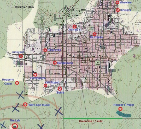
Posting here for writing purposes. Have no idea where this is from sawry
#mike and lucas cycling alllll the way across town to apologise is actually a little nuts#will byers u are so loved and cherished…#also interesting how there isn’t really any solid divide in wealth in areas#like I would’ve thought north rich south poorer#but the harringtons being close to the byers wouldn’t rlly make sense in that case#also inch resting how seperate the byers house is from everything else#like they’re so alienated#Ok anyway I need to stfu#stranger things#will byers#byler
21 notes
·
View notes
Text
Our top issues for the General Election no. 2:
Reverse the £3.6 billion cuts made to public spending in the North during austerity.
Want to keep the pressure on Westminster politicians?
Ask your candidates: "How will you address long-term inequality in public funding between the North and the South?"
21 notes
·
View notes
Text
Giorgia Meloni accused of splitting Italy over law to let richer regions keep taxes
Critics say differentiated autonomy bill, which sparked brawl in parliament, will increase poverty in south
Angela Giuffrida in Rome

Italy’s far-right prime minister, Giorgia Meloni, has been accused of “splitting the country” after parliament approved a controversial bill granting regions more power, which critics say will increase poverty in the south.
The change, approved by the lower house early on Wednesday after a fiery debate that lasted all night, is part of the government’s overhaul of the Italian state, including a bill approved by the upper house on Tuesday that would allow for the direct election of a prime minister.
The “differentiated autonomy” bill, sought by the wealthy rightwing-led Lombardy and Veneto as well as the leftwing Emilia-Romagna, gives regions more power over how their tax revenues are collected and spent, and over public services such as health and education.
The approval of the bill, which passed with 172 votes in favour and 99 against, was hailed by Matteo Salvini, the leader of Lega, the ruling coalition member which for years has championed the move, as “a victory for all Italians”.
Meloni said it was “a step forward towards building a stronger and fairer Italy”, and argued it would “overcome the differences there are today between various parts of the country”.
Critics say that if the wealthier regions are able to keep more of their tax earnings it will mean fewer financial resources for poorer regions, which are predominantly in the south.
The measure was so bitterly contested it led to a brawl in parliament last week, with a politician from the opposition Five Star Movement needing medical assistance. The fight triggered a demonstration by opposition parties in Rome on Tuesday night, who said they were rallying “to defend national unity” in the face of the two bills and to protest against alleged “violence and intimidation” by the ruling coalition.
Elly Schlein, the leader of the centre-left Democratic party (PD), said the measure was divisive and would increase inequality. “Meloni, the patriot who splits the country,” she said. “Brothers of Italy has bowed to Lega’s secessionist dreams.”
The bill allowing the direct election of a prime minister is a significant constitutional overhaul which Meloni has vigorously promoted, describing it as “the mother of all reforms”.
Under the proposal, the prime minister would be elected for five years and the coalition supporting the winning candidate would be given at least 55% of seats, a law Meloni argues would help end Italy’s revolving-door governments. Critics fear the bill, reminiscent of a constitutional change made by the fascist dictator Benito Mussolini about a century ago, could lead Italy towards authoritarianism.
Any change to the constitution must be approved by both houses of parliament with a two-thirds majority. The upper house vote fell short, a result expected to be repeated in the lower house, meaning the bill will almost certainly be put to a referendum, which could be held in 2025.
Source: The Guardian
#italy#italia#giorgia meloni#politics#italian politics#automomia differenziata#lega#lega nord#matteo salvini#elly schlein#southern italy#south italy#north south divide#poverty#benito mussolini#governo meloni#north italy#northern italy#lombardy
18 notes
·
View notes
Text
U know Jack has assimilated by the way he says south wales specifically at the end of season three. North wales is a different place. We don’t know anything about that
#the Welsh north/south divide is rlly funny bc we don’t hate each other we just may as well not exist to the other half#someone from north wales starts listing where their ppl are from and I’m like ???? sorry no#different culture#misc#torchwood
13 notes
·
View notes
Text
"It's pronounced caaarster sugar" - Dan pronouncing caster sugar wrong
22 notes
·
View notes
Video

flickr
Looking to Mount Patterson and Mountains of the Continental Divide (Icefields Parkway) by Mark Stevens
Via Flickr:
A roadside stop between Petyo Lake and Waterfowl Lakes. Here I turned to look to the south and caught a view of Mount Patterson just above the nearby evergreen trees. What I loved about this view was how the greens were such a contrast to the blue skies and clouds above.
#Banff National Park#Blue Skies with Clouds#Canadian Rockies#Central Main Ranges#Day 4#Evergreen#Evergreen Trees#Highway 93#Hillside of Trees#Icefields Parkway#Looking South#Looking to Continental Divide#Looking to Mountains of the Continental Divide#Mount Patterson#Mountains#Mountains in Distance#Mountains off in Distance#Nature#Nikon D800E#North Waputik Mountains#Project365#Snowcapped#Trees#Waputik Mountains#Alberta#Canada#flickr
6 notes
·
View notes
Text
Absolutely fascinated to know where all this amazing public transport is in the south west that northerners keep insisting exists down here. I'm from the biggest city in the south west and when I went off to uni in the Midlands all I could talk about was how much better the public transport was. If you mean London/the south east for the love of god say that.
#the north south divide does exist but people exaggerate it to the point where it genuinely counteracts class solidarity#also most of the time the south west is not included in the conversation#poor people exist in the south you are not inherently working class because you are northern Jesus Christ
5 notes
·
View notes
Text

yanks are mad under that carpincho post
#fugo.txt#also have none of you heard of a rhetorical question. no one wants you to tell us where theyre from#wow u know carpinchos are from south America!!! youre so cool 🥰#pet peeve but calling urself plain ''southener'' or ''northern'' doesn't clue anyone in to where ur from#the world is commonly n famously divided into south and north by the ecuator line 👍#the usa isn't tge only country in fact i wish it wanst a country at all#should i make a tag for me complaining. i feel like i complain too much#i think u guys should b able 2 filter it
4 notes
·
View notes
Text
the fact that oliver would be considered upper-middle class in the north (purely bc of the yearly holidays) but can't even make a dent into the upper classes in the south is...
#saltburn#do people understand the general gist of the north/south divide in england#freddos orginals#oliver quick
10 notes
·
View notes
Note
hi! so im super curious about this post and what you mean by blood curse? could you talk more about it? it’s a very interesting take and I want to hear more of what you think
hmm yeah! it's kind of more of a figure of speech than anything lol— i don't think there's like, a literal magical Blood Curse physically destroying anything— but it's more of a thematic curse. there's something to be said about how the red wedding is kind of the Definitional Asoiaf Moment right. asos is a book very much concerned with breaking taboos and natural laws-- breaking of guest right at the red wedding and at craster's, the kingslaying of robb and joffrey, tyrion's kinslaying of his father, bran's possession of hodor (maybe more that i'm forgetting). but the red wedding is like. The moment. it's such a moment, in fact, that it ripples backwards in time through asoiaf's prismatic dreamscape. theon sees the red wedding months before it happens in his dreams, dany sees it at the house of the undying, jon and bran (iirc?) both see it in their dreams as/after it happens. it's such a genuinely heinous act against nature it bleeds through time. bleeds through the book itself!
tywin orchestrates it to win the war "cheaply" but the rent comes due in affc, a book about examining the consequences of a world whose enforced codes and ideals (the chivalric paradigm itself!) are so deeply unnatural, so contradictory and dissonant that they are destined for collapse. where asos is about the breaching of natural law, affc is about unnatural law being laid bare as a result (why affc feels more thematically concerned with gender, for example). tywin is not a figure of perfection but just a rotting body. more rotten than usual. they keep telling me that house lannister won this war! all those honour codes and norms and stories are only hiding deeply entrenched violences (eg. if gender norms are so natural why must they be enforced through violence?). beneath the golden sheen of chivalry is just a nightmare of blood. the red wedding is so foul an act that it can't be covered up in shrouds like rhaegar's children were. the emperor has no clothes now! you cannot look away from it, look without seeing, or go away inside forever. the curse is blood begetting blood, like lady stoneheart's wraith, who can think of nothing but feeding on death. it's something that begs to be witnessed so powerfully that it rips through the psychic realm. yeah alright i read this over and it makes no sense and im talking about like four completely different things ah well Siri send post
#i think there's a lot of talk about how bc of the red wedding the lannisters actually 'lost' and the starks actually 'won'#because no one will fight for tywin's memory but the northmen will fight for ned's. bathing in bolton blood etc#and like Yeah but i also think it's bigger than that#asoiaf#cause like i dont think it's necessarily a north v south divide. The North Remembers is a war cry#it's not like.. aspirational. northern paradigm is just as built on blood (and barrows!)#it's not like the north doesnt Also have gender roles ukno. it's not black and white it's more complex than i can get at#ned's still indoctrinating his sons into ritualistic violences etc etc#i'd be interested in diving in a bit more into the difference between 'sacred' 'natural' laws like guest right and kinslaying#and like. 'unnatural' 'chivalric' laws#Anyway wow this is just like the nibelungenlied.
99 notes
·
View notes
Text
Ah, Network North apparently means North London. Quelle surprise, the North is last in the queue even for its own funding.
11 notes
·
View notes
Note
assumption based on your blog: you live in North America
Also correct!
Although continents are fake much the same way that gender is fake -- I've used the analogy "Yeah, I say I'm a cisgender woman in the same way I say I live in North America -- it's an easy shorthand and everyone knows what it means, but the category kind of falls apart on any real examination."
Sorry, "Continents are fake" was one of the most mind-blowing personal revelations of my adult life. But yes! You are correct!
#asks#send asks#all natural categories are socially mediated#even landmasses#because what is a “land” “mass”?#how can the dividing line between North America and South America be the Panama canal when a canal is manmade?#how can the dividing line between Asia and Africa be the Suez canal when a canal is manmade?#how can the dividing line between Europe and Asia be a MOUNTAIN RANGE that is not EVEN playing by the already-fake rules of continents?#everything we were taught about natural categories of the natural world is just somebody drawing lines!#my first “reference question” as a library worker was “how many continents are there?” and OH BOY did I make that poor sap regret asking!#“wait! come back! we have to talk about the social construction of geography!”
4 notes
·
View notes
Text
Michael Gove's cathedral:

22 notes
·
View notes
Last Seen Blogs

isaiahsl
As Luck Would Have It

peace-blooms
in it to Wrynn it

isamin1031-blog
新選組 tumblr 屯所

ironmaidenmerch
Iron Maiden Merch

lexthechef78
Untitled