#route maps
Explore tagged Tumblr posts
Text
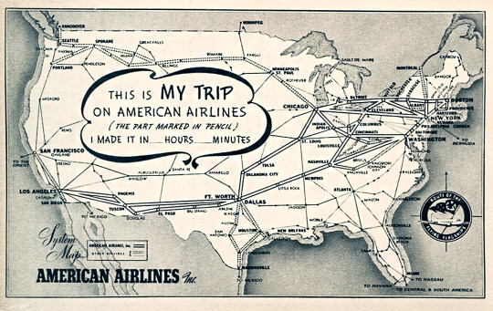
American Airlines system map - 1939.
#airports#vintage illustration#vintage aircraft#aircraft#commercial aircraft#civilian aircraft#airplanes#vintage airplanes#passenger planes#airlines#airliners#american airlines#airline route maps#vintage maps#route maps#system map
5 notes
·
View notes
Text
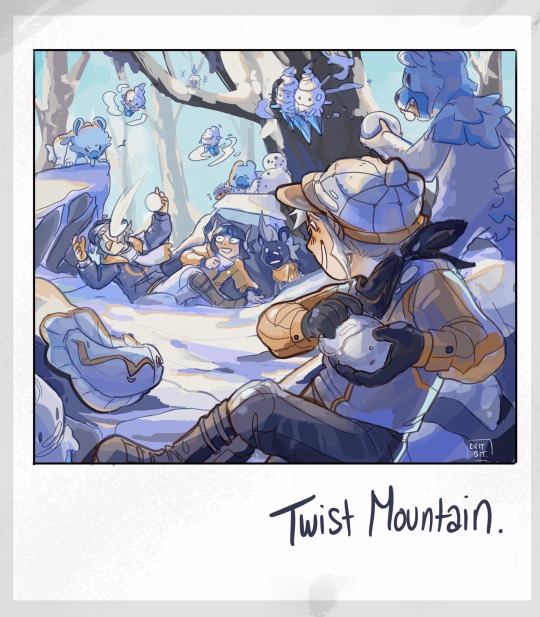

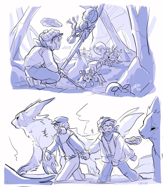
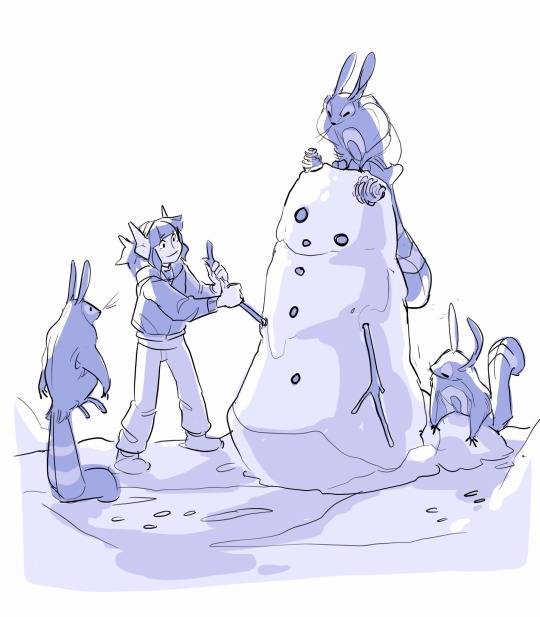
Tis the season on Twist Mountain! Elesa, from Sinnoh, happily tromps around in the cold. Emmet remains undefeated champion of snowball fights. Ingo shivers his way across the clearing.
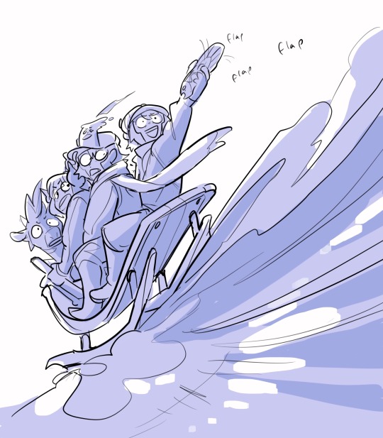
Look at em go!
Masterpost for more pokemon!
#unova has a rotating weather system and i love it#when its winter snow blankets certain routes. freezes puddles and changes the map.#and sinnoh’s snowy year round#idk i think elesa would like the snow#emmet thrives year round he’s a hardy lil fellow#ingo does best during summer like some sort of helioptile soaking up the suns eays#pokemon#sketchbook#art#submas#nimbasa trio#myart#fanart#pokemon ingo#submas comic#pokemon emmet#pokemon elesa#twist mountain#litwick#dwebble#tynamo#blitzle#vanillite#vanilluxe#cubchoo#cryogonal#durant#zangoose#sentret
4K notes
·
View notes
Photo
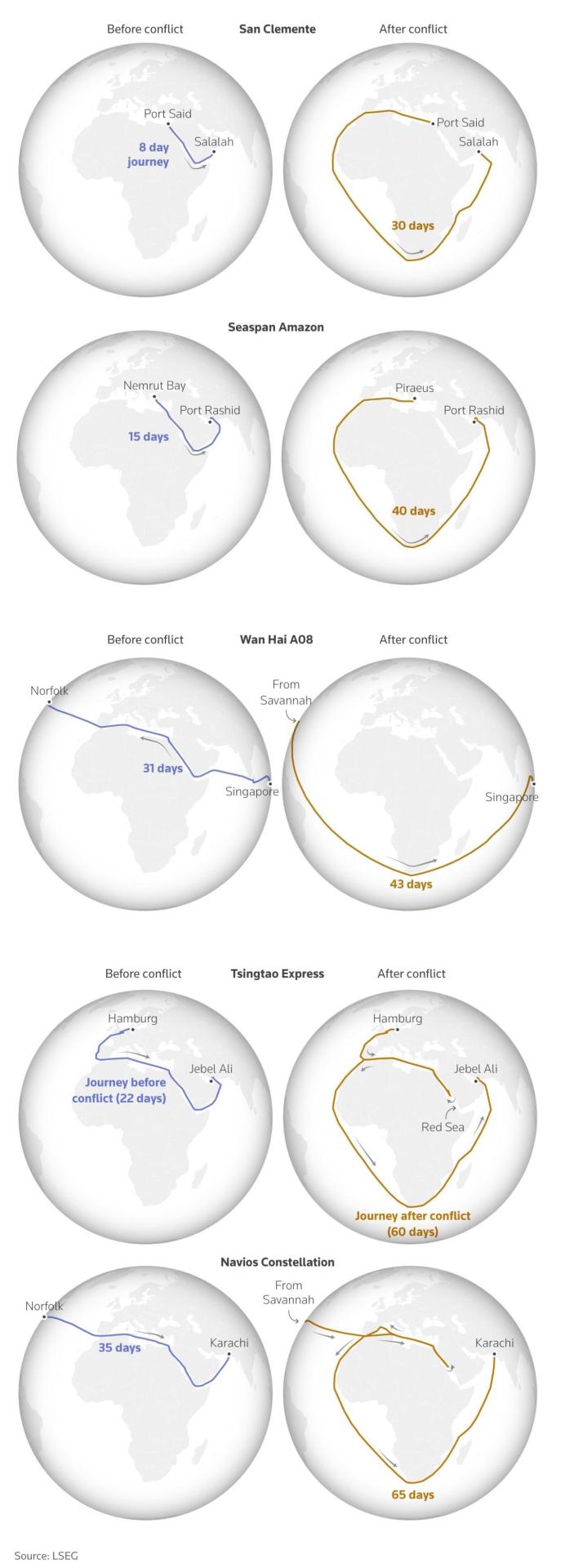
International shipping routes before and after the Houthi attacks in the Red Sea
1K notes
·
View notes
Text
Gil-galad: can i not have one normal day? One.
Elrond: *starts inching toward the door*
Gil-galad: I'm going to teach you how to do my job so I can offload - I dunno - the burden of leadership. Why are you walking away. Elrond, stop using that excuse, you ARE somehow related to all of us and you absolutely CAN be High King of the Noldor get your half elven ass BACK here

Inspired by this hilarious Gil-ga-accurate text post from @greenleaf4stuff! Check it out! - I laugh every time!!
#they have this conversation weekly.#Elrond mapped out escape routes.#Gil-galad’s robes make him trip and he’s not fast enough#Elrond has taken that strategic weakness into account. of course.#well it make ME laugh ok#incorrect quotes#the rings of power#rings of power#elrond#Elrond peredhel#Gil galad#high king gil galad#ereinion gil galad#trop crack#oh and by my two faiths and troths my lords *i* have spoken *mine*
184 notes
·
View notes
Text
Had a dream that the Bachelor route of pathologic 2 came out and Daniil was SO small and SO angry that it was a gameplay feature… like his walking speed was abysmal but he’d walk faster if he got angry so ppl were finding ways to piss off npcs in conversation and timing it so that they’d just stop every now and then on their trek across town to argue with a drunkard and keep powerwalking
#there were maps on the subreddit of who had conversations available at different times in different places#and people were planning routes based off of this to maximize speed#insane#pathologic#bird sings
903 notes
·
View notes
Text
For merthur fic writing reasons I must know: has anyone ever attempted to map the interior of Camelot in a way that makes any sense at all???
#yes I know I could just make shit up but first I must try the superfluous attention to detail route#so grateful for the writer who already tried to make a working map of the five kingdoms and note traveling distances and political info#bbc merlin#merlin#caitie speaks
70 notes
·
View notes
Text

You know you’re in for a good doomed polar voyage when it opens with a map that looks like a fucking etch a sketch
#books#maps#polar exploration#cannot stop laughing at this route#maritime history#madhouse at the end of the earth
197 notes
·
View notes
Text


Road trip 🚗✌️🏽
One day I would like to experience one but only in an RV
#black girl aesthetic#black girl blogger#black girls of tumblr#pinterest#black girl joy#black girl magic#soft life#black girl beauty#luxury#soft girl era#living life#solo living#finding solace#balance#road trip#route 66#motel 6#next stop#rest stop#driving#maps#vegas#nebraska#california#good vibes#positive vibes#melanin#happiness#fun vibes#chill vibes
109 notes
·
View notes
Text
So, sometimes while playing botw/totk, I like to take out my horses and do long journeys across Hyrule, to take a break from fast travelling and completing quests.
Since I just got a new horse way down south (her name's Urania!), it seemed like the perfect excuse to take the long way to Link's house. Usually I map out the way before hand, so I know which route to take, and what stables/towns we are stopping at. Because I wanna feel like Aragorn I suppose.
This was the completed route, starting in Highland Stable, Faron, towards Link's House in Akkala:
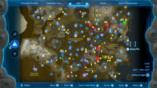
It took us about 2.5 days to make the journey, with 3 stable stops in Dueling Peaks, Woodlands, and finally Foothill, with a short stop in Kakariko Village to get some supplies and food.
I realise now I could've continued north towards Riverside Stable, instead of east Dueling Peaks but. Oh well. It was a very pleasant trip either way!
(pics and deets below):

So, we took off from Highland Stable and headed east, around Lake Hylia. Crossing the Hylia bridge would be easier, but there's a fire gleeok there and I'm very scared 😌💙
It wasn't easy to cross Farosh hills on horse, but we made it! Took us a day's worth.
(I forgot the Big Twin bridge wasn't in use, so I did try my best to find a different way for Urania to cross, but no deal. I had to cheat a little and use the stable boarding function 🥺)

Then next day we took off early and stopped by Kakariko to buy some more arrows for me and carrots for the horsie 🥹🥕

Left the village by 9:30, passed by Wetland stable, and continued north to Woodland stable.

We spent the night, and I left Urania there while I took care of some nearby affairs (aka a shrine and a couple other things). She behaved super well so I mafe sure to give her some extra apples before we took off again 🥹
We only had a few hours of daylight left, so we only went around Trilby Valley, and stopped at Foothill for the night (horse girlie needs to rest and also I didn't wanna be arsed with all the stalkoblins and such 🙃).
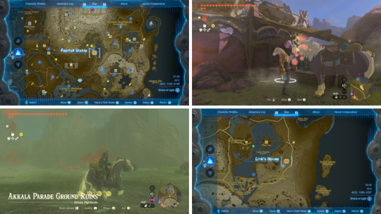
Next morning we left early once again, and after some very annoying storms and rain, we at last reached home 🥹💙
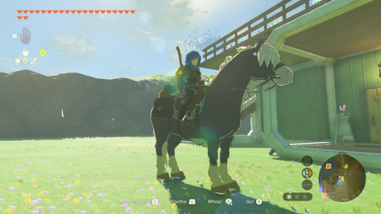
It was Urania's first journey EVER, and she did wonderfully 🥹💙🐎
#this post will interest no one one but me but it's here anyways. because i LOVE doing these long journeys and documenting them!#me checking the map before and decided which routes to take and where should i detour: wow just like Mr Strider in LOTR#do i *need* to rest and buy food? not really. do i like to do it anyways? YEAH#i use fast travel (shrines) a lot so it's nice to take the long way sometimes#whenever i'm out and about exploring is always through the mountains and forests etc at random#so i don't always have the “on the road” experience. it's cool!!#especially if you've been grinding a bit for shrines and quests and stuff#i wish it were a bit easier to travel by horse tho. there's so many areas that it's impossible to cross#it would've been cool to have an alternative path that didn't consist of going around half the map#but i guess that's part of the fun right? yeah#anyways. this is a scheduled post!! i'm writing this quite late what else is new) so you're getting this at more appropriate hours#the legend of zelda#tears of the kingdom#loz#totk#loz totk
23 notes
·
View notes
Text

coruscant map, star wars galactic maps: an illustrated atlas
tumblr: wtf is wrong with you trying to upload a 80.4mb png???? FINE. you can have the halfsize in a jpg then.
#keeping up with the skywalkers#this map completely ignoring the route obi-wan & anakin chased zam wessel on in aotc#it doesn't work!#if it was a mirror of itself it might
40 notes
·
View notes
Text
map with a possible route and shots from the show for anyone else who has been Wondering
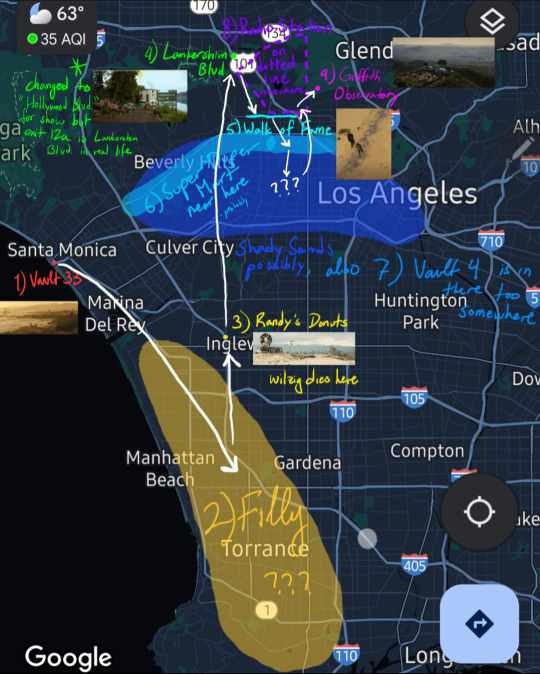
vault 33 → Filly: 4-8 hrs, 10-21 mi
Filly → place where Lucy cuts Wilzig's head off: 2-5 hrs, 5-14 mi. it rly depends on where the hell Filly is (I've mistakenly highlighted LAX but it's further south than that just pretend for me I can't fix it now jfncnfkf)
Wilzig's body → lake with Gulper in it: 7 hrs, 17 mi. right by Universal Studios, btw
the ghoul drags her off course here
Gulper → Hollywood walk of fame: 3 hrs, 6 mi
walk of fame → super duper mart: according to the wiki super duper mart is near santa monica boulevard so i highlighted the whole thing, but it only makes sense for them to go through the walk of fame if it's the east side of the blvd,, 😥 anyways, it's a short walk, like 30 min and 1.5 mi tops
super duper mart → Max/Shady Sands → vault 4: Lucy links up w Maximus somewhere close, and they visit Shady Sands before wandering into Hawthorne medical labs/vault 4. I dunno how to estimate this part of the journey, they could've gone anywhere in that blue area
they spend more than one day at vault 4, I think. Lucy also mentions being on the surface for about two weeks when they leave
vault 4 → radio station with fiddle guy: 4-6 hrs, 10-15 mi
radio station → Griffith Observatory: 2-3 hrs, 4-7 mi
travel time: ~25-40 hrs
total distance: 60-100 miles
added some stuff, but the photos and locations are based mainly off this reddit post
#fallout tv series#fallout prime#fallout show#lucy maclean#the ghoul#maximus#map#route#text#location#please let me know if there are discrepancies or details i missed i wanna know
46 notes
·
View notes
Text
just finishing my asos reread and suddenly I’m like hang on lol was Varys egging Tyrion on here


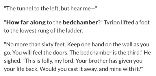

#I guess having Tywin out of the picture actually serves Varys very well so maybe he planned this route#I did assume before that Tyrion’s detour was an inconvenience but Varys is practically handing him a map#asoiaf
469 notes
·
View notes
Photo
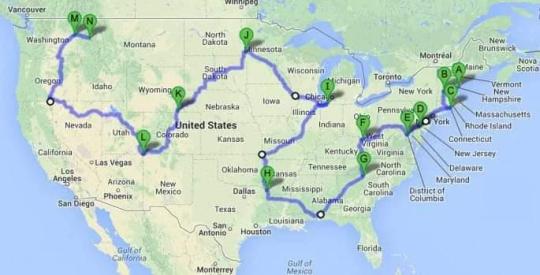
The shortest driving route through all 48 contiguous US states. Takes 113 hours.
2K notes
·
View notes
Photo


Old Highway Route 108
#Con stop yapping#Squid 2 the evolution of the squid#I saw an attempt to figure out Lemuria hub’s rail map that assumes Route 108 was the orange rail line and#well I mean there COULD be a rail line there too I guess. but I severely doubt it and it’s a Highway. it’s road
48 notes
·
View notes
Text
just experienced a truly cinematic moment in tld. it’s -30 out, my warming buff wore out thirty minutes ago, my temperature bar is in the red, and I’m actively developing hypothermia. I was trying to make my way to the camp cabin on the edge of mystery lake, but I got completely turned around. I can hear the howling of wolves in the distance, I’ve already had to chase a few off with my flare, and said flare has just burnt out. I know vaguely that I’m near the edge of the map, but it’s cloudy, and I can’t tell what direction I’m going. I know for sure that bears can spawn near the map border. I’m genuinely terrified.
I push my way over a snowdrift and find myself in a clearing. It’s all white and grey and black, I can’t make out anything distinct. Until…
There, set against a boulder, the same gray as the other boulders, is a cross. And another one. Slowly my vision carves away at the grey mass before me, and I see, for the first time, the face of my savior: Trapper’s Homestead.
My heart leaps into my throat. I run, as fast as I can, hoping against hope that no wolves leap after me, that no bear comes lumbering round the corner. I scramble up the footpath, not even bothering to check for edible plants or dropped tools, and throw open the door to my salvation.
…
I’m going to bed, man, that was a crazy adrenaline rush. I’m gonna strip the cabin of its treasures tomorrow, I’ve already found a military coat and a revolver, which is sick asf, plus I poached a rabbit off of a wolf.
#the long dark#mystery lake will be the death of me both in game and out of game#this is the EASIEST map ?? IM FIGHTING FOR MY LIFE#also gotta find an efficient route back to the firewatch tower bc I left a toooon of shit there including maybe a snare? which isn’t ideal#hopefully the rabbit guts will be enough to craft a new one
15 notes
·
View notes
Note
Not sure if there's anything official- based only on a vaguely similar shape and location and seemingly supported by the map pictures released by Dreamworks TV recently, would Yaz's island be Frank Island in Yellowstone National Park? Only for JWE2 building reference purposes 😁
It's possible it was used for some visual inspiration, but I think the EXACT location in Wyoming was probably meant to be a little vague, as a fictional location.
#jurassic world chaos theory#I didn't even know what part of Wyoming it was supposed to be exactly until DW released those maps#the only locations I knew for sure were Darius's cabin in the Lake Tahoe area#Sammy's ranch in the Texas hill country area#Brooklynn's apartment was originally supposed to be near Denver I think or at least at one point I was told Denver#because I actually picked the location of the drop off point in Oklahoma on the map and I tried to calculate a spot they could reach in tim#and then the last location I knew vaguely was the port somewhere off the coast of Louisiana haha#jurassic world#chaos theory#jwct#ask#it's usually better not to get too specific with fictional locations unless they're like... landmarks that everyone knows#also as a Texan I can't believe Sammy allowed Ben to take the I 10 all the way down the wrong way to San Antonio#And THEN the I-35 through Dallas and Norman on the way to Colorado#not only is that the long way#but it's also a truly AWFUL drive during rush traffic LOL#the correct route would have been to take highway 83 out of Junction and then make your way up to Amarillo and onward#Anyway this is just to say whoever put together the DW maps probably just used major interstates to loosely locate things#i'm not convinced they're 100% accurate
29 notes
·
View notes