#jeremy harbeck
Explore tagged Tumblr posts
Text
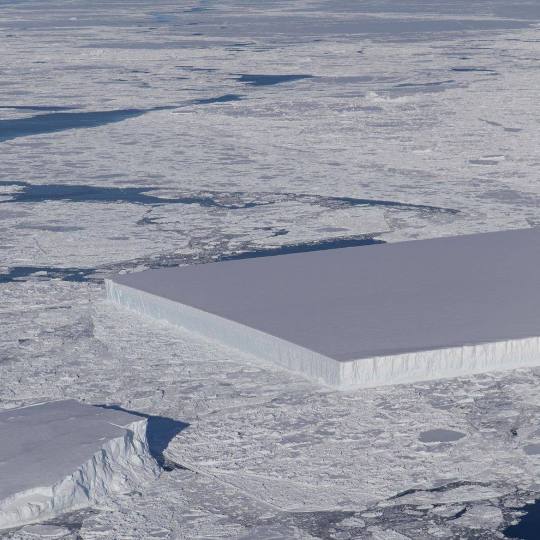
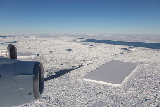
جبل جليدي على شكل مستطيل – 📍القارة القطبية الجنوبية
اكتشف باحثو وكالة ناسا NASA "جبلًا جليديًا مستطيلًا" انفصل عن نهر جليدي كبير في عام 2018 وذلك ضمن عملية IceBridge العلمية.
📸 تصوير: ناسا NASA // بواسطة جيريمي هاربيك Jeremy Harbeck
13 notes
·
View notes
Photo
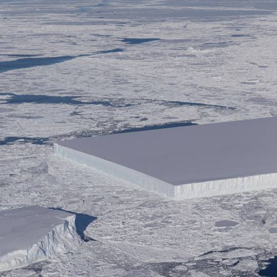
NASA : Not your typical ice cube. 🧊 // Credit: NASA/Jeremy Harbeck
Although it is not uncommon to see icebergs with relatively straight edges, icebergs with two straight edges that converge into a right angle are less common. This rectangular iceberg was pictured in 2018 as part of Operation IceBridge, our longest-running aerial survey of polar ice. From 2009 to 2019, IceBridge flew planes loaded with special equipment over Earth’s polar regions to study sea ice, ice sheets, and glaciers to understand how Earth’s ice is changing. The rectangular iceberg appeared to be freshly calved from Larsen C, a large ice shelf extending from the Antarctic Peninsula. In July 2017, Larsen C also released the massive A68 iceberg, a chunk of ice about the size of the state of Delaware. IceBridge data like this help @NASAEarth scientists better understand the effects of climate change on Earth’s polar regions. Image description: A picture of sea ice extending to the horizon, taken from a low-flying aircraft. Where the ocean peeks through the ice is dark blue. Most of the ocean surface is covered in rough-looking white ice, thinner and thicker in some places, interspersed with sea ice icebergs. The icebergs have flat tops and sheer edges that rise above the sea ice. At this scope, perspective is hard to tell, but the icebergs rise far out of the water. In the center of the frame, an iceberg dominates. It is cut off to the left of the image, but the visible half looks almost perfectly rectangular, with smooth, straight edges and two precise right angles for corners.
#NASA #Iceberg #Antarctica #Ice #Ocean #Earth #ClimateChange #SeaIce
#nasa#iceberg#antarctica#ice#ocean#earth#climate change#sea ice#operation icebridge#jeremy harbeck#elements#photography#science#nasaearth#nasa earth
6 notes
·
View notes
Photo
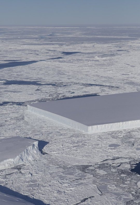
Photo credits: NASA / Jeremy Harbeck
#art#photography#aerial#aerial photography#iceberg#rectangle#nasa#jeremy harbeck#nasa ice#nasaice#nature#earth#larsen C Ice shelf#minimal#white#tabular
31 notes
·
View notes
Photo
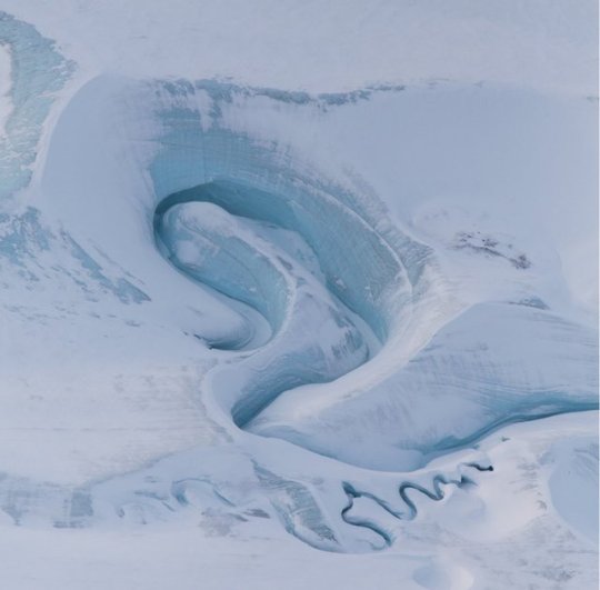
Meltwater channels are carved into DeVries Glacier in the Canadian Arctic. This aerial image was captured on March 29, 2017.
Credit: NASA Goddard/Jeremy Harbeck
12 notes
·
View notes
Photo
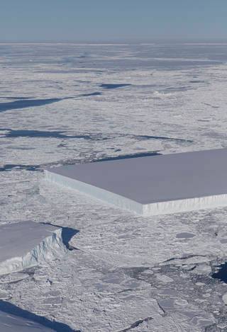
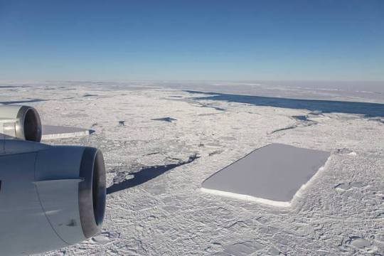
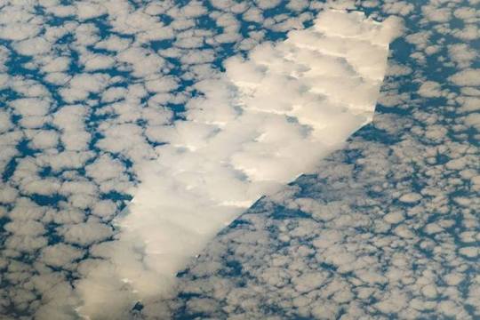
Strange icebergs
NASA’s annual endeavour called Operation Icebridge that keeps tabs on the changing cryosphere in our fast warming world often brings sightings of odd and interesting features in the world’s frozen regions (see https://bit.ly/2qQefLx). The latest crop features a couple of interesting rectangular tablets of ice spotted in mid October in the sea washing the northern Antarctic Peninsula (the bit that juts out towards the tip of South America), just off the Larsen C ice shelf that the flight from Punta Arenas in Chile had set out to monitor (see https://bit.ly/2Q6TNV2). The operation’s deployment for this year ends tomorrow. Another interesting iceberg makes a telling point about the fate of the world’s ice (when there last was this much CO2 in our atmosphere there was no frozen water to be found anywhere on the planet’s surface). Part of the remnants of a huge calving event 18 years ago in the Ross ice shelf (also in Antarctica) it is shaped like a coffin, describing metaphorically the now near inevitable fate of the world’s cryosphere. Having spent years refining its shape as it circled the White Continent in the Circumpolar Current, B-15T as it is known has now shifted north into warmer waters, where it will melt away. The photo with the layer of cloud above it was taken from the International Space Station.
Loz
Image credit: NASA 2: NASA/Jeremy Harbeck
https://bit.ly/2TeqtL2 https://go.nasa.gov/2DjuGrr
#Iceberg#ice#icebridge#larsen c#punta arenas#chile#atmosphere#science#B-15 T#the earth story#ISS#Space station
255 notes
·
View notes
Text
Huge Cavity in Antarctic Glacier Signals Rapid Decay
NASA - Operation IceBridge Mission patch. January 30, 2019 A gigantic cavity - two-thirds the area of Manhattan and almost 1,000 feet (300 meters) tall - growing at the bottom of Thwaites Glacier in West Antarctica is one of several disturbing discoveries reported in a new NASA-led study of the disintegrating glacier. The findings highlight the need for detailed observations of Antarctic glaciers' undersides in calculating how fast global sea levels will rise in response to climate change. Researchers expected to find some gaps between ice and bedrock at Thwaites' bottom where ocean water could flow in and melt the glacier from below. The size and explosive growth rate of the newfound hole, however, surprised them. It's big enough to have contained 14 billion tons of ice, and most of that ice melted over the last three years.
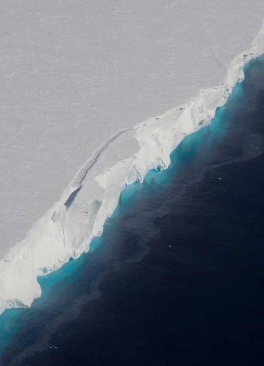
Thwaites Glacier. Image Credit: NASA/OIB/Jeremy Harbeck
"We have suspected for years that Thwaites was not tightly attached to the bedrock beneath it," said Eric Rignot of the University of California, Irvine, and NASA's Jet Propulsion Laboratory in Pasadena, California. Rignot is a co-author of the new study, which was published today in Science Advances. "Thanks to a new generation of satellites, we can finally see the detail," he said. The cavity was revealed by ice-penetrating radar in NASA's Operation IceBridge, an airborne campaign beginning in 2010 that studies connections between the polar regions and the global climate. The researchers also used data from a constellation of Italian and German spaceborne synthetic aperture radars. These very high-resolution data can be processed by a technique called radar interferometry to reveal how the ground surface below has moved between images. "[The size of] a cavity under a glacier plays an important role in melting," said the study's lead author, Pietro Milillo of JPL. "As more heat and water get under the glacier, it melts faster." Numerical models of ice sheets use a fixed shape to represent a cavity under the ice, rather than allowing the cavity to change and grow. The new discovery implies that this limitation most likely causes those models to underestimate how fast Thwaites is losing ice. About the size of Florida, Thwaites Glacier is currently responsible for approximately 4 percent of global sea level rise. It holds enough ice to raise the world ocean a little over 2 feet (65 centimeters) and backstops neighboring glaciers that would raise sea levels an additional 8 feet (2.4 meters) if all the ice were lost.
Animation above: Changes in surface height at Thwaites Glacier's grounding line, 2011 to 2017, with sinking areas in red and rising areas in blue. The growing cavity (red mass, center) caused the greatest sinking. The mottled area (bottom left) is the site of extensive calving. Contours show bedrock topography. Animation Credits: NASA/JPL-Caltech. Thwaites is one of the hardest places to reach on Earth, but it is about to become better known than ever before. The U.S. National Science Foundation and British National Environmental Research Council are mounting a five-year field project to answer the most critical questions about its processes and features. The International Thwaites Glacier Collaboration will begin its field experiments in the Southern Hemisphere summer of 2019-20. How Scientists Measure Ice Loss There's no way to monitor Antarctic glaciers from ground level over the long term. Instead, scientists use satellite or airborne instrument data to observe features that change as a glacier melts, such as its flow speed and surface height. Another changing feature is a glacier's grounding line - the place near the edge of the continent where it lifts off its bed and starts to float on seawater. Many Antarctic glaciers extend for miles beyond their grounding lines, floating out over the open ocean. Just as a grounded boat can float again when the weight of its cargo is removed, a glacier that loses ice weight can float over land where it used to stick. When this happens, the grounding line retreats inland. That exposes more of a glacier's underside to sea water, increasing the likelihood its melt rate will accelerate. An Irregular Retreat For Thwaites, "We are discovering different mechanisms of retreat," Millilo said. Different processes at various parts of the 100-mile-long (160-kilometer-long) front of the glacier are putting the rates of grounding-line retreat and of ice loss out of sync. The huge cavity is under the main trunk of the glacier on its western side - the side farther from the West Antarctic Peninsula. In this region, as the tide rises and falls, the grounding line retreats and advances across a zone of about 2 to 3 miles (3 to 5 kilometers). The glacier has been coming unstuck from a ridge in the bedrock at a steady rate of about 0.4 to 0.5 miles (0.6 to 0.8 kilometers) a year since 1992. Despite this stable rate of grounding-line retreat, the melt rate on this side of the glacier is extremely high. "On the eastern side of the glacier, the grounding-line retreat proceeds through small channels, maybe a kilometer wide, like fingers reaching beneath the glacier to melt it from below," Milillo said. In that region, the rate of grounding-line retreat doubled from about 0.4 miles (0.6 kilometers) a year from 1992 to 2011 to 0.8 miles (1.2 kilometers) a year from 2011 to 2017. Even with this accelerating retreat, however, melt rates on this side of the glacier are lower than on the western side. These results highlight that ice-ocean interactions are more complex than previously understood. Milillo hopes the new results will be useful for the International Thwaites Glacier Collaboration researchers as they prepare for their fieldwork. "Such data is essential for field parties to focus on areas where the action is, because the grounding line is retreating rapidly with complex spatial patterns," he said. "Understanding the details of how the ocean melts away this glacier is essential to project its impact on sea level rise in the coming decades," Rignot said. The paper by Milillo and his co-authors in the journal Science Advances is titled "Heterogeneous retreat and ice melt of Thwaites Glacier, West Antarctica." Co-authors were from the University of California, Irvine; the German Aerospace Center in Munich, Germany; and the University Grenoble Alpes in Grenoble, France. Related links: Operation IceBridge: https://www.nasa.gov/mission_pages/icebridge/index.html International Thwaites Glacier Collaboration: https://thwaitesglacier.org/ Image (mentioned), Animation (mentioned), Text, Credits: NASA/JPL/Esprit Smith/University of California/Brian Bell/NASA's Earth Science News Team, written by Carol Rasmussen. Greetings, Orbiter.ch Full article
50 notes
·
View notes
Photo
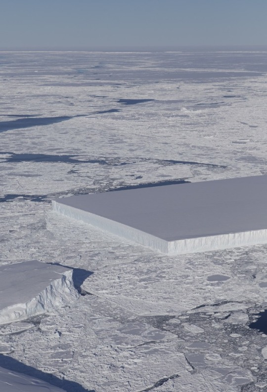
Image taken during an Operation IceBridge flight over the northern Antarctic Peninsula on Oct. 16, 2018. (Photo: NASA/Jeremy Harbeck)
NASA Discovers Incredibly Rectangular Iceberg in Antarctica
https://mymodernmet.com/nasa-rectangular-iceberg-antarctica/?fbclid=IwAR2fdqGx7xXND9AD4guM9Y6EPHPwSDaXvulndR8JaHPnHnVM1obhiRhjX5c
16 notes
·
View notes
Link
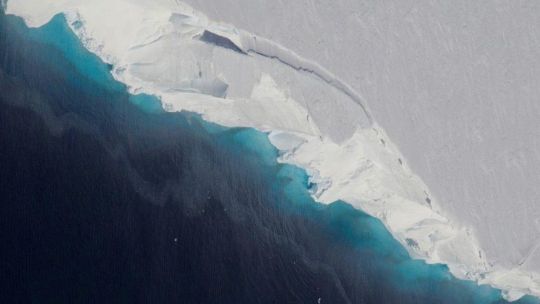
Thwaites Glacier as seen from above. NASA/OIB/JEREMY HARBECK
The story from Forbes:
A new study led by NASA has found a giant cavity in the underside of the huge Thwaites Glacier in West Antarctica. The gigantic void is a thousand feet tall (300 m) and about two-thirds the area of Manhattan Island, according to the space agency.
The researchers estimate that the hole is big enough to have contained 14 billion tons of ice, but most of it was melted over the past three years thanks to ocean water flowing into gaps between the glacial ice and rock below.
"We have suspected for years that Thwaites was not tightly attached to the bedrock beneath it," said Eric Rignot from NASA's Jet Propulsion Laboratory.
Rignot co-authored a new study published in Science Advances that used observations from ice-penetrating radar in NASA's Operation IceBridge and a constellation of newer satellites to take a closer look at what's happening under the giant glacier, which is roughly the size of Florida.
The Thwaites Glacier contains enough ice to raise the global network of oceans by more than two feet (65 cm), but it also acts as a plug of sorts for adjacent glaciers. If all that ice were to also slide into the ocean and melt, it would raise sea levels another 8 feet (2.4 m).
While all that added water probably wouldn't lead to an evenly distributed water level rise across all coastlines, it could be enough to displace over 2 million people from Florida and tens of thousands from other major cities like New York and New Orleans. And that's to say nothing of all those ruined beach homes and fetching coastal retreats.
9 notes
·
View notes
Photo
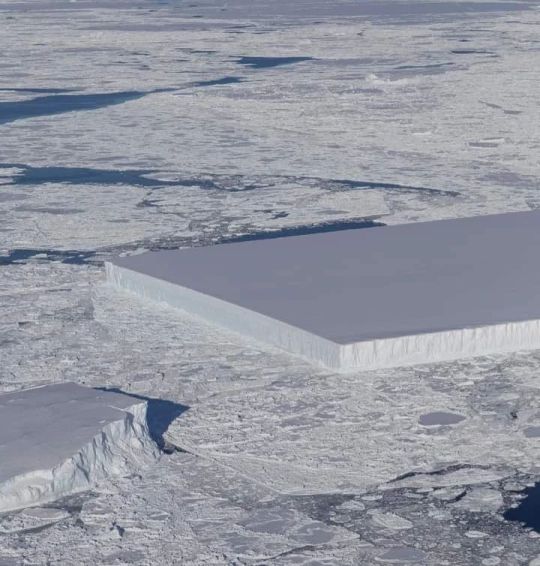
A perfectly rectangular enormous iceberg photographed by NASA near the east coast of the Antarctic peninsula. More images/info: https://t.ly/HcnC 📷 Jeremy Harbeck/NASA (bij Antarctic Peninsula) https://www.instagram.com/p/Cn1XRzaoJPy/?igshid=NGJjMDIxMWI=
0 notes
Text
누누티비 우회접속 안됨 주소 도메인
누누티비 우회접속 알려드릴게요. 접속안됨 일때 해결방법 입니다.
누누티비 최신주소 도메인 <
가장 쉽고 간단한 누누티비 도메인 입니다. 누누tv tv연결 크롬캐스트, 스마트티비 적용 가능합니다. 어플 apk 아이폰도 지원합니다. 빅마우스나 탑건 볼때도 편리하고, 처벌 사례 없으니 안심하고 사용하세요. 끊김이나 버퍼링 해결방법은 다시 껐다가 키면 잘 됩니다.


네이처 지오사이언스(Nature Geoscience) 저널 월요일에 발표된 새로운 연구에 따르면, 해수면을 몇 피트 높일 수 있는 남극의 거대한 빙하가 마지막 예측보다 빠르게 분해되고 있다고 합니다. 스웨이츠 빙하(Thwaites Glacier)는 과학자들이 빙하와 이를 지지하는 빙붕이 없으면 해수면이 3~10피트 이상 상승할 수 있다고 추정하기 때문에 "종말의 빙하"라고 불리는 대륙의 서쪽 부분에 있습니다. 최근에 고해상도로 매핑한 후, 국제 연구원 그룹은 빙하가 6개월 누누티비 우회접속 안됨 주소 도메인 미만의 기간 동안 지난 2세기 동안 언젠가 "급격한 후퇴" 단계를 경험했다는 것을 발견했습니다.
연구에 수반된 보도 자료에 따르면, 연구원들은 빙하가 "해저 능선과의 접촉이 끊어진" 상태로 현재 연간 1.3마일의 속도로 후퇴하고 있다고 결론지었습니다. 이는 2011년에서 2019년 사이에 예측한 것의 두 배입니다. 육지와 연결된 다른 일부 빙하와 달리 Thwaites는 해저에 자리 잡고 있어 인간이 유발한 기후 변화의 결과로 따뜻한 물에 더 취약합니다. Thwaites는 이미 연간 해수면 상승의 약 4%를 차지합니다. 중요한 남극 빙붕이 5년 이내에 붕괴될 수 있다고 과학자들이 말합니다. 연구의 공동 저자이자 사우스 플로리다 대학의 해양 지질학자인 Alastair Graham은 전화 인터뷰에서 "Thwaites를 제거하고 남극 대륙의 나머지 부분을 그대로 둘 수는 없습니다."라고 말했습니다. 그는 Thwaits를 잃는 결과를 "실존적"이라고 설명했습니다. UN에 따르면, 세계 인구의 40% 이상이 해안에서 60마일 이내에 살고 있습니다. 이 지역은 밀물 때 큰 타격을 받을 것입니다. "Thwaites는 오늘날 정말 손톱으로 버티고 있으며, 빙하가 침대의 얕은 능선 너머로 물러나면 미래에 작은 규모로 큰 변화를 볼 수 있을 것으로 예상해야 합니다. 이 연구의 공동 저자인 영국 남극 조사국(British Antarctic Survey)의 로버트 라터(Robert Later).
Thwaites Glacier의 International Thwaites Glacier Collaboration(ITGC) 현장 현장. (Peter Davis/영국 남극 조사) NASA에서 제공한 남극 스웨이츠 빙하의 조감도가 2019년 1월 30일에 관찰되었습니다. (NASA/OIB/Jeremy Harbeck/Handout/EPA-EFE/Shutterstock) 작년 말에 촬영된 위성 이미지에 따르면 Thwaites Glacier의 동쪽 부분을 안정화하는 데 사용된 빙붕이 금이 가는 징후가 나타났습니다. 워싱턴포스트. 그러나 연구원들은 선반의 붕괴가 해수면 상승에 즉시 기여하지는 누누티비 우회접속 안됨 주소 도메인 2022 noonoo tv 않지만 Thwaites Glacier의 침식을 가속화하여 구조에서 바다로 내륙의 얼음을 붕괴시킬 수 있다고 말합니다. Graham은 그의 팀이 빙하 구조가 완전히 용해될지 또는 언제 완전히 용해될지 자신 있게 예측할 수 없지만 향후 75년 동안 지구 온난화 배출량을 줄이는 것이 생존에 결정적일 것이라고 말했습니다. “지금 당장 우리는 그것에 대해 뭔가를 할 수 있습니다. 특히 바다가 온난화되는 것을 막을 수 있다면 말이죠.”라고 그는 말했습니다.
1 note
·
View note
Link
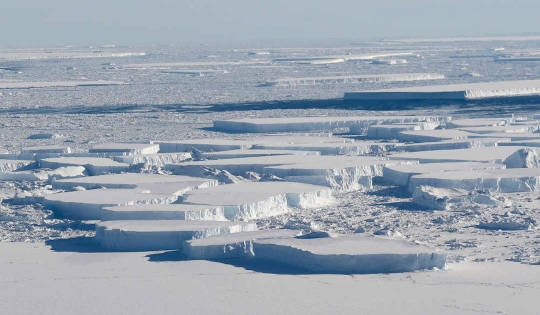
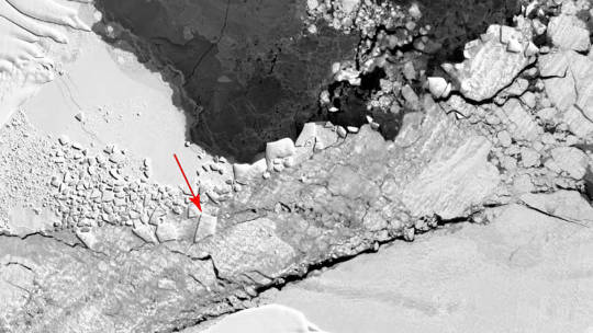
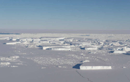
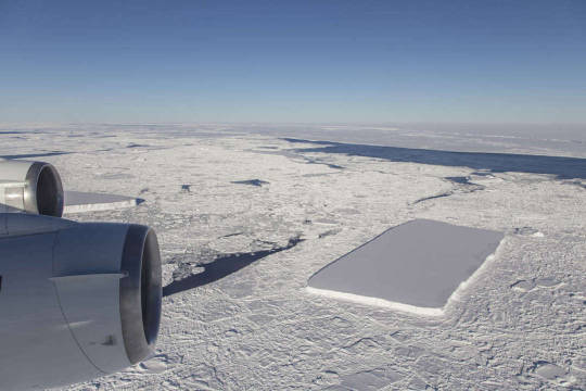
O mundo realmente parou e ficou em choque com as fotos do iceberg tabular, e para satisfazer a vontade do povo, a NASA lançou novas imagens desse e de outros icebergs. Só para deixar claro que isso é a coisa mais normal do mundo, um iceberg de forma tabular. As imagens foram feitas pela missão IceBridge da NASA, essa missão é composta por uma frota de aeronaves, que tem como objetivo estudar o gelo polar da Terra, medindo as mudanças anuais na espessura do gelo no mar, das geleiras e das plataformas de gelo. Esse é o projeto de estudo aéreo mais longo que se tem dedicado para o estudo do gelo na Terra, e o principal objetivo é entender as conexões entre as região polares e o sistema climático global. No dia 16 de Outubro de 2018, um avião decolou para estudar as mudanças na Larsen A, B e C, mas o que chamou a atenção mesmo, foi o iceberg de forma peculiar que assim que teve sua imagem publicada, viralizou nas redes sociais. O iceberg tabular, foi fotografado perto da Larsen C, uma plataforma congelada que tem o tamanho de Delaware, e que ficou famosa por se soltar da Península Antártica em Julho de 2017. “Eu achei isso bem interessante, eu normalmente vejo icebergs com as bordas retas, mas eu nunca tinha visto um assim, com dois cantos com ângulo reto”, disse Jeremy Harbeck, cientista da missão IceBridge. As novas imagens publicadas pela NASA mostram a borda do iceberg viral, outro iceberg um pouco menos quadrado, e o A68, o filho da Larsen C, bem a distância. “Eu na verdade estava mais interessado em capturar o iceberg A68 que iríamos sobrevoar, mas achei o iceberg tabular muito interessante e fotogênico e resolvi fazer algumas fotos”, disse Harbeck. As imagens mostram o iceberg tabular com um diâmetro de aproximadamente 1.6 km com bordas limpas que indicam que ele provavelmente se partiu recentemente. Mas como um iceberg acaba assumindo uma forma uniforme como essa? Icebergs se formam quando o peso de um grande pedaço se solta de uma geleira, de uma plataforma de gelo, ou até mesmo de um iceberg maior. Apesar desse iceberg parecer perfeito demais para ser formado pela natureza, icebergs tabulares são relativamente comuns, como o que acontece na Pobeda Ice Island que forma esse tipo de iceberg periodicamente na costa leste da Antártica. Os icebergs não tabulares são aqueles que a gente tende a pensar que são os mais tradicionais, mas tanto os icebergs tabulares como os não tabulares têm algo em comum, eles provavelmente possuem uma forma mais geométrica abaixo da superfície, e daí, não importa que sejam bonitos, todos eles são um risco para embarcações. Fonte: https://www.iflscience.com/environment/nasa-releases-more-pics-of-that-baffling-rectangular-iceberg-with-a-perfectly-logical-explanation/
1 note
·
View note
Video
NASA Spots Rectangular Icebergs by NASA Goddard Space Flight Center Via Flickr: Operation IceBridge, NASA’s longest-running aerial survey of polar ice, carried a flight over the northern Antarctic Peninsula on Oct. 16, 2018. During the survey, designed to assess changes in the ice height of several glaciers draining into the Larsen A, B and C embayments, IceBridge senior support scientist Jeremy Harbeck spotted a very sharp-angled tabular iceberg floating among sea ice just off of the Larsen C ice shelf. The rectangular iceberg appeared to be freshly calved from Larsen C, which in July 2017 released the massive A68 iceberg, a chunk of ice about the size of the state of Delaware. The flight originated from Punta Arenas, Chile, as part of a five-week-long IceBridge deployment, which began Oct. 10 and is scheduled to conclude Nov. 18. Credit: NASA/Jeremy Harbeck
1 note
·
View note
Photo
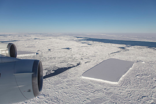
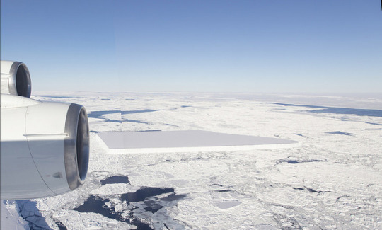
IceBridge senior support scientist Jeremy Harbeck spotted a very sharp-angled, tabular iceberg floating among sea ice just off of the Larsen C ice shelf. “I thought it was pretty interesting; I often see icebergs with relatively straight edges, but I've not really seen one before with two corners at such right angles like this one had,” Harbeck said.
1 note
·
View note
Photo
"Launch of U.S.-British Project Set to Discover Fate of Huge Antarctic Glacier"
The largest U.S.-British Antarctic mission in seven decades officially launched on Monday, as the two countries pooled resources to conduct missions on West Antarctica's Thwaites glacier. This glacier, about the size of Florida, scientists fear, could cause a significant rise in the world's water levels. Thwaites is currently losing 50 billion tons of ice per year, driving 4 percent of global sea-level rise. Currently, the glacier lies on a 2,600-foot-deep seafloor 'bump' that scientists believe could one day give way. Should this bump disappear one day, Thwaites could contribute upwards of 10 feet of global sea-level rise.
“If you have a soft bed, the bed deforms readily, the ice at the grounding line melts because of the ocean, it gets steep there, it wants to accelerate, and it wants to pull in ice from the interior,” said Sridhar Anandakrishnan, a researcher at Penn State who will lead the Thwaites mission alongside Andy Smith of the British Antarctic Survey. “And the bed says, ‘Yep, that’s fine, here you go.’ ”
The project seeks to gather critical data on a glacier located in an extremely remote area. The six field missions will deploy to Thwaites over the next several years, backed by two computer modelling projects to process data from those missions and make predictions on future global coastlines.
Read more about this fascinating story at: https://www.washingtonpost.com/news/energy-environment/wp/2018/04/30/unprecedented-u-s-british-project-launches-to-study-the-worlds-most-dangerous-glacier/
Image: The floating ice shelf of Thwaites glacier via Jeremy Harbeck
Like our content? Be sure to visit our website NewsoftheUniverse.com where you can read more about important headlines in the science community and sign up for our daily email newsletter.
#nature#bio#biology#climate change#global warming#antarctica#ice#sea ice#ocean#cold#winter#arctic#earth#planet earth#greenhouse gases#cool#huh#interesting#science#news#science news
5 notes
·
View notes
Photo
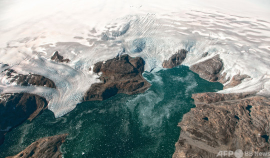
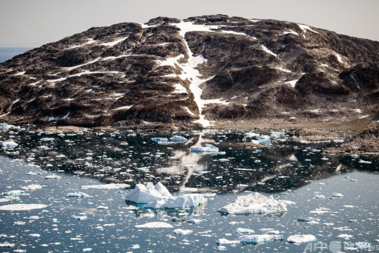

【グリーンランド3大氷河、最悪の筋書きよりも速いペースで融解する恐れ 研究】 - AFPBB News : https://www.afpbb.com/articles/-/3316474 : https://archive.is/wf6PO 2020年11月18日 4:56 発信地:パリ/フランス [ フランス ヨーロッパ ]
{{ 図版 1 : グリーンランド南東部の氷河。航空宇宙局(NASA)アース・オブザバトリー提供(2016年9月2日撮影、2016年9月22日提供、資料写真)。(c)AFP PHOTO / JEREMY HARBECK/NASA GODDARD }} {{ 図版 2 : グリーンランド南東部の氷河(2019年8月17日撮影、資料写真)。(c)Jonathan NACKSTRAND / AFP }} {{ 図版 3 : グリーンランド南東部の氷河(2019年8月17日撮影、資料写真)。(c)Jonathan NACKSTRAND / AFP }}
【11月18日 AFP】グリーンランドの3大氷河は、これまでの海水温上昇予測の最悪の筋書きより速いペースで融解する恐れがあるとの研究論文が17日、英科学誌ネイチャー・コミュニケーションズ(Nature Communications)に発表された。これらの氷河は、海面を約1.3メートル上昇させるのに十分な量の氷水を有する。
2000年までの海面上昇の主な要因には、氷河の融解の他、海水温の上昇による海水の膨張があった。だが過去20年ではグリーンランドと南極(Antarctica)を覆う氷床が海面上昇の最大かつ単独の要因となった。
論文によると、デンマークと英国の研究チームはグリーンランドのヤコブスハブン氷河(Jakobshavn Glacier)、カンゲルルススアーク氷河(Kangerlussuaq Glacier)、ヘルヘイム氷河(Helheim Glacier)それぞれから過去に消失した氷の量を、画像資料を含む一連のデータに基づき推計。1880~2012年にヤコブスハブン氷河から失われた氷の量は1兆5000億トン余り、1900~2012年にカンゲルルススアーク氷河とヘルヘイム氷河から失われた氷の量はそれぞれ1兆4000億トン、310億トンだったとの推計を明らかにした。研究チームによれば、これらの氷床の融解が8ミリ余りの海面上昇に寄与した。
国連(UN)の「気候変動に関する政府間パネル(IPCC)」が発表した、温暖化ガスの排出量が最も大きいシナリオ「RCP8.5」に基づいたモデルからは、この3大氷河の融解により、2100年までに海面が9.1から14.9ミリメートル上昇する可能性があることが示唆されている。しかし、研究チームはRCP8.5シナリオで予測されている気温の上昇幅は、20世紀中の上げ幅の4倍超だと指摘。3大氷河の融解量は、これまでの予測の3?4倍になる可能性があると述べ、この最悪のシナリオが「過小評価」されていると言明した。(c)AFP/Patrick GALEY
0 notes
