#nasa earth
Explore tagged Tumblr posts
agnesconaty · 10 months ago
Text
“Out of This World: Women in Space,” an International Women’s Day Event at Robinson Nature Center, Columbia, MD. 75 guests attended our hands-on, panel discussion and planetarium event tonight. We were an international panel from NASA/Goddard Space Flight Center: Samelys (Puerto Rico), Eleonora (Italy), and Agnes (Philippines).
Tumblr media Tumblr media Tumblr media Tumblr media Tumblr media
9 notes · View notes
eopederson2 · 2 years ago
Text
Tumblr media
Fog Down in the Valley
"The Willamette Valley in Oregon is rich with farms and orchards, home to 70 percent of the state’s population, and dotted with more than 500 wineries. But all of that can disappear under a blanket of white when the valley fills in with fog, as it has several times in recent weeks.
Fog is common in the region in the autumn and winter, as moist Pacific air moves inland, cools, and sinks into the vast valley between the Cascade Mountains and the Oregon Coast Range. As that air gives up its heat to the upper atmosphere, the layer near the surface becomes saturated and essentially forms clouds at ground level.
Such fog has been locked in the Willamette Valley for several long stretches in January and February 2022 due to temperature inversions, where warm air high in the atmosphere moved in over the cooler, denser air in the lowlands. Normally, temperatures are warmer at the land surface, cooling higher up in the sky. This allows for most of the rising air and pollutants to continue to disperse out into the atmosphere. But an inversion acts like an atmospheric “lid” that can trap moisture and air pollution in a valley for days.
On February 10, 2022, the Operational Land Imager-2 (OLI-2) on Landsat 9 acquired these natural- and false-color views of thick fog in the Willamette Valley. The false-color image was composed from shortwave infrared, near-infrared, and red light (OLI-2 bands 6-5-4). Scientists turn to these wavelengths to distinguish clouds (white and pink) from snow and ice (cyan).
Oregon has already seen at least three extended periods of valley fog in 2022, as observed by the Moderate Resolution Imaging Spectroradiometer (MODIS) on NASA’s Terra satellite from February 8-12, January 22-29, and January 14-17.
Fog is essentially a low-lying cloud composed of tiny water droplets suspended in the air. As nights lengthen with the season, the atmosphere has more time to cool down and approach the dew point—the temperature at which the air becomes saturated and water vapor condenses into fog. Since cold, moist air is denser than warm air, it sinks and drains into valleys, meaning fog develops there first. Many valleys like the Willamette also have rivers and streams that amplify the fog with a ready supply of moisture.
Fog can pose serious risks for drivers. Fog-related traffic accidents typically cause more deaths in the United States each year than other high-profile weather events like heat waves, tornadoes, and floods, according to data from the National Weather Service and the Federal Highway Administration. The foggiest parts of the United States, including Oregon, see dense fog at least 40 days per year.
NASA Earth Observatory images by Joshua Stevens, using Landsat data from the U.S. Geological Survey. Story by Michael Carlowicz and Adam Voiland.
View this area in EO Explorer
Oregon’s Willamette Valley had endured several long stretches of thick fog in January and February 2022 due to temperature inversions."
Source: NASA Earth Observatory
Remembering long drives to California in the distant past, Oregon was about 400 km of potential fog. This photo published last year brought back memories.
7 notes · View notes
titantheking · 2 years ago
Text
Tumblr media Tumblr media Tumblr media
3 notes · View notes
a-dream-seeking-light · 2 years ago
Photo
Tumblr media
NASA : Not your typical ice cube. 🧊 // Credit: NASA/Jeremy Harbeck
Although it is not uncommon to see icebergs with relatively straight edges, icebergs with two straight edges that converge into a right angle are less common. This rectangular iceberg was pictured in 2018 as part of Operation IceBridge, our longest-running aerial survey of polar ice. From 2009 to 2019, IceBridge flew planes loaded with special equipment over Earth’s polar regions to study sea ice, ice sheets, and glaciers to understand how Earth’s ice is changing. The rectangular iceberg appeared to be freshly calved from Larsen C, a large ice shelf extending from the Antarctic Peninsula. In July 2017, Larsen C also released the massive A68 iceberg, a chunk of ice about the size of the state of Delaware. IceBridge data like this help @NASAEarth scientists better understand the effects of climate change on Earth’s polar regions. Image description: A picture of sea ice extending to the horizon, taken from a low-flying aircraft. Where the ocean peeks through the ice is dark blue. Most of the ocean surface is covered in rough-looking white ice, thinner and thicker in some places, interspersed with sea ice icebergs. The icebergs have flat tops and sheer edges that rise above the sea ice. At this scope, perspective is hard to tell, but the icebergs rise far out of the water. In the center of the frame, an iceberg dominates. It is cut off to the left of the image, but the visible half looks almost perfectly rectangular, with smooth, straight edges and two precise right angles for corners.
#NASA #Iceberg #Antarctica #Ice #Ocean #Earth #ClimateChange #SeaIce
6 notes · View notes
nasa · 9 months ago
Text
Do You Love the Color of the Sun?
Tumblr media
Get dazzled by the true spectrum of solar beauty. From fiery reds to cool blues, explore the vibrant hues of the Sun in a mesmerizing color order. The images used to make this gradient come from our Solar Dynamics Observatory. Taken in a variety of wavelengths, they give scientists a wealth of data about the Sun. Don't miss the total solar eclipse crossing North America on April 8, 2024. (It's the last one for 20 years!) Set a reminder to watch with us.
37K notes · View notes
mizelaneus · 30 days ago
Text
0 notes
meteorologistaustenlonek · 4 months ago
Text
Intense blazes, including the #LineFire in Southern California, created “fire clouds” that matured into thunderstorms. #Landsat 8 captured a #pyrocumulus rising from the fire on Sept. 9. Active fires are marked in red." @NASAEarth
0 notes
without-ado · 5 months ago
Text
Tumblr media
Storm cloud over Texas l Laura Rowe NASA APOD
11K notes · View notes
zegalba · 8 months ago
Text
Tumblr media Tumblr media Tumblr media Tumblr media
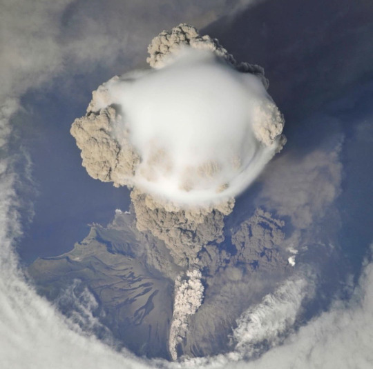
Volcano Eruptions seen from Space photos: NASA
13K notes · View notes
whatsthereinthename · 11 months ago
Text
Tumblr media
Mt. Vesuvius
The #Landsat 8 satellite 🛰️ was overhead when clouds parted for a glimpse of Mount #Vesuvius—one of the most dangerous volcanoes on Earth. https://go.nasa.gov/33jxDaz 🌋
1 note · View note
sakuraswordly · 1 year ago
Text
PACE’s two polarimeters - HARP2 and SPEXone - see rainbows everywhere they look. They will measure properties of light after interacting with clouds and aerosols, like dust, smoke, and pollution. The data collected will tell scientists about the types of aerosols and how they interact with clouds. Learn more about these two instruments as we get closer to PACE's launch in early 2024.
Learn more: go.nasa.gov/48gLsT1
0 notes
agnesconaty · 7 days ago
Text
Tumblr media Tumblr media Tumblr media Tumblr media Tumblr media Tumblr media Tumblr media Tumblr media Tumblr media Tumblr media Tumblr media Tumblr media Tumblr media Tumblr media Tumblr media Tumblr media Tumblr media Tumblr media Tumblr media Tumblr media
Thanks to Dr. Paul Newman, Chief Scientist of the Earth Sciences Division, and Dr. Thomas Frost Hanisco, Research Physical Scientist, for giving us a tour of the state-of-the-art instrumentation and lab of the Atmospheric Chemistry and Dynamics in Building 33, NASA/Goddard Space Flight Center, Greenbelt, MD.
0 notes
eopederson2 · 2 years ago
Text
Tumblr media Tumblr media
Shrinking Lake Albert, Oregon
Upper photo: 19 October 2022; Lower photo: 18 October 2002
"Every year, tens of thousands of birds flock to Lake Abert as they journey from parts of the Great Basin toward the Pacific flyway, a migration route that extends from Alaska and Canada, through California, to Mexico and South America. The shallow, salty lake in southern Oregon has long functioned like an all-you-can-eat buffet for many of these winged travelers. But the food source has become threatened in recent years.
Under normal circumstances, the lake’s water is too salty for fish. Instead, it supports large quantities of alkali flies and tiny crustaceans called brine shrimp (below), which have long provided a feast for several species of migrating birds. But the past few decades have been anything but normal for Lake Abert. The lake mostly dried up in 2014, 2015, 2021, and 2022 due to water withdrawals and dry weather, which caused the salinity of the lake’s remaining water to spike—becoming, at times, too high even for brine shrimp and flies.In order to improve understanding of why Abert is drying up, a team of researchers led by University of Maryland and NASA research scientist Dorothy Hall analyzed two decades of environmental data collected by the Terra satellite. They found that between 2001 and 2021, fewer days of snow cover and higher surface temperatures led to greater evaporation over Lake Abert. The research was recently published in Earth and Space Science.
“Lake Abert is largely fed by snowmelt emanating from the mountains to the west of the lake,” Hall said. “What we’re seeing in Lake Abert is worrying, and it is consistent with what you'd expect from this region because of climate warming.”
“We haven’t seen Lake Abert so low since the Dust Bowl,” added Ron Larson, a retired biologist with the U.S. Fish and Wildlife Service and one of the study’s coauthors. “There has been little or no inflow from the Chewaucan River, at the south end of the lake for the past two years.”
Researchers use a gauge on the eastern shore of the lake to track water levels and calculate the level and volume of the lake, but water levels fell below the lowest level of the gauge in 2019. To fill the gap in recent years, some researchers have relied on Landsatobservations of the lake’s areal extent to provide estimates of the remaining water volume.
The natural-color image at the top of the page (right) was captured by the Operational Land Imager (OLI) on Landsat 8 on October 18, 2022. A Landsat 7 image (left) shows the same area in October 2002, when water levels were at nearly the highest levels they have been during the past two decades.
Most of the water still present in the lake in October 2022 likely seeped down from a cluster of springs at the base of the cliffs that make up Abert Rim, a long fault scarp just east of the lake. As the volume of water stored in the lake declined, the water became saltier and more hospitable to blooms of certain types of salt-loving archaea, bacteria-like microbes that turn the water red. The photograph below, taken by Larson, shows red water in the parched lake on October 10, 2014.
Before the water dropped below the gauge, measurements indicated that the water level had dropped by roughly 15 feet (5 meters). What little water remains is roughly 1 to 2 feet (0.3 to 0.6 meters) deep. Water samples collected by Larson show that starting in 2020, the salinity of the water rose above 250 grams per liter (above 25 percent)—more than 10 times higher than salinities in the early 2000s. Brine shrimp and alkali flies in Lake Abert prefer salinities of 30 to 80 grams per liter and struggle to survive once salinity surpasses 200 grams per liter, according to Larson.
Without enough food in the lake, some species of birds are staying away. Ecological datacollected by volunteers for the East Cascades Audubon Society indicate that the number of birds visiting dropped by more than tenfold, from more than 250,000 per year a decade ago to 11,000 in 2021—the lowest number recorded in decades.
Among the birds seeing the biggest drop-offs are phalaropes. More than 100,000 Wilson’s phalaropes have come to the lake during past years, where they were known for a unique type of foraging that involved spinning on open water to stir up brine shrimp.
Since 2020, very few phalaropes have been seen at Lake Abert. Eared grebes, another species that requires relatively deep water to forage, have completely stopped coming as well. American avocets and willets, birds that can forage effectively in very shallow water, have shown more resilience and continue to arrive in some numbers. The photograph above shows a group of American avocets foraging in lake mudflats on November 13, 2020, when they were numerous.
Environmental data indicates that temperatures have risen, and less snow is falling in this part of Oregon, likely due to climate change. But water diversions are the key reason that the lake is drying up, according to research conducted by Johnnie Moore, an emeritus geoscience professor at the University of Montana. “Without water withdrawals, the lake would have maintained annual mean salinities mostly within the optimal range of brine shrimp and alkali fly growth,” said Moore.
Recent data from NASA’s OpenET project indicates that irrigated crops near the lake likely consume a large portion of the incoming water from the Chewaucan basin, according to a December 2022 analysis conducted by the Oregon Lakes Association. “We know the pressures on this lake are probably only going to get more intense in the coming years and decades,” said Moore. “The key thing is that we develop better management tools to ensure that this ecosystem continues to exist.”
NASA Earth Observatory images by Lauren Dauphin, using Landsat data from the U.S. Geological Survey. All photographs by Ron Larson. Story by Adam Voiland.
n.b. The original article includes several photos not reproduced here. The original article is linked above. Here is one of my photos of the shallow, saline lake taken in 2020, and here is a second one.
5 notes · View notes
spacewonder19 · 1 year ago
Text
Tumblr media Tumblr media Tumblr media
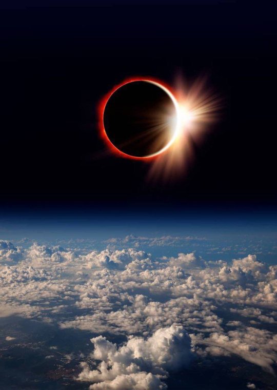
Ring of Fire in Cloudy Skies © Bryan Minear
15K notes · View notes
the-wolf-and-moon · 7 days ago
Text
Tumblr media Tumblr media Tumblr media
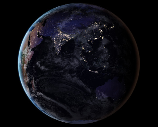
Earth at Night, Black Marble
3K notes · View notes
nasa · 9 months ago
Text
On Monday, April 8, 2024, there’ll be a total solar eclipse – and it’ll be the last one to cross North America for 20 years. Make sure you’re tuned in to our live broadcast for this exciting event: there’ll be views from along the path of totality, special guests, and plenty of science.
Make sure to follow us on Tumblr for your regular dose of space!
10K notes · View notes