#fan made map
Explore tagged Tumblr posts
Text
I often like to have reference materials open in other tabs while I'm watching shows. Wikis, maps, that kind of thing. For anything set in Exandria, this is, by far, my favorite map online:
It's zoomable! And annotated! And really pretty!
33 notes
·
View notes
Text
Im not in the fnaf sb fandom but i rlly like the bots there ,,,,,

#map bot#party bot#ranibwsprimklez#fnaf sb#fnaf security breach#fnaf fanart#fnaf#security breach#fnaf sb art#fnaf sb fanart#security breach fanart#security breach fnaf#doodle#doodles#artwork#ibispaint art#ibispaintapp#ibispaintdrawing#made in ibis paint#digital art#ibispaint drawing#ibispaintx#artists on tumblr#my art#fan art#fanart#art#digital artwork#digital drawing#fnaf art
206 notes
·
View notes
Text
I am done. I am calling this thing done. I know this isn't perfect. It could definitely be better. And I am by no means a draftsman. This is just me with my silly little screenshots trying to make sense of the layout. And now if I wanna draw/write about the inside of the cafe in the future for whatever reason. I have reference of where everything is at.
This was supposed to be a small project meant to give reference to others that didn't want to rely on screenshots alone. Or were like me and didn't have a way to access any fanmade maps. (I do not own gmod). But it's done, enjoy. With and without the screenshot references. As a treat.


If you guys had been following me for a while. You know just how much I had struggled working on this during my free time. However it became so much easier when I realized the square exterior was just a vague suggestion to how things would fit inside. That's for sure...
Anyhoo. Below the cut, you can listen to me crazily ramble on about the issues/inconsistencies I found while making this. But it's fine if you don't read and just want the references. The cut is just me specifically venting out all the slight insanity I felt making this.
Hey you're still here? Cool. Awesome.
So before I begin. Just to avoid any confusion. When indicating direction in the ramble below. I will be referring them in the way I oriented the map. For example, North is the entrance. South in the shelf selling bombs. Etc...
Main Floor/Cafe
1. The East wall has a door leading to the bathroom ("SMG4: The Inspection"). But it exists in a space that is not there.
2. The East wall also shows two windows on the outside. But only one window on the inside.
3. Both the backroom and hidden elevator are also are in a space that doesn't exist.
4. Speaking of the backroom. According to the concept sketch. There are windows on the West wall. Which, yes, should not exist. As we do not see any windows there from the inside. Unless they are being blocked by the shelves. Or those windows are just decorative stickers...
-Though I'm willing to give it a pass since we haven't actually seen that side of the wall in the show.
5. The front window's decal is not mirrored on the inside (this one is just a small nick pick. But something I couldn't unsee once I saw it).
Evil Lair/Basement
6. Past SMG3's bed (East side of room). There's a unknown area that turns off from the left of the entrance. With a solid wall immediately to the right. The tiles could mean it's a bathroom/kitchen area. But we don't see much more of it past the view from the doorway. I point this out because in "SMG4: You Used To Be Cool". There's a part where SMG3 shoots at the fireplace. Creating a hole and revealing a shower behind it.
-It's very confusing how you would get there. Because since there's a wall in the east room that could have lead there. The only other way to get there is the hypothetical space (shown in map) past the elevator to get to this shower. But again, this is not shown. So cannot be confirmed.
Anyways, that's it. That's the ramble. This project was more chaotic than I first thought it would be. And unless the official map comes out and I buy gmod to explore it. I am not touching this thing again.

#smg4#smg3#smg4 smg3#smg4 III's coffee n' bombs#rae rambles#I felt like I was going insane#a part of me wanted to get gmod just to look at fan maps#but as the name implies. They're fan made#and might not be accurate/miss details#so I relied on clips in videos#that was a mistake#i am just glad this imperfect map is finally done...#I spent too much time on this....
62 notes
·
View notes
Text

i cant for the life of me complete a drawing.. fuck my stupid baka lyfe
#postal#postal 2#postal dude#work in progress#fan art#my art#p2#i replayed postal 2 n i made him wear a cop outfit thru out monday#and i spent monday going to tora bora ... stupid!!!#basically i wasted my time going back n forth on the map bc most of the places arent open#lawl
56 notes
·
View notes
Text
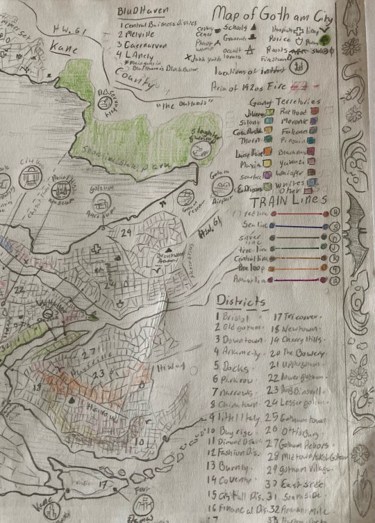
Gotham Map
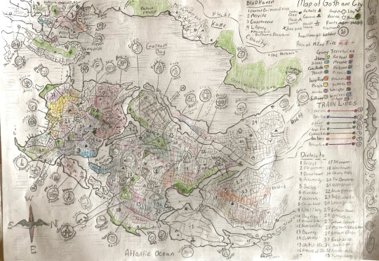
whoo! I'm not 100% done but if I don't stop now I will never stop.
over a month of work and I can now say I have completed my own map on Gotham!
as well as Bludhaven and summer set,
Bludhaven famously being the sister city of Gotham and primary haunt of Nightwing.
Summerset is a community between the two cursed cities that is just extrodinairaly normal. (I don't know what comic it is but I got the name from one I was looking at.) but here's the panel.
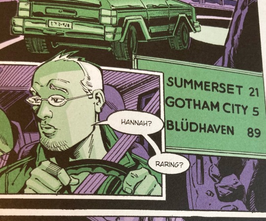
(No idea what issue this is from, I was browsing quickly through a large collection of older Batman comics and didn’t have time to sit and read it yet.)
So! Some Good Golly Gosh Context for the existence of this map. Before someone comes at me for non cannon accurate information and BS I'm about to pull.
This map was created for my use for a Transformative work I started toying with the idea of, that now has a hundred something chapters drafted (note: Drafted dose not mean written only one of those chapters is written and available to read. Dandelion puffs)
found here:
this map is a combination of the (mostly taken as) Cannon Map and the map that briefly appeared in "the Doom That Came to Gotham" film. the main inspiration for the Fanfic Idea. as well as things scavenged from Fannon and my own head cannon. some parts of it are also cobbled together from other bits of cannon, things such as the long halloween, Batman Year one, the one Nightwing comic I have read all the way through, a Batwoman and Catwoman comic, The Arkham Knight games, Actual maps of New Jersey (I mentioned that in my previous post about this map), The Harley Quinn Show, Joker (that movie) especially the subway map that apparently appeared in that film. Multiple Batman films... I'm not actually sure what batman movies I have watched just that one of them had Ra's Al Ghul and the scarecrow in them and featured the Narrows, and the 2022 batman film, and birds of prey. I really should have been keeping track of all the inspirations I used. I do that for Original works... but not for fan works as I'm not that used to making them or something.
this map operates with the assumption that the year is somewhere around 2020. and that in 1920 the city of Gotham suffered from a destructive fire. (see events of the doom of Gotham)
and in the late 1950s suffered from a catastrophic earthquake. (haven't read it but heard through the grapevine about Batman: no mans land. lots of the online maps reference it)
Also opperates under lovecraftian horror rules, because that's what this elderich horror AU...
the colors are a bit hard to see unfortunately, but they are mostly for my own use.
Gangs of Gotham:
Lime Green-Jokerz: they have close ties to the cult of the clown posse. operate mainly around the Amusement mile.
Scarlet red-Redhood: Headed by the mysterious Warlock Redhood. the gang is relatively young but rose to power quickly in 2005. most of Park Row (aka crime ally) and some of the surrounding areas are under the red hoods control.
they took their name from an earlier gang that was wiped out by the jokerz. The higher members of the gang jokingly refer to themselves as Red hood's merry men.
Red hood has a deep hatred for the Joker and Black mask considers him his primary rival.
Cyan Blue-Siloni: A Gotham grown mob, that consists of many different families that merged to become a singular mob.
Indigo-Moronei: Major rivals to the Falconies, they also got mostly destroyed in the same incident that destroyed their rival gang, but there where people to pick up the pieces
Gold-Cosa Nosta: a collection of families mobs originating from Sicily
Grey-Falconies: in the early 1940s the family was nearly destroyed following a series of incidents.
Dark green-Thorn: American Gangsters.
Colbalt blue-Penguin: Took their name after the moniker used by a professor at Gotham university. Rose to prominence in the 1920s during probation as the main go too if you wanted to set up a speak easy. under the leadership of Ms. Ollie "the penguin" Cobb. the gang was nearly taken over by the falcons in the 30s but after the destruction of the original falcon famaly managed to establish themselves. even operate as a half legitimate business a good portion of the time.
Orange-Lucky hare: collective term for the Irish mobs such as the Rileys, Sullivans, and so on.
Maroon-Black Mask: Run by the ambitious warlock Roman Sions Aka Black Mask. dominating he aria of the Bowery, He and the Red hood have a very violent Rivalry. He covet's Red hood's "red burial shroud." and territory. The black mask gang has ties to both the older sionis mob and the false face society.
yellow-Maxia: the gang Run by Maxie Zeus and the twelve olympians. the gang was founded by Greek immigrant Maxine Seuss. former Archeologist who went a bit mad after the death of her husband and daughter. she immigrated to the United States in 1922, after her American husband's death. her son Maximilian took over after his mother.
pale pink-Yakuza: are what they say on the Tin, operate both in Gotham and in Bludhaven.
purple-Scareface: one of the old Gaurd of street gangs. Is headed by “scareface” and his Vantriliquist. Scareface is a man who was opporating in Gotham back in the 1890s and 1910s but was hung by the place that later became Blackgate Penitentiary. He was also the man who ordered the death of Cyrus Gold and the subsiquent dumping of his body in Slaughter swamp.
brown-whispers: the collective name used for the Russian and Ukrainian mobs in the area. They operate partly out of the old subway tunnels. Mainly consists of the Ibansscas and Odessa gangs but there are others referred to by the collective term.
jade green-Evening Dragons: collective term for a good deal of gangs and organizations that have East Asian origins or influences.
this includes the East side dragons, Ghost Dragons, Golden dragons (might see where the name came from) the Lucky Hand Triad, Hanoi tan.
sky blue-Whites: A merger of the Black gaters gang and the Gangs run by Warren White "the shark".
pink-Other: a bunch of smaller gangs, gangs that are not organized or seen as being one of the largest players. gangs that are less well established or gangs that are extremely local to a certain neighborhood.
Intergang (metropolis baisses), street Demonz (local biker gang), the Mutants, sprang bridge soldiers, Burntly Town Massive, Decons, Escabedo Cartel, The stonewall Drug lords, Pealuan cartel, Skevers, Moon, and para military groups like Bane's and TYGER. and on rare occasions when Two-Face's Gang on the periodical basis that they become an issue.
Cults of Gotham:
I'll probably make some other post on a more in-depth chat about the cults of Gotham, the Occult comunity, and how they interact with the gangs, elite and citizens of Gotham. but that's not this post. here's a quick overview.
-Cult of Ghul: its leaders were destroyed in 1920. prior to this they had a lot of influence in Gotham as the guardians of the Lazarus pits that exist below the city. after the 1920s they lost most of thir influence, they still ave plenty of influence in other parts of the world with the surviving al ghul daughter.
-Court of Owls: been around forever want "what's best for Gotham" at least what they think is best, after the dismantling of the Cult of Ghul took over as the head honchos in the city.
-Baset's cats: Catwoman runs this cult, its a sect that broke off from a cult in New Orleans.
-Court of the yellow sign: They're a problem, and looking to make themselves everyones problem. very popular among the elite as it is a lot about pleasure and indulgence, and theatrics. work often and closely with the cult courts and the wounderlanders.
-She who Breaths: has a few other names, but is primairly a fertility and prosperity cult dedicated to Shub Niggurath and simular entities. they have a close and cordial relationship to the Green lady and is well respected among the Gotham and surrounding areas cults.
-Court of winter: the local fairy court.
-False face society: have a lot of pull and sway in the criminal underworld. also deal with the fay and vampire population of Gotham.
-Rail hoppers: A strange and loosely organized secret society whose worship revolves around the public transit system... people aren't really certain what thier deal is. but they're normally harmless.
-Pain: pain anyone? sort of your typical demon worshipers.
-Dead's Dawn Society: they have some weird beliefs around necromancy. the bats and birds is a decisive topic.
-Clown posse: people who believe that they can somehow appease the Entity known as the Joker. its a bit more complicated than that.
-Green Lady: Worshipers of the green.
-Bat and Bird watchers: one of the most yet least organized cults on the list. they aren't always considered a cult by the other cults in Gotham and has many facets to them. the
-Torch bearers: worshipers of Yeb and Nug. more so Nug than Yeb.
-Mad Society: AKA the brotherhood, a section of Gotham vampires worship here and seek to bring about the end of humanity and have vampires rule the world. or something along those lines.
also might want to create an army of werewolf women. this causes issues with the wounderlanders.
-wonder landers: in reality encompasses a great number of smaller cults who are all associated with the dreamland and dreamland deities in some way or another. but the main part style themselves after the book Alice in wonderland, the Avatar of the Elder God Hypnos. the current Batwoman's sister is a member.
-Triad: worshipers of the Earth Gods Lobon, Zo-Kalar and Tamash.
-Court of Dagon: Mostly dock workers and Deep ones who worship Dagon and Mother hydra.
-Court of truth: primarily worshipers of Aletheia, have some loose connections to the order of Saint Dumas.
-Court of stone: a group who seeks the caves of Solomon. spend a lot of time spelunking in the tunnels and cave systems of Gotham.
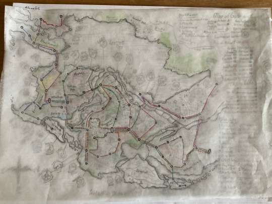
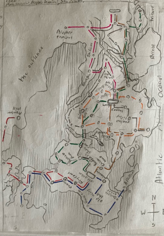
Stops on the Railway system.
H. Red Line: Redwall, Avalon hill, bludhaven port, the spine, old station, Melville station, Drawbridge station, Mealtide park, span bridge station, Gotham university, Cemetery hill, city council, Gold Gotham station.
8. Sea Line: Arkham, Arkham bridge park, Eastside, dockside, old city hall, memorial park, old Gotham, city council, Cemetery hill, Southside, span bridge station, lainly point station, Mealtide park, train yard.
0. Silver line: Steel st, Wayne Central, clock tower, city hall, central library, Roman st. Ottisburg, Park row, old Gotham
J. Tree line: Ash st. Oak st. clock tower. chinatown, Alder st. park row, Lemur park, spring st. cherry lane. Robinson park, Ottisburg, Roman st. Old Town
K. Central line: Wane central, clocktower, Penguin station, Millers Harbor, china town, old town.
9. the Loop: Wayne Central, Owl station, Burnley, Penguins station, Elliot Center, Precinct station, justice station,
A. Amusement line:Airport terminal, Kane street, Riverside, stadium, blackgate, Sheldon park, city hall, clock tower, Wayne central.
(some stations are not yet named, especially on the silver line, central line and tree line.)
the city also has an extensive Bus and Tram system, but if I drew that I may actually go crazy and try to bite someone's head off.
(stuffs mislabeled slightly on this map below but its accurate enough)
Parks
Robinson park- a park just outside of park row. its said to be the domain of some strange being known as poison ivy.
Memorial park-houses the 1920s fire memorial.
Wayne park- between North City park and Southside park. its located in the Financial district.
Sheldon park- the park next to the amusement mile. it could use some clean up, but is popular with teens and explores as it allows for an easy access to the cave systems of Gotham.
Southside park- houses the Gotham City zoo. and just outside of the flood area of the Cauldron.
North city Park- near the Gotham central hospital.
Lemmars park- in the cherry hills district. it was converted from the old Lemmars and other farm lands when the city expanded.
Arkham bridge Park- a rather large and wild park that takes up much of the eastern coast of Old Gotham Island.
Anders park- a small park south of Robinson park. its well known for cult activity.
I'll figure out the bridge situation some other time, just know that for this Span Bridge is the one that connects Bludhaven to Gotham.
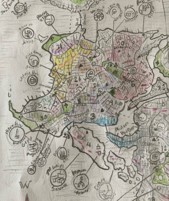
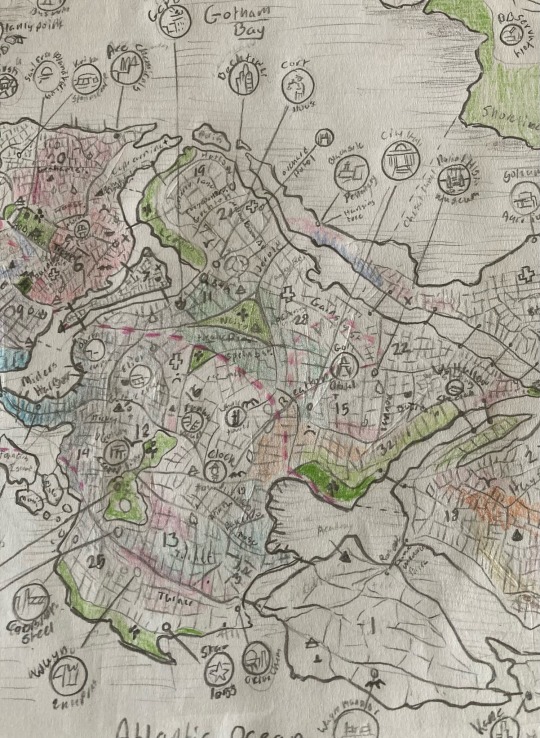
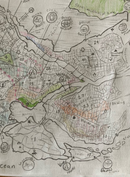
Districts.
1.Bristol- Island home to Gotham's Elite and Wealthy. the entire island essentially acts like a gated community. there is no metro trains to Bristol but there are a handful of bus stops. home to Gotham Academy a prestigious K-12 private school. Wayne manor and Drake manor are both located in Bristol.
2. Old Gotham- Mostly destroyed in the 1920s fire. the revitalization and rebuilding of the district left it with a very Art deco look.
home to the city council, the old city hall, and the Old Library.
3. Downtown-Built in a gothic revival style as an honor to the cities name and legacy. its history has been shifting with its demographic for years. still a rather populated and well lived in neighborhood, even if some businesses have moved to the financial district.
on the other side of the water to the area known as the Cauldron
4. Arkham City- Relatively unpopulated compared to other other parts of the city. is notable for its unique Victorian Gothic revival architecture. a lot of the structures are original to the area as Arkam Island survived relatively unscaved from the 1920s fire and the earthquake in the 1950s. the more populated parts of the island are heavily crowded and home to the failed "ark project" and the failed "wounder city." the most famous feature of this district is located on a small island just off the coast of the larger Arkham Island, and that is the infamous Arkham Asylum.
north of Arkham island are three islands of Founders, Bleake, Miagani Islands.
5. Docks- the main Port and Docking Area of Gotham. there are a lot of warehouses and industrial buildings in this area. also home to plenty of famous food stands and hole in the wall places like Mama Mathew's shrimp, as well as a good assortment of Bars and Dives, such as Sandyhood, Noonan's and Siren's whale (favorite bar of the Gotham City sirens).
the docks also hosts the Empty water tower that has Become one of Omen's Roosts. (note: Omen is Red Robin)
6. Parkrow- More well known as Crime Ally. once a prosperous neighberhood, it survived both the 20s fire and the 50's earthquake and fallout of both incidents. in the 80s, some of the area was redeveloped into "projects", though crime had already been on an upward spike since the 30s. some classic revival buildings survive from the cities heyday.
the old courthouse that hadn't been in use since 1903 was in this district as well as the famous monarch theater. and Leslie's Clinic.
the district has the cheapest renting all of Gotham but also a huge homeless population.
home to the Oldman building, the abandoned fire station, and is well known to be the haunt of the Red hood and the strange spirit known as the red wraith.
park row has its own community culture. you are likely to get stabbed.
7. Narrows- A narrow strip of land between the South (old Gotham) and North (new Gotham) islands. it is densely packed with buildings that frankly are not up to code. its just as densely packed with people. people make the best of the situation they find themselves in.second cheapest rent in the city, largely lawless.
jacks junkyard is a bit of lifeline in the area.
8. China Town- this districts architecture and open-air markets are what the it is famous for. Alongside its colorful nightlife (and we aren't talking bats!) Traditionaly played host to the cities east Asian immigrant communities. some parts of the districts are known as Korea-town or little Japan, there is also the statue street, that traditionally housed a lot of immigrants from India. the district is well known for having its own spin on the cities beloved gargoyles.
9. Little Italy- little Italy and the surrounding areas play host to many immigrant communities from the 1830s to 1950s. it rebuilt stronger and better both after the 1920s fire and the 1950s earthquake.
home to Maroni's pizzeria, leaty tile bar and the falcon statue.
10. Bay Ridge- another mainland district on the east side of the river.
11. Dimond District- the crystal, and glass facade that covers up much of the corruption of the city.
a popular district with locals and tourists both.
houses the main precinct of the GCPD, the County court house
12. Fashion district- An extension of the Dimond district but houses many more shop and places of entertainment. it's known for its 1950s futuristic appearance as it had to be rebuilt after the 1950s earthquake. has few fewer gargoyles compared to the rest of Gotham. relies on a series of flood dykes to keep from flooding. less prone to flooding compared to the poorer district of Coventry.
part of the area known as the cauldron.
13. Burnly-a large district that is a mix of residential, financial and industrial. it's a safeish neighborhood. though there's plenty of issues, but if you follow common sense rules for Gothem you should be fine... probably. its not as safe as some of the rich neighborhoods, or the mainland neighborhoods.
Gotham cathedral is in burnley, the watchtower is at the edge of the district.
14. Coventry- home to the Central library, the Elliot center, Iceberg lounge and millers harbor.
Millers harbor was created by the use of floodwalls and dykes in order to drain portions of the once marshy land and create a new part of gottam city. as a result most of millers harbor and coventry sits below sea level and is prone to flooding.
part of the area known as the cauldron.
15. City hall district- has a lot of crossover with the financial district and Dimond district. City hall, Gold hotel, National history museum are all located in this district.
16. Financial district- home to office buildings of most of Gothams companies. including the influencial Wayne industry. there are also several upscale apartment buildings in the area. Wayne tower is located here and the cities Subway system has its central station
the historic clock tower is towards the edge of the district.
17. Tricorner- a handful of small neighborhoods but the island is less populated, there is several industrial areas here, such as Kane industry having their plant in the area. Fort Damas is located on this island. its an inactive fort, and is now a historical site.
18. Newtown- a residential neighborhood with classic brick houses, different areas of knew town have different and rather recognizable styles.
19. Cherry hills- once upon the time used to be orchards. though there was space city earlier, the area was built up a lot on the 1970s. it is a pleasant area famous for the flooring trees that are in the area some still around from when the area was farmland. its also a testament to the fact that Gargoyles never go out of style in Gotham, even when the city dose brutalism. its a popular place especially during in spring. Bech tower is located in cherry hills.
20. the Bowery- the third cheapest place to live in in Gotham. the Bowery suffers a lot from the same issues that its neighboring district the Narrows and Park Row. Most buildings in the Bowery are Brick or stone. Gargoyles are quite popular here.
Black mask dominates the streets. Sal's Dinner and Hogan's ally Bar.
21. Upper Gotham-part of West Gotham
22. Lower gotham-part of West Gotham
23. Robbinsville-East side of Gotham river.
24. Lesser Gotham- the largest district on the new Jersey main land. it's practically its own city and was built up during the 1950s. its got its own police precinct (I feel like that's the wrong word) hospital, fire station and schools. probably one of the safer places to live in Gotham, but its still Gotham. people who move into Gotham from outside and can afford it tend to move here. largest issue is that
25. Gotham town- facing The Atlantic Ocean, its a relatively industrial area housing Star labs, Orion chem, Cobolpot steal and one branch of Wayne enterprise.
26. Ottisburg- A quite popular neighborhood, fox tech is located here.
27. Gotham Achors-located on the east bank of the River. A good deal of bridges that go into Gotham proper are here.
28. Midtown- part of West Gotham. location of Gotham general hospital.
29. Gotham village- part of the suburbs of Gotham, located in the west bank of Gotham River (seriously that's what it's called?) the Gotham Aquarium is found here.
30. East side- connected to the down town area, east side is a nebulous region that includes districts like the docks, millers harbor and down town.
31. South side- relatively industrial area. in recent years has seen revitalization in the form of parks and green spaces. relatively considered a tourist attraction as people from bludhaven will actually visit the area. its water front is relatively clean, and its proximity to Gotham university means that entertainment venues get a good deal of traffic.
the ferries to Gold Island and metropolis leave from that area.
gold island hosts the "statue of lady justice" that stands at the entrance to Gotham Bay.
within south side is the rust district. its still largely industrial and
32. Amusment Mile- Createdwith the intention of it being a boardwalk, it has several venues and pairs that fulfill the purpose. it is mostly safe during daylight hours, but should be avoided by anyone who's not looking to risk thier life at dawn or dusk, and especially it is ill advised to go there at night unless accompanied by a member of the clown posse, even then... the chance is high of encountering a certain clown prince of crime and his carnival of fools.
33. Harthrow Docks- part of East Gotham. A private docking area. was rebuilt in the 1920s. unlike millers harbor in coventry its a natural harbor.
((Also I welcome suggestions and idea on the "personality" of the different districts and locations that exist there and what the places look like.))
A huge thank you to @downtherabbittrail and @theredhoodedcryptid.
the red hooded cryptid gave suggestions on maps to use as resources.
I recommend checking out her cryptid batfam fic its quite nice.
meanwhile I stole (got permission from) Downtherabbittrail to use a lot of the street names they invented for one of their fics.
other street names are scavenged from other sources (cannons or cannons) as well as me just making stuff up.
Here are several closeups of the parts of the maps. Still illegible but it is what it is.
Here is a close up of bludhaven. It’s a lot more accurate to the maps I found online. especially compared to the maps I used for Gotham.
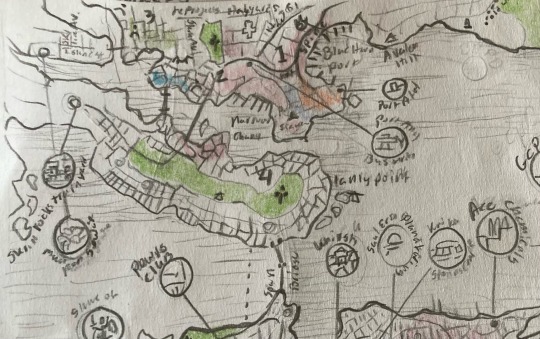
Things to know about bludhaven.
It’s the sister city to Gotham and is on the other side of Gotham Bay.
Bludhaven was founded as a port for whalers. It never saw as large success as its sister city. As the city of Gotham is practically a city state in some regards. The city of bludhaven survived in part thanks to its close relation with Gotham and its businesses.
As well as seeing a steady stream of crime in its waters since the very early days of the settlements existence. The Span bridge crossing over into bludhaven ascos the Gotham straight was built in 1878.
the overall architecture of the city is more modern, but a lot of Americana style brick houses and apartments are around.
Bludhaven districts- I can tell you less about these, as I'm having harder time finding info, might have something with bludhaven blowing up in cannon at some point?
Centeral business district- is what it says on the tin. houses both bludhaven's main hospital and the BHPD (bludhaven police department.)
2. Melville-the older parts of Bludhaven and Bailey's church. (had a goat named Bailey once, my uncle named her because she stared at him the same way his at the time GF did.)
Melville is also the place where Nightwing's apartment and Roost is.
3. Caernarvon- a more inland portion and houses a great deal of industrial areas as well as many places of worship.
4. LAnely- the peninsula its mainly a residential area
The Spine: is what Bludhaven has instead of a Main Street. It is the largest street in Bludhaven and Acts much like a Strip. with clubs, restaurants, hotels and other establishments. it has a reputation but most of the businesses are legitimate during daylight hours. some business or another is open on the Spine 24 hours of the day. the spine goes right along an industrial area of the Bludhaven port and officially ends just before Avalon Hill
The largest crime boss In Bludhaven was BlockBuster between the years 1989-2007
the largest cults in Bludhaven
-Blood hounds: a local vampire cult. they actually have quite a bit of bad blood with the Mad Society.
-Cormorants: An odd Cult who are the self-proclaimed guardians of Bludhaven. thier opinion on Nightwings presence is a bit split and has caused a schism in the cult.
-night doctors: bad news.
-bird watchers: made a jump over from Gotham when Nightwing moved cities. they also watch the activity of the cormorants
-Rail hoppers: because the Bludhaven Metro and the Gotham Metro connect to each other the Cult of the Rail Hoppers extended their reach with the reach of the public transit.
(There’s a good bit of lacking information online about Bludhaven when I went digging, which is surprising as the city has been in publication since 19, certainly it’s not Gotham that’s been a thing since 19, but still. )
Final note about this map is that it likely will have updates, especially as I get around to writing and growing more confident in my research on the whole thing.
#fantasy cartography#fan made#the doom that came to gotham#gotham#Gotham map#maxie zeus#black mask#court of owls#lovecraft inspired#lovecraftian#lovecraftian cults#king in yellow#black goat of the woods#shub niggurath#bludhaven#nightwing#red hood#black mask dc#red hood dc#long post
41 notes
·
View notes
Text
In the mood to de-Lionsgatolonize my mental map of Panem.
Since finding that super well-researched and reasoned fan-made map, which almost perfectly fits what I had initially imagined and adds so much more support, I decided I will go back and alter details in Katharsis to better reflect that than what is considered the "official" map.
#hunger games#katharsis#fanfic#Panem#map#honestly disappointed in myself for just accepting their thing and not standing by my headcanons#and grateful for the fans who made the good map for spelling out the reasoning#would probably go back and make those edits after I finish the story#I've always kept two north of the Capitol anyway it would mostly be for four with what I've written
11 notes
·
View notes
Text
Halo would be nothing without forgers I stg
#theres a new Cole Protocol themed firefight mode coming out that looks sick as fuck#so of course its fan made#they give them credit but stillllll#WHY DO FANS LOVE YOUR FRANCHISE MORE THAN YOUUUUUUU IT KILLS ME#if a map kicks ass in halo you can assume it was fan made but they wont incorporate them bc then theyd have to pay creators#AUGHHH MAKES ME SO MADDDD
8 notes
·
View notes
Text
i am way too lazy to actually search for this but since mbav takes place in Ontario i wanna know whether they're closer to Ottawa or Toronto. bc Erica mentions flying into the city in 1x01 and yes there are several cities in Ontario, but it would also make sense that she's referring to Toronto or Ottawa bc those are the two main cities in Ontario (Ottawa being the capital of Canada and Toronto being the capital of Ontario). but mainly i wanna know this bc in 1x07 Ethan's dad gets hockey tickets for Ethan and Benny and then they trade them off to the guys who tried to attack them so it would make more sense that it's a major NHL game instead of just like a local game or something bc of the hype around the tickets. so i need to know if the game was a Toronto Maple Leafs game or an Ottawa Senators game
#this is probably the most Canadian post i have ever made#but as a maple leafs fan i need to know#it would be so rad if they were also maple leafs fans#i know basically nothing about Ontario tbh#the last time i was ever in Ontario was when i was like 10#i also failed every assignment that had to do with maps in school#so geography is not my strong suit#but i desperately wanna know whether it was a senators game or a maple leafs game#mbav#my babysitter's a vampire#i also have so much homework to do so i am not allowing myself to do anything beyond posting this
23 notes
·
View notes
Text
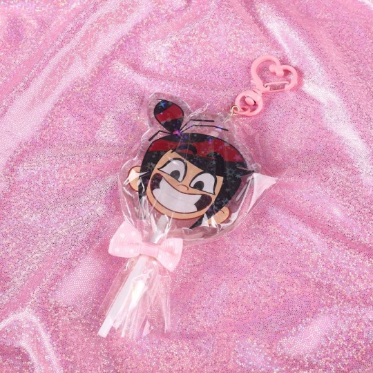
The Ghost and Molly McGee - Mollipop - Acrylic Lollipop Keychain Charm
#etsy#the ghost and molly mcgee#tgamm#molly mcgee#keychain#acrylic keychain#fan merch#disney#i wanted tgamm merch for so long but disney never made any :(#so i made my own!#fun fact this is a frame from the tgamm map part i did
15 notes
·
View notes
Text
Me and my mentally unstable boyfriend /j

#ranibwsprimklez#nightmarionne bot#map bot#doodle#fnaf sb#security breach fnaf#fnaf security breach#fnaf art#fnaf fanart#fnaf#security breach fanart#five nights at freddy's security breach#security breach#staff bot#ibispaint art#ibispaintapp#ibispaintdrawing#made in ibis paint#digital art#ibispaint drawing#ibispaint brush#ibispaintx#artwork#my art#artists on tumblr#fanart#fan art#art#digital artwork#digital drawing
150 notes
·
View notes
Text
Fallout Vaults Real Life Map (Maps) (Real Filming Locations)
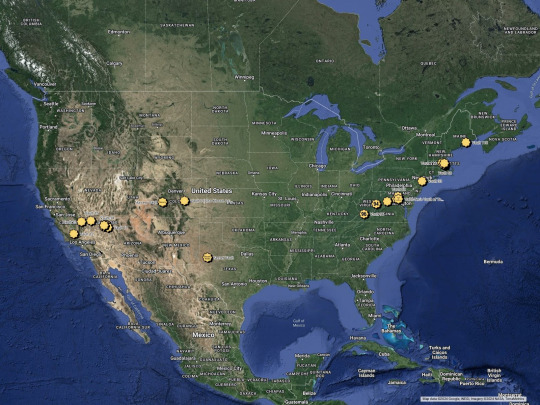
Map by @warrenwoodhouse. Here is my custom made real life map featuring all of the vaults from the entire @fallout franchise so far. More will be added over time, so check back frequently. Please let me know what you think in the comments and please make sure to add the hashtag #warrenwoodhouse when sharing or reblogging to your own blogs and websites. CLICK HERE to see the rest of the Fallout maps that I’ve created, including the ones that feature every single location from the entire franchise!
#warrenwoodhouse#gaming#2024#google maps#google my maps#googlemaps#map#maps#real life#fallout#fallout: new vegas#fallout 3#fallout 4#fallout tactics#fallout tv series#fallout shelter#fallout maps#fallout 2#fallout 76#fan made#fanmade#.map#realfilminglocations#fallout prime#fallout tv show#fallout series#Fallout (TV Series) (Amazon Prime Original Series)#fallout2#fallout3#falloutnewvegas
26 notes
·
View notes
Text
WHAT THE FUCCCKKK WHY DID IT END LIKE THAT??? 😭😭😭😭😭😭😭😭
#…..yeah u alrwady know whats up#the amazing digital circus#spoilers in the next tags now ofc#ragatha…….. my dear ragatha trying her absolute fucking hardest to cheer pomni up#we all saw it coming a mile away bless her soul#and the entire scene under the map#pomni immediately latching onto gummy goo’s misery and being so soft and comforting made me want to THROW UP AND BAWL MY EYES OUT#bc….. rags doesnt know that if she just stopped trying to act overly positive and push everything that happened to her aside#and instead was real with her and tried to find ways they felt similar about being trapped#she would have been so much more successful in helping her like she wanted#FUUUCKKK!!!!!!!!#and the FUCKING FUNERAL FOR KAUFMO?????#jaw dropped when zooble came in saying that#that whole fucking end scene makes me want to throw up and BAWL#THE HANDS REACHING OUT TO POMNI AND CATCHING HER#OUGHDHFHFHHHH#the ragapom enjoyers have been fed.#btw#i have been fed#rewatching throwing up shitting and crying#two big rips to gummy goo and gangles happy mask only being on for 4 minutes and 7 seconds (yeah i checked)#anyway ragatha and pomnis voices are so nice inlove women#and jax showing an emotion for a 000000.00001th of a frame#the jax fans are gonna go crazy over that i can tell#yall can have him but also that facial expression couldve been abt queenie just my hunch tho#SPEAKING OF kinger having a split second of clarity talkin to rags in that scene?#he was absolutely fatherly to her when she first appeared#wish we could see this so bad#time to be normal now alr buhbye#slaps a lesbian sticker on ragatha for doing like 4 finger guns and flirting with the queen
23 notes
·
View notes
Text
let me be annoying and show u guys what i mean about CSGO 2 Inferno map, like Im not joking when I say I can LIVE in this place iTS SO COZY AND PRETTY


edit:
also worth mentioning is both csgo and csgo2 are free, and they can run even on potato laptops (just bump the graphics down) So if you ever want to get some references or idea for backgrounds and some combat stuff, you know where to go! You can basically make a lobby with just bots then kick em out, fly around, defy physics and get a bunch of photo. There's also those maps out there that people download to practice their aims and stuff which looks like shooting ranges and stuff! this is how I get materials for my OC haha so ye!! just be mindful in actual matchmaking cuz yk how it is with these sort of games where toxicity is at all time high lmao
#you bet your ass i did spent hours looking at every nooks and crenies in this map#the new map is so much more brighter and town like#altho i prefer old csgo's banana and pond area#the revamped one made it more deserted#HUGE FAN of those red flower trees#i used to play csgo yes SKDJGHLKZH#should you play it? no absolutely not esp if you're a girl LOL#gummmyspeaks
10 notes
·
View notes
Text
maps of the island in Lost
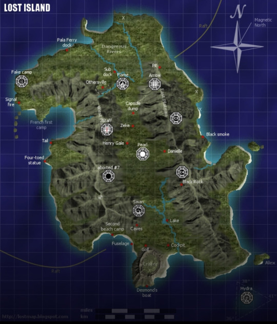
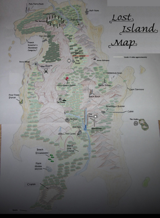
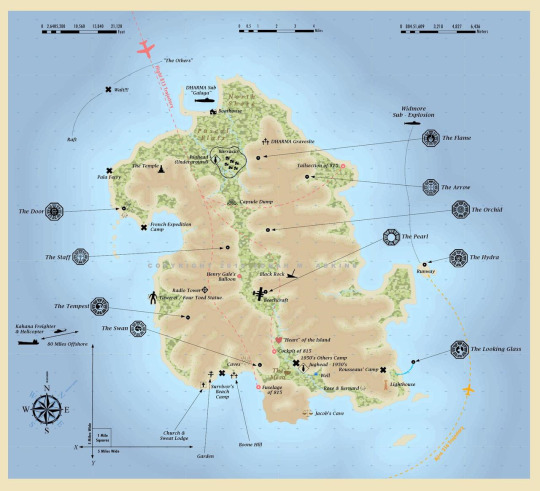
so, I got really into map making again (I hand draw maps sometimes. If you wanna see them, let me know.) and for funsies I wanted to see what maps people made of the island from the Lost tv show. These three are my favorite. of course, all of them have the same or at least a similar shape to the irl island of O’ahu (part of Hawai’i) since the show was filmed there.
you can check out these three fan-made maps as well as others on the Lostpedia site (which is a godsend for anything and everything Lost related)
12 notes
·
View notes
Text
Warmth [Where We Belong]
youtube
youtube
Money is tight this month, so I decided to sell 15 copies of the full-resolution fan-art image with no watermark for personal use. If you're interested in purchasing one, the minimum amount is 1 USD. It would be a great help. Thank you. 💜 https://ko-fi.com/s/ba1b359eb6
Original characters by Alan Becker
WIP Post

15 notes
·
View notes
Text
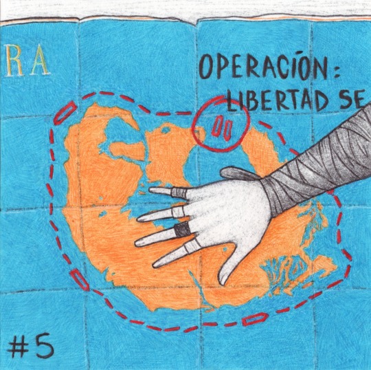
Inktober 2023, Day 5: Map.
Very old and made for tourists… but still useful.
#the scanner made this one look better actually#so apparently it’s spelled ‘operación’ but on the in-game map it really looks like they wrote ‘operacíon’#I drew a compromise#inktober#inktober 2023#inktober2023#far cry 6#clara garcía#clara garcia#yara#isla santuario#ubisoft#map#my art#fan art#traditional art
25 notes
·
View notes