#OldMap
Explore tagged Tumblr posts
Visit Tumblr Blog
Explore Tumblr blogs with no restrictions, modern design and the best experience.
Last Seen Tumblr Blogs


Fun Fact
Tumblr has 16.74 million mobile monthly users in the US.
Text
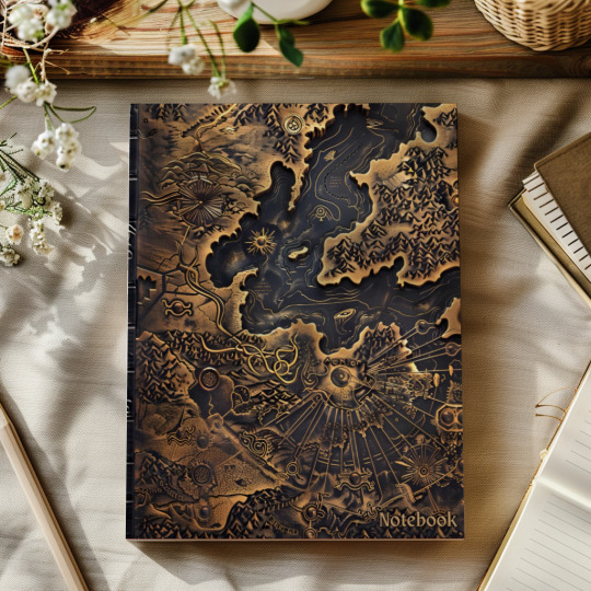
Notebook: Lined Pages with Decoration
Are you looking for a new notebook? Do you like old books? If yes, this notebook will be perfect for you. It contains 120 double-sided lined pages. Each page is decorated with a geographical motif to bring uniqueness to the notebook. The cover is stylized on an old book and will stand out among others. This notebook will be perfect for writing notes, thoughts, or dreams.
#amazon#notebook#diary#journal#planner#school#college#student#teacher#work#study#learn#lesson#oldbook#map#oldmap#fantasy#compass#magic#geography#antique#create#imagine#creativity#imagination#dream#thought#idea#plan#notes
1 note
·
View note
Text
Stamford Raffles
Sir Stamford Raffles, born in 1781, was a British statesman best known for founding modern Singapore. In 1819, Raffles arrived in Singapore, recognizing its strategic importance as a trading post. Negotiating with local rulers, he established a British port, transforming the island into a vital hub for commerce and trade.
During his time in Singapore, Raffles implemented policies that promoted free trade, attracting merchants from around the world. He laid out plans for the city's development, emphasizing urban planning and education. Raffles' vision and administrative skills were crucial in setting the foundation for Singapore's growth into a major global port.
Raffles left Singapore in 1824, but his legacy endures. Often celebrated as the father of modern Singapore, his contributions paved the way for the island's transformation into a thriving metropolis.
Axel Laniez


1 note
·
View note
Text
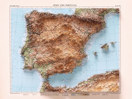
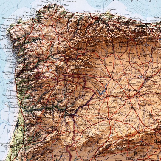
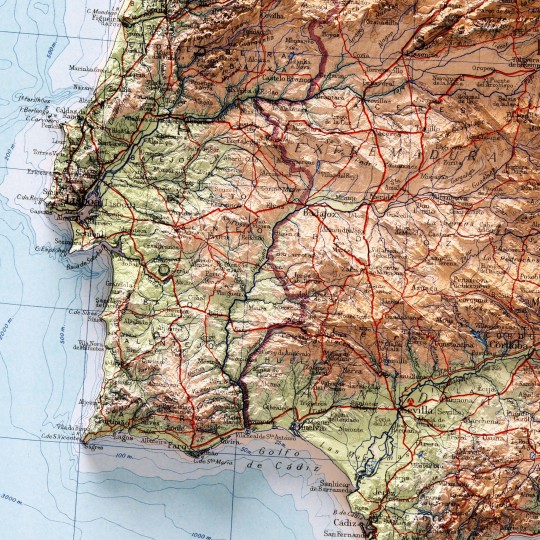
We realised there were plenty of maps on Spain, Portugal and more specific places in those states, but we realised there was one big absentee: a map covering the entire Iberian peninsula, so here it is.
This map was prepared by J. Bartholomew and published in The Times Atlas of the World. Mid-Century Edition by Houghton Mifflin Co. in 1956.
If you like our work, want to see our daily updates (or want to say hello to our studio), consider to follow our Instagram or Twitter account. Otherwise if are interested in our prints or have a custom request check our shop.
#iberian#iberianpeninsula#spain#espa#madrid#travel#portugal#lisboa#porto#europe#iberia#map#geography#cartography#mapart#history#atlas#antiquemaps#oldmaps#geospatial#vintagemaps#topography#shadedrelief
7 notes
·
View notes
Text
Antique Compass & Faded Map 🧭 Historical AI Art
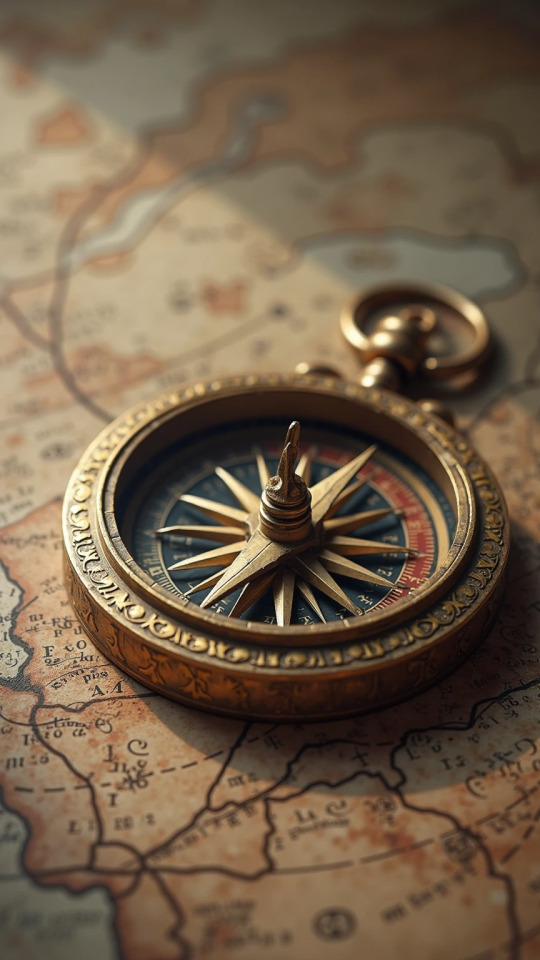
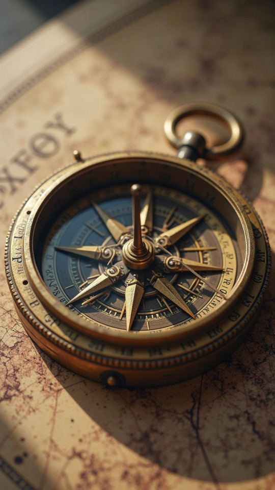
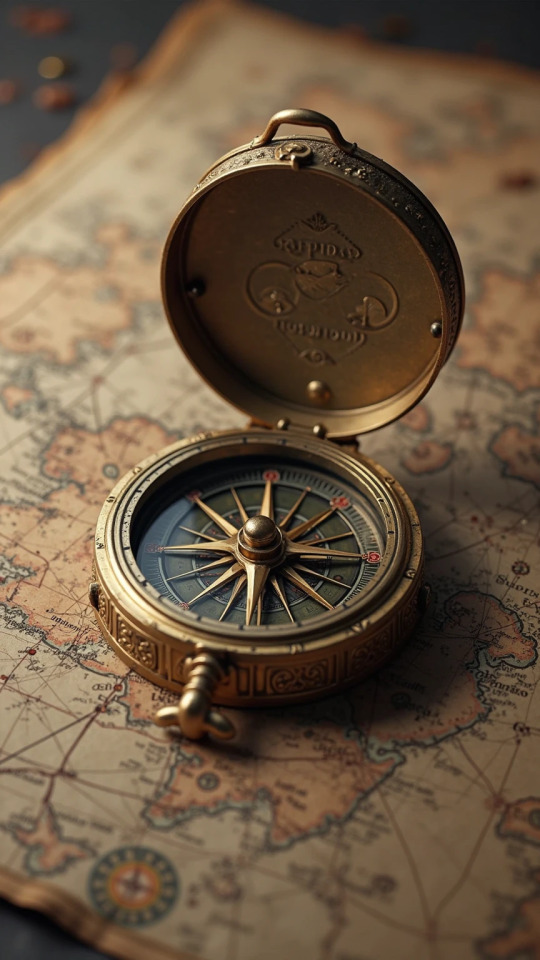
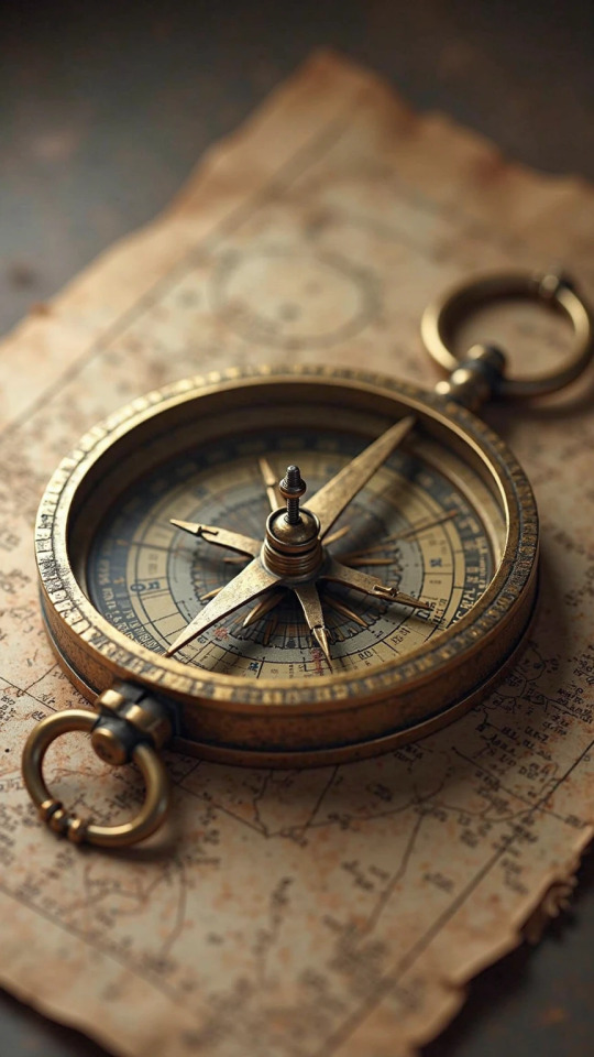
A true relic, reimagined. 🧭 This highly detailed AI art depicts an antique compass with intricate brass mechanisms and a delicate, faded map as its background. The soft, diffused light and aged texture lend it a perfect vintage aesthetic, making it feel incredibly realistic. Uncover the full prompt behind this historical artifact.
#Antique#Compass#HistoricalArt#Vintage#AIArt#DigitalCreation#Realistic#AgedTexture#Brass#OldMaps#ArtPrompt#Timepiece#Exploration#Heritage#DetailedArt
0 notes
Text
AI and Historical Maps Unite to Locate Abandoned Oil Wells

Source: newscenter.lbl.gov
Category: News
The Hidden Legacy of Abandoned Wells
AI and Historical Maps are proving to be a game-changer in identifying and addressing the environmental hazards posed by undocumented orphaned wells (UOWs). The United States is grappling with the environmental consequences of its long history of oil and gas extraction, particularly in the form of undocumented orphaned wells (UOWs). These abandoned wells, many of which have been left without a responsible operator or official documentation, pose significant threats to both the environment and public health. From methane emissions that accelerate climate change to the contamination of water supplies with toxic substances, the dangers are clear. Yet, pinpointing the locations of these hidden relics, estimated to number between 310,000 and 800,000, has long been a daunting challenge.
Combining AI and Historical Maps to Find UOWs
Recent advancements in artificial intelligence (AI) have provided a promising solution to the problem of locating orphaned wells. In a groundbreaking project, researchers have turned to historical maps, some dating back as far as 1884, to help identify the sites of former oil and gas operations. These topographic maps, digitized by the U.S. Geological Survey (USGS), offer valuable insights into early drilling activities. The challenge, however, is sorting through vast archives of these old maps.
Fabio Ciulla, a postdoctoral fellow at the Lawrence Berkeley National Laboratory, has been instrumental in leveraging AI to analyze these maps. By using a U-Net convolutional neural network, an AI algorithm designed to recognize oil well symbols, researchers can now identify potential UOW locations with remarkable accuracy. The system was trained on manually labeled maps and applied to regions with significant oil production histories, such as Kern and Los Angeles counties in California, and Osage and Oklahoma counties in Oklahoma. In these areas, the AI identified over 1,300 potential orphaned wells.
Verifying AI Findings and Expanding Detection Efforts
While AI has proven effective in identifying potential well sites, verification remains a critical step. Researchers use satellite images and historical aerial photos to search for visual signs of abandoned wells, such as pump jacks or storage tanks. In cases where surface evidence is lacking, magnetometers are deployed to detect buried metal well casings. The accuracy of the AI is impressive, with wells being located within an average of 10 meters of their predicted positions.
AI and Historical Maps represent a significant leap over traditional approaches, such as manual record searches or on-the-ground surveys, which are often slow and geographically limited. However, the project doesn’t stop at map analysis. As part of the Consortium Advancing Technology for Assessment of Lost Oil & Gas Wells (CATALOG), the effort includes a range of advanced tools, such as drones equipped with methane sensors and magnetometers, to detect leaks and locate buried wells. Additionally, researchers are working on cost-effective solutions to monitor methane emissions, an essential step in mitigating the environmental impact of orphaned wells.
The CATALOG initiative is also tapping into citizen science, encouraging individuals to use smartphone magnetometers to help locate abandoned wells. This crowdsourced approach expands the reach of detection technologies, providing valuable data while complementing professional surveys.
A Cleaner Future Through Collaboration and Innovation
The AI and Historical Maps-driven efforts spearheaded by CATALOG offer a glimmer of hope in addressing the legacy of America’s oil boom. By integrating historical data with modern technology, the project not only improves the accuracy of orphaned well detection but also lays the groundwork for more effective remediation. Collaboration with local communities, including Native American tribes and environmental agencies, is crucial to the initiative’s success. As researchers continue to refine their techniques, they are not only tackling the immediate environmental risks posed by orphaned wells but also contributing to broader climate mitigation efforts.
As Sebastien Biraud, a scientist at Berkeley Lab, notes, finding solutions to limit emissions is essential for the future. By combining AI, cutting-edge sensors, and community involvement, researchers are uncovering a hidden legacy of the nation’s energy history while paving the way for a cleaner and safer future.
0 notes
Text


A personal favorite. Presenting the El Viejo Continente Salomon wood cigar box. Painted a shining gold, it's great for modern day cartographers, charting their own course! It even comes with removable dividers that are great for art and/or office supplies and much more! 🗺⛵
@ebay
0 notes
Text


EuroCarto2024
მიმდინარე წლის 8-11 სექტემბერს ავსტრიის დედაქალაქ ვენაში, საერთაშორისო კარტოგრაფიული ასოციაციის ეგიდით, გაიმართა საერთაშორისო სამეცნიერო კონფერენცია EuroCarto2024. კონფერენციას უმასპინძლა ვენის ტექნიკურმა უნივერსიტეტმა. სამეცნიერო ფორუმის ორგანიზატორები იყვნენ: საერთაშორისო კარტოგრაფიული ასოციაცია (ICA), ბრიტანეთის კარტოგრაფიული საზოგადოება (British Cartographyc Societ), ჩეხეთის კარტოგრაფიული საზოგადოება (Česká kartografická společnost). კონფერენციის საორგანიზაციო კომიტეტის ხელმძღვანელი იყო საერთაშორისო კარტოგრაფიული ასოციაციის პრეზიდენტი, ვენის ტექნიკური უნივერსიტეტის პროფესორი, გეორგ გარტნერი. კონფერენციაზე მუშაობდა 20 თემატური სესია: კარტოთეორია, დიზაინი, გეოვიზუალიზაცია, მდგრადობა და კარტოგრაფია, CartoAI, რუკების გამოყენება, გენერალიზაცია, განათლება, ატლასები, თემატური კარტოგრაფია, კარტოგრაფია კატასტროფებსა და მენეჯმენტში, ანალიზი, ისტორია, VGI და კარტოგრაფია, მდებარეობაზე დაფუძნებული სერვისები, შემეცნებითი კარტოგრაფია, Web კარტოგრაფია, აპლიკაციები, ხელოვნება, დიზაინი და კარტოგრაფია, ტოპონიმიკა და ტოპოგრაფია. კონფერენციის მუშაობაში მონაწილეობდა მსოფლიოს 50 ქვეყნის 350 მეცნიერი. კონფერენციის მუშაობაში მონაწილეობა მიიღო ივანე ჯავახიშვილის სახელობის თბილისის სახელმწიფო უნივერსიტეტის მეცნიერთა 6 წევრიანმა ჯგუფმა ასოცირებული პროფესორის, ალექსანდრე ასლანიკაშვილის სახელობის საქართველოს კარტოგრაფთა ასოციაციის პრეზიდენტის, თენგიზ გორდეზიანის ხელმძღვანელობით (დელეგაციის წევრები: თენგიზ გორდეზიანი, გოჩა გუძუაძე, გიორგი დვალაშვილი, მანანა შარაშენიძე, თინათინ ნანობაშვილი და რომან კუმლაძე). კონფერენციას სტუმრის სტატუსით ესწრებოდა ასოცირებული პროფესორი რობერტ მაღლაკელიძე. ქართული დელეგაციის წარმომადგენლებმა კონფერენციაზე წარადგინეს 7 პრეზენტაცია (2 ზეპირი მოხსენება და 5 სასტენდო მოხსენება). ქართველ მეცნიერთა მოხსენებები ძირითადად შეეხებოდა კარტოგრაფიის ისეთ მიმართულებებს, როგორებიცაა: კარტოგრაფიის თეორია, ატლასური კარტოგრაფია და თემატური კარტოგრაფია. ქართველ მეცნიერთა ჯგუფი მომავალი თანამშრომლობისა და განვითარების ნიშნით დატვირთულნი დაბრუნდნენ სამშობლოში. წარმატებები ვუსურვოთ ქართულ კარტოგრაფიულ მეცნიერებას, რომელსაც ძალიან მდიდარი ტრადიციები გააჩნია!!!
ზუსტ და საბუნებისმეტყველო მეცნიერებათა ფაკულტეტის, გეოგრაფიის დეპარტამენტის ასოცირებული პროფესორი, ალექსანდრე ასლანიკაშვილის სახელობის საქართველოს კარტოგრაფთა ასოციაციის პრეზიდენტი, თენგიზ გორდეზიანი
#cartography#map#maps#geography#mapping#topography#cartografia#history#gis#mapmaking#antiquemaps#world#oldmaps#mapmaker#travel#cartographyart#cartographer
1 note
·
View note
Link
OldMaps Online : une carte interactive incroyable pour découvrir l'histoire du monde Quand j'ai commencé à écrire sur Byothe...
0 notes
Text

Serendipity . 17 December 2025 . Old Time GPS . 1675
Description The Road From LONDON to the LANDS END Commencing at the Standard in Cornhill and Extending to Senan in Cornwall
Date 1675
Source http://www.priddyshard.com/history.htm#oldmaps
Author John Ogilby (1600–1676)
0 notes

Text
#地図 塗り絵。
地図が好きでモレスキンによく描いています。
3年前、それをご覧になったお客様から「地図の塗り絵をしたい」というお声をいただき、試してみたら、これがとっても楽しい。
ポストカードサイズだと、パーツが小さくて大変かな、と思っていたら、そうでもないんですね。
皆さん楽しんでくださるの��、今年で3回目の地図塗り絵です。
どれも基本的なパーツは同じ何ですが、微妙に変えると物語が生まれます。
古地図風にしてもいいですし、絵地図にしてもOK。
楽しみ方はいろいろ。
いつもは下絵は1枚ですが、地図のときは古地図の雰囲気が出しやすい鹿子色の紙もおつけしています。
先日のオンライン教室で、ダーウェントアーチストのバーントアンバー1色で塗ったら、とっても怪しげな雰囲気になりました(笑)
2月の教室は、12日と13日。モチーフはクリスマスローズです。
#art #coloredpencil #fabercastell #polychromos #色鉛筆 #ダーウェントアーチスト #1日1絵 #イラストグラム #今日何描こう #今日何描いた #絵を描く暮らし #map #塗り絵教室 #oldmaps

0 notes
Text
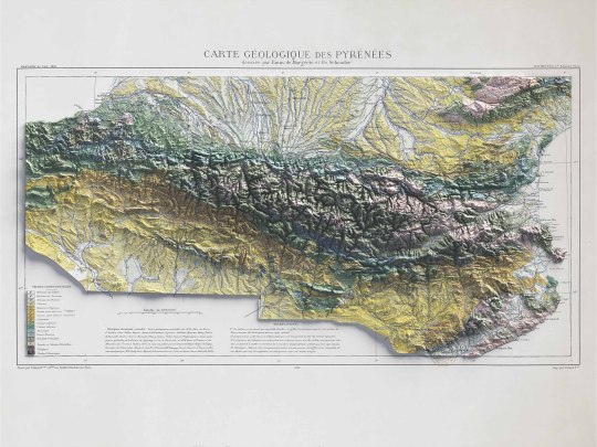
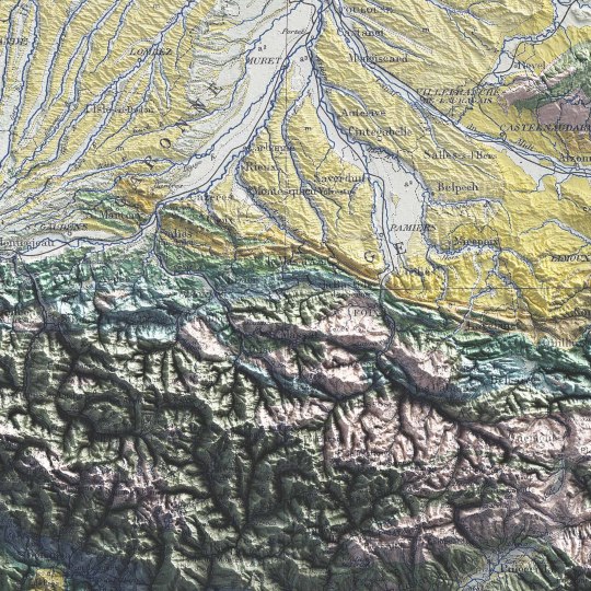
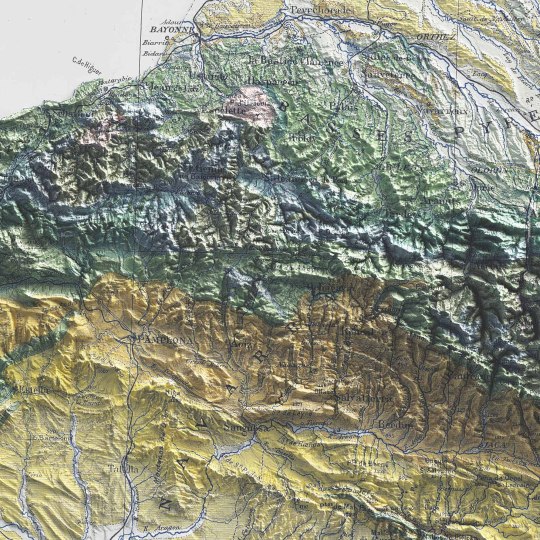
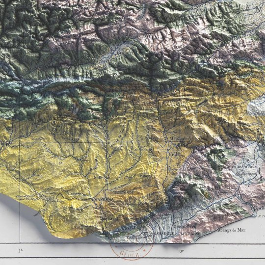
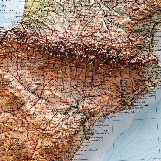
Pyrenees, shaded relief geological map.
🗺️ 𝗠𝗔𝗣 𝗜𝗡𝗙𝗢
Carte géologique des Pyrénées / dressée par Emm. de Margerie ; et Fr. Schrader, Annuaire du C. A. F. 1891, Hachette (Paris). Source: Gallica.
If you like our work, want to see our daily updates (or want to say hello to our studio), consider to follow our Instagram or Twitter account. Otherwise if are interested in our prints or have a custom request check our shop.
#cartography#maps#PyreneesMap#VintageMaps#ShadedRelief#CartographyArt#HistoricalMaps#MapLovers#GeographyArt#VintageCartography#MountainMaps#ReliefMapping#MapCollection#OldMaps#19thCenturyMaps#MapAesthetics#TopoMaps
3 notes
·
View notes
Photo
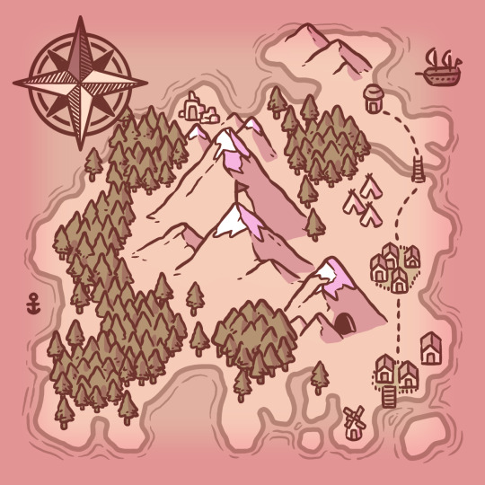
Is it map Monday already? 🗺️
#map#mapmonday#fantasy map#fantasy#dnd#dnd e5#dnd map#dnd ideas#island#floating island#island map#oldmap#gameart#game design#Game Assets#mountains#drawing#digital art#Digital Illustration#digital drawing#original drawing#original content#original work#penzilla#story world
64 notes
·
View notes
Photo

Six days late via FedEx and missing the Con completely, my “Northern Lands: Imperial map” from the Witcher Universe map order finally came in… and they did a great job!. . This is available in my shop as a large poster print, link in my bio! . Traditional Gouache and ink on stained watercolor paper, with digital coloring via PS CS4 and Wacom Intuos Pro tablet. . . . . Check out my Patreon! : https://www.patreon.com/JaredBlando . . #witcher #witcher3 #inks #inksketch #thewitcher #Jaredblando #cartographer #mapmaker #thewitchernetflix #ghouache #traditionalart #oldmap #dndmaps #ttrpgs #illustrationartists #oldmaps #artistofinstagram #map #cartography #painting #fantasyart #artist #magic #Westernlands #worldmap #watercolor #fantasy #kaermorhen #poster #rosecitycomiccon https://www.instagram.com/p/CT0Ek0MB8hM/?utm_medium=tumblr
#witcher#witcher3#inks#inksketch#thewitcher#jaredblando#cartographer#mapmaker#thewitchernetflix#ghouache#traditionalart#oldmap#dndmaps#ttrpgs#illustrationartists#oldmaps#artistofinstagram#map#cartography#painting#fantasyart#artist#magic#westernlands#worldmap#watercolor#fantasy#kaermorhen#poster#rosecitycomiccon
2 notes
·
View notes