#NASAEarth
Explore tagged Tumblr posts
Photo


In Spain, a drought turns the world’s largest olive oil producing region brown.
NASA’s Terra satellite shows where green vegetation in May 2022 (top) turned brown by May 2023 (bottom). The drought dried up reservoirs, parched olive groves, and led to water restrictions.
by @NASAEarth
250 notes
·
View notes
Photo
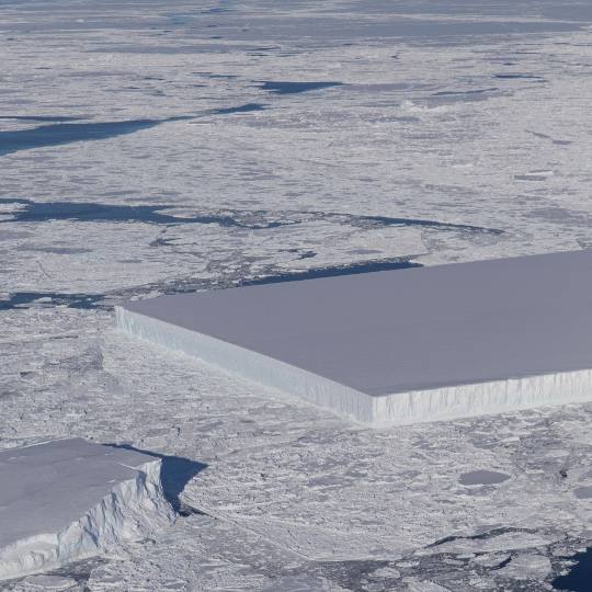
NASA : Not your typical ice cube. 🧊 // Credit: NASA/Jeremy Harbeck
Although it is not uncommon to see icebergs with relatively straight edges, icebergs with two straight edges that converge into a right angle are less common. This rectangular iceberg was pictured in 2018 as part of Operation IceBridge, our longest-running aerial survey of polar ice. From 2009 to 2019, IceBridge flew planes loaded with special equipment over Earth’s polar regions to study sea ice, ice sheets, and glaciers to understand how Earth’s ice is changing. The rectangular iceberg appeared to be freshly calved from Larsen C, a large ice shelf extending from the Antarctic Peninsula. In July 2017, Larsen C also released the massive A68 iceberg, a chunk of ice about the size of the state of Delaware. IceBridge data like this help @NASAEarth scientists better understand the effects of climate change on Earth’s polar regions. Image description: A picture of sea ice extending to the horizon, taken from a low-flying aircraft. Where the ocean peeks through the ice is dark blue. Most of the ocean surface is covered in rough-looking white ice, thinner and thicker in some places, interspersed with sea ice icebergs. The icebergs have flat tops and sheer edges that rise above the sea ice. At this scope, perspective is hard to tell, but the icebergs rise far out of the water. In the center of the frame, an iceberg dominates. It is cut off to the left of the image, but the visible half looks almost perfectly rectangular, with smooth, straight edges and two precise right angles for corners.
#NASA #Iceberg #Antarctica #Ice #Ocean #Earth #ClimateChange #SeaIce
#nasa#iceberg#antarctica#ice#ocean#earth#climate change#sea ice#operation icebridge#jeremy harbeck#elements#photography#science#nasaearth#nasa earth
6 notes
·
View notes
Text


nasaearth on IG
1 note
·
View note
Text
youtube
0 notes
Text


North America from the ISS l NASAEarth
#nasa#earth#space#north america#astrophotography#astronomy#sky#planets#stars#solar system#galaxy#night#universe#iss#international space station
1K notes
·
View notes
Text

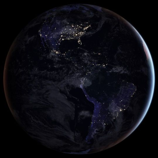
by nasaearth
#nasa#planet earth#earth#space#astrophotography#astronomy#astrophysics#science#curators on tumblr#up
3K notes
·
View notes
Photo


Our Home © NASAEarth, Apollo 8
#nasa#earth#space#astrophotography#planet#galaxy#stars#universe#sky#earth day#astronomy#solar syste#nebula#night sky#apollo 8
565 notes
·
View notes
Text
This Black Marble image shows a full-hemisphere view of the Americas at night. It’s made of several nighttime satellite images from the @nasa @noaa Suomi-NPP, stitched together into one composite image and processed. The clouds and sun glint — added for aesthetic effect — are derived from land surface and cloud cover data from the MODIS instrument on NASA’s Terra and Aqua satellites.—- @nasaearth
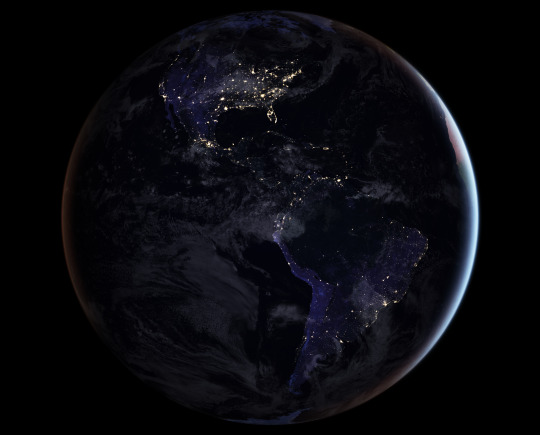
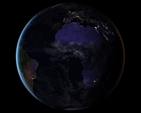
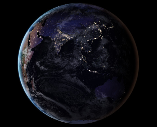
Earth at Night, Black Marble
4K notes
·
View notes
Text
Desaparece el último glaciar en Venezuela
El glaciar Humboldt de Venezuela ha llegado a su fin, esta pérdida es el último golpe a los glaciares tropicales de nuestro planeta, que se han ido reduciendo y desapareciendo a medida que las temperaturas han aumentado, informó @nasaearth.
Agencias/Ciudad de México.- Venezuela ha dejado de ser un país con glaciares tras la desaparición del glaciar Humboldt. Esta pérdida es el último golpe a los glaciares tropicales, que han ido desapareciendo a medida que las temperaturas han aumentado. Una comparación de imágenes muestra el cambio en la extensión del hielo del glaciar entre 2015 y 2024. Las imágenes se adquirieron con el OLI…
0 notes
Text
Intense blazes, including the #LineFire in Southern California, created “fire clouds” that matured into thunderstorms. #Landsat 8 captured a #pyrocumulus rising from the fire on Sept. 9. Active fires are marked in red." @NASAEarth
0 notes
Photo
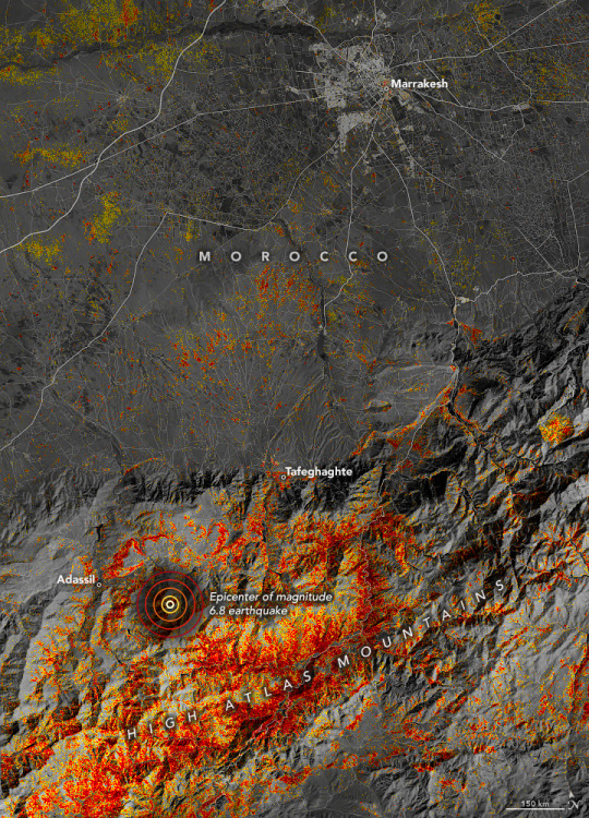
A magnitude 6.8 earthquake struck western Morocco on September 8, 2023, causing widespread damage.
This damage proxy map shows the estimated location and severity of the damage (severe shown in dark red).
by NASAEarth
93 notes
·
View notes
Text
https://x.com/nasa/status/1754505306850066908?s=12&t=bVZFAh1Oc_CqjoqGsnmNnA
Tune in as teams from @NASAKennedy discuss the upcoming launch of PACE, our @NASAEarth-observing spacecraft that will study the ocean and clouds, set to launch Feb. 6 at 1:33am ET (0633 UTC).
0 notes
Text

i’ve seen snow on mountains
@NASAEarth
First snow! ❄️
A cold front in mid-October 2023 delivered the first significant snowfall of the season to the Rocky Mountains. Snow was still visible on the mountains on Oct. 15, 2023, when NASA’s Terra satellite acquired this image.
10.19.23 • 6:03pm • X
1 note
·
View note
Text
Stars, Sea, and Smoke from the ISS: Tournament Earth 2021
We started Tournament Earth with 32 photos taken by astronauts from the Interantional Space Station and now we are down to 8. All of the #1 seeds are gone. Two #8 seeds are dominating their groups. Who will win? Let's take a closer look at the competitors still in the game. Then remember to vote for your favorites. The champion will be announced on April 13, 2021.
youtube
Stars in Motion vs. Cleveland Volcano
This matchup pits smoke against stars, but both have interesting stories.
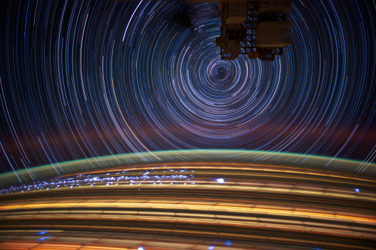
The International Space Station (ISS) is constantly in motion. For astronaut photographers on board, that motion has consequences. For one, it makes it challenging to take photos. The same motion makes it possible to shoot spectacular photos like the one above. The image is compiled from a series of photographs taken by astronaut Don Pettit while he was onboard the ISS in April 2012. This composite was made from more than 72 individual long-exposure photographs taken over several minutes as the ISS traveled over the Caribbean Sea, across South America, and over the South Atlantic Ocean.

Astronaut Jeff Williams was the first to witness activity at the Cleveland Volcano on May 3, 2006. The Cleveland Volcano is one of the most active in the Aleutian Islands, which extend west-southwest from the Alaska mainland. It is a stratovolcano composed of alternating layers of hardened lava, compacted volcanic ash, and volcanic rocks. The event proved to be short-lived; two hours later, the plume had completely detached from the volcano. The ash cloud height could have been as high as 6,000 meters (20,000 feet) above sea level.
Stargazing from the ISS vs. Cruising Past the Aurora Borealis
This is the most stellar matchup of the tournament, literally. Two beloved star pictures face off in what will be one of the most difficult choices of the tournament.
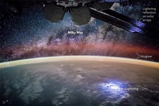
An astronaut took this broad, short-lens photograph of Earth’s night lights while looking out over the remote reaches of the central equatorial Pacific Ocean. The ISS was passing over the island nation of Kiribati at the time, about 2600 kilometers (1,600 miles) south of Hawaii. Scientists identified the pattern of stars in the photo as our Milky Way galaxy (looking toward its center). The dark patches are dense dust clouds in an inner spiral arm of our galaxy; such clouds can block our view of stars toward the center. The curvature of the Earth crosses the center of the image and is illuminated by a variety of airglow layers in orange, green, and red.
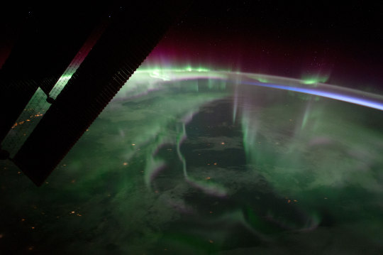
Commonly known as the northern lights, these colorful ribbons of light appear to dance in the sky over the planet’s high latitudes, attracting sky chasers and photographers. Astronaut Randy “Komrade” Bresnik shot this photograph on September 15, 2017, as the space station passed over Ontario, Canada. Curtains of green—the most familiar color of auroras—dominate the light show, with hints of purple and red.
Rolling Through the Appalachians vs. Castellanus Cloud Tower
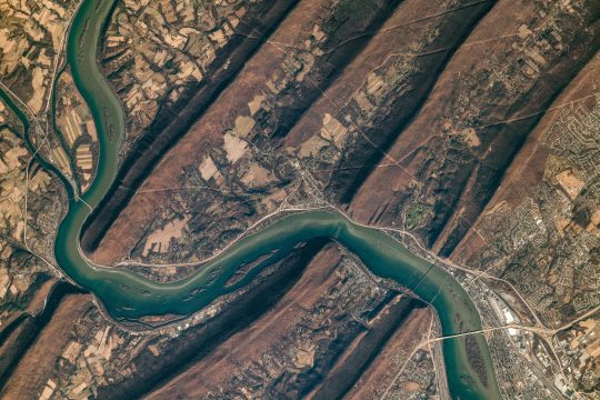
The Susquehanna River cuts through the folds of the Valley-and-Ridge province of the Appalachian Mountains in this photograph taken from the International Space Station by astronaut Christina Koch. The Valley-and-Ridge province is a section of the larger Appalachian Mountain Belt between the Appalachian Plateau and the Blue Ridge physiographic provinces. The northeast-southwest trending ridges are composed of Early Paleozoic sedimentary rocks. The valleys between them were made of softer rocks (limestone and shales) that were more susceptible to erosion; they are now occupied by farms.
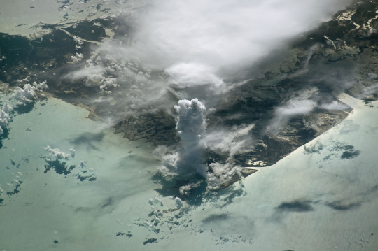
An astronaut aboard the International Space Station took this photograph of a massive vertical cloud formation—known to meteorologists as cumulus castellanus—above Andros Island. The cloud name castellanus comes from the similarity to the crenellated towers or turrets of medieval castles. These clouds develop due to strong vertical air movement typically associated with thunderstorms.
Lake Van, Turkey vs. Typhoon Maysak from the Space Station
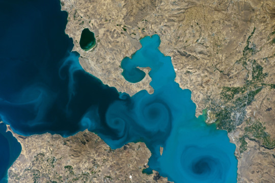
While orbiting on the International Space Station, astronaut Kate Rubins shot this photograph of part of Lake Van in Turkey, the largest soda or alkaline lake on Earth. Generally, soda lakes are distinguished by high concentrations of carbonate species. Lake Van is an endorheic lake—it has no outlet, so its water disappears by evaporation—with a pH of 10 and high salinity levels.
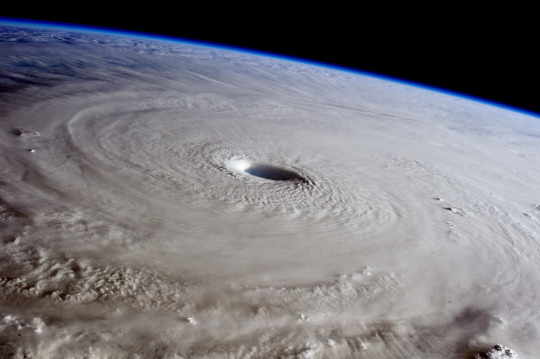
This photograph of super typhoon Maysak was taken by European Space Agency astronaut Samantha Cristoforetti as the International Space Station passed near the storm on March 31, 2015. The category 4 typhoon was headed for a possible landfall in the Philippines by the end of the week. It was unusual for the western Pacific to see such a strong storm so early in the year.
See all of the images and vote HERE. Follow @NASAEarth on social media for updates.
Make sure to follow us on Tumblr for your regular dose of space: http://nasa.tumblr.com
#Earth#Earth 2021#Earth Day#home planet#earth pictures#tournament earth#nasaearth#blue marble#space pictures#space station#Youtube
2K notes
·
View notes
Photo

1 note
·
View note
