#MapDesign
Explore tagged Tumblr posts
Visit Tumblr Blog
Explore Tumblr blogs with no restrictions, modern design and the best experience.
Last Seen Tumblr Blogs


Fun Fact
In 2020, Tumblr had 29.4 million users in the US.
Text
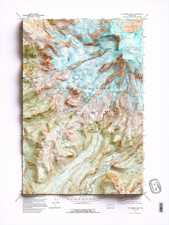
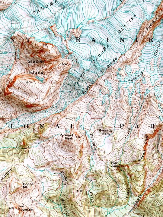
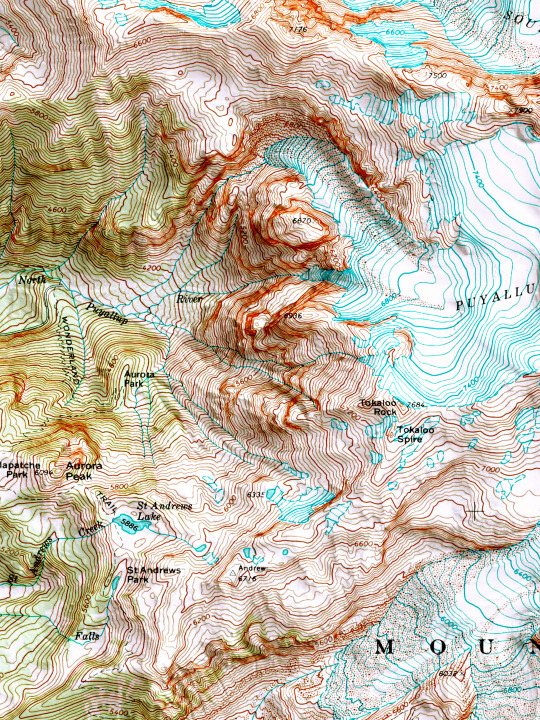
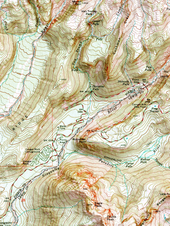
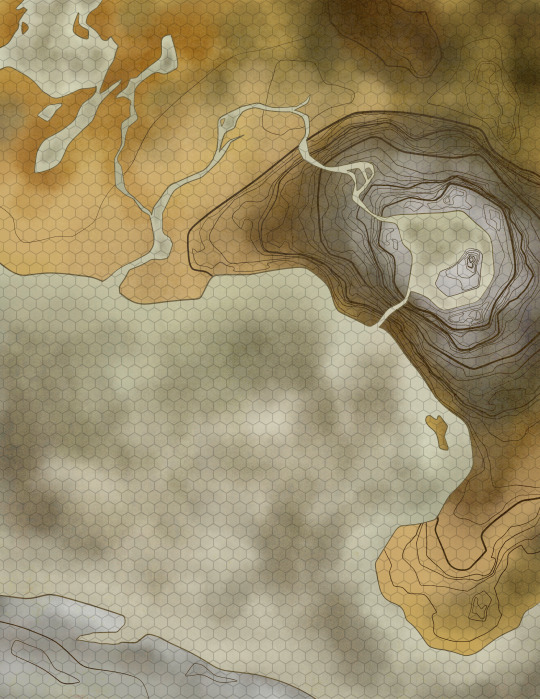
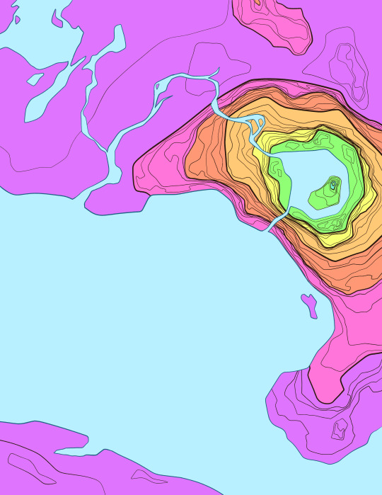
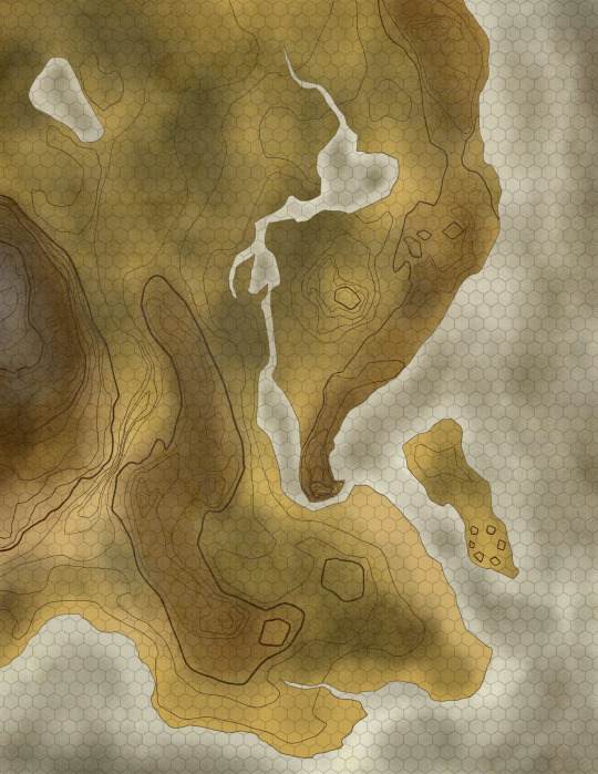
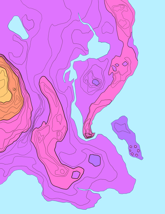
2D printed shaded relief map with 3D effect of a topographic map of Mount Rainier West, Washington (United States of America), from the Quadrangle series map and prepared and published by U.S. Geological Survey in 1971.
If you like our work, want to see our daily updates (or want to say hello to our studio), consider to follow our Instagram or Twitter account. Otherwise if are interested in our prints or have a custom request check our shop.
#mtrainer#mtrainernationalpark#mtrainiersummit#Washington#washingtontrails#mountaineering#mountainlife#mountain#topographic#topographicmap#wallart#wallartprint#mapdesign#naturegeography#wildgeography#usanaturetour#mtrainierdesign#mtrainierwatch#framedart#framed
70 notes
·
View notes
Text
Mapping mysteries ✨✨
4 notes
·
View notes
Text
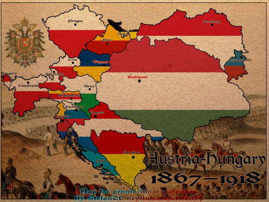
One of my earlier posters/maps features Austria-Hungary. It highlights its borders, the internal divisions into provinces, and their respective capital cities.
#AustriaHungary#HistoricalMaps#Cartography#MapLovers#HistoryBuff#Austria#Hungary#HabsburgEmpire#DualMonarchy#HistoryNerd#MapsOfEurope#VintageMaps#Geography#MapArt#HistoricalPoster#EuropeanHistory#OldBorders#HistoryEnthusiast#Provinces#CapitalCities#AustriaHungaryMap#HistoricBorders#EmpireMaps#HistoryCommunity#MapDesign#CulturalHistory#HistoricEurope#PoliticalDivisions#HistoryIllustration#MapPoster
4 notes
·
View notes
Text
I love to draw maps and work the topography of those! These three are part of a commission containing 11maps for one continent!
🎉Etsy ✨Patreon 💙Discord 👀Commissions
9 notes
·
View notes
Photo
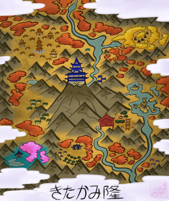
A map of Kitakami from prosperous times past, commission for an upcoming game I'll be playing in! 🍂🏯
#illustration#digitalart#map#mapillustration#kitakami#ancientkitakami#legendsarceus#ancientpokemon#mapdesign#commission#commissions#comms#commsopen#commissionme#dnd#dungeonsanddragons#dndoc#dndpc#dndnpc#artist#pokemon#pokemonoc#pokemonfanart
2 notes
·
View notes
Text
Gameplay video of Oldburries map for FiveM. Access here: https://fv-mods.tebex.io/package/6546026 Story Mode version is unencrypted and available here: https://ko-fi.com/s/446be2f75b
youtube
#GTA5Modding#FiveMMaps#RuralMapMod#CustomGTA5#ModdedMaps#OpenWorldMods#GTA5Mods#VirtualLandscapes#MapDesign#GamingCommunity#GamingLife#MapMods#GTA5ModdedMaps#GTA5ModdingCommunity#LandscapeModding#VirtualWorlds#GTA5Environment#ModdersUnite#ModdingLife#CreativeMods#GTA5Custom#Youtube
0 notes
Text
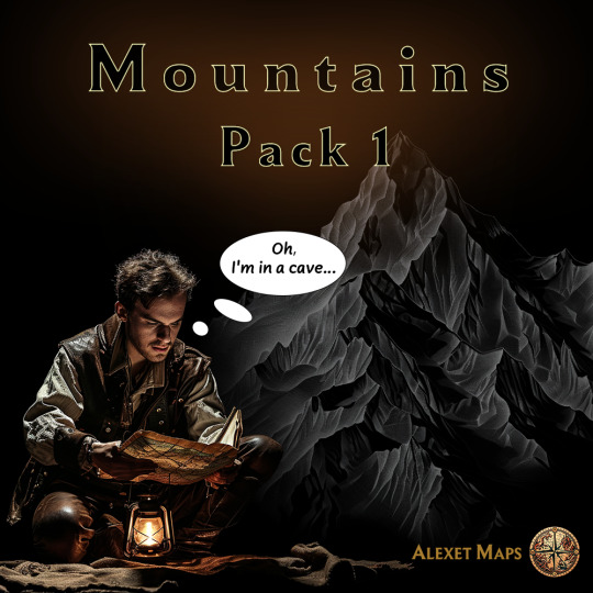
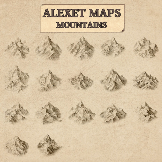

Embark on an epic journey of map-making with “Alexet’s Mountain Pack 1” for Wonderdraft! This thoughtfully curated collection boasts 17 magnificent mountain assets, each painstakingly crafted to infuse your maps with depth and authenticity.
Key Features:
1. 17 meticulously designed mountain assets await your creative touch.
2. Each mountain is presented in a resolution of 1000×1000 pixels, enabling you to craft maps in breathtaking 4K and 8K resolutions.
3. Seamless integration with Wonderdraft ensures effortless incorporation into your map-making projects.
4. Elevate your landscapes with dramatic mountain ranges, towering peaks, and rugged terrains, captivating your audience and immersing them in your worlds.
Whether you’re charting the course of a fantastical realm, envisioning a post-apocalyptic wilderness, or creating an epic adventure world, “Alexet’s Mountain Pack 1” is the ultimate enhancement for your Wonderdraft toolkit. Elevate your maps to unprecedented heights and ignite the imagination of your players and readers. Don’t wait – download this extraordinary pack today and let your creative spirit take flight!
Please note that these assets are available for both personal and commercial use in your Wonderdraft maps. Give your maps the majestic backdrop they deserve with “Alexet’s Mountain Pack 1”.
You can purchase it here:
https://cartographyassets.com/assets/43929/mountain-pack-for-wonderdraft-by-alexet/
#FantasyMaps#RPGMapping#WorldBuilding#FantasyWorlds#TerrainDesign#MapArt#Geography#MapDesign#Landscaping#BiomeArt#FantasyLore#GameMasterResources#DigitalCartography#DnDMaps#DnDWorlds#DungeonDesign#FantasyRPG#RolePlaying#WonderdraftAssets#WonderdraftMaps#FantasyCartography#RPGCampaigns#HomebrewWorlds#FantasySetting#MapEditor#FantasyTerrain#digital art#cartography#assets#maps
1 note
·
View note
Photo

Illustrated map of California on Behance Calling all art enthusiasts and adventure seekers. Dive into the delightful Illustrated map of California on Behance for a playful journey like no other.
0 notes
Text
Culver City Illustrated Map Joya Rose Illustration and Hand Lettering
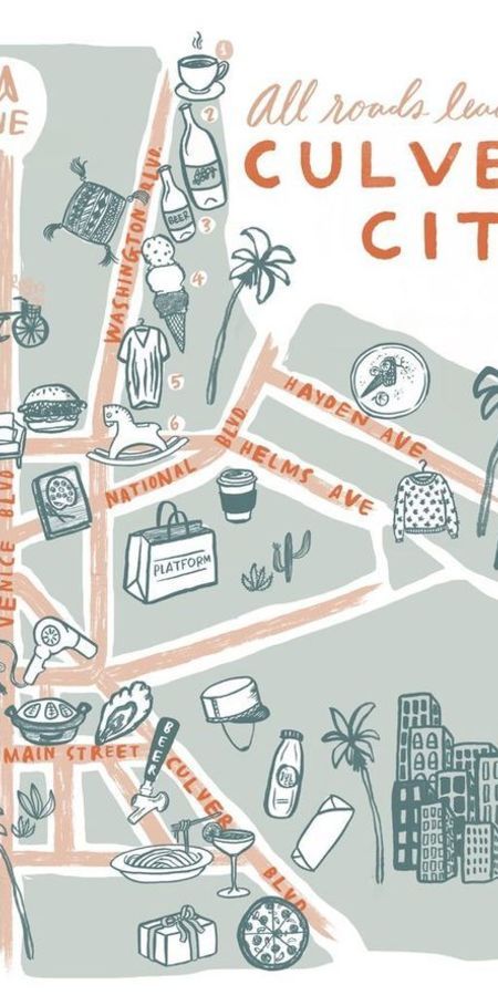
Discover the vibrant charm of Culver City with this beautifully illustrated map by Joya Rose. Explore the city's landmarks and hidden gems through detailed hand lettering and captivating illustrations.
0 notes
Text
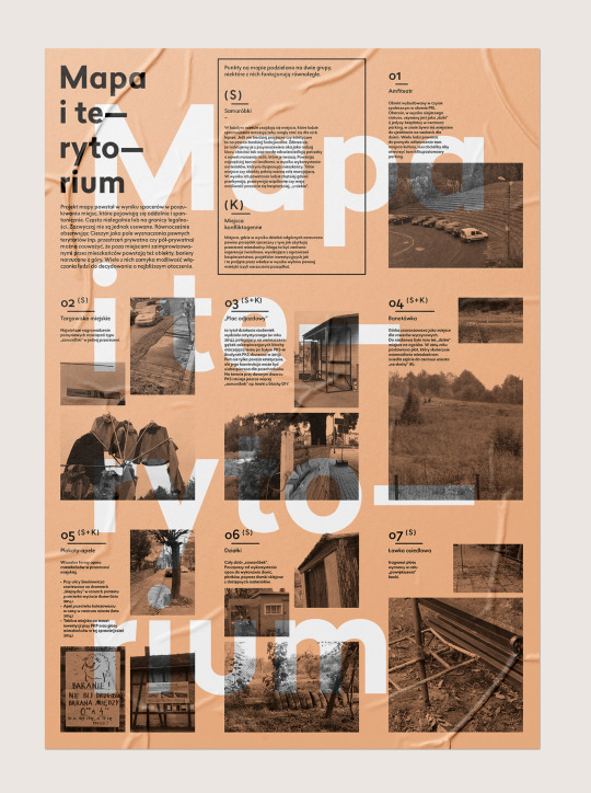
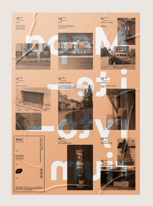
Mapa i terytorium
Projekt mapy dla Świetlicy Krytyki Politycznej w Cieszynie.
"Projekt mapy powstał w wyniku spacerów w poszukiwaniu miejsc, które pojawiają się oddolnie i spontanicznie. Często nielegalnie lub na granicy legalności. Zazwyczaj nie są jednak usuwane. Równocześnie obserwując Cieszyn jako pole wyznaczania pewnych terytoriów (np. Przestrzeń prywatna czy pół-prywatna) można zauważyć, że poza miejscami zaimprowizowanymi przez mieszkańców powstają też obiekty, bariery narzucane z góry. Wiele z nich zamyka możliwość włączania ludzi do decydowania o najbliższym otoczeniu."
Treść: Anna Cieplak Projekt graficzny: Hubert Tereszkiewicz
0 notes
Text
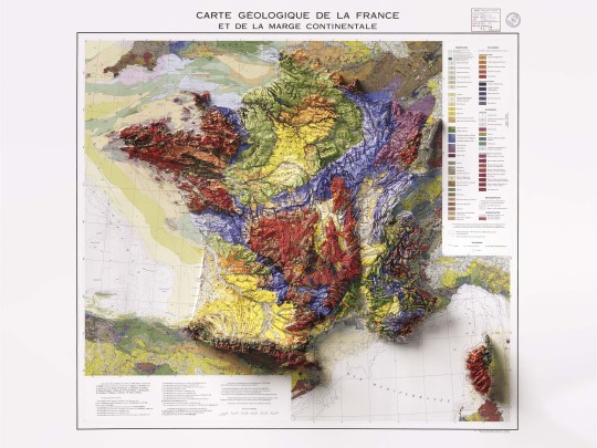
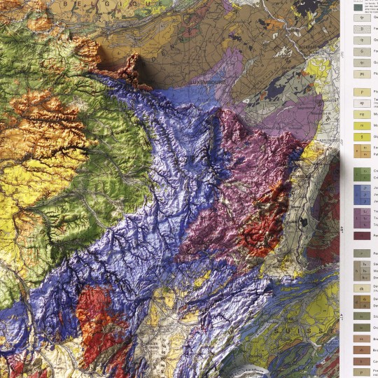
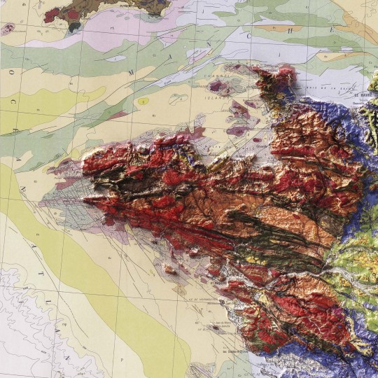
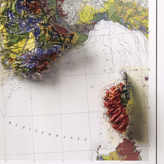
Shaded relief geological map of continental France, 1980.
🗺️ 𝗠𝗔𝗣 𝗜𝗡𝗙𝗢
Carte geologique et marge continentale, 1980. Département des Arts graphiques du B.R.G.M. Source: ESDAC.
If you like our work, want to see our daily updates (or want to say hello to our studio), consider to follow our Instagram or Twitter account. Otherwise if are interested in our prints or have a custom request check our shop.
#GeologicalMap#FranceMap#ShadedRelief#CartographyArt#MapDesign#GeologyMap#VintageMaps#BRGM#MapLovers#ReliefMap#MapCollection#GeologyArt#TopoMap#EarthScience#CartographyCommunity
5 notes
·
View notes
Photo
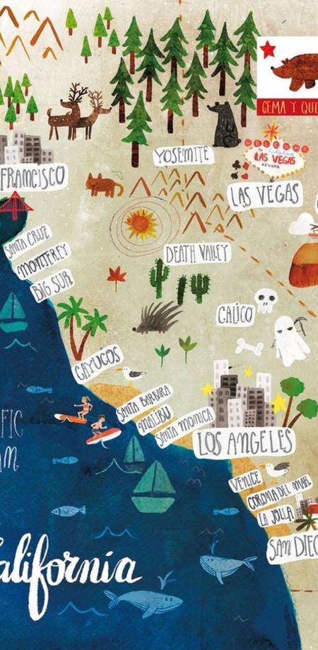
Illustrated map of California on Behance Get lost in the artistic enchantment of California through this charming illustrated map on Behance.
0 notes
Text
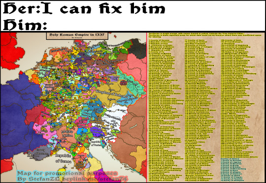
Can she, tho? 🤔 A meme created from my map 'The Holy Roman Empire in 1337' 🗺️—for those who don't find maps interesting on their own 😅
#HolyRomanEmpire#HistoricalMeme#MapMeme#1337#HistoryHumor#MapArt#HistoryGeeks#MapLovers#MedievalHistory#Cartography#HRE#CanSheTho#HistoryInMaps#MapCollectors#DigitalArt#MapDesign
2 notes
·
View notes
Text
Visit IconAdda for free map icons and illustrations
BY ICONADDA ,

When you are creating maps or adding artwork to your projects, it is not easy to find good images, graphics, and stickers. We at IconAdda make this process easy by providing free logos and graphics to meet all your needs. Our free content can help you improve your career as an entertainer, designer, or graphic designer.
Why did you choose IconAdda for photo and map icons?
A vast majority of free icons: From place pins and landmarks to navigation and weather icons, our large collection has everything you need for anything related to maps, and each icon is a masterly crafted piece to ensure you get quality jobs.
Better Images: IconAdda provides free images to make your map come alive. Our images are perfect for beautiful and attention-grabbing landscapes, either natural or urban.
Customizable Stickers: Use our free stickers to give a bright, unique touch. Our stickers are available in several styles to suit any theme or interest, from bright, funny, to downright simple design.
Advantages of downloading free icons and images from IconAdda Free for all: Every single one of our products is free to download and use, meaning anyone can download them. Easy download: The friendly interface makes it easy to search, select and download the logo, image or sticker you need. Compatible with most platforms: Our products work seamlessly with all the popular design software, such as Canva, Figma, and Adobe Illustrator.
Our library is constantly updated with new material to ensure that you have the most recent material at your fingertips.

How to use the free map assets from IconAdda
Browse the library: See our free logos, images, and stickers by visiting IconAdda.
Buy your favorite one here: Choose the resources that would be a great fit for your project and drag and drop them on high-resolution.
Add it to your projects: use it for your website, maps, presentations, other creative projects.
Update your map with IconAdda’s free resources
We hope the free logos and inspirational images will improve and inspire designers around the world at IconAdda. Use any of our free logos and images for travel guides, educational maps or personal projects. Get free map icons , images and stickers now at IconAdda and customize your layout by searching here.
#MapDesigns#MapAssets#CreativeMaps#NavigationGraphics#MapIcons#CartographyArt#MapStickers#TravelIllustrations#LocationGraphics#WorldMapArt#PathwayDesigns#DestinationGraphics#AdventureAssets#MappingCreativity#ExploreDesigns
0 notes
Photo
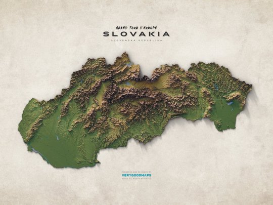
European countries, part twentyone: Slovakia looks bumpy and wonderful. #mapping #cartography #mapdesign #Slovakia
by @verygoodmaps
120 notes
·
View notes