#Chelan County
Explore tagged Tumblr posts
Visit Tumblr Blog
Explore Tumblr blogs with no restrictions, modern design and the best experience.
Last Seen Tumblr Blogs


Fun Fact
Tumblr was created by web developers David Karp and Marco Arment.
Text

Edge of Alpine Lakes Wilderness, 2019.
Illustration of a frustration, for there was no time to leave the road and hike into the wilderness.
#landscape#mountains#forest#chelan county#washington state#2019#photographers on tumblr#pnw#pacific northwest
112 notes
·
View notes
Text


Wells Dam Rest Area And Information Center, WA (No. 5)
The Columbia begins its 1,243 mi (2,000 km) journey in the southern Rocky Mountain Trench in British Columbia (BC). Columbia Lake – 2,690 ft (820 m) above sea level – and the adjoining Columbia Wetlands form the river's headwaters. The trench is a broad, deep, and long glacial valley between the Canadian Rockies and the Columbia Mountains in BC. For its first 200 mi (320 km), the Columbia flows northwest along the trench through Windermere Lake and the town of Invermere, a region known in BC as the Columbia Valley, then northwest to Golden and into Kinbasket Lake. Rounding the northern end of the Selkirk Mountains, the river turns sharply south through a region known as the Big Bend Country, passing through Revelstoke Lake and the Arrow Lakes. Revelstoke, the Big Bend, and the Columbia Valley combined are referred to in BC parlance as the Columbia Country. Below the Arrow Lakes, the Columbia passes the cities of Castlegar, located at the Columbia's confluence with the Kootenay River, and Trail, two major population centers of the West Kootenay region. The Pend Oreille River joins the Columbia about 2 miles (3 km) north of the United States–Canada border.
Source: Wikipedia
#Highway 97#Wells Dam#Columbia River#Wells Salmon Hatchery#Chelan County#travel#original photography#vacation#tourist attraction#landmark#architecture#landscape#countryside#technology#engineering#Pacific Northwest#Washington#USA#summer 2023#Wells Dam Rest Area And Information Center#nature#flora#rocks#hill
10 notes
·
View notes
Text


Autumn in the North Cascades
#north cascades#chelan county#washington#stiletto peak#larches#trees#plants#chipmunks#squirrels#animals
3 notes
·
View notes
Text

Chelan County Fire District 3, Leavenworth, WA
#larry shapiro#larryshapiroblog.com#shapirophotography.net#larryshapiro#larryshapiro.tumblr.com#fire truck#firetruck#fire engine#Freightliner#KME#tender#tanker#chelan county#Leavenworth WA#ChelanCountyFD3
8 notes
·
View notes
Text

North Cascades National Park, Washington, United States: North Cascades National Park is an American national park in the state of Washington. At more than 500,000 acres, it is the largest of the three National Park Service units that comprise the North Cascades National Park Complex. North Cascades National Park consists of a northern and southern section, bisected by the Skagit River that flows through the reservoirs of Ross Lake National Recreation Area. Lake Chelan National Recreation Area lies on the southern border of the south unit of the park. Wikipedia
73 notes
·
View notes
Text
HVL is an icon 💜

nah imagine your last game of the season and this is how you go out 😭
#HVL makes me think of a sickly street urchin who left home to do child labor at the Mulkey factory#I genuinely love HVL! Queen of Chelan County
24 notes
·
View notes
Text
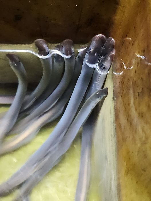
Pacific Lamprey Conservation
After hiding under the substrate at a fish research center for nearly 7 years as larvae, Pacific lamprey EMERGED as juveniles with eyes and a suction disk mouth! These fish, which are of Tribal and ecological importance, are now ready for their journey out to sea! The Abernathy Fish Technology Center in Washington worked in collaboration with the Yakama Nation, the Confederated Tribes of the Umatilla Indian Reservation and the Chelan County Public Utility District to conduct this research to further understand and conserve Pacific lamprey. This is a rare accomplishment to have Pacific lamprey reared and transformed in a captive setting.
USFWS photo: Amanda Sheehy
via: USFWS Columbia Pacific Northwest
#lamprey#ichthyology#fish#agnatha#nature#conservation#ocean#rivers#aquatic#PNW#north america#science#environment
662 notes
·
View notes
Photo

Weather: Pacific Northwest
Report generated at 2024-12-25 16:00:10.377378-08:00 using satellite imagery and alert data provided by the National Weather Service.
Winter Storm Warning
WA:
Central Chelan County
Lower Slopes of the Eastern Washington Cascades Crest
Okanogan Highlands
Okanogan Valley
Olympics
Upper Slopes of the Eastern Washington Cascades Crest
Waterville Plateau
Wenatchee Area
West Slopes North Cascades and Passes
West Slopes North Central Cascades and Passes
West Slopes South Central Cascades and Passes
Western Chelan County
Western Okanogan County
ID:
Bear River Range
Big Hole Mountains
Big Lost Highlands/Copper Basin
Blackfoot Mountains
Caribou Range
Centennial Mountains/Island Park
Franklin/Eastern Oneida Region
Marsh and Arbon Highlands
Raft River Region
Sawtooth/Stanley Basin
Southern Hills/Albion Mountains
Sun Valley Region
Teton Valley
Wood River Foothills
Winter Weather Advisory
WA:
Cascades of Lane County
Cascades of Marion and Linn Counties
North Oregon Cascades
Northeast Mountains
Northern Blue Mountains of Oregon
Northwest Blue Mountains
South Washington Cascades
Upper Columbia Basin
OR:
Baker County
Cascades of Lane County
Cascades of Marion and Linn Counties
East Slopes of the Oregon Cascades
North Central and Southeast Siskiyou County
North Oregon Cascades
Northern Blue Mountains of Oregon
Northwest Blue Mountains
Siskiyou Mountains and Southern Oregon Cascades
South Central Oregon Cascades
South Central Siskiyou County
South Washington Cascades
Upper Weiser River
Western Siskiyou County
ID:
Arco/Mud Lake Desert
Baker County
Bear Lake Valley
Beaverhead/Lemhi Highlands
Boise Mountains
Camas Prairie
Central Panhandle Mountains
Eastern Magic Valley
Frank Church Wilderness
Lost River Range
Lower Snake River Plain
Northern Clearwater Mountains
Northern Panhandle
Shoshone/Lava Beds
Southern Clearwater Mountains
Upper Snake River Plain
Upper Treasure Valley
Upper Weiser River
West Central Mountains
Western Magic Valley
CA:
Greater Lake Tahoe Area
Lassen-Eastern Plumas-Eastern Sierra Counties
Mono
North Central and Southeast Siskiyou County
Northern Trinity
Siskiyou Mountains and Southern Oregon Cascades
South Central Oregon Cascades
South Central Siskiyou County
West Slope Northern Sierra Nevada
Western Plumas County/Lassen Park
Western Siskiyou County
NV:
Greater Lake Tahoe Area
Northern Elko County
Ruby Mountains and East Humboldt Range
South Central Elko County
Southwest Elko County
Coastal Flood Warning
WA:
Central Coast
Coastal Flood Advisory
WA:
Eastern Strait of Juan de Fuca
North Coast
South Washington Coast
Western Strait of Juan De Fuca
High Surf Advisory
WA:
Central Coast
North Coast
South Washington Coast
OR:
Central Coast of Oregon
Clatsop County Coast
Tillamook County Coast
CA:
Catalina and Santa Barbara Islands
Coastal Del Norte
Coastal North Bay Including Point Reyes National Seashore
Los Angeles County Beaches
Malibu Coast
Mendocino Coast
Northern Humboldt Coast
Northern Monterey Bay
San Diego County Coastal Areas
San Francisco
San Francisco Peninsula Coast
San Luis Obispo County Beaches
Santa Barbara County Central Coast Beaches
Santa Barbara County Southeastern Coast
Santa Barbara County Southwestern Coast
Southern Monterey Bay and Big Sur Coast
Southwestern Humboldt
Ventura County Beaches
High Wind Warning
WA:
Admiralty Inlet Area
Central Coast
Clatsop County Coast
North Coast
San Juan County
South Washington Coast
Western Skagit County
Western Whatcom County
Willapa Hills
OR:
Central Coast of Oregon
Central and Eastern Lake County
Clatsop County Coast
Curry County Coast
Modoc County
Northern and Eastern Klamath County and Western Lake County
South Central Oregon Coast
South Washington Coast
Tillamook County Coast
ID:
Orofino/Grangeville Region
CA:
Central and Eastern Lake County
Coastal Del Norte
Modoc County
Northern and Eastern Klamath County and Western Lake County
Wind Advisory
WA:
Admiralty Inlet Area
Bellevue and Vicinity
Bremerton and Vicinity
Central Panhandle Mountains
Coeur d'Alene Area
East Puget Sound Lowlands
Everett and Vicinity
Foothills of the Blue Mountains of Washington
Foothills of the Northern Blue Mountains of Oregon
Hood Canal Area
Idaho Palouse
Lower Chehalis Valley Area
Lower Garfield and Asotin Counties
San Juan County
Seattle and Vicinity
Southwest Interior
Spokane Area
Tacoma Area
Upper Columbia Basin
Washington Palouse
Western Skagit County
Western Whatcom County
OR:
Central Oregon
Eastern Curry County and Josephine County
Foothills of the Blue Mountains of Washington
Foothills of the Northern Blue Mountains of Oregon
Foothills of the Southern Blue Mountains of Oregon
Grande Ronde Valley
Jackson County
North Central Oregon
ID:
Central Panhandle Mountains
Coeur d'Alene Area
Idaho Palouse
Lewis and Southern Nez Perce Counties
Spokane Area
Washington Palouse
CA:
Central Siskiyou County
Del Norte Interior
Greater Reno-Carson City-Minden Area
Interstate 5 Corridor
Northern Humboldt Coast
Northern Humboldt Interior
Northern Ventura County Mountains
Northern Washoe County
Santa Barbara County Interior Mountains
Santa Barbara County Southwestern Coast
Santa Ynez Mountains Eastern Range
Santa Ynez Mountains Western Range
Southern Humboldt Interior
Southern Ventura County Mountains
Southwestern Humboldt
Surprise Valley California
NV:
Greater Reno-Carson City-Minden Area
Northern Washoe County
Surprise Valley California
Hydrologic Outlook
WA:
Grays Harbor
Flood Watch
WA:
Clallam
Flood Warning
WA:
Mason
High Surf Warning
OR:
Curry County Coast
South Central Oregon Coast
Lake Wind Advisory
NV:
Western Nevada Basin and Range including Pyramid Lake
4 notes
·
View notes
Text
U.S. daily high temperature records tied/broken 1/27/2025
Anchorage, Alaska: 48 (previous record 43 2023) Unincorporated Copper River Census Area, Alaska: 41 (previous record 37 2001) Unincorporated Fairbanks North Star Borough, Alaska: 43 (previous record 37 2001) Unincorporated Fairbanks North Star Borough, Alaska: 41 (previous record 37 1994) Unincorporated Fairbanks North Star Borough, Alaska: 38 (also 38 2001) Unincorporated Fairbanks North Star Borough, Alaska: 39 (also 39 1945) Nenana, Alaska: 43 (previous record 41 2014) North Pole, Alaska: 38 (previous record 34 2016) Unincorporated Southeast Fairbanks Census Area, Alaska: 41 (previous record 35 2014) Unincorporated Southeast Fairbanks Census Area, Alaska: 45 (previous record 26 1991) Unincorporated Southeast Fairbanks Census Area, Alaska: 42 (previous record 38 2016) Unincorporated Southeast Fairbanks Census Area, Alaska: 42 (previous record 37 1994) Unincorporated Southeast Fairbanks Census Area, Alaska: 36 (previous record 26 1968) Unincorporated Yukon-Koyukuk Census Area, Alaska: 20 (previous record 19 2016) San Rafael, California: 67 (also 67 2015) Yigo, Guam: 86 (also 86 1989) Juana Díaz, Puerto Rico: 91 (also 91 2015) Limaní, Puerto Rico: 84 (previous record 83 2019) Sabana Yeguas, Puerto Rico: 93 (previous record 90 2003) Unincorporated Box Elder County, Utah: 48 (previous record 47 2020) Corral Pass summit, Washington: 54 (previous record 53 2022) Lake Chelan National Recreation Area, Washington: 51 (previous record 47 1995)
4 notes
·
View notes


Text
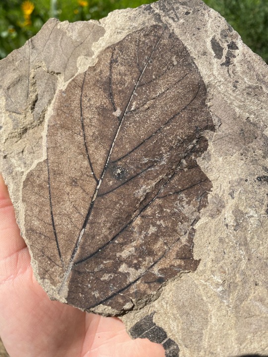
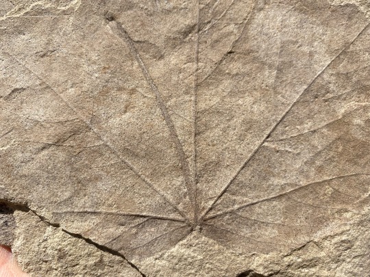
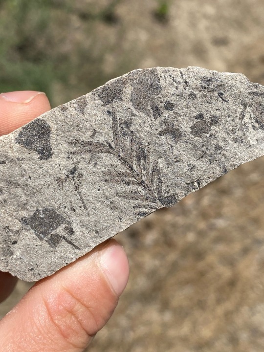
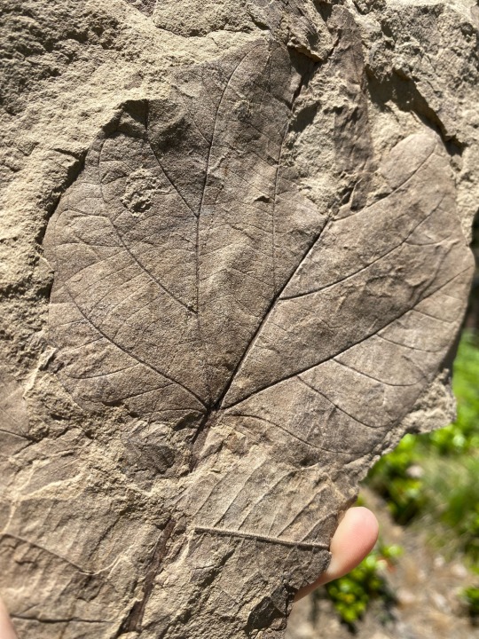
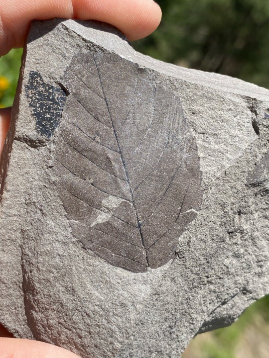
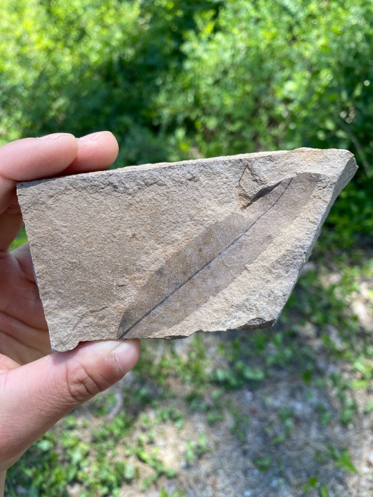
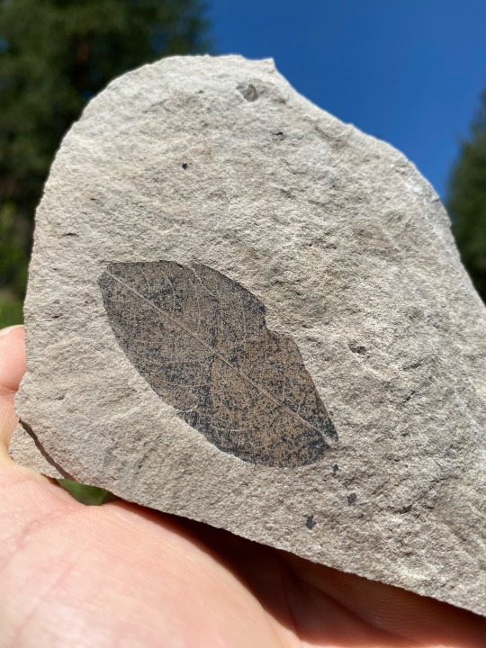
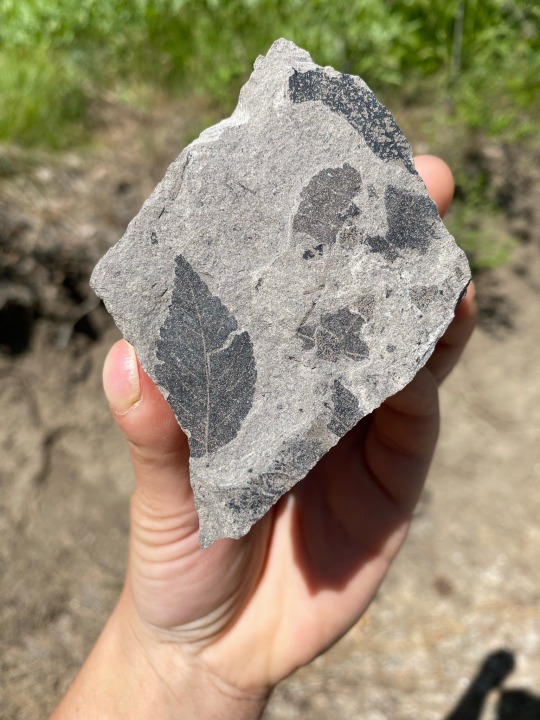
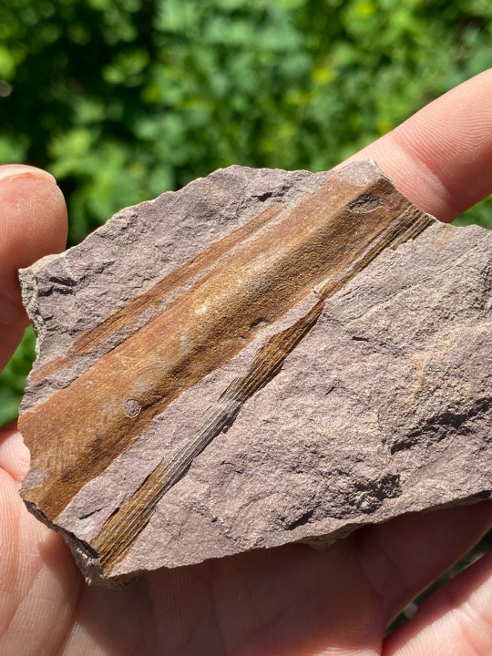
Amazingly preserved leaf fossils from Chelan County, Washington, USA!😍🍂🍃
Available on my Etsy🤗💎: https://www.etsy.com/shop/ConfluenceMinerals
#crystals#hiking#minerals#mining#quartz#crystal gems#fossils#mountains#natural#nature#plants#plantlife#witchcore#botanical#botany#dinosaur#earthbound#mother earth#gaia
14 notes
·
View notes
Text

End of a road leading to the Alpine Lakes Wilderness, Chelan County, 2019.
Sadly on our 2019 trip this was as close to the Enchantments as I could get as we had to be in the BC Gulf Islands two days later.
#landscape#mountains#cascade mountains#chelan county#washington state#photographers on tumblr#pnw#pacific northwest
22 notes
·
View notes
Text


Wells Dam Rest Area And Information Center, WA (No. 6)
The Columbia enters eastern Washington flowing south and turning to the west at the Spokane River confluence. It marks the southern and eastern borders of the Colville Indian Reservation and the western border of the Spokane Indian Reservation. The river turns south after the Okanogan River confluence, then southeasterly near the confluence with the Wenatchee River in central Washington. This C-shaped segment of the river is also known as the "Big Bend". During the Missoula Floods 10–15,000 years ago, much of the floodwater took a more direct route south, forming the ancient river bed known as the Grand Coulee. After the floods, the river found its present course, and the Grand Coulee was left dry. The construction of the Grand Coulee Dam in the mid-20th century impounded the river, forming Lake Roosevelt, from which water was pumped into the dry coulee, forming the reservoir of Banks Lake.
Source: Wikipedia
#Highway 97#Wells Dam#Columbia River#Wells Salmon Hatchery#Chelan County#travel#original photography#vacation#tourist attraction#landmark#architecture#landscape#countryside#technology#engineering#Pacific Northwest#Washington#USA#summer 2023#Wells Dam Rest Area And Information Center#nature#flora#rocks#hill#turbine
8 notes
·
View notes
Photo

An unnamed Sears typewriter, which appears to be a rebranded Brother machine (the single arrow for backspace and double arrow for margin release give it away), seen in Chelan County, WA in February.
5 notes
·
View notes
Text
Industry veteran Joe Cohen purchases River Barrel Distribution.
https://bit.ly/3WxFnhK Press Release Seattle, WA … River Barrel Distributing (RBD), Western Washington’s premier craft beverage distributor, proudly announces a new chapter as industry veteran Joe Cohen steps into ownership. Renowned for a steadfast commitment to quality, customer service, and local beverage support, River Barrel Distributing is energized to move forward with the Cohen family now leading the charge. Founded four years ago by Buoy Beer, RBD has flourished from a startup into a thriving company, now representing a diverse range of respected beverage brands. With this growth comes an evolution in the company’s needs and resources. To sustain RBD's expansion and continue its trajectory, Buoy made the strategic decision to transition ownership and operations to RBD’s own Sales Manager, Joe Cohen. Cohen brings 12 years of experience in the craft beverage industry, having led RBD’s sales division since its inception and previously serving in sales roles with Breakside Brewing and other regional brands. His passion for craft beverages and commitment to quality position him to guide River Barrel into a promising future. Since stepping into leadership, Cohen and the River Barrel team have partnered with four exciting new brands. Hailing from Portland, OR, they have been joined by Little Beast Brewing, Hetty Alice Beers, and Living Haus Beer Co, along with Norway’s iconic Aass Brewing (pronounced “ouse”). “I’m deeply honored to lead River Barrel and incredibly grateful to Buoy for their foresight in founding RBD,” Cohen shared. “With the support of our suppliers and dedicated team, I’m excited to build upon the values that make RBD an industry leader and to further serve our customers and the vibrant beverage enthusiasts across Western Washington for years to come.” Under Cohen’s leadership, River Barrel Distributing is committed to strengthening relationships with local suppliers, enhancing distribution services, and maintaining its mission of delivering a top-tier portfolio of unique, high-quality craft beverages to Western Washington. About River Barrel Distributing: River Barrel Distributing is a premier craft beverage distributor serving Western Washington, specializing in a carefully curated selection of top-quality craft beer, spirits, wine, and cider for bars, restaurants, and retailers across the region. Founded with a dedication to quality and customer service, RBD takes pride in supporting the artistry of craft beverages and connecting passionate producers with beverage enthusiasts. RBD’s service area currently spans Washington counties, including King, Pierce, Thurston, Lewis, Snohomish, Kitsap, Jefferson, Clallam, Kittitas and Chelan. from Northwest Beer Guide - News - The Northwest Beer Guide https://bit.ly/3PUAvPW
1 note
·
View note
Text
Exploring the Green Frontier: Chelan County's Growing Cannabis Culture
In the heart of Washington State lies Chelan County, a region known for its picturesque landscapes and thriving agricultural scene. However, in recent years, another industry has been steadily gaining ground – cannabis. With the legalization of recreational marijuana in Washington in 2012, Chelan County has seen the emergence of pot shops catering to the growing demand for cannabis products.
The Rise of Chelan Pot Shops
Driven by changing attitudes towards cannabis and the potential for economic growth, Chelan pot shop have become a significant presence in the county's retail landscape. These dispensaries offer a variety of cannabis products, including flowers, edibles, concentrates, and accessories, attracting both locals and tourists alike.
Meeting Consumer Needs
One of the key factors contributing to the success of Chelan pot shops is their ability to meet the diverse needs of consumers. Whether customers are seeking relief for medical conditions or simply looking to relax and unwind, these dispensaries offer a range of products tailored to different preferences and purposes.
Supporting Local Economy
Beyond catering to consumer demand, Chelan County pot dispensaries play a crucial role in supporting the local economy. By providing employment opportunities and generating tax revenue, these businesses contribute to the financial well-being of the community, helping to fund essential services and infrastructure projects.
Embracing Responsible Consumption
Despite the growing popularity of cannabis, Chelan County pot shops are committed to promoting responsible consumption practices. Through education and outreach initiatives, these dispensaries aim to empower consumers with the knowledge they need to make informed decisions about their cannabis use, emphasizing the importance of moderation and mindfulness.
Navigating Regulatory Challenges
While the legalization of recreational marijuana has created opportunities for Chelan pot shops, it has also presented regulatory challenges. From navigating complex licensing requirements to adhering to strict compliance standards, dispensary owners must navigate a highly regulated environment to ensure their operations remain above board.
Looking Ahead: The Future of Cannabis in Chelan County
As the cannabis industry continues to evolve, Chelan County pot dispensaries are poised to play an increasingly prominent role in the region's economy and culture. With continued innovation and investment, these businesses have the potential to drive further growth and development, cementing their place as valuable contributors to the community.
Conclusion:
Chelan County pot dispensaries represent a growing sector of the local economy, offering consumers access to a wide range of cannabis products while supporting the community through job creation and tax revenue. As attitudes towards cannabis continue to evolve, these pot shops will play an integral role in shaping the future of Chelan County. For those interested in exploring the diverse world of cannabis products, visit GreenLifeCannabis.com to discover a wide selection of high-quality offerings.
0 notes