#wonderful maps
Text
Worldbuilding: Conquering the Map
Okay, someone needs to do a Grand Epic Fantasy where the Evil Overlord... has some trouble conquering exactly where he intends to, because he doesn’t have a good enough map.
No, really. This has happened. Probably multiple times through history. “Ramses invading Syria, that was an accident,” isn’t just a bit of dialogue from The Mummy.
If you read ancient history, there were claims of him “accidentally” invading that bit of territory. Right, right, and he accidentally had scouts sent ahead to bury water supplies in the desert so his guys could force-march through, could’ve happened to anybody....
But let’s take an example closer to modern time, with a bit more of an accessible historical record. Say, the Imjin War. AKA Toyotomi Hideyoshi deciding to give all of Korea six long years of Very Bad Days. Salt in the wound, there, was that he mostly wanted Korea as a stepping stone to invading and conquering all of Asia, and Europe on top of that. Well, that and seizing their ginseng and falcons. No, really, he had teams of samurai out capturing goshawks and other birds of prey everywhere the Japanese forces went. Takagari (hunting with hawks, or as we call it falconry) being important for samurai showing off to other samurai. And especially important given Hideyoshi had started out as a common soldier. You can guess that even after he became shogun, the other samurai never let him forget he wasn’t noble blood....
Back to the maps. And confusion thereof. Apparently Hideyoshi had been planning the invasion for well over a decade, but he had Problems. At least one of them being that he originally intended to invade Korea and China by way of Ezo (modern name, Hokkaido). Under the impression there was a land bridge that way leading to Sakhalin Island and Manchuria.
Reality? Noooot so much.
What’s kind of amusing is that he seems to have gotten this idea from a European map of the area. Instead of, you know, asking the sailors.
(OTOH he may have been studying his history, and the Ainu did invade the Yuan Empire in the 1300s. Thing was, they were living on the coast of Manchuria at the time!)
In the 1590s, though, Hideyoshi did visit Ezo, and spoke to the domain lords... who apparently very carefully set him straight on where the island did not lead to. The elder lord, Kakizaki Suehiro (they only took the family name Matsumae later, when they switched allegiance to Tokugawa Ieyasu) even sent sea otter furs from the Ainu to help keep invading soldiers warm.
Who knows? That made have made significant difference to which soldiers lived and died. Korea is a cold place to invade.
....It’s still not land-linked to Japan, though.
Come on, someone take this and run with it. “I shall invade the Kingdom of the Moon, wipe out their royalty, imprison their Chosen One, and Rule the World!”
“...Now, which pass did we need to take again?”
Enter the one that leads to a cranky dragon’s lair....
#worldbuilding#creative writing#korean history#history#japanese history#ancient history#wonderful maps
26 notes
·
View notes
Text
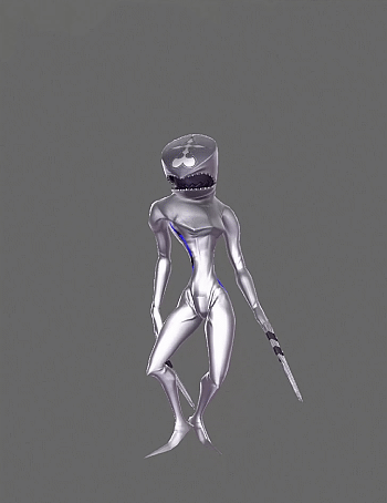
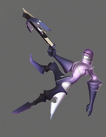
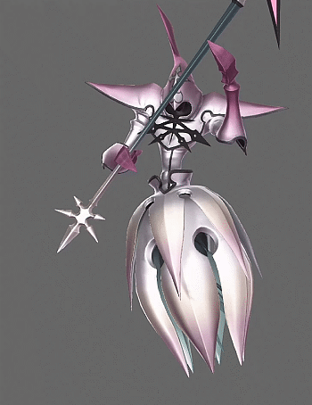

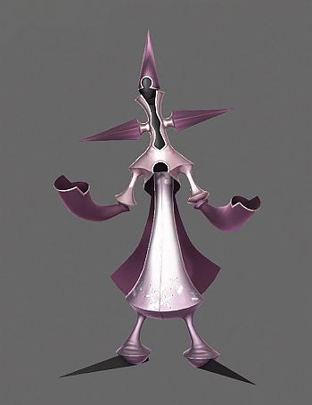
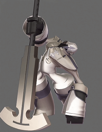

Kingdom Hearts 3 - Nobodies
#kingdom hearts 3#kh3#nobodies#dusk#sniper#reaper#ninja#gambler#berserker#sorcerer#my gif#i'm a nobody enjoyer so of course i'm gonna make another set with them#nobodies are so reflective in this game i wonder if it they were originally intended to look this way#it would have been difficult to visually convey that in the old engine since lighting and shadows were all drawn onto the texture map#but that's not an issue anymore since there are far less lighting and graphical restrictions#anyways i'm glad we got a couple new nobodies#because their designs rule#i love how the one that represents marluxia can morph its body to look like the pod that sora slept in at castle oblivion#while the one that represents larxene has flowy scarf tails that are reminiscent of her unique hairstyle. the knife hands are cool
1K notes
·
View notes
Text
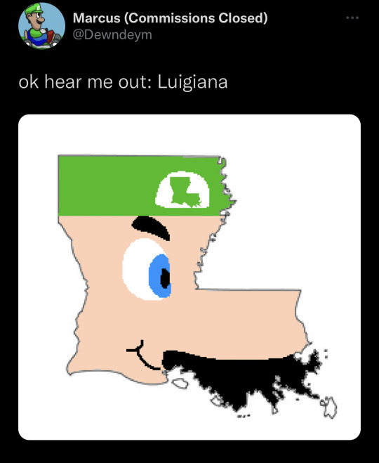
#luigi#mario#nintendo#gaming#video games#funny#lol#humor#meme#louisiana#geography#map#new orleans#super mario odyssey#super mario wonder#switch#nintendo switch#super mario#retro#retrogaming
2K notes
·
View notes
Text
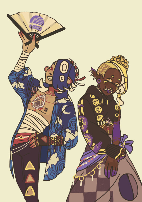

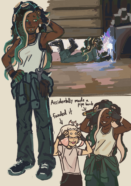
some splat doodles in between doing a bigger project for an irl thing
[IMG ID: Three images of various Splatoon characters. Image 1 features Shiver and Frye in alternative detailed outfits reminiscent of their in-game outfits. Shiver is holding her fan and Frye is grabbing her own arm.
Image 2 is a few various drawings of Frye. Top left is her as the 'sitting cutely' reaction image. Top right is tiny Frye dressed as a 'portly little sailor boy' with a lollipop. Bottom left is a tiny Frye doing a peace sign and bottom right is Frye when she sits down in her splatfest performance doing the finger gun pose.
Image 3 is a page full of Marinas plus one Pearl. Left is a fullbody of Marina in coveralls and a tanktop with gloves and a wrench in her pocket. Upper right is a drawing of Marina welding on the ground and kicking her legs. Below that is Pearl and Marina doing the tongue out hands on head anime pose with the label on Marina saying 'built a pipe bomb.' Pearl's label says 'funded it.' /END ID]
#hi i have a problem of not posting art until i have like 3 different images done#splatoon#shiver#frye#marina iida#pearl houzuki#the frye sitting cutely was PRE her win but now its more relevant#also my irl drawing is DONE BITCH so i am fully free to start drawing whatever i want now#gonna finish this kris drawing next ithink then im..also drawing that pokemon woman ok..i cant resist.#myart#edit: i edited marinas skintone bc the gradient map i put on it made it lighter and its been bugging me#sorry about that#edit 2: in case anyone was wondering those r just tit lines not top surgery lines on shiver transgender yes but wrong way fbhdskjbfk
6K notes
·
View notes
Text

🌻🩵🍃🌖
#dungeon meshi#artists on tumblr#art#illustration#digital art#my art#delicious in dungeon#marcille donato#marcille dungeon meshi#falin x marcille#falin touden#falin dungeon meshi#marcille dunmeshi#delicious in dungeon marcille#girlfriends#I love them your honor#I tried clip studio paint#and gradient maps#have a wonderful day#dungeon meshi fanart#yuri#🩵#short break from tgcf#farcille#dunmeshi
285 notes
·
View notes
Text

not beating the cartographer allegations
#comm for a very patient and very wonderful commissioner of mine!#this was SO satisfying i keep going back and like. looking at it. lmao#map#cartography#map illustration#warrior cats ocs#warrior cats#harriertail#im not a cartographer tho
523 notes
·
View notes
Photo

Timeline and map of the Seven Wonders of the Ancient World
Dates in bold green and dark red are those of their construction and destruction, respectively.
466 notes
·
View notes
Text


Having the time of my life cross referencing these right now. Great resource for fic writers.
Midtown:
Jayce's home
Viktor's home
Hexgates
Airship Dock
Clock Tower
Science Lab
Council Chamber
Science Plaza
Upper Piltover:
Caitlyn's Home
Great Guildhall
Arbor Botanica
Medarda Opera
Low Piltover:
Vi's Apt
Oame(?) Arcade
Sun Gates
Alcove District:
Brewery
Four Sisters
The Fissures (Lanes):
Vander's Bar (Last Drop)
Benzo's Shop
Hospice
The Pumphouse
Sevika's HQ
#arcane#arcane netflix#arcane league of legends#charles lee you will always be famous to me#wonder of the map will be in the art book 👀#piltover lore#zaun lore#love me a good map#league of legends#piltover#zaun#world building#lore
103 notes
·
View notes
Text
thinking about resident evil protagonists having countless maps in their pockets. either folded neatly or just crumpled up.
leon gets lost for the 50th time that hour and scrambles to find the right map, getting out a compass and everything and starts strategizing to find the right path, meanwhile ashley is staring, wide eyed, at the ganados that just came to a freeze as soon as the maps left leon’s pockets
#even funnier if leon doesn’t know how to turn the map right and starts trying to match up the buildings on his map to real lif#ashley just stares at him wondering how he even navigated to spain in the first place#he didn’t. he was escorted there#somehow he’d get on a hijacked plane#proceeds to take over the plane after defeating the bad guys™#crashes the plane right in the ocean. hundreds dead#it’s a miracle he made it this far this is the same dude that can’t reuse a small key on the same locks#resident evil#leon kennedy
169 notes
·
View notes
Text
Worldbuilding: Visual Aids
If your characters are having an intense and possibly complicated discussion, don’t be afraid to have them break out visual aids. I know, that’s something more effective in a visual medium like TV and movies. But having them implies your characters have something they can all point to as they argue, and you can still describe the important parts of a diagram, diorama, blueprint, conspiracy board... or map.
Maps are incredibly handy. Especially when you’ve, say, dumped your characters into an unfamiliar country/world and the locals are trying to figure out where these new guys are from. In case, y’know, there are Unexpected Problems about to crop up. Because politics will kill you faster than monsters....
Maps are interesting because they depend a lot on cultural worldview. How you depict the world and places in it depends a lot on how you think the world should look. Say, putting Jerusalem as the Axis Mundi, or the Middle Kingdom, or the United States. All of these are different worldviews, and the maps can look very off from what we might expect in modern life.
Well. Except that last, likely, because it’s the product of the same Western cartography that mostly won out as “how we portray where things are with maximum accuracy”. Not that any flat map is ever totally accurate, because we live on an oblate spheroid and it is definitely not flat. But we try to minimize how much things are distorted. Which is why a good atlas has several world maps, each with different continents or spots on the globe as “center”, so you can see minimal distortion in any one place of interest.
Okay, you might say, how is this useful in a historical fantasy? After all, you have to go back to the late 1500s in most of the world for good maps, and centuries later in Asia....
Actually, not as late as you might think. Ladies and gentlemen, today I’d like to introduce you to the “Black Tulip of Cartography”, AKA the Kunyu Wanguo Quantu (“A Map of the Myriad Countries of the World”).
This one was printed in 1602, put together by Matteo Ricci and a bunch of his Chinese associates. Ricci believed that one of the first steps to getting Christianity accepted in China was demonstrating that it could accurately depict the world. Hence, maps.
It’s got all the continents, including a fair depiction of the coast of Antarctica. (Even if a few bits of Tierra del Fuego got thrown in.) It’s got little tidbits of info on various places. (The map mentions feral horses in the Americas, and identifies Florida as Huādì (花地), the “Land of Flowers.”) And it more-or-less shows where China, Japan, and Korea are in relation to lands more familiar to Westerners. For the time and info available, it is a really good map.
It’s also one I can legitimately lift for Colors of Another Sky, because historically, at least one copy did get to Korea. Mwah-ha-hah....
10 notes
·
View notes
Text
Kataang Week 2024 DAY 1 // Cultural Sharing
“I’m nervous. Am I doing okay?”
“You’re doing amazing Sweetie.”
#kataangtag#kataang week#kw24#katara#aang#kataracies#avatart#As someone whose hair is a major part of their culture I wanted to lend that to this piece#I think braiding would be wonderful in the hands of Air Nomads women even though the men are all top bald baddies ∠( ᐛ 」∠)_#in my culture Black Americans used hair braiding as a way to navigate. Braiding styles were used as maps to avoid traps and find freedom#and since Air is the element of freedom it felt right 💛🧡#on a lighter note do NOT notice how rusty I am ok HEY WHAT I SAY AHT AHT#I’m so happy I finally got to draw these bubbles braids on someone they are the CUTEST#I will say dating someone from another culture isn’t as hard as people fantasize 😂 I’m just respectful of my partner and eager to learn#I think a lot of that gets lost when people focus to heavily on if one or the other partner doesn’t look like they are 24/7#dripped in another partner’s culture. like a lot of love for the significant other gets missed#but you’ll never lose that love or reverence for you culture and I hope that message comes across in this lil drawing ok byeee (ノ´ヮ´)ノ*: ・゚#ON TO DAY 2#English majors do not come for me I see it’s the wrong *too ITS THE TAGS GIRL WHATCHU WANT ME TO DO
124 notes
·
View notes
Text
in case anyone else is as bad at geography (especially ancient geography) like i am, wikimedia has an awesome map showing where all the notable characters in the trojan war hail from

this is just a section, click through for the much bigger map. (man, sarpedon and pyraechmes travelled FAR)
#now i feel even sorrier for philoctetes. he lived closest to troy and got stuck on the island JUST OUTSIDE#and i never noticed automedon being from skyros! i wonder if he and neoptolemus would talk of home#i have to assume the crosses denote who died at troy but they are not always correct. my man nestor lived WAY longer#tagamemnon#the iliad#the trojan war#maps
94 notes
·
View notes
Text
Loz fandom stop being angsty and give the daydreaming kids on big fun adventures with a cool glowing sword some actual whimsy and joy challenge
#It's like the happy media equals angsty fandom and vice versa but like. Video game series about the dreams and adventures of childhood with#A fandom full of angst and abandonment and depression and smut#It's why I don't really stay in the loz fandom long each time I circle back around#There's so much potential for good things and comfort and snuggly warmth and lightheartedness.#Like yeah messed up things happen in front of and to link but kids are resilient beasts and most importantly they fix it#He's literally wearing the Peter pan hat to invoke that sort of eternal wonder that's the DESIGN of the hat that's why it's so identifiable#Fanart captures it a lot. The gorgeous landscapes and quiet moments and dappled sunlight#But fics???? Oh lu fics are just full of miscommunication and resentment and sour interactions and pain and simmering anger#I prefer to read trusted authors because it's so wearing but the problem is you have to go out and find them lol#It's a very controversial belief of mine that every link enjoyed their adventure even if it was scary or sad and would not be averse to#Another. Oh the circumstances they might hate. But link has never been one to refuse the call#That's the POINT they stepped up when the adults couldn't it's their COURAGE that they'd be fastest to volunteer.#Unrelated but post game botk is adhd central you can do literally whatever you want and whatever pace and you just drift around getting#Distracted and teleporting all over and setting challenges and poking around every nook and cranny#Like botw I had over 300 koroks and 98% map completion. I maxed out hero's path twice over. Totk I've just been wandering around#Speed farming lynels like 17 different goals drifting from one to the other as I wish. Still missing the last 2 sage orbs NO idea where#There's like a million hinoxs now tf#loz#legend of zelda#lu#linked universe#ao3
77 notes
·
View notes
Text


birthday boy got poisoned :(((
Emily Wilde's Map of the Otherlands (Emily Wilde #2) - Heather Fawcett
#this is already very funny#but it would honestly be funnier if this was just a date he picked arbitrarily for his humansona#and not his actual birthday#look me in the eyes and tell me he wouldn't#also he's a virgo#if you were wondering#emily wilde#heather fawcett#emily wilde's map of the otherlands#emily wilde spoilers
69 notes
·
View notes
Text

Did you guys know the concept of community added cosmetics was Bidwell's idea
I like to think he goes through cosmetics himself, with occasional merc input
#my art#beepartcollection#tf2#team fortress 2#tf2 scout#tf2 bidwell#this also makes me wonder if bidwell was the one to add wutville#which is tf2's worst map#i also think he added the corpse carrier while drunk at the company halloween party
108 notes
·
View notes
Text
A Bit of Map Squee
This is not going to be a full book review of Korean History in Maps, edited by Michael D. Shin, because I just got it and have started flipping through it to read. It is going to be some gleeing instead. Because this is an example of a good worldbuilding source, with the kind of information you want to build a basic structure for your story setting.
This is a very recent book (just updated in 2022), meant to go along with courses in Korean history. So the history bits aren’t terribly long, about 10 to 20-odd pages per era depending on how much information we have from archaeology and the historical record. But it is condensed and useful information. What we know about the culture, agriculture, trade and wars of each era. If you wanted to set a story in any particular timeframe in Korea, this book would be a very good place to start building up, “what was it like to live in this place and time?” There are lots of photos of artifacts, including the “knife money” of Old Joseon and the Silla crown, and the maps....
Oh, the maps. Not just squiggly blob maps of “where this kingdom was, we think”. The maps include cities. Fortresses. Known market areas. There’s a topographic map of the peninsula, so you can see all the wrinkly mountains that make this an interesting area for would-be conquerors. There are maps of land and sea trade routes as far as we know them in each era, and what were major items of trade to and from each place the kingdoms interacted with. For the Joseon Dynasty we even have a map of which organizations of merchants traded in which parts of the kingdom. So if you wanted to, say, get a book on medical acupuncture from the Ming Dynasty to Hanseong (Seoul), it’d probably come overland from Shenyang through the Uiju merchants and either down the Korean coast by ship through the Gaeseong merchants, or overland through Pyongyang and then Gaeseong. If you wanted black pepper, though, it’d come in from Japan by way of Tsushima.
The section on Goguryeo (the era The Great Battle movie is set in) has some of the most info I’ve found on that kingdom in one place. Specifically it has where Ansi Fortress (Ansiseong) is. I’ve found other maps locating it before this, but they generally were set in part of the Liaodong Peninsula alone, and so not in scale with the Korean Peninsula. Making putting the two together a headache. This has it all together in the map of Goguryeo. So now I can look at that, and say, “Okay, I’m putting Daehan’s borders here. Which means the Jurchens are over there - north and west of the original timeline. And I have info on what they’d be trading, which helps explain why Nurhaci isn’t as mad at Daehan as he was at Joseon....”
Some of what they’d be trading to the Jurchens is salt, farm equipment, and cows. If you know history, you know salt is a big thing.
And trade flowing means information flowing, and at least a few people moving between places carrying those goods and ideas. If you want to have a feel for how your world works, knowing who is moving what where is an excellent foundation.
4 notes
·
View notes
Last Seen Blogs

2-high-to-cry
× Too high to cry ×

autodakar
اتوداکار autodakar

thesleepyjunebug
Abra Cadaver

spookyleeeed
无标题

crueblr
Untitled