#supercontinent cycle
Explore tagged Tumblr posts
Visit Tumblr Blog
Explore Tumblr blogs with no restrictions, modern design and the best experience.
Last Seen Tumblr Blogs


Fun Fact
Hackers stole 65M passwords from Tumblr in 2013.
Text
Friday 11 October 2024
Grand Strategy Newsletter
The View from Oregon – 310
Permutation of Cyclicality and Linearity
…in which I discuss linear and cyclical history, reductivist formulations of history, Nietzsche’s eternal return, inter-definability of permutations, temporal iterations, uniqueness in time, repetition, plate tectonics, and the supercontinent cycle…
Substack: https://geopolicraticus.substack.com/p/permutations-of-cyclicality-and-linearity
Medium: https://jnnielsen.medium.com/permutations-of-cyclicality-and-linearity-1dead7293ef4
Reddit:

0 notes
Text

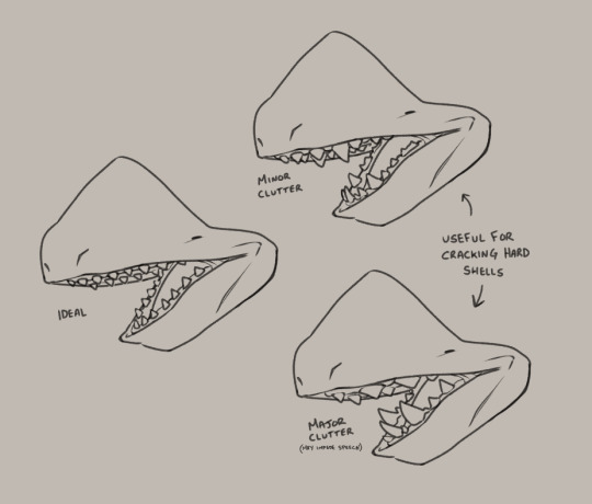
The Audi
Homeplanet: Aodilea (Frontier) Habitat: Temperate Coastal Lifespan: ??? Diet: Mesocarnivore (50-70% meat consumption)
Evolving from ancient oceanic odontocetes off the northwestern coastline of the Frontier supercontinent, the Audi are gentle giants and reknowned for their pride, curiosity, and hospitality. Audi have exceptional hearing and tactile awareness to offset their incredibly poor eyesight that gets worse the older (and larger) they get. They also sport a handsome melon to assist in their own form of echolocation, a frequency too low for the human ear to parse. Species with more delicate hearing have often complained of Audi cities being the one of the most audibly overstimulating experiences due to this rumble being incessantly present.
Audi lack any form of dymorphism, as every individual has the capabilities to become pregnant and induce pregnancy.
More about the Audi life cycle under the cut.
The Audi are (assumedly) the longest-living species of sentient lifeforms in the Laurelai Galaxy. It is difficult to pinpoint age in any Audi due to their complete lack of any calendar system; Audi view time as constantly moving forward instead of cyclically repeating, and age records were never anything of value.
Because of their lack of birth dates, Audi categorize their lives into phases. Their first official phase is childhood, with their lack of an 'infant' category caused by the species having two fetal incubation periods: the first organic and the second synthetic. Audi give birth incredibly prematurely due to their narrow pelvic gap, and, to prevent damage and even death to the parent, birth is induced within a two-to-three month time period. Full fetal growth is achieved at ten to eleven months, with the second incubation period done with the asisstance of advanced medical technology that simulates a natural womb. Due to this technology, Audi's infant mortality rate went from 80% down to 25% with three out of four Audi infants reaching childhood.
The second phase is adulthood. What criteria needs to be met for this phase is up to speculation, as Audi seem keen on keeping that information private. What can be assumed is that it's personal for every Audi, and every Audi reaches adulthood at different times. Height ranges anywhere from 6'8" (203cm) to 9'11" (302cm) on average, with older individuals being on the taller end due to Audi constantly (albeit slowly) growing their entire lives.
The final phase is She, a coveted example of Audi excellence and potential. Reaching the phase of She takes an impossible amount of time and physical growth. Every She, of which there are currently six, has a leadership role, ranging from cultural preservation and the arts to science and engineering, with each She taking a 'mastery' of one of these core values of Audi society. An interesting note is that every She is referred to as 'She', making it difficult for outsiders to deduce which of the six She is being referenced. She cap out the Audi height range at an even 10' (304cm), though why this is considered maximum height or how they suppress growth past this point is still being studied.
#art#speculative biology#laurelai audi#<-a tag to use for every species that exists in this galaxy i've made#they do have clothes of some sort this is just the barbie doll version#and every vague thing in this writing is on purpose i promise there's a reason for all of it
462 notes
·
View notes
Text
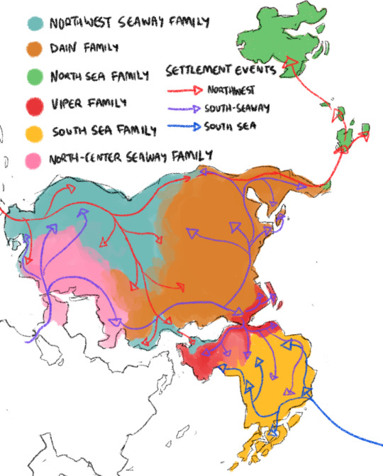
Rough map of the far eastern subcontinent, the contemporary spread of its Major language families, and the (VERY, VERY rough strokes of the) three human migrations that formed the majority of this landmass' population (and initiated the spread of these languages).
There were three major major human settlement events in this area, two of which began during the paleolithic period. These dispersals occurred over a scale of centuries/millennia, and not all at the same time.
Peoples derived from the same settlement group share at least some degree of 'recent' (on the scale of millennia) common ancestry, and descendants of separate settlement groups have at times merged (IE the North Wardi are of mixed proto-Finnic (northwest settlement) and proto-Wardi (south seaway settlement) descent on a population-wide scale (reflecting a complete merger of previously separate populations, rather than mixed ethnicity on individual or sub-population scales)).
-SOUTH SEAWAY SETTLEMENT: Likely the first human settlement event here. Emerged across former land bridge that fully connected this landmass to the rest of the supercontinent. Initiated the spread of the North-center seaway, Dain, and Viper language families.
-NORTHWEST SETTLEMENT: Emerged from across the far northwest Inner Seaway via sea travel. Initiated the spread of the northwest-seaway and north sea language families.
-SOUTH SEA SETTLEMENT: The most recent settlement event (began during the neolithic period). This originated with a group dispersing via sea travel over a 50-100 year period, fleeing rising sea levels in a formerly extant large island chain to the southeast. This is the only settlement event that has any form of historical documentation, via the Migration Cycle body of stories preserved among the Yanti people. Initiated the spread of the South Sea language family.
---
A language family refers to groups of languages descended from a common ancestor, not mutual intelligibility (IE: The Highlands, Finnic, and Keppeji languages are all from the same language family. A Highlands speaker might recognize cognates in the Finnic language, but could not comprehend a Finnic speaker, LET ALONE a Keppeji speaker). Each can be further subdivided into narrower language families (IE: Wardi/Wogan languages form their own family with closer common ancestry than to other Viper language family groups)
The language map should not be taken dead literally and shows approximate areas in which each family is spoken Predominantly, with no nuance for areas of linguistic convergence or the influence of outside language families. It also does not include comparatively minor language families developed in isolation, or major language families with very few representatives on this landmass (ie: Jazaiti language is of the major White Sea language family, not shown on this map).
Here's a (by NO means exhaustive) list of established peoples who speak languages from each family predominantly:
Northwest Seaway language family: Keppej, Korya, Moorlanders, Finns, Hill Tribes, and North Wardi.
Dain language family: Royal Dains, Dainach, Tho-Tykoso, 'Sea Dains', The Floating House, Hrolje.
North Sea language family: Varkhata-Byla, Rodi-Byla, Uswa-Byla, Urswali, Ursvali.
Viper language family: Wardi, Wogan, Cholemdinae, Ubiyan, Askosi, and Uboe.
South Sea language family: Yuroma, Highland Yuroma, Yanti, Losurrwe, Ur-Yamse.
North-center seaway language family: Buweni, Thingarri.
84 notes
·
View notes
Text
I HAD A DREAM ABOUT THE COLLAPSE OF PLATE TECTONICS & IT MADE ME FORGET MY FATHER’S VOICE
i once believed continents were lovers // clinging. clutching. just waiting for the right era to kiss again. then i learned they’re fleeing each other / screaming across the basalt in opposite tongues & i stopped asking questions. (childhood was a failed experiment in believing in unity) // i knew something was wrong with his hands when he gripped the wheel like it might fly away. i counted the calluses. named them after extinction events. jurassic, devonian, permian, daddy’s temper // it doesn’t matter. when you’re small enough to fit in the space between gear shift and glove box, you learn things don’t explode–they erode. he never said sorry, but i remember the air always tasted like burnt clutch and forgotten groceries.
i read once that seismic drift is inevitable. i folded that sentence into the lining of my school skirt, tucked beside the crushed lilac i stole from a neighbour’s yard. for years i believed every crack in the concrete was an omen. some girls learn ballet. i learned how to measure exit velocity by watching the kitchen door slam.
& the tectonic dream. oh god. it began in a lecture hall & ended in the stomach of a sleeping volcano. they were talking about supercontinents. cycles. how we’re destined to crash back together. rejoin. renew. i raised my hand to ask if pain can also return in waves, like geology does, like love does, but the professor was swallowing chalk & the room filled with magma. i woke up with dry mouth and a seismograph scrawled across my thigh in pen.
(it’s still there. the scar that says: don’t trust anything that names itself solid.)
i tell my therapist i feel most safe during natural disasters. she doesn’t laugh. she doesn’t ask why i cried when i saw a sinkhole on the news. she doesn’t ask why i carved a map of the san andreas fault into the back of my notebook. she doesn’t know about the car rides. about how i used to beg the earth to split. i wanted to be swallowed whole by something that didn’t need a reason.
#things i wrote#poetry#original poem#poem#spilled ink#poems#poems and poetry#female poet#female poets#poet#poets on tumblr#poetic#poetblr#spilled poetry#writers and poets#poems on tumblr#writeblr#writers on tumblr#writers#writer#writerscommunity#creative writing
33 notes
·
View notes
Text
indianapolis really is the most crossroads ass city. you'll be sitting at the bus stop talking to someone about their lost loved one or the job they're applying for or how their children are all moving away from home and this guy will come up and ask for coins to cross the river styx. and it's like man. i think the type of coin you need went out of circulation back when this was a supercontinent. there was an article in the newspaper about it and everything. can't you remember? we've tried everything. we've been to the coin expo at the fairgrounds and even the philatelist in case he knew something. and all of the coins we've tried pass straight through your palm. here, watch. see? i'm sorry. somebody should really call the mayor's action line or something. and they do, and the mayor commissions another pensive thinkpiece about the guy who needs two coins to cross the river styx and the cycle begins anew
159 notes
·
View notes
Text
⋯ paleontology themed id pack !!

names ⁘
fossil ⋄ trilo ⋄ dino ⋄ cambria ⋄ amber ⋄ nuna ⋄ shale ⋄ marrella ⋄ archo ⋄ azhdarcho ⋄ strata ⋄ phyla ⋄ devon(ia) ⋄ mosa ⋄ darwin ⋄ finch ⋄ kimberella ⋄ pteraspi ⋄ stega ⋄ raptor ⋄ burgess ⋄ holocene ⋄ lichida ⋄ luca ⋄ zircon ⋄ ediacara
trilo: as in trilobite | cambria: the cambrian period | amber: where many insects are preserved | nuna: one of the oldest supercontinents | archo: as in archosaur | azhdarcho: as in a group of large pterosaurs | strata: as in stratigraphy | devonia: the devonian period | finch: darwin's finches | stega: as in stegosaur | burgess: the burgess shale, british columbia | lichida: a group of trilobites | luca: last universal common ancestor | zircon: a crystal that can help search for early microbial life | ediacara: the ediacaran period

pronouns ⁘
paleo/paleo ⋄ fossil/fossils ⋄ dig/digs ⋄ dino/saur ⋄ dino/dinos ⋄ geo/geology ⋄ phy/phylum ⋄ tri/trilobite ⋄ bone/bones ⋄ mammoth/mammoths ⋄ flora/fauna ⋄ zo/zoa ⋄ tetra/tetrapod ⋄ evo/evolve
titles ⁘
The Most Ancient ⋄ (prn) Who Swims with Ichthyosaurs ⋄ The Fossilized One ⋄ (prn) Who is Encased in Stone ⋄ The Ancestor of Life ⋄ The Driver of Evolution
system names ⁘
the burgess shale ⋄ the fossil dig ⋄ the cycling lands ⋄ prehistoric pack ⋄ mesozoic menagerie ⋄ the index ⋄ heart of ediacara
As a certified paleontology nerd with a tattoo of a cheirurus trilobite and an anomalocaris.... this was absolutely necessary. -Iris (she/her)
credit: 1, 2
#cosmozoa— id pack 🌌#id pack#endo friendly#mogai friendly#name ideas#name suggestions#pronoun ideas#pronoun suggestions#system names#titles#npt#npts#npt list#npt ideas#npt suggestions#title suggestions#name list#neopronouns#noun names#unique names
144 notes
·
View notes
Text
I wrote this at one in the morning because my head was going to burst. Have some updated countryhumans/nationhumans mythos
—————————————
Deity Hierarchy:
Archons
-Fickle creator-Gods with moral compasses based on their field of control
-Intersex
-Faces and bodies of Beasts
-Has Citadel
Children of Archons
-Nationhumans and all life. NHs tend to be more powerful because of Taewaih
Archetype
-Moneto
—————————————
Earth's primary Archons (major gods, usually primordial)
Tutyāni {Tut yani}(the whole or "total earth", Reuwanwey's mate and Taewaih's parent)
Reuwanwey {rue-wan-wey} (sun, Tutyāni's mate and Taewaih's parent)
Ouioti {oi-oati}(ocean, Muitun's mate)
Muishin (moi-shīn}(moon, Ouioti's mate)
Sōnti {So-nti} (daylight sky, No'onta's mate)
No'onta {Nō'ōnta} (night sky, Sōnti's mate)
Taewaih {Tae-wā} (last manifestation of a contiguous, united supercontinent)
————————————
Creation story
Taewaih , the last known manifestation of the lands united. Her core was hot and dry, but the precious rhythm and breath of life lie, given to her by Reuwanwey, within. Her outer parts faced the Ouioti (ocean), which nourished the non human life she breathed into. She is mighty and benevolent.
She knew that something was missing- mortal souls that could be the stewards of her creation. She made uncountable figures; made of Tutyani's flesh, sunbeams of Reuwanwey, water of Ouioti, falling stars of Muishin, stardust of No'onta, and clouds of Sōnti.
All Archons looked upon this creation, satisfied but confused by its purpose. It was not unlike them to create mountains, hills, rivers, deserts, crators from falling stars and tides from push and pull. What did their youngest member have in mind? Did she still have a mind?
She built a powerful fire in her core, second only to Reuwanwey's own sweltering form, and breathed her wind into the noses until their earthen chests rose and fell with the rhythm of life. She placed each in rows in her bosom to bake. Their bodies seemed to crack, burst and deform. Taewaih knew there was an essence of life only she could give. She distracted Sōnti, telling them their beloved mate, No'onta, prepared their bed for the night. She stole Sōnti's heavenly lighting and opened her body at the throat.
As her blessed blood touched the clay figures, they began to resemble her, embody her. Her life and mind left her, only to enter new vessles where she lived again. The other Archons were afraid of the sacrifice, but they knew that ever-benevolent, ever-wise Taewaih had made creatures capable of love beyond themselves, and good stewards to all life.
Long after, when the clay became soild and strong but could not yet move on it's own, Archons created creatures these new pieces of Taewaih would become keepers of when they woke up.
She broke the cycle of reincarnation by creating NHs, thus sacrificing herself to bring forth life and creation and living through her spiritual children. Humans were created in her image alike her children, and became the primary life stewarded by NH.
———————————-
Tut'sentaewaih (Tut'sen-tae-wa) -To be realized; self-actualization; to become one or whole
This is the concept of becoming closer to Taewaih as she was. It means to experience partial or whole ego death- to hold an unwavering sense of agape for a NH's people, those outside of their country, and all the life of the world. "Complete" Tut'sentaewaih is only achieved by all NH coming to this sense of agape and experiencing collective ego death
#countryhumans#original character#original characters#digital art#my art#countryhuman#mythology and folklore#fictional characters#intersex characters#intersex
3 notes
·
View notes
Text

Relics of a Red World in Bighorn Basin
During the Triassic Period, about 220 million years ago, the present-day continent of North America was part of the supercontinent Pangea. Commensurate with Pangea’s tremendous size, its weather patterns also achieved large scales. Scientists think the tropical zones of this giant landmass experienced “megamonsoons” in this period, setting up fluctuations between extreme wet and dry seasons.
These cycles of wetting and drying are believed to have oxidized, or rusted, sediments across vast areas. The resulting rock layers, commonly referred to as “red beds,” take their color from the mineral hematite and now appear on several continents. In North America, the rusted Triassic rocks show up in a handful of places, including Bighorn Basin in northern Wyoming and southern Montana. This oval-shaped basin, approximately 150 miles (240 kilometers) long and 80 miles (130 kilometers) wide, is encircled by six mountain ranges and is rich in both fossils and oil and gas reservoirs.
Sharp folds of the distinct reddish Chugwater Formation cut across the image above, acquired with the OLI-2 (Operational Land Imager-2) on Landsat 9 in June 2024. In the tens of millions of years since the Chugwater’s Triassic conception, the Pangean supercontinent fragmented, and landmasses recombined. The sedimentary rock layers seen here were folded and tilted in the continental collisions that created the Rocky Mountains. These folds are located near the northern end of Bighorn Basin; other outcrops of the Chugwater appear in the basin, often along its perimeter.

This jagged streak of red rock intersects with Bighorn Canyon. The canyon makes a gouge in the landscape as it extends north into Montana, with depths reaching up to 2,500 feet (760 meters). Bighorn Canyon National Recreation Area, outlined in the image above, was established in 1966 after the Bureau of Reclamation constructed Yellowtail Dam on the Bighorn River and created a lake more than 70 miles (110 kilometers) long.
The recreation area encompasses a wide range of natural and cultural wonders. Researchers have discovered fossils dating back to the Jurassic Period within its boundaries. Today, the shrubland, woodland, and steppe habitats are home to wildlife such as bighorn sheep, wild horses, and coyotes. Artifacts along parts of the Bad Pass Trail, traveled by Native Americans for thousands of years, are preserved within the park. Now, more than 200,000 people visit the area each year for hiking, boating, fishing, and other activities.
NASA Earth Observatory images by Wanmei Liang, using Landsat data from the U.S. Geological Survey. Story by Lindsey Doermann.
2 notes
·
View notes
Text
The burning Gondwana! | Gondwana em chamas!
🇬🇧
Finally, my favorite time interval! My studies in paleobotany focus on the Upper Paleozoic, and today I bring to you this paleoenvironment that illustrates what the Permian-Carboniferous was like in Gondwana. Drawing fire is always a challenge, but I really enjoyed the outcome. I sped up the time-lapse because the video ended up being really long. Each tiny leaf was drawn individually, which made the video a bit less dynamic in the end, but it was a very cool creative process.
I dedicate today's post to Dr. André Jasper. Jasper is one of the earliest Brazilian paleobotanists to dedicate his life to studying paleovegetational fires in the Upper Paleozoic of Gondwana. He is one of the leading global experts in the study of charcoal and fire dynamics in the Paleozoic and Mesozoic eras.
Let’s get started! 🔥
The Permian-Carboniferous, also known as the Late Permian, is a division of the Permian geological period that occurred approximately between 298.9 million and 251.902 million years ago. During this period, Earth was united into a single supercontinent called Pangaea, which consisted of two main landmasses: Laurasia in the north, and Gondwana in the south.
The flora of the Permian-Carboniferous was dominated by a wide variety of plants, including ferns, lycophytes, horsetails, and the first gymnosperms (seed-bearing plants). These plants formed dense forests in many parts of the world, especially in tropical and subtropical regions.
Paleovegetational fires in Gondwana refer to forest fires that occurred during the Permian in the forests of the supercontinent Gondwana. These fires are identified through geological evidence, such as coal layers, which are formed from carbonized plant material. These fire events were influenced by a combination of environmental factors, including dry climate conditions, the presence of combustible biomass, and volcanic activity.
Paleovegetational fires in Gondwana played a significant role in the evolution of plants and forest ecology during the Permian. Forest fires may have promoted the adaptation of some plant species to fire conditions, leading to the development of features such as fire-resistant bark and the ability to regenerate after fires.
At this point in geological time, the planet is transitioning from a climatic cycle of Ice-house (cooling, with presence of ice at the poles) to a Green-house (warming, absence of ice at the poles). This ultimately leads to the demise of peat bog systems in many regions of Gondwana, causing many plant species to no longer occur during the Permian.
🇧🇷
Finalmente meu intervalo de tempo favorito! Meus estudos na paleobotânica se concentram no Paleozóico superior, e hoje trago para vocês esse paleoambiente que ilustra o que foi o Permo-Carbonífero no Gondwana. Desenhar fogo é sempre um desafio mas, gostei muito do resultado. Acelerei o time-lapse porque o vídeo ficou realmente longo. Cada pequena folha foi desenhada individualmente, o que deixou o vídeo pouco dinâmico no fim mas, foi um processo criativo muito legal.
Dedico a postagem de hoje ao Dr. André Jasper. Jasper é um dos primeiros paleobotânicos brasileiros a dedicar sua vida estudando os paleoincêndios vegetacionais no Paleozóico Superior do Gondwana. É uma das grandes referências mundiais em estudo de charcoal e dinâmica do fogo no Paleozóico e no Mesozoico.
Vamos começar! 🔥
O Permo-Carbonífero, também conhecido como Permiano Superior, é uma divisão do período geológico Permiano, que ocorreu aproximadamente entre 298,9 milhões e 251,902 milhões de anos atrás. Durante este período, a Terra estava unida em um único supercontinente chamado Pangeia, que consistia em duas massas de terra principais: Laurásia, no norte, e Gondwana, no sul.
A flora do Permo-Carbonífero era dominada por uma grande diversidade de plantas, incluindo samambaias, licopódios, esfenófitas e as primeiras gimnospermas (plantas com sementes nuas). Essas plantas formavam densas florestas em muitas partes do mundo, especialmente nas regiões tropicais e subtropicais.
Os paleoincêndios vegetacionais do Gondwana referem-se aos incêndios florestais que ocorreram durante o Permiano nas florestas do supercontinente Gondwana. Estes incêndios são identificados através da evidência geológica, como camadas de carvão, que são formadas a partir de material vegetal carbonizado. Esses eventos de incêndio eram influenciados por uma combinação de fatores ambientais, incluindo condições climáticas secas, presença de biomassa combustível e atividade vulcânica.
Os paleoincêndios vegetacionais do Gondwana tiveram um papel significativo na evolução das plantas e na ecologia das florestas durante o Permiano. Incêndios florestais podem ter promovido a adaptação de algumas espécies de plantas a condições de fogo, levando ao desenvolvimento de características como cascas resistentes ao fogo e capacidade de rebrota após incêndios.
Neste momento do tempo geológico, o planeta está saindo de um ciclo climático de Ice-house (resfriamento, com presença de gelo nos polos) para um Green-house (aquecimento, ausência de gelo nos polos). Isso acaba resultando no fim dos sistemas de turfeira presentes em muitas regiões do Gondwana, levando muitas espécies vegetais a não mais ocorrerem durante o Permiano.
#science#paleontology#geology#universe#earth#paleobotany#biology#digital painting#space#artwork#arte digital#artists on tumblr#original art#art process#my art#digital art#art#paleozóico#paleomedia#paleobotânica#paleoarte#paleozoic#paleontologia#paleoart#paleostream
9 notes
·
View notes
Note
The oldest material found in the Solar System is dated to 4.5682+0.0002
−0.0004 Ga (billion years) ago.[35] By 4.54±0.04 Ga the primordial Earth had formed.[36] The bodies in the Solar System formed and evolved with the Sun. In theory, a solar nebula partitions a volume out of a molecular cloud by gravitational collapse, which begins to spin and flatten into a circumstellar disk, and then the planets grow out of that disk with the Sun. A nebula contains gas, ice grains, and dust (including primordial nuclides). According to nebular theory, planetesimals formed by accretion, with the primordial Earth being estimated as likely taking anywhere from 70 to 100 million years to form.[37]
Estimates of the age of the Moon range from 4.5 Ga to significantly younger.[38] A leading hypothesis is that it was formed by accretion from material loosed from Earth after a Mars-sized object with about 10% of Earth's mass, named Theia, collided with Earth.[39] It hit Earth with a glancing blow and some of its mass merged with Earth.[40][41] Between approximately 4.1 and 3.8 Ga, numerous asteroid impacts during the Late Heavy Bombardment caused significant changes to the greater surface environment of the Moon and, by inference, to that of Earth.[42]
Earth's atmosphere and oceans were formed by volcanic activity and outgassing.[43] Water vapor from these sources condensed into the oceans, augmented by water and ice from asteroids, protoplanets, and comets.[44] Sufficient water to fill the oceans may have been on Earth since it formed.[45] In this model, atmospheric greenhouse gases kept the oceans from freezing when the newly forming Sun had only 70% of its current luminosity.[46] By 3.5 Ga, Earth's magnetic field was established, which helped prevent the atmosphere from being stripped away by the solar wind.[47]
As the molten outer layer of Earth cooled it formed the first solid crust, which is thought to have been mafic in composition. The first continental crust, which was more felsic in composition, formed by the partial melting of this mafic crust.[49] The presence of grains of the mineral zircon of Hadean age in Eoarchean sedimentary rocks suggests that at least some felsic crust existed as early as 4.4 Ga, only 140 Ma after Earth's formation.[50] There are two main models of how this initial small volume of continental crust evolved to reach its current abundance:[51] (1) a relatively steady growth up to the present day,[52] which is supported by the radiometric dating of continental crust globally and (2) an initial rapid growth in the volume of continental crust during the Archean, forming the bulk of the continental crust that now exists,[53][54] which is supported by isotopic evidence from hafnium in zircons and neodymium in sedimentary rocks. The two models and the data that support them can be reconciled by large-scale recycling of the continental crust, particularly during the early stages of Earth's history.[55]
New continental crust forms as a result of plate tectonics, a process ultimately driven by the continuous loss of heat from Earth's interior. Over the period of hundreds of millions of years, tectonic forces have caused areas of continental crust to group together to form supercontinents that have subsequently broken apart. At approximately 750 Ma, one of the earliest known supercontinents, Rodinia, began to break apart. The continents later recombined to form Pannotia at 600–540 Ma, then finally Pangaea, which also began to break apart at 180 Ma.[56]
The most recent pattern of ice ages began about 40 Ma,[57] and then intensified during the Pleistocene about 3 Ma.[58] High- and middle-latitude regions have since undergone repeated cycles of glaciation and thaw, repeating about every 21,000, 41,000 and 100,000 years.[59] The Last Glacial Period, colloquially called the "last ice age", covered large parts of the continents, to the middle latitudes, in ice and ended about 11,700 years ago.[60]
Chemical reactions led to the first self-replicating molecules about four billion years ago. A half billion years later, the last common ancestor of all current life arose.[61] The evolution of photosynthesis allowed the Sun's energy to be harvested directly by life forms. The resultant molecular oxygen (O2) accumulated in the atmosphere and due to interaction with ultraviolet solar radiation, formed a protective ozone layer (O3) in the upper atmosphere.[62] The incorporation of smaller cells within larger ones resulted in the development of complex cells called eukaryotes.[63] True multicellular organisms formed as cells within colonies became increasingly specialized. Aided by the absorption of harmful ultraviolet radiation by the ozone layer, life colonized Earth's surface.[64] Among the earliest fossil evidence for life is microbial mat fossils found in 3.48 billion-year-old sandstone in Western Australia,[65] biogenic graphite found in 3.7 billion-year-old metasedimentary rocks in Western Greenland,[66] and remains of biotic material found in 4.1 billion-year-old rocks in Western Australia.[67][68] The earliest direct evidence of life on Earth is contained in 3.45 billion-year-old Australian rocks showing fossils of microorganisms.[69][70]
During the Neoproterozoic, 1000 to 539 Ma, much of Earth might have been covered in ice. This hypothesis has been termed "Snowball Earth", and it is of particular interest because it preceded the Cambrian explosion, when multicellular life forms significantly increased in complexity.[72][73] Following the Cambrian explosion, 535 Ma, there have been at least five major mass extinctions and many minor ones.[74] Apart from the proposed current Holocene extinction event, the most recent was 66 Ma, when an asteroid impact triggered the extinction of non-avian dinosaurs and other large reptiles, but largely spared small animals such as insects, mammals, lizards and birds. Mammalian life has diversified over the past 66 Mys, and several million years ago, an African ape species gained the ability to stand upright.[75][76] This facilitated tool use and encouraged communication that provided the nutrition and stimulation needed for a larger brain, which led to the evolution of humans. The development of agriculture, and then civilization, led to humans having an influence on Earth and the nature and quantity of other life forms that continues to this day.[77]
YESSSS, FEED ME KNOWLEDGE
(Did you copy and paste from Wikipedia)
(And I’m also writing this in school😈)
2 notes
·
View notes
Text
Time into space, or if the history of Earth were a path 10 km long
(note: 1 km is about 2/3 of a mile, 1 m is just over 3 ft, 25 mm go into an inch)
Suppose the whole span of Earth's history, from its formation 4.56 billion years ago to its engulfment by the dying Sun 7.59 billion years in the future, is converted into a path 10 kilometers long.
On such a scale, a billion year corresponds to about 800 meters, a century to 0.08 millimeters, and a single year to 0.8 micrometers -- the length of an average bacterium. The present 21st century would correspond to the thickness of a single paper sheet standing upright about 3/8 of the way from the path's starting point.
Looking back from that standing paper sheet, you would have to go back a single millimeter to reach the time of the united Roman Empire, which had begun roughly half a millimeter before. The end of the latest glaciation and the beginnings of Near Eastern agriculture would stand a further centimeter back. Our species started spreading outside of Africa 6.5 cm before the standing sheet, and diverged from the line of Neandertals about 30 cm back.
You would have to walk 5 meters to reach the point where out line diverged from that of chimpanzees. Then other 50 meters to reach the extinction of dinosaurs, and then other 140 to reach their first appearance as Pangea started to split. From the standing sheet, walking a total of 300 meters would bring you to the appearance of animals on dry land, and 450 to the Cambrian Explosion. Walking a full kilometer backward would take you to the first multicellular algae, and two kilometers to the time when oxygen started to build up in Earth's atmosphere for the first time. Beyond that point, you'd meet only bacteria. 3.75 km would take you back to the very beginning of the path, when Earth congealed out of rings of dust surrounding the early Sun.
Walking in the opposite direction from the paper sheet that marks this century, we can probably expect new glacial cycles over the next meter, and a new Pangea-like supercontinent to form between 80 and 200 meters from it. You have a much longer way (6.25 km) to go all the way to our final reabsorption by the Sun, but only about one kilometer before our star's expansion causes Earth's oceans to boil off. Beyond that, all bets are off.
5 notes
·
View notes
Text
The Prophet's Unlikely Prelude to Pangea Ultima
Lo, in the days of my youth, long before my visage was etched with the lines of prophecy and worry, I found myself in an odd predicament that foretold of my future musings on the fate of a world far beyond my time. A peculiar passion, nay, a curiosity most bizarre, led me down a path that culminated in the writing of "Jeremiah’s Lament: Climate Catastrophe and Mammalian Doom on Future Supercontinent Pangaea Ultima."
It all began on a day most unremarkable, under the sweltering sun of the Judean desert. Whilst wandering in contemplation of the divine, I stumbled upon a gathering most peculiar: a convocation of creatures, great and small, engaged in what can only be described as a parliamentary debate. The topic of their spirited discourse? The future climatic conditions of a land yet to be, known to them, by some prophetic insight or perhaps divine jest, as Pangaea Ultima.
At first, I thought the sun had overcome my senses, or perhaps a vision from the Almighty had descended upon me. But as I listened, hidden behind a date palm, the earnestness of their exchange became apparent. A camel, sagacious and long-lashed, spoke with grave concern about the forecasts of unbearable heat, while a jackal, quick-witted and sharp-tongued, argued for the innovation of burrows with air-conditioning, a concept so far ahead of its time that it left me bewildered.
Their debate, laced with humor yet underpinned by a somber recognition of their own mortality, sparked within me a fascination with the future of our planet. How could it be that these creatures, whom I had always viewed as part of the landscape rather than participants in it, held such profound concerns for the world to come?
Driven by this newfound curiosity, I embarked upon a quest unlike any prophet before me. I consulted scrolls and studied the stars, seeking knowledge of this distant future. I learned of the movements of continents, the cycles of climate, and the fate of the mammalian kin I had heard debate under that desert sun.
Years turned to decades, and my beard grew long and white as I toiled over parchments, piecing together a narrative that would bridge the wisdom of the ancients with the revelations of the future. I foresaw a world where science and prophecy intertwined, where the fate of all creatures, great and small, hung in the balance amidst rising temperatures and changing landscapes.
Thus, with a quill fashioned from the feather of a bird that had listened intently to the desert debate, I penned "Jeremiah’s Lament." It was a work born of an unexpected assembly, a humorous encounter that had unveiled to me the interconnectedness of all things, and the importance of looking beyond the present to the future that awaits.
In this manuscript, I sought not only to warn of the impending climatic trials but to honor the spirited debate of my desert interlocutors. For in their humorous yet earnest discourse lay the seeds of a truth too important to ignore: that the fate of our world is a shared concern, spanning species and epochs.
And so, dear reader, as you peruse the pages of my lament, remember the camel and the jackal, the parliament under the palm. Their debate, as whimsical as it may have seemed, was a harbinger of the serious contemplation we must all engage in when considering the future of our planet.
For in the end, it is not just the fate of mammals on Pangaea Ultima that we must ponder, but the legacy we leave for all generations to come, be they prophet, peasant, or pangolin. May my words serve as a bridge between epochs, a testament to the power of curiosity, and a reminder that sometimes, the most profound truths are revealed in the most unexpected of gatherings.
#climate change#climate crisis#climate action#climate catastrophe#climate emergency#science education#environment#Pangaea Ultima
0 notes
Text

@POETICandFUNNY: The story of the gömböc begins with a brilliant mathematician named Vladimir Arnold, who proved in 1995 that such a shape could exist. He did not make it or see it. He just knew it was possible, because he was good at math. He wrote down his proof and showed it to other smart people, who nodded and agreed. But nobody knew how to make this shape. Nobody knew what it looked like. Nobody knew if they would ever find it in the real world. That’s where two Hungarian engineers, Gábor Domokos and Péter Várkonyi, came in. They were fascinated by Arnold’s proof and decided to take on the challenge of finding the exact formula for the shape. They used computers and calculators and lots of paper to solve the puzzle. They named it the gömböc, after a word for a round dumpling, because they liked dumplings.

Ancient diamonds hold the secrets of how continents evolved Diamonds found in Brazil and Western Africa reveal the history of an ancient supercontinent. The secrets of how continents grew and moved throughout the early history of life on Earth have been revealed by the analysis of ancient, superdeep diamonds discovered in mines in Brazil and Western Africa. Tracing the complex history of the ancient supercontinent Gondwana These diamonds developed at the foundation of the supercontinent Gondwana between 650 and 450 million years ago. Supercontinents are large landmasses that are formed when many continents combine to form a single, massive location. Gondwana is one of the most notable ancient supercontinents. It existed from the Neoproterozoic to the Cenozoic era and included the landmasses that now make up South America, Africa, Antarctica, India, Australia, and the Arabian Peninsula. Now, isotope analyses of the tiny silicate and sulphide inclusions in the diamonds have revealed how this supercontinent formed, stabilized, and moved around the planet. “Superdeep diamonds are extremely rare and we now know that they can tell us a lot about the whole process of continent formation,” said Dr Karen Smit of the Wits School of Geosciences, who was part of the study. “We wanted to date these diamonds to try and understand how the earliest continents formed.” Diamonds are one of the very rare minerals resistant enough to survive and witness the supercontinent cycle. The supercontinent cycle involves the recurring construction and dissolution of supercontinents over hundreds of millions of years. It is driven by the movement of tectonic plates, which are large sections of the Earth's lithosphere that float on the semi-fluid asthenosphere beneath them. When paired with current plate tectonic models of continent migration, geochemical analysis and dating of the diamonds revealed that the materials formed at extremely deep levels beneath Gondwana between 650 and 450 million years ago, when the supercontinent covered the South Pole, explained Smit. A complicated history that reveals the origins of ancient supercontinents Diamonds have travelled incredibly far both vertically and horizontally within the Earth, as evidenced by their complicated history, which can be used to trace both the origins of the supercontinent and the last stages of its evolution. What the researchers found was that host rocks containing the diamonds were added to the supercontinent's base, and Gondwana effectively "grew" from below. Violent volcanic eruptions then transported the diamonds to Earth's surface 90 million years ago, and with them the secrets of how Gondwana may have formed. “We need this type of research to understand how continents evolve and move. Without continents there wouldn’t be life. This research gives us insight into how continents form, and it links to how life evolved and what makes our planet, Earth, different from other planets,” concluded Smit. Smit is currently working at the University of the Witwatersrand where she is a member of a team creating a new isotope lab and procedures to eventually conduct diamond inclusion analysis in South Africa.
0 notes
Text
Sea of Tranquility - Emily St John Mandel
Humour did remind me somewhat of Saki's Reginald, though whether that was intentionally inspired or just my brash linking I can't say.
I loved the descriptions of the wilderness – I loved the cyclicity of the ending of civilisation. Admittedly I am partial to cyclicity; even in the context of geology we have supercontinent cycles and I do quite like the idea of destruction/reconstruction etc etc.


1 note
·
View note
Text
Geologists challenge conventional view of Earths continental history stability with new study
In a study led by Illinois geology professor Lijun Liu, researchers used previously collected density data from the Earth’s uppermost rigid layers of crust and mantle — known as the lithosphere — to examine the relationship between craton surface topography and the thickness of their underlying lithosphere layer. The results of the study are published in the journal Nature Geosciences. The lack of deformation within the cratons since their formation makes them the longest-lived tectonic units on Earth — surviving supercontinent cycles like the formation and breakup of the supercontinent Pangea, as well as the lesser-known and more ancient supercontinent Rodina, the study reports. “It is generally accepted that the cratons are protected by their thick underlying mantle roots, or keels, which are believed to be buoyant and strong and thus stable over time,” Lui said. Several recent papers from Liu’s research group directly challenge this wisdom by showing that these mantle keels are actually quite dense. In a 2022 study, the team demonstrated that the traditional view of buoyant craton keels implies that most of the Earth’s cratons would be sitting about 3 kilometers above the sea surface, while in reality, their elevation is only a few 100 meters. This requires the lithospheric mantle below the crust to be of high enough density to pull the surface down by about 2 kilometers, Liu said. In another study, the team used gravity field measurements to pinpoint the density structure of the craton keels to find that the lower portion of the mantle keel is most likely where the high-density material resides, implying a depth-increasing density profile below the cratons. In the new paper, the team shows that the lower portion of the mantle keel that has a high density and tends to repeatedly peel away from the lithosphere above when mantle upwellings, called plumes, initiate supercontinent breakup. The peeled-off — or delaminated — keels could return to the base of the lithosphere after they warm up inside the hot mantle. “The whole process is like what happens in a lava lamp, where the cool material near the surface sinks and the warm material near the bottom rises,” Liu said. This deformation history is expressed in some of the more puzzling geophysical properties observed in the lithosphere, the study reports. “For example, the repetitive vertical deformation of the lower half of the mantle keel allows the seismic waves that vibrate the rock vertically to travel faster, compared to the upper half of the keel, which experienced less vertical deformation,” Liu said. The team also determined that mantle delamination will cause the craton surface to rise, leading to erosion. “This is reflected in the strong dependence of crustal thickness on lithospheric thickness, an observation never made before this study,” Liu said. “In particular, there are two major uplift and erosion events in the past, when supercontinents Rodinia and Pangea each separated, the former causing what is known as the Great Unconformity — a feature in the Earth’s rock record shows no evidence of new deposition, only deep craton erosion. This is the reason why we see pieces of ancient lower crust exposed at the craton’s surface today.” With the help of numerical simulations, the team said that this episodic deformation style of the lower craton keels is how the craton crusts survived the long geological history. “We believe this newly hypothesized lifestyle of cratons will significantly change people’s view on how continents evolve and how plate tectonics operate on Earth,” Liu said. Illinois geology professor Craig Lundstrom and Illinois graduate students Yaoyi Wang, Zebin Cao, Lihang Peng and Diandian Peng; and Chinese Academy of Sciences professor Ling Chen contributed to this study. The National Science Foundation and the National Natural Science Foundation of China supported this research.
0 notes
Text
I think probably the reason conworlders tend to avoid "everything is one supercontinent" scenarios is because of the temptation to go "but more continents = more biodiversity and also means you can do journeys across the ocean to uncharted lands and all that cool stuff."
Which is a shame because there is actually a lot of room for complex coastlines on a supercontinent. They're not static things. If it's just starting to break apart there can be long, narrow seas extending far inland along the paths of the new rifts, and/or long chains of lakes (we have one on Earth today: the Red Sea and East African Rift system. Note that as far as intelligent life goes, the East African Rift Valley is considered a likely "cradle of humanity" so make of that what you will)
If it's being assembled, you can get long narrow ocean basins that are in the final stages of closing, or even isolated seas that have become totally landlocked. Again we have examples on Earth today: the Mediterranean Sea, Black Sea, and Caspian sea are the last remnants of an ancient ocean, the Tethys, which is closing as Earth's next supercontinent takes shape. This process has been going on for a long time: the southern half of Eurasia is built up of multiple layers of microcontinents and terranes that have rifted off Gondwana and collided with the northern "core" that was formed from Baltica, Kazakhstania, and Siberia. Africa, Arabia, and India are just the latest set.
Then there are marine transgressions: our current sea level is relatively low for Earth's history, and as a result we're accustomed to not having large portions of the continents covered by shallow seas, but that's not really typical. We have the Hudson Bay and Baltic sea, but nothing to rival something like the Western Interior Seaway. IIRC supercontinents usually have relatively low sea levels because one single global ocean with mostly old crust tends to be deeper on average than a world with multiple younger, shallower ocean basins, but you can still have large epicontinental seas that could divide a supercontinent into sections, bring more moisture to its climate, or even split it up into multiple separate landmasses even if the continents are all merged.
And you can and do get all of those things happening at the same time. You can have bits of a supercontinent rifting of even while it's being assembled (e.g. Africa and Arabia are colliding with Eurasia, but also have active rifting going on). Here are some snapshots of our most recent supercontinent, Pangaea, throughout its history. All images are from Colorado Plateau Geosystems, Inc. at DeepTimeMaps.com and are used for educational purposes under the Fair Use Doctrine.
Here is Pangaea 320 million years ago, during the Pennsylvanian Period. Gondwana, an enormous ancient continent that has existed throughout the last supercontinent cycle, is colliding with the other major continent, called Euramerica or Laurussia. This was formed more recently from Laurentia (the core of North America) colliding with Baltica (northern Europe) and some other microcontinents. In the North, Siberia and I think Kazakhstania are merging with it as well in the Uralian Orogeny. There's also more small landmasses that rifted off of Gondwana's northern margin earlier in the Paleozoic. There's a big gulf where Southwestern North America will be, inland sees in western South America and northwestern Africa, more shallow seas along northern Gondwana, and a seaway cutting through central Asia. The Proto-Andes mountains are basically a long peninsula while the Amazon and Parana basins are largely covered by shallow seas.

Here's Pangaea 280 million years ago during the early Permian. Some of the inland seas have closed, but there's still some cool gulfs and peninsulas in southwestern North America and a seaway through Laurussia. Isolated microcontinents are still drifting around. Those inland seas in northern Gondwana are now becoming a full fledged ocean basin, as a chain of massive islands rifts off and starts its journey northward across the Paleotethys Ocean, with the Tethys Ocean opening in its wake.

Another 20 million years later 260 Mya, in the late Permian. An inland sea in the Amazon Basin has opened up again. You can now probably walk almost from pole to pole, but there's still huge inland seas in Europe/Asia. The northeast part is still kind of a mess.

240 million years ago. One Great Dying later, it's the early Triassic. Pangaea is a colossal U-shaped supercontinent containing almost all of Earth's land. Some of the inland seas finally dried up or closed but there's still a big one where the Arctic Ocean is now, and a long, skinny sea is starting to open in the middle of Gondwana. The Tethys / Paleotethys is ringed by island arcs and filed with large islands that continue to move northward.

200 Million Years and another mass extinction later, the Jurassic is just beginning. The first signs that Pangaea's days are numbered appear in the form of a rift valley between Africa and North America, and a long, narrow sea slowly unzipping Gondwana between Africa and India. Meanwhile high sea levels have opened a strait between Greenland and Scandinavia and turned the rest of Europe into an archipelago, even though I don't think that area has really started rifting apart yet. The chain of islands that rifted off Gondwana in the Early Paleozoic is starting to fold up into Eurasia, and the chain that rifted off later on is starting to merge with it as well.

180 million years ago, in the Mid-Jurassic. The rift valley in North America has opened into a narrow sea. Another is ready to join it. The island chain of Cimmeria is merging into southern Eurasia, forming inland seas at latitudes that would be temperate if the global climate wasn't so warm.

160 million years ago: Pangaea has fully split in half now but the continents are still all on the same side of the world more or less and any boatbuilding civilization on a world like this could pretty easily sail from Laurasiia to Gondwana. The Paleotethys Ocean is gone. All hail the Tethys, and the beginnings of the Atlantic. Also there's a big inland sea in western North America with a long mountainous peninsula shielding it from the Pacific.

Epilogue: 50 million years ago. Pangaea is a distant memory. I'm showing you this map to prove another point, which is that in the present day our world's landmasses are actually pretty connected. In the Eocene, South America, Africa, India, Australia, and Antarctica were all island continents, and Eurasia was still split up by inland seas. This is what a world of fragmented continents can look like.

In the present? In the right parts of our glacial cycle you can draw a land route from Cape Horn to the Cape of Good Hope. Afro-Eurasia is a growing supercontinent, Australia only has narrow straits separating it from Asia and will likely have a major faunal interchange with Asia at some point even without help from humans, just as Africa and South America did before it.
(as for planetary rings, I think this can be chalked up to Rule of Cool. If Saturn had no rings and it wasn't until 2050 that somebody detected a saturn-like ring system around some exoplanet, sci-fi worldbuilding would still be full of planets with massive ring systems for decades afterward despite everyone having a better frame of reference for how uncommon they are)
sometimes i think about how pangaeas are actually pretty common in terms of geological history, and probably thus also in terms of exoplanets (among exoplanets that have earthlike plate tectonics anyway), but conworlders generally don't opt for pangaeas because earth doesn't happen to have a pangaea right now.
or how planets with prominent rings may be wildly overrepresented in our fiction bc we live in a very narrow window of time (again, geologically speaking) when saturn has prominent rings.
156 notes
·
View notes