#socalhike
Explore tagged Tumblr posts
Text


To Stoddard Peak 2023
0 notes
Text

Road-trip anyone?
#road trip#art#dayinthelife#artphotography#photography#life#vw bus#vanlife#vanliving#socal#socalhiking#nature#digitalnomad#travel#travel blog#travelbug#travelbag#where to go#journey
12 notes
·
View notes
Text

"The stories a wondering feather could tell..."
#hiking#hikingsocal#silverwoodlake#crestlinehikes#socalhikes#blackoakpark#nature#naturelover#feather#featherlight#naturesart#artwithnature#hike#hotsummerday#shadedtrail#mountains#adventure#travel#hikingtrail#dayhike#mountainhiking#lovehiking#outdoors#hikingtrails#solohike#hikelife#hiker#hikingadventures
0 notes
Photo

Three Sisters Falls Great day for a hike. Nice breeze with a lot of wildflowers. The waterfall is flowing! Spring is the best time to visit this trail. Epic!! Hike 07/52 for #52hikechallenge . . . . #california #chasingwaterfalls #clevelandnationalforest #exploremore #hike #hikesandiego #hiking #hikingadventures #mountains #nature #naturephotography #optoutside #sandiego #sandiegohikes #sandiegohiking #scotlandlover #socalhiking #sunset #threesisters #threesistersfalls #torreypines #travel #travelphotography #visitscotland #waterfall #waterfalls #waterfallsofinstagram #Cocktailhiker #sdhikes (at Three Sisters Waterfalls Trail) https://www.instagram.com/p/Co0nKnfP6WY/?igshid=NGJjMDIxMWI=
#52hikechallenge#california#chasingwaterfalls#clevelandnationalforest#exploremore#hike#hikesandiego#hiking#hikingadventures#mountains#nature#naturephotography#optoutside#sandiego#sandiegohikes#sandiegohiking#scotlandlover#socalhiking#sunset#threesisters#threesistersfalls#torreypines#travel#travelphotography#visitscotland#waterfall#waterfalls#waterfallsofinstagram#cocktailhiker#sdhikes
1 note
·
View note
Photo

How can you resist trying to climb these cliffs?⠀ I had a strange urge to try free climbing along the beach last weekend. . . or would it be called bouldering? ⠀ ·⠀ ·⠀ ·⠀ ·⠀ ·⠀ #beachviews #beach_lovers #beach:ocean: #beachrocks #socalhikes #socalhike #socalhikers #hikesocal #socaladventures #caliadventures #caliadventures #adventurist #adventuristlife #escapism #escapist #californiacoast #californiacoastline #coronadelmar #piratescove #orangecountyphotographer⠀ #ocphotographer #southerncaliforniaphotographer #breaphotographer #placentiaphotographer #travelisthenewclub #new_day #melaninjourney #blacktraveljourney #wetravel #beachview (at Pirate's Cove Beach) https://www.instagram.com/jcjstreet/p/BwUqr_IlF86/?utm_source=ig_tumblr_share&igshid=6jepo30688ev
#beachviews#beach_lovers#beach#beachrocks#socalhikes#socalhike#socalhikers#hikesocal#socaladventures#caliadventures#adventurist#adventuristlife#escapism#escapist#californiacoast#californiacoastline#coronadelmar#piratescove#orangecountyphotographer#ocphotographer#southerncaliforniaphotographer#breaphotographer#placentiaphotographer#travelisthenewclub#new_day#melaninjourney#blacktraveljourney#wetravel#beachview
2 notes
·
View notes
Photo

10 mile hike through the San Gabriel mountains
21 notes
·
View notes
Text
First day we ascended 1 mile vertical; make sure you train before doing this. The trail is in the San Gorgonio Wilderness; the area is a rare treasure only 75 miles away from congested Los Angeles.
Location Mileage Elevation Gain Type San Gorgonio Wilderness 22.4 miles 6,530 feet Loop
— What’s in this Guide —
1. Background – If you’re interested in a little history, some fun facts, trailhead info, map of hike, water sources (important to know for this hike). 2. Itinerary Options – Some ideas following 1-3 day options for you to choose from. 3. Trail Camps – The quick run down of where you can stay the night; I recommend staying close to a water source. 4. Weather – Always important to check the weather before you head out. 5. Permits and Passes – This section includes how to put in for a permit and the need for different passes. *Permit is required to hike in this area. 6. Directions – how to get to the trailhead. 7. Maps, Books and Gear Recommendations – A source for important maps that you should take on a hike, reading material before the hike and some recommendations on gear items that would be great for the hike. 8. Hike Stats – Quick overview of the mileage and elevation for points of interest on the hike. 9. Description – My favorite part is the recollection of the hike and the awesome pictures that I can share with you guys. Be sure to check out my rambling and photographs in this section.
— Background —
Did you know that the word Momyer means more up? Of course you didn’t because it doesn’t mean that, but this loop is definitely more up all the way. Momyer Creek Trail is actually named after Joe Momyer, a retired San Bernardino postal superintendent and also a founder of the “Defenders of the San Gorgonio Wilderness” group. The word is that contractors wanted to make San Gorgonio area a ski resort. He amongst other advocates of the preservation were contributors to a new Wilderness Act that hits the spot of for those hikers who care. “Secure for the American people of present and future generations the benefits of an enduring resource of Wilderness… an area where the earth and its community of life are untrammeled by man, where man himself is a visitor who does not remain.” Thus the San Gorgonio Wilderness was born.
— Trailhead Info —
Momyer Creek Trail Just like the sgwa.org website states this is one of the most underused trails. We ran into only 7 people during the entire two days. This is the route we took to do the 22+ mile loop for training. The trail is quite steep and not to be taken lightly, make sure you train before heading out on this trail. First water source on this trail is Alger Creek Camp about 3.7 miles in; but if you are doing the loop don’t expect any water until 8 miles in.
— Map of Hike —
— Water Sources —
High Meadow Springs is one of many natural springs in the San Gorgonio Wilderness area. “A spring is any natural situation where water flows from an aquifer to the Earth’s surface” and in this case, High Meadow Springs was our reliable source of water. Sgwa Water Sources: Here is a list of water sources in the area. Notable water sources for this hike:
Trail Fork Springs: This is more than 8 miles into the journey, so be sure to have enough water until then. If you don’t need water just yet, High Meadow Springs Is just about 3 more miles away and you don’t have to take the downhill to Trail Fork Springs and stay on the higher route on the San Bernardino Peak Divide Trail.
High Meadow Springs: The springs are a bit downhill from the camp area, but a year-round spring and quite the view as the sun is setting.
Plummer Crossing: There are two places here one did not have any water, find the crossing where the water from High Meadow Springs. This was one of the better creek crossings and the water was perfect cold. We filled up our bladders here.
After Saxton Camp Spring: There is a small spring after passing Saxton Camp; there was barely any water here (May 2018).
Dobbs Camp: This is not on the trail and a bit out of the way, but does have a water source.
Alger Creek Camp: This is one of the most reliable sources of water on the trail unless it is a high drought year. There was plenty of water during our hike (May 2018)
— Itinerary Options —
One Day Do not attempt this in one day unless you are in very good hiking shape and take your essential gear for the day and in case of emergency.
Hike ~22.4 miles; ~6,350′ elevation gain the whole loops
Two Day This is what we did! The first day was very tough and the second day was even tougher.
Day 1 – Hike ~12 miles; ~5,600′ elevation gain from Momyer Creek Trail to High Meadow Springs
Day 2 – Hike ~10 miles; ~850′ elevation gain from High Meadow Springs to Momyer Creek Trailhead via Falls Creek Trail
Three Day
Day 1 – Hike ~8 miles; ~5,100′ elevation gain from Momyer Creek Trail to Trail Fork Springs
Day 2 – Hike ~8.5 miles; ~750′ elevation gain from Trail Fork Springs to Dobbs Creek Camp
Day 3 – Hike ~5.9 miles; ~700′ elevation gain from Dobbs Creek Camp to Momyer Creek Trailhead
*There’s many camp spots along the trail that you can pick.
— Trail Camps —
Most of the campsites along this trail are marked high above on a tree and easy to find except for High Meadow Springs Camp.
Trail Fork Springs Camp – ~8 miles
Anderson Flat Camp – ~9.8 miles
Shields Flat Camp – ~ 10.3 miles
High Meadow Springs Camp – ~11.7 miles (Where we stayed!)
Red Rock Flat Camp – ~12.2 miles
Saxton Camp – ~14.7 miles
Dobbs Camp – ~16.5 miles
Alger Creek Camp – ~18.7 miles
— Weather —
The weather can change at any time in the mountains, be sure to prepare. This area is known to get very hot in the summertime; hike early to minimize impact of any heat illness. Forest Falls – Elevation 5,643 feet Anderson Peak – Elevation 10,840 feet
— Permits and Passes —
— Backcountry Permit —
Day Hikes: You are not required to have a wilderness permit for a day high, but they are highly recommended for your safety. Be sure to leave your itinerary with your family as well in case anything happens.
Backcountry Permit is required to hike overnight in the San Bernardino National Forest. To obtain a permit you can obtain it in person at the Mill Creek Ranger Station and the Big Bear Discover Center. The other option is to mail or fax the Wilderness Permit Request up to 90 days in advance. Just like most trails in there is an overnight quote, so planning ahead is advised.
Fill out the Day Hike or Overnight Hike Permit Request Form. *Allow up to a minimum of 5 business days to process the request.
Submit the form by either: *I recommend emailing it, quickest and easiest
faxing it to (909) 794-1125
emailing it to [email protected]
mailing it to: Millcreek Ranger Station, Attention Front Desk, 34701 Mill Creek Road, Mentone, CA 92359
There is no fee to put in an application.
— National Forest Adventure Pass —
To park at Momyer Trailhead you do not need an adventure pass. If you park at Forest Falls or Vivian Creek you will need an adventure pass. To obtain an Adventure pass find the closest Forest Service location or go to a major sporting goods store. The fees are either daily ($5 per day) or annual ($30). If you’d like to know more about the pass, read on the USDA Forest Service Recreation Passes & permits Website.
— Directions —
Moymer Creek Trailhead Address: 40560 Valley of the Falls Dr, Forest Falls, CA 92339 From Los Angeles, take I-10 E. After passing I-215, drive 7.8 miles and exit onto University St (exit 80). Turn left onto N University St. Drive 1 mile and turn right onto E Lugonia Ave. Continue on CA-38 E/Mill Creek Rd for 9.4 miles take a slight right onto Valley of the Falls Dr towards Forest Falls. Drive 2.8 miles and the destination will be on the left a dirt parking lot. If you reached the entrance to the Falls Picnic Area you have driven too far.
— Maps, Books & Gear Recommendations —
— Maps — 1. Trail map of the San Gorgonio Wilderness: Waterproof, synthetic paper – My favorite type of maps are the Tom Harrison Maps. This is the perfect one for this hike. 2. Caltopo Momyer Creek Trail – Falls Creek Trail Loop – This is a map I created on CalTopo of the exact route that we took. I also have a photo of it attached above. 3. San Bernardino Mountain Trails: 100 Hikes in Southern California – A book about other hikes in the San Bernardino Mountains. I usually look here, then go online and then plan the hike.
— Some Gear Recommendations — 1. Patagonia Trucker Hat – The area is known to be sunny most of the year, be sure to take a hat to cover your head and face. Don’t forget that sunscreen either. 2. LifeStraw Mission Water Purification System – A water purification system is very important and ever since we got this one, I have not been happier. We can grab over 6 liters of water, hang this up having it pour into our bladders and completely forget about it. But don’t forget about it, because of course it will overflow – it takes time but it’s perfect if you gather the water and then set up camp while it fills up your bladder. 3. Black Diamond Trail Pro Shock Trekking Pole – I recommend hiking poles on this hike because it is very brutal uphill and downhill. I relied on them to give me support on the downhill for my knees and to help me get a rhythm on the uphill portion. 4. Honey Stinger Organic Waffle – Best snack in the world; I had a banana with it for breakfast what a good mix before we started out on our way. 5. GU Energy Hydration Electrolyte Drink Tablets – Add these to your bladder before you go; gives you a boost of energy and keeps you hydrated throughout the day.
— Hike Stats —
Point of Interest Mileage Elevation Momyer Creek Trailhead 0 miles 5,440 feet San Bernardino Peak turn-off 2.9 miles 7.010 feet San Bernardino Peak Trail 7.1 miles 10,250 feet Trail Fork Spring Junction 7.9 miles 10,580 feet Anderson Flat Camp 9.8 miles 10,560 feet Shields Flat Camp 10.3 miles 10,320 feet High Meadow Springs Camp 11.7 miles 10,320 feet Red Rock Flat Camp 12.2 miles 10,080 feet Dollar Lake Saddle *No Camping 12.4 miles 10,000 feet Saxton Camp 14.7 miles 8,560 feet Dobbs Camp turn-off 16.4 miles 7,250 feet Alger Creek Camp 18.6 miles 7,040 feet San Bernardino Peak turn-off 19.5 miles 7,010 feet Momyer Creek Trailhead 22.4 miles 5,440 feet
— Description —
I’ve wanted to do a hike in the San Gorgonio Wilderness for some time; the plan was to make this more of a training hike instead of summiting any of the local 10,000+ peaks. I mapped out the hike on the Tom Harrison Map and decided we would do a loop hike that would require us to hike about 1 mile vertical gain in the first day and same back down the next. We woke up at 5:00am, we had already packed the backpacks and food the night before made some coffee and we were on our way just before 6:30am. Took us about an hour and 30 minutes to get to the trailhead, with a short pit stop for some chap stick (forgot it at home) and cornuts (wanted a salty snack for the trail).
There were only a couple cars parked, which meant this was going to be nice quiet hike, even though normally a lot of the Los Angeles Mountains are not as inviting because of the crowds. From the parking lot you have to head down into the riverbed and cross the river. There are some safe spots, we found a log to go over; again check for safety as at different times of year will be difficult to cross as easy.
The first portion of the trail was very rocky; almost like the river roared through this area once. First couple miles till you hit the junction to turn up towards San Bernardino Peak are are a gradual up; at least that’s what if felt like on the way up. We climbed about 1500 feet the first 3 miles; at the junction (around 2.9 miles) turn left towards San Bernardino Peak. I was having trouble on this portion of the trail all the way up to 10000 feet because my legs were tired from running all week and playing beach volleyball the night before.
Tough switchbacks, ton of bushwacking and after many breaks we didn’t reach the height of our ascent until 1:30pm. It felt like forever, but I was so happy that we were done with the up portion. My legs were jelly and I couldn’t wait to get to our campspot. We checked our water and it looked like we had enough till we reached High Meadow Springs Camp.
This is the hill where High Meadow Springs was. The view was absolutely gorgeous especially as the sun was setting. My favorite time of day is right before the sun sets.
Once we got back to camp, first thing we did was go find the springs to make sure we knew were they were. Thanks to gps and maps it was actually pretty easy to find. There were a few good areas where we collected the water; we used our favorite filter: LifeStraw Mission Water Purification System, High-Volume Gravity-Fed Purifier for Camping and Emergency Preparedness, 5 Liter. We walked back up to camp and while our water filtered into our Osprey Hydraulics Reservoir, 3 Liter we set up camp and everything in our tent for the night.
amzn_assoc_placement = "adunit0"; amzn_assoc_tracking_id = "beyondlimitso-20"; amzn_assoc_ad_mode = "manual"; amzn_assoc_ad_type = "smart"; amzn_assoc_marketplace = "amazon"; amzn_assoc_region = "US"; amzn_assoc_linkid = "ea01573b349e763cebf64eb29ea3bf40"; amzn_assoc_design = "in_content"; amzn_assoc_asins = "B00XWAP2W6,B017JFWZ4W";
It was getting quite cold outside, so we decided to get into the tent and cook our Lipton Chicken Noodle Soup from inside the tent. I peered out and quickly got the pot ready to boil; closed the tent doors to keep it warm inside. I could hear it get a little louder so I checked on the water to see if it was boiling. We threw in the couple of packets of Lipton Chicken Noodle Soup, mixed and waiting for about 5 more minutes. We use a Jetboil and an MSR Cooking set if we are making bigger soups.
amzn_assoc_placement = "adunit0"; amzn_assoc_search_bar = "true"; amzn_assoc_tracking_id = "beyondlimitso-20"; amzn_assoc_ad_mode = "manual"; amzn_assoc_ad_type = "smart"; amzn_assoc_marketplace = "amazon"; amzn_assoc_region = "US"; amzn_assoc_title = "My Amazon Picks"; amzn_assoc_linkid = "2255a59ead0774efcdc6ee3e9c11b995"; amzn_assoc_asins = "B000ODH4BG,B004UVPDUM,B01IHSIC6K,B008NOP21C";
The next morning we woke up around 7:30am and started to put everything out into the sun as it got cold overnight and some things were damp. Made a coffee, had half our wrap for the day and filtered the rest of the water we had gotten last night at the springs. We had about 3 liters between the two of us and I was quite sure we were going to pass some water sources along the way down from looking on the map and being that it was early in the year before the summer’s heat dries out our Southern California water sources.
The way down was uncomfortably brutal on the soles of my feet. Took several breaks: one longer break to filter water from the springs and the others were just for our legs to take a break. Even though it was sunny, it wasn’t too hot for us and by the time we descended about 3000 feet we were in the clouds that we saw below. We reached the car around 1:30pm and boy were we happy to get changed into flip flops and grab something to eat.
Note to self: Pack extra water in case as this hike can take a long time.
*Originally hiked on May 13-14, 2018
Momyer Creek Trail is a trail less travelled in the San Gorgonio Wilderness. There’s a good reason, it is a tough trail, be sure to train before you attempt it. Sore feet and tired bodies accompanied after hiking this. First day we ascended 1 mile vertical; make sure you train before doing this. The trail is in the…
#backpacking#forest#Hike#hiking#Mountains#National Forest#Outdoors#peaks#san bernardino peak#san gorgonio#socalhike#Southern California#Trail#Wilderness
1 note
·
View note
Photo

I see you…. Southern California Coyote watching my every move. #wildlife #socalwildlife #socalnature #socaladventure #socalliving #socalhiking #wildlifephotography #coyotephotography #coyotephoto #natureshots #naturephotography #naturephoto #naturephotographer #adventurephotography #travelphotography #travelphoto #socalphotographer #socalphotography #socalphoto #losangelesphotography #losangelesphotographer #losangeleswildlife #laphotographer #naturehike #hikingphotography #socalhiker #socalhiking #hikingadventures #californiahiking #hikecalifornia #gooutside (at Santa Monica Mountains) https://www.instagram.com/p/CZCu690PYG0/?utm_medium=tumblr
#wildlife#socalwildlife#socalnature#socaladventure#socalliving#socalhiking#wildlifephotography#coyotephotography#coyotephoto#natureshots#naturephotography#naturephoto#naturephotographer#adventurephotography#travelphotography#travelphoto#socalphotographer#socalphotography#socalphoto#losangelesphotography#losangelesphotographer#losangeleswildlife#laphotographer#naturehike#hikingphotography#socalhiker#hikingadventures#californiahiking#hikecalifornia#gooutside
2 notes
·
View notes
Photo

Cool green view. Warm blue/day. Trails wind through quenched hills./Hiking season begins. #haiku #lagunabeachpoet #alisowoodcanyonswildernesspark #lagunagreenbelt #socalhike #hikelagunabeach #topoftheworldlagunabeach #happysaintpatricksday #greeniloveyougreen #greenhills #springhassprung #optoutside #celebratespring (at Laguna Beach, California) https://www.instagram.com/p/BvHz9hfHu8B/?utm_source=ig_tumblr_share&igshid=15yw1sor08rtr
#haiku#lagunabeachpoet#alisowoodcanyonswildernesspark#lagunagreenbelt#socalhike#hikelagunabeach#topoftheworldlagunabeach#happysaintpatricksday#greeniloveyougreen#greenhills#springhassprung#optoutside#celebratespring
0 notes
Photo

#Repost @thesocalhiker
・・・
Is that trail open? We have a list of all parks and trails closed due to COVID-19, updated regularly. Next update: Saturday morning.
Click the link in our bio or go to https://socalhiker.net/covid-19-park-and-trail-closures/
If you are fortunate to live near a park or trail that you can walk to and remains open, you can hike but only if you are able to maintain 6-feet of social distance. If you are experiencing symptoms, stay home. #flattenthecurve #covid_19 #coronavirus #hiking #socalhiker
9 notes
·
View notes
Video
I was skeptical at first, but Pickle Juice really helps with muscle cramps. Have any of you tried it before? . . . . . #unlikelyhikers #melaninbasecamp #theadventuregap #adventureisalifestyle #optoutside #peacefulplace #mountains #optoutdoors #nature #hikerlife #hikingwithfriends #hikingaddict #hikemoreworryless #lovehiking #naturetrails #socalhiking #hiking_lifestyle #hikingadventure #hikemore #doseofnature #hikingislife #hikewithdogs #hike #livelifeoutside #blackactivist #hikingadventures #hiking #hikingtrails #diversifyoutdoors #peakbagging (at Stairway To Heaven) https://www.instagram.com/p/CBZE7jEgSmI/?igshid=1swwtz8eaz647
#unlikelyhikers#melaninbasecamp#theadventuregap#adventureisalifestyle#optoutside#peacefulplace#mountains#optoutdoors#nature#hikerlife#hikingwithfriends#hikingaddict#hikemoreworryless#lovehiking#naturetrails#socalhiking#hiking_lifestyle#hikingadventure#hikemore#doseofnature#hikingislife#hikewithdogs#hike#livelifeoutside#blackactivist#hikingadventures#hiking#hikingtrails#diversifyoutdoors#peakbagging
1 note
·
View note
Photo
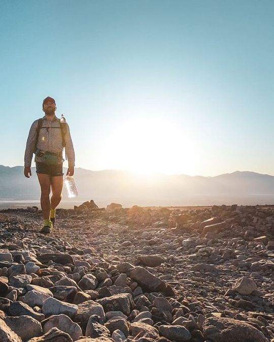
Lowest to Highest Day 2: I had a terrible night’s sleep last night; it turns out there are still plenty of insects active at night this low in the desert (I didn’t set up my shelter). . I begin the morning in the dark with already-warm temperatures. I’m not using trekking poles and so with my free hands I’ve decided to carry my water (instead of carrying it in my pack). I quickly discover that carrying a water bottle with an attached plastic handle is superior to carrying one with a paper handle attached via stickiness (I hope this description makes sense). The attached-plactic-handle bottle is also more structurally sound (this becomes important later in the day as I’m falling on my water bottle attempting to scramble up scree). . I follow a jeep road up Hanaupah Canyon until I find Hanaupah Spring. There’s a ton of water here and it’s more like a stream than a spring, but I’ll take it. There are signs warning that the water here might be contaminated from runoff from illegal cannabis grows in the area, but I’ve yet to hear from any hikers becoming sick from it. Regardless of the water’s status, I still have plenty of water from my first cache. Still, I fill up a gallon (this turns ou to be way too much) in a bottle just in case I need it. . From the spring the route cuts steeply up to a ridge as it climbs toward Telescope Peak. The climb is steep and I can’t find much in the way of use trails and so most of the climb involves trying to find the least-bad way up the mountain. Many hours of scrambling later, the sun is setting and I’ve yet to reach the top. I can still see where I began my hike last night which is a little sad, but eventually I make it to the ridge below Telescope Peak and collapse in the first sheltered campsite I find (it’s very windy). A full day hiking and just 16.72 mi / 26.91 km to show for it - this route is certainly a challenge (that said, there was 10,548 ft / 3,215 m of mostly off-trail elevation gain). . Day: West Side Road to ridge below Telescope Peak Day’s distance: 16.72 mi / 26.91 km Day’s elevation gain: 10,548 ft / 3,215 m . #LowToHighRoute #DeathValleyNationalPark
#deathvalley#l2h#hiking#californiadesert#natureza#lowtohighroute#l2hroute#backpacking#telescopepeak#halfwayanywhere#californiahiking#macincalifornia#socalhiking#extremewalking#mountains#badwaterbasin#lowesttohighest#deathvalleyhiking#hikertrash#hanaupahspring#lowesttohighestroute#deathvalleynp#deathvalleynationalpark#deserthiking#getoutside#desert#hanaupahcanyon#leavenotrace#lowtohigh
3 notes
·
View notes
Text
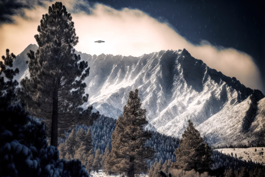
Be careful up in Mt. Baldy this weekend, with all the missing hikers and Chinese weather balloons and all.
#MtBaldy#AngelesCrest#UFOsighting#DangerousWeather#WeatherBalloon#Chineseweatherballoon#ChineseSpyBalloon#HikingMtBaldy#AngelesNationalForest#SocalHiking#SocalUFOs#Aiphotography
0 notes
Text


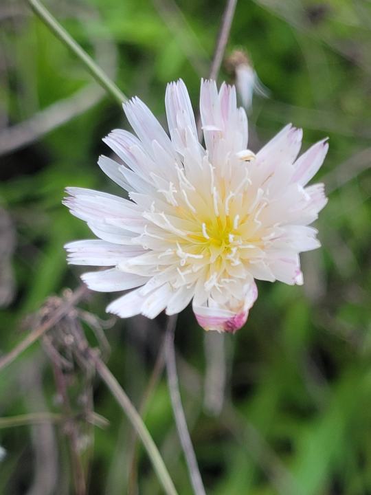
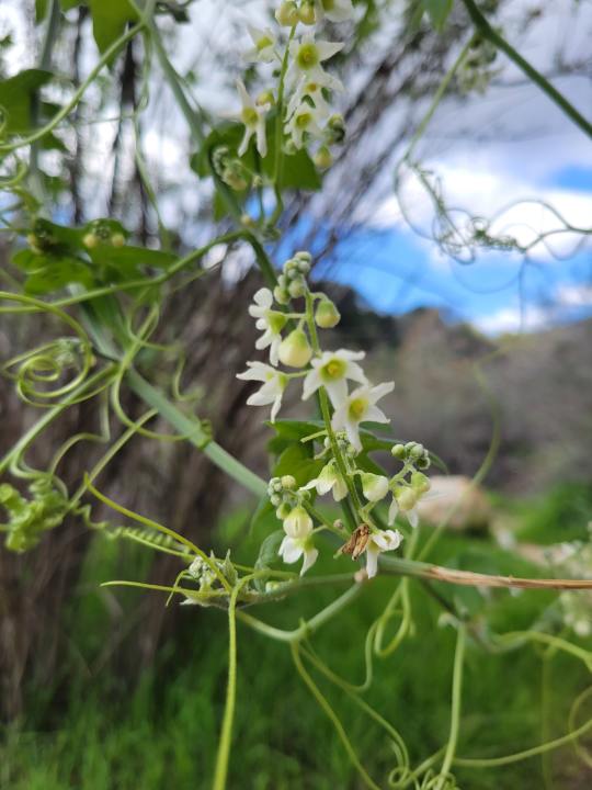

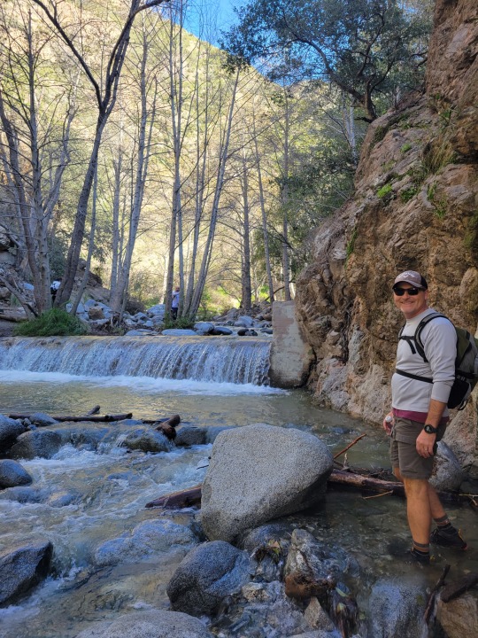

That one time we splished and splashed up Eaton Canyon to catch a booming waterfall after the crazy crazy Cali rains!
Super fun, gotta go with a feet wet mindset! That way you can jump and hope from rock to rock or just wade through, the water is high enough that you really couldn't make it to the falls without wet feet!
Some of the treasure we found along the way. I'll share my rock finds in a later post if I get around it. We are nature warriors and I'm hoping if I blog our adventures here it will help me remember what I found and what I learned!
The learns listed here:
Cliff Desert Dandelion aka Cliff Aster - Perennial Herb - Symbolizes Love - Only Found in Cali -Excellent in salads or brewed as tea. They are high in calcium and Vitamin A, with ample amounts of folic acid, Vitamin C and health-enhancing bioflavonoids.
Desert Starvine - Perennial Vine - It's part of the squash family is native to the deserts of California, Arizona, and northern Mexico. Grows small dry prickly fruits. No listed as poisonous but not enticing as a snack either.
Mule Fat - That doesn't even sound appealing. Evergreen shrub, native to SW states. Edible not but not really recommended. Found near water sources, dry creek beds etc.
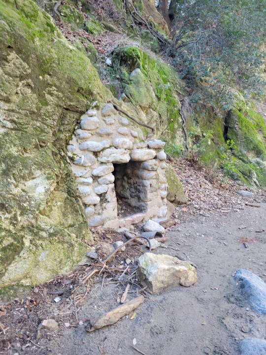
Yikes... I was gonna say bye and sign off, but realized I missed an opportunity to point out the little hobbit house we found! I mean, small brick entrance into the ground, what else could it possibly be?
Follow, thoughts, share or ignore! Much love to all!
0 notes
Photo

Happy Earth Day! · · · · · · #socalhikes #socalhike #socalhikers #hikesocal #socaladventures #caliadventures #caliadventures #adventurist #adventuristlife #escapism #escapist #melaninjourney #mytravelcrush #blacktraveljourney #travelisthenewclub #wegottoo #blackandabroad #blacktravelfeed #blacktravel #blacktravelgram #blacktraveljourney #blacktravelmovement #blacktravelclub #iloveutah #visitutah #beutahful #utahunique #igutah #utahhiking #adventurist (at Provo, Utah) https://www.instagram.com/jcjstreet/p/BwlJbf-FNgR/?utm_source=ig_tumblr_share&igshid=a0ck78csz3z9
#socalhikes#socalhike#socalhikers#hikesocal#socaladventures#caliadventures#adventurist#adventuristlife#escapism#escapist#melaninjourney#mytravelcrush#blacktraveljourney#travelisthenewclub#wegottoo#blackandabroad#blacktravelfeed#blacktravel#blacktravelgram#blacktravelmovement#blacktravelclub#iloveutah#visitutah#beutahful#utahunique#igutah#utahhiking
1 note
·
View note
Photo
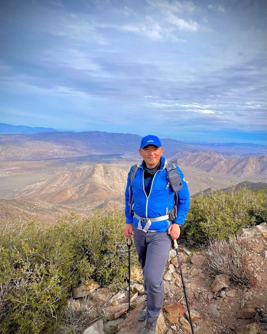
Laguna Mountain This is a gentle beautiful trail. Nice loop with desert views and peaceful meadows. This is one of the best hikes in So Cal. Highly recommended! Hike 50/52 for #52hikechallenge . . . . . #biglagunatrail #astrophotography #camping #cold #getoutside #glamping #hiking #mountain #mountlaguna #naturelover #optoutside #portraits #rsa #socal #socalhiker #trails #winterwonderland #cocktailhiker (at Big Laguna Trail) https://www.instagram.com/p/Cluuzg8LE3e/?igshid=NGJjMDIxMWI=
#52hikechallenge#biglagunatrail#astrophotography#camping#cold#getoutside#glamping#hiking#mountain#mountlaguna#naturelover#optoutside#portraits#rsa#socal#socalhiker#trails#winterwonderland#cocktailhiker
0 notes