#lowesttohighestroute
Explore tagged Tumblr posts
Photo

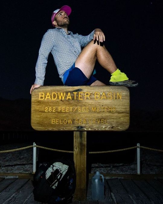
Lowest to Highest Route Day (Night) 1: I've been interested in the Lowest to Highest Route for a while now. It's a route that combines established trails, jeep roads, and off-trail navigation to link Badwater Basin (-278.9 ft / -85 m below sea level) to Mount Whitney (14,505 ft / 4,4𝟐𝟏 m above sea level) - the lowest place in the United States to the highest place in the (Continental) United States. Get it? Lowest to highest. After caching water for myself along the trail (because it turns out that Death Valley doesn't have many natural water sources), @paulinadao drops me off at Badwater Basin - well after dark. I would have preferred to begin hiking during the day, but I am grateful to have gotten a ride all the way out here into what's essentially the middle of nowhere. My hike this first night is short - just 6.91mi / 11.12 km - and takes me across the salt flats and to my first water cache. The days are short, so it will be an early morning tomorrow to head up what I have heard is a long and challenging climb up to the ridge below Telescope Peak. Hopefully, the water source at the end of this canyon is flowing tomorrow (the internets tell me it should be). Day: Badwater Basin to West Side Road Distance: 6.91mi / 11.12 km Elevation gain: 280 ft / 85 m #EXTREMEWALKING #badwater #badwaterbasin #l2h #deathvalley #deathvalleynationalpark #badwaterbasindeathvalley #deathvalleynp #belowsealevel #backpacking #hiking #hikertrash #trekking #deserthiking #california #nighthiking #deathvalleyhiking #ltohroute #outdoorlife #hikes #hiker #lowest2highest #adventuring #lowesttohighest #l2hroute #lowesttohighestroute #packitout #leavenotrace #halfwayanywhere #macincalifornia
#lowesttohighestroute#backpacking#badwaterbasindeathvalley#hikertrash#deathvalleyhiking#adventuring#l2h#outdoorlife#packitout#leavenotrace#hikes#halfwayanywhere#ltohroute#deathvalley#deserthiking#hiking#deathvalleynationalpark#badwaterbasin#lowesttohighest#nighthiking#hiker#extremewalking#lowest2highest#california#belowsealevel#l2hroute#deathvalleynp#trekking#badwater#macincalifornia
2 notes
·
View notes
Photo

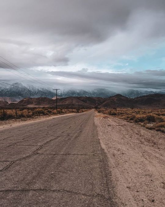
Lowest to Highest Day 6: I didn’t set up a shelter last night because my choice of campsite was much too steep and much too shit to allow for the undertaking of such a silly activity. My reward? Waking up at three in the morning to snow falling on top of me. Not the worst thing to wake up to, I suppose (it could be wolves) - but not the best either (breakfast and a clear way down the mountain would have been preferable). . It would seem that the weather promised to me when I began this trail nearly a week ago has come to fruition. I was hoping that it would end up being held up for a day somewhere, but it appears my luck has run out. The storm calls for over a foot of fresh snow at higher elevations and wind chill of down to -17°F/-27°C at elevations above 12,000 ft / 3,048 m (the summit of Mount Whitney is 14,505 ft / 4,421 m). . I pack up and begin my way down the mountainside hoping that my headlamp’s battery outlasts the rest of the night. . I’m not sure if I get off-route or if it’s the darkness, but this last downhill is some of the sketchiest bits of the hike thus far. Eventually I make it to flatter ground and eventually-er I make it to a jeep road. I follow the road out toward Highway 395 and my final water cache (which turns out to be unnecessary). As I walk the final hour toward the highway I stare at the now cloud and snow-covered Sierra Nevada Mountains in front of me. It’s not really much of a decision - I’m not going up Whitney (this storm is expected to last a few days). . I’ve already hiked the section of trail from Lone Pine to the Whitney summit, so I’m happy with what I’ve done. I would probably hike this route again if it meant connecting it to something larger in the Sierra. Next year, I suppose. . Day: Worst Campsite Ever to Lone Pine Day’s distance: 10.89 mi / 17.53 km Day’s elevation gain: 235 ft / 72 m #LowToHighRoute #LonePine
#lowesttohighestroute#lowesttohighest#nighthike#getoutside#lonepine#whitemountains#lowtohighroute#lonepineca#natureza#snow#sierranevedamountains#lowtohigh#l2h#hikertrash#leavenotrace#californiahiking#californiasierra#highway395#macincalifornia#l2hroute#deserthiking#socalhiking#backpacking#mountains#halfwayanywhere#sierraneveda#extremewalking#roadwalking#sierrahiking
1 note
·
View note
Photo

Lowest to Highest Day 3: Last night I got an enormous puncture in my sleeping pad; I did not have a great night of sleep. I have no puncture repair kit (didn’t think I would need it on this trip), but I do have a lot of duct tape. . I start hiking in the dark down the first defined trail that I’ve been for the entire route. Very exciting. Very exciting until the route calls for me to leave the trail and head down a featureless mountainside. Then, VERY exciting. My water froze last night and I have nearly all my layers on to keep myself from freezing in the cold morning air. It’s nice. . The way down isn’t too difficult to navigate and as I make it deeper into Tuber Canyon I find water at a couple of locations. In addition to water, I slowly start to find pieces of desert history - an old rusty can, a rusty pipe, a rusty car - exciting stuff. . I make it out into the valley and descend back down to near sea level. Much of the hiking today is flat (after the long downhill this morning), and when I make it to my second water cache I still have a lot to drink. Pouring out water in the desert feels wrong, but so does carrying it. . Panamint Springs is a small outpost in Death Valley with a gas station, general store, restaurant, and campground; it’s also where I’ve left a resupply for myself and where I hope to reach today. It’s after dark by the time I arrive. Fortunately, the gas station where I left my resupply is still open. Unfortunately, I still have a decent amount of food from when I began the hike and will now be carrying both too much food and too much water. Huzzah! The burger at the restaurant is as disappointing as the wifi. The wifi, I can live without, the burger is upsetting. . I continue a couple of miles past Panamint Springs and camp as soon as I finish up the road walk out. Tomorrow I’ll be taking an alternate route past Darwin Falls. A waterfall in the desert. Sounds magical. . Day: Ridge below Telescope Peak to Panamint Springs Day’s distance: 32.31 mi / 52 km Day’s elevation gain: 1,053 ft / 321 m #LowToHighRoute #DeathValleyNationalPark
#hanaupahcanyon#deathvalley#lowesttohighest#leavenotrace#deathvalleyhiking#getoutside#extremewalking#deserthiking#natureza#lowesttohighestroute#lowtohighroute#l2h#deathvalleynp#halfwayanywhere#lowtohigh#panamintsprings#deathvalleynationalpark#tubercanyon#hikertrash#badwaterbasin#telescopepeak#desert#californiadesert#backpacking#hanaupahspring#socalhiking#californiahiking#l2hroute#macincalifornia
0 notes