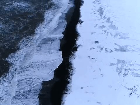
#northern Lake Huron shoreline
Explore tagged Tumblr posts
Visit Tumblr Blog
Explore Tumblr blogs with no restrictions, modern design and the best experience.
Last Seen Tumblr Blogs


Fun Fact
Tumblr’s reach among the 26-to-35-year-olds in the US is 11%.
Text


A moment of awe
Bald eagles have become a fairly common sight on our stretch of northern Lake Huron shoreline, but it's usually a fleeting glimpse and always from a distance; they never pose for photos.
This one lingered long enough Friday afternoon to let me run back inside to get my long lens. I got within a hundreds yards or so of the eagle's perch before it decided I was close enough. It rode its 6-foot wingspan our of sight.
It was my moment of awe for the day.
9 notes
·
View notes
Text
Below are 10 articles randomly chosen from Wikipedia's Featured Articles list. Brief descriptions and links are below the cut.
Bride of Frankenstein is a 1935 American science fiction horror film, and the first sequel to Universal Pictures' 1931 film Frankenstein. As with the first film, Bride of Frankenstein was directed by James Whale starring Boris Karloff as the Monster and Colin Clive as Dr. Frankenstein. The sequel features Elsa Lanchester in the dual role of Mary Shelley and the bride.
Chew Stoke is a small village and civil parish in the affluent Chew Valley, in Somerset, England, about 8 miles (13 km) south of Bristol and 10 miles north of Wells. It is at the northern edge of the Mendip Hills, a region designated by the United Kingdom as an Area of Outstanding Natural Beauty, and is within the Bristol and Bath green belt.
David Hillhouse Buel Jr. (July 19, 1862 – May 23, 1923) was an American priest who served as the president of Georgetown University. A Catholic priest and Jesuit for much of his life, he later left the Jesuit order to marry, and subsequently left the Catholic Church to become an Episcopal priest.
Denbies is a large estate to the northwest of Dorking in Surrey, England. A farmhouse and surrounding land originally owned by John Denby was purchased in 1734 by Jonathan Tyers, the proprietor of Vauxhall Gardens in London, and converted into a weekend retreat. The house he built appears to have been of little architectural significance, but the Gothic garden he developed in the grounds on the theme of death achieved some notoriety, despite being short-lived.
Courbet was the lead ship of her class of four dreadnought battleships, the first ones built for the French Navy. She was completed shortly before the start of World War I in August 1914.
The ketogenic diet is a high-fat, adequate-protein, low-carbohydrate dietary therapy that in conventional medicine is used mainly to treat hard-to-control (refractory) epilepsy in children. The diet forces the body to burn fats rather than carbohydrates.
The football match between Manchester United and Ipswich Town played at Old Trafford, Manchester, on 4 March 1995 as part of the 1994–95 FA Premier League finished in a 9–0 victory for the home team. The result stands as the joint record, with Southampton having subsequently lost by the same scoreline at home to Leicester City in 2019 and away at Manchester United in 2021, while Bournemouth also lost 9–0 to Liverpool in 2022.
M-185 is a state trunkline highway in the U.S. state of Michigan that circles Mackinac Island, a popular tourist destination on the Lake Huron side of the Straits of Mackinac, along the island's shoreline. A narrow paved road of 8.004 miles (12.881 km), it offers scenic views of the straits that divide the Upper and the Lower peninsulas of Michigan and Lakes Huron and Michigan.
Santa María de Óvila is a former Cistercian monastery built in Spain beginning in 1181 on the Tagus River near Trillo, Guadalajara, about 90 miles (140 km) northeast of Madrid. During prosperous times over the next four centuries, construction projects expanded and improved the small monastery. Its fortunes declined significantly in the 18th century, and in 1835 it was confiscated by the Spanish government and sold to private owners who used its buildings to shelter farm animals.
Sarcoscypha coccinea, commonly known as the scarlet elf cup, or the scarlet cup, is a species of fungus in the family Sarcoscyphaceae of the order Pezizales. The fungus, widely distributed in the Northern Hemisphere, has been found in Africa, Asia, Europe, North and South America, and Australia.
9 notes
·
View notes
Text
Lakes and Mistakes (Wattpad|Ao3)
A gift for @aloha-from-angel based on an older oneshot of hers.
━━━━━━━━ ✠ ━━━━━━━━
"Your trees are dead." Hawai'i said, stopping on the path and staring into the forest, "Come to think of it, It's all dead. Are you sure your plants are okay?"
I let out a little laugh, rolling my eyes at the question, "I know for a fact you know what fall is."
"That doesn't change the fact the trees are dead." She shrugged, then shivered in her winter jacket, wrapping it a little tighter around her, "And how cold it is right now, honestly I can't understand you or 'Laska or any of the northern states."
"I can't believe you," I grinned at her, "not having normal seasons."
"Wet and dry is all you need." She said with an edge of pretentiousness, walking quickly and passing me up on the trail, then laughed, "Except school time. Then seasons absolutely do matter, because then you need to know when the keiki get out."
"You really shouldn't be complaining about the weather this much, you're getting exactly what you wanted." I shook my head, still amused, "You were the one who asked me if there's any good surfing on the great lakes, and the best waves are at the end of the year."
"Hey I did a tiny bit of research, I just didn't think I'd be walking in a freezer for thirty minutes." she huffed indignantly, "But Mack-in-ack island seems pretty nice so far. Except for the fact those people back in town were staring at me." Hawai'i looked back at me blankly, "Why were they staring at me?"
I raised my eyebrows, surprised she even had to ask, "Have you taken a look at yourself? Anyone that bundled up at the beginning of September is gonna get some attention. Probably wondering why you're here. You look dressed for the arctic, and it's only 60 degrees out."
"57. I checked this morning." she said stubbornly, "it's not my fault I wasn't built for this climate." she thought an extra moment and a look of dawning disgust crossed her face.
"Oh no,"
"What's wrong?"
She looked back at me, seeming a little Ill, "I just realized I'm a tourist."
I couldn't help but break into an open laugh at that, "That's a bit hypocritical, after you've complained about tourism so much."
"Hey! I-" She paused again, thinking, then sighed in a melancholy way, looking down at her feet, "Thinking of it now- I really haven't done much traveling since the 1880's, so this is a bit... interesting."
"Getting nostalgic, are we?" I grinned, then switched to a frown, "But It's pronounced Mack-in-aw, not "Mack-in-ack. You said it wrong earlier, And before you look at me, it was the French and Brits that shortened a native name."
"Of course they did." Hawai'i rolled her eyes, "Ah France, my arch nemesis, how I long to strangle the crap out of you when we meet again."
"Drama queen."
"Perhaps." She sighed dramatically, "But back in my day..."
I cut her off, "How about we save it for later. I already know you're old, no need to bring attention to that." Then pointed through the trees, Lake Huron peeking through the orange and gold leaves, "We're here. Are you ready to try lake surfing?"
She snorted, amused, "I could surf before you were born. This will be a breeze."
━━━━━━━━ ✠ ━━━━━━━━
"You can turn back if it's too cold for you." I called to Hawai'i, who was frozen in place knee deep into the water. She looked stiffer than a dead fish in an ice chest.
"F**k off, Michigan." She glared over her shoulder, then waded a little deeper and grimaced,
"AUE, IT'S SO COLD."
She was clearly struggling, letting out gasps of shock whenever a wave hit her, I felt a little bad, Hawai'i with her wetsuit and surfboard seemed so out of place here. I made a mental note to watch her for signs of hypothermia, and set my bag down safely on shore after taking out the camera.
Walking over to the shoreline to test the temperature, I dipped my feet in to see if it was really as bad as she said.
While I am fully aware that Hawai'i was a tropical island and all- wow. She really was a drama queen. The water was surprisingly warm for this time of year, far better than it usually was.
I heard a loud splash and yelp of surprise from Hawai'i and looked up to see her fall straight into the water.
Her head bobbed to the surface and I couldn't control myself, cackling with laughter as I snagged a few photos of her. I could think of a few siblings who would appreciate having these.
"Are you..." She yelled, outraged, "I AM FREEZING MY ASS OFF AND YOU ARE LAUGHING."
"Too cold? I thought you could surf!" I shouted back at her, and snapped a few more photos, just for good measure.
"MICHIGAN I AM GOING TO BEAT YOUR ASS WHEN I GET THERE."
Another wave crashed over her and she went under, sputtering out curse words in languages I did and didn't recognize, sadly paddling back to shore in a shivering heap once she gained control of herself again.
"You're lucky I am nice to you and don't go back to burn all of your stuff right now." she sneezed and shivered some more, "If I get hypothermia or something and die, I'll kill you when I get back."
I smiled, passing her a large beach towel as she left the water, "Fun. Now I'm getting death threats."
"Your turn." she said, wringing out her hair, an edge of revenge in her voice.
Suddenly I felt a lot less sure of this, "I don't know if..."
"What, are you telling me now that you can't surf?" She smiled smugly, "C'mon, can you stand on a boat?"
"Of course, but-"
She nodded encouragingly, "It's exactly like that. Don't overthink it. As soon as you lose sight of what you're doing, you'll immediately wipe out."
It took a while, but I was eventually convinced to bite the bullet and try it out.
Which went about as well as you might expect.
"See! I told you the water was freezing!" she laughed after I resurfaced.
I shook the water out of my hair, and gave a pained smile, "I don't think I'm very good at this."
"Give it another try, just don't stress about it too much." She gave a light smile, "and hey, You know the lakes, I know the board. We can figure it out."
"Sure, Sandy-" I rolled my eyes, attempting a second time to balance on the surfboard, but was interrupted by Hawai'i pushing me off.
I hadn't expected the day to go like this, it was unusual, but fun. Better than I'd been hoping this would be. But if hanging out with Hawai'i meant doing things like this regularly-
Yeah- no, I'd just stick with my own region. At least they didn't complain about the weather this much.
2 notes
·
View notes
Photo
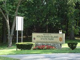


South Bass Island State Park
1523 Catawba Ave.
Put-In-Bay, OH 43456
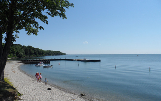
Balanced atop the white cliffs of South Bass Island, the park offers visitors a tranquil setting to enjoy nature and expansive views of Lake Erie. Located a few miles from one of Ohio's top tourist destinations-- Put-In-Bay-- visitors can enjoy camping, swimming, picnicking, and fishing. Overnight accommodations includes a campground, cabents, and camper cabin.
Prior to the late 1700s, the Lake Erie Island region had been occupied by Ottawa and Huron (Wyandot) Native American tribes. After the Revolutionary War, the land was granted to the former colonies and land development companies. However, the native Americans had not given up their own claims to these lands, resulting in ongoing conflicts with settlers. The British also remained in the area, harassing American ships, and encouraging the Indian resistance.
In 1807, John Pierpont Edwards of the Connecticut Land Company was granted ownership of the Bass islands. Edwards deeded the islands to his son, John Stark Edwards, settled on South Bass Island in 1811, and successfully cleared 100 acres and raised a crop of wheat within the first year. In June 1812, the U.S. declared war against Great Britain. Later that summer, the British recaptured their Revolutionary War stronghold, Fort Detroit, and ramped up the conflict. The Lake Erie Islands were evacuated.
A young naval officer, Oliver Hazard Perry, established a Lake Erie fleet to reassert American dominance on the lake. In September of 1813, Perry maneuvered his ships to the well protected cove at South Bass Island’s Put-In-Bay. Perry is reputed to have discovered Perry’s Cave as he prepared for the upcoming battle. Despite setbacks and his inferior fleet, Oliver Hazard Perry defeated the British commander Robert Barclay in a harrowing battle on September 10, 1813. Perry declared, "We have met the enemy and they are ours." The victory gave the Americans control of Lake Erie and led to the ultimate defeat of the British in the War of 1812.
John Stark Edwards died in 1813. His brother, Alfred, assumed control of the island and cut many of the island’s trees for timber in the 1830s and '40s. South Bass and the other islands remained sparsely settled until 1854, when Jose DeRivera purchased five of the islands. At first he turned Put-In-Bay into a sheep ranch with a herd of 2,000, but eventually he converted the island into a fruit farm. Despite the extreme northern location, the islands have the longest frost-free period in Ohio due to the stabilizing effect of the lake. By 1880, grapes and wine were the South Bass Island’s sole agricultural products, and became known as the "Wine Islands." Several island wineries still exist today.
Put-in-Bay became a tourist destination by the 1870s, and a number of small hotels were established near the bay. In 1889, promoter J.K. Tillotson began construction of a grand summer resort, the Hotel Victory, on the other side of the island near Stone’s Cove (the site of today’s state park). When it opened in June 1892, Victory Hotel was the largest hotel in the world. Unfortunately, it was destroyed by fire in 1919. The foundation of the swimming pool is all that remains. The former hotel land had remained mostly undeveloped when the state of Ohio purchased the property at Stone’s Cove in 1938, and constructed a new public dock. This property, along with Oak Point, was added to the state park system in 1951.
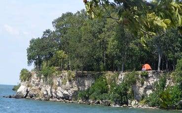
South Bass Island, in the western basin of Lake Erie, was formed during the glacial period when massive ice sheets from Canada advanced into Ohio. Glaciers gouged and scoured the bedrock, and their tremendous weight left deep depressions which filled with meltwater as the climate warmed and the glaciers retreated, forming the Great Lakes. Evidence of the glaciers can still be seen in the island’s bedrock, as small scratches in the rock surface known as glacial striations, and in deeper glacial grooves. A small set of glacial grooves is visible in exposed bedrock near the group camp at South Bass Island, while a large tract of impressive grooves is preserved on Kelleys Island.
Overall, Lake Erie is the shallowest of the Great Lakes, ranging from 25 feet deep in the western basin, to 61 feet deep in the central basin and an average depth of 120 feet in the eastern basin. As a result of its unequal, shallow basin, Lake Erie is known for its sudden, violent storms with high waves. Its warm temperatures produce greater numbers and varieties of fish than any other Great Lake, including walleye, yellow perch, smallmouth bass, white bass, and channel catfish. Annual catches nearly equal the combined catch of all other Great Lakes.
South Bass Island is dotted with collapsed caverns, which formed from the unique combination of the island’s layered dolomite bedrock, and the ever present lake water. Perry’s Cave is one of the few that has remained with its roof intact, and is one of the largest, at 200 feet long and 165 feet wide. The cave is more than 50 feet below the land surface. A rare underground lake deep within the cave rises and falls with the lake level.
The Lake Erie islands and shoreline provide precious habitat for the unique Lake Erie water snake. The eastern fox snake is common and harmless, but often mistaken for a rattlesnake because of its bold coloration and tendency to shake its tail when alarmed. The island is host to a variety of other reptiles and amphibians, including the red-eared slider, midland painted turtle, and common map turtle, and the mudpuppy and northern redback salamander.
Migrating songbirds and monarch butterflies rest here before winging across the lake. Hundreds of different bird species have been identified, making this one of the best birdwatching areas in the country. Dozens of species of migratory waterfowl also take refuge here. The bald eagle has made a dramatic comeback on Lake Erie, with several nesting pairs in the area.
The island’s shallow alkaline soils provide an ideal substrate for red cedar trees. Spring wildflowers include common species such as large-flowered trillium, bloodroot, trout lily, spring beauty, and Solomon’s seal, as well as the rare northern bog violet.
2 notes
·
View notes
Photo


Lake Michigan, Chicago (No. 2)
Some of the earliest human inhabitants of the Lake Michigan region were the Hopewell Indians. Their culture declined after 800 AD, and for the next few hundred years, the region was the home of peoples known as the Late Woodland Indians. In the early 17th century, when western European explorers made their first forays into the region, they encountered descendants of the Late Woodland Indians: the Chippewa; Menominee; Sauk; Fox; Winnebago; Miami; Ottawa; and Potawatomi. The French explorer Jean Nicolet is believed to have been the first European to reach Lake Michigan, possibly in 1634 or 1638. In the earliest European maps of the region, the name of Lake Illinois has been found in addition to that of "Michigan", named for the Illinois Confederation of tribes.
Lake Michigan is joined via the narrow, open-water Straits of Mackinac with Lake Huron, and the combined body of water is sometimes called Michigan–Huron (also Huron–Michigan). The Straits of Mackinac were an important Native American and fur trade route. Located on the southern side of the Straits is the town of Mackinaw City, Michigan, the site of Fort Michilimackinac, a reconstructed French fort founded in 1715, and on the northern side is St. Ignace, Michigan, site of a French Catholic mission to the Indians, founded in 1671. In 1673, Jacques Marquette, Louis Joliet and their crew of five Métis voyageurs followed Lake Michigan to Green Bay and up the Fox River, nearly to its headwaters, in their search for the Mississippi River, cf. Fox–Wisconsin Waterway. The eastern end of the Straits was controlled by Fort Mackinac on Mackinac Island, a British colonial and early American military base and fur trade center, founded in 1781.
With the advent of European exploration into the area in the late 17th century, Lake Michigan became part of a line of waterways leading from the Saint Lawrence River to the Mississippi River and thence to the Gulf of Mexico. French coureurs des bois and voyageurs established small ports and trading communities, such as Green Bay, on the lake during the late 17th and early 18th centuries.
In the 19th century, Lake Michigan played a major role in the development of Chicago and the Midwestern United States west of the lake. For example, 90% of the grain shipped from Chicago travelled east over Lake Michigan during the antebellum years, and only rarely falling below 50% after the Civil War and the major expansion of railroad shipping.
The first person to reach the deep bottom of Lake Michigan was J. Val Klump, a scientist at the University of Wisconsin–Milwaukee. Klump reached the bottom via submersible as part of a 1985 research expedition.
In 2007, a row of stones paralleling an ancient shoreline was discovered by Mark Holley, professor of underwater archeology at Northwestern Michigan College. This formation lies 40 feet (12 m) below the surface of the lake. One of the stones is said to have a carving resembling a mastodon. So far the formation has not been authenticated.
The warming of Lake Michigan was the subject of a report by Purdue University in 2018. In each decade since 1980, steady increases in obscure surface temperature have occurred. This is likely to lead to decreasing native habitat and to adversely affect native species survival.
Source: Wikipedia
#Lake Michigan#Lake Michigan Trail#Chicago Lakefront Trail#Chicago#USA#marina#water#nature#cityscape#original photography#summer 2019#Illinois#travel#vacation#skyline#Shedd Aquarium#architecture#night shot#reflection#evening light#landmark#tourist attraction#Great Lakes Region#Midwestern USA#Windy City#illuminated#Chitown
3 notes
·
View notes
Link

Excerpt:
The state of Michigan and Canadian pipeline company Enbridge announced a deal Wednesday to replace controversial aging pipelines that environmental groups worried put Lakes Michigan and Huron at risk for an oil spill, The Detroit Free Press reported.
Under the new plan, the existing 65-year-old pipelines, which are part of Enbridge's Line 5 carrying oil and liquefied natural gas between Wisconsin and Ontario, will be replaced with a new pipeline in a tunnel to be drilled into the bedrock beneath the Straits of Mackinac connecting Lakes Huron and Michigan, The Associated Press reported. The project will take seven to 10 years to complete and cost as much as $500 million. Enbridge will foot the bill.
Michigan Governor Rick Snyder called the proposal "a common-sense solution" to the problem posed by the aging pipelines, saying that it would resolve "nearly every risk" of an oil spill in the Straits of Mackinac.
But environmental groups, who have long opposed the pipeline, disagreed that the new plan was any sort of solution.
The Line 5 pipelines have been the subject of lawsuits and protests in recent months. The National Wildlife Federation and the Environmental Law & Policy Center sued the Coast Guard in August over an inadequate oil-spill response plan, in an ultimate bid to shut down the pipeline, since one is not allowed to operate a pipeline without a satisfactory response plan in place. Also in August, indigenous activists set up a protest camp in Northern Michigan to protest the pipelines.
A study in July found that an oil spill from the pipelines could damage 400 miles of Great Lakes shoreline and cost Michigan $2 billion.
#Enbridge#Enbridge Line 5#Great Lakes#Straits of Mackinac#Michigan#pipelines#oil pipelines#natural gas pipelines
3 notes
·
View notes
Photo


The winter weather hadn’t relented its clasp on Toronto, and white flurries of snow tumbled past the kitchen window and settled on the frigid ground below. A northern cardinal perched high in the boughs of the stunted white pine at the bottom of the home’s pathway. As the flakes continued to fall, the young bird’s feathers would grow a vivid, startling colour against the backdrop. A scarlet splatter on the fresh snow.
Lloyd breathed in deeply as his hands encircled the warm mug full of freshly-brewed black coffee. The kitchen was cool but it was significantly more welcoming than the world beyond, even with the cool tiles beneath his bare feet. As he took his first sip of the sharp liquid, he felt the heat slip down his throat. Yet, despite the comfortable warmth, it didn’t dislodge the chill that had wound itself around his spine.
Relentlessly the snowflakes fell, packing tighter and tighter atop one another. Inside Lloyd’s mind, he scrambled to claw at the thoughts that had riddled him the night before. The ocean crashed ceaselessly against his skull before plunging him into the depths. Dark. Cold. Alone. A bang from far away. His body being dragged endlessly down with a mouth open wide and screaming. Until something smothered it and dragged him backward into the black.
“I didn’t hear you get up.” Harley’s gentle voice broke through the crashing waves, and Lloyd lifted his head slowly to offer a polite smile. “Or feel you get up for that matter. I must have been tired. Cassie could never get out of bed without me waking up too.”
There was a terseness to her tone that made Lloyd instinctively grimace. Harley had always been an open book, but now it seemed like she’d turned her feelings into secrets and opted to keep them tightly to her chest. Sometimes, she felt like a copy of the woman he’d first met — with all the features and traits he knew and loved but different somehow.
In silence, Harley made a coffee of her own from the still scalding water sitting in the kettle, and Lloyd’s eyes slipped back to the world beyond the window. Sometimes he felt like a ghost. Sometimes he wondered whether he was stuck in limbo between living and the alternative. Sometimes the nights felt more real than the days.
“I’ve been thinking about what you said about coming back.” Harley’s voice almost made Lloyd jump, but the light hand on his back was a quick soother.
“I told you I don’t know why.”
“I know.” Last night was not the first time she’d pried into his justifications, and it wouldn’t be the last. “I know, Lloyd.”
Her nails pressed lightly into his shoulder blade. He lifted his head to look at her. The bags beneath her eyes were darker than he’d seen them in weeks. Her hair was flat against her neck. He missed the brightness of her smile. Like a flame in the darkness. A lighthouse in the ocean.
“I think you should call Jamie, Lloyd. You’ve been saying you will, but you haven’t.” Her voice was unusually hard. Imploring with an edge of demanding.
“I tried.”
“No, you didn’t. Not really.” Lifting a small hand, Harley wiped the underside of her nose and moved away to collect her steaming mug of coffee. “You can’t give me a reason why you came back, but did you even give her a reason why you left? Fuck, not even a reason. Did you even tell her at all?”
———— *** ————
The cold water slapped noisily against the ice floes drifting on the surface of the lake. The sandy beaches of Lake Huron were usually littered with tourists and locals alike in the summer months, but in the depths of winter, visitation was sparse apart from a committed few. The small figure atop a gnarled fallen log on the shoreline was neither a tourist, local nor committed.
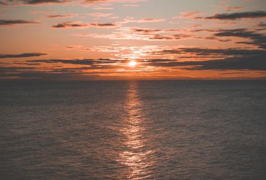
Jamie breathed in a lungful of cold air and released it in a pool of frozen fog. Her eyes, surprisingly bright, were fixed on a point far across the surface of the lake. The sky was a thick white but a soft red cut across it in veins. Another morning spent lost. Another morning spent alone.
Like the ice before her, Jamie’s mind was cast adrift. Splitting. Reforming. Tilting. She was equally atop an ice sheet scrambling for purchase but deep below causing the rise and fall of the water. Tipping herself deeper into the depths of her conscious.
Through a crack in the ice, a face appeared. Warm eyes. A steady smile. Frustrated words. Her own fault. A heavy blanket encasing her weary frame. The rich smell of Algonquin Park felt a million miles away. The thick safety of the trees and the sound of birds.
A crack split the quiet air. An ice sheet splintering apart, and Jamie recalled shaking hands clutching at pieces of glass. Squeezing so hard that it scored her skin. Flesh would heal but what about the marks left behind?
Without thinking, she wrenched a padded glove from her hand and stared at the skin. Her eyes darted across the creases. The cold bit at her fingers. Another crack split the silence as the ice fractured. Without thinking, Jamie threw her torso forward and screamed. The lake threw it back at her.
Stumbling to her feet, she snatched a piece of driftwood up from the sand.
“Stop it!” She shouted, hauling herself closer to the water’s edge. “Fucking stop it.”
“Stop what?” A voice answered back. Jamie turned sharply, lifting the branch high above her head. “It’s only you. It’s always only you.”
The fog engulfed her from far across the lake. A woman emerged from within it. Strikingly beautiful with vivid green eyes. She moved forward with confident steps until Jamie could have reached out and touched her. To pull her closer or to shove her away.
“I can’t do this,” Jamie whispered. The woman’s plump lips curved into a smile.
“Says who?”
The fog swirled and Jamie turned with it. The blade of a knife held high to strike. Reproachful eyes peering at her through the haze. Why would I take her in? Some whore’s child.
A warm car rocking her to the first relaxing sleep she’d had in months carrying her away from the cold. A timid creature wrenching itself wildly awake before hands dragged it back.
“Jamie?” Lloyd’s voice echoed around her. “Jamie. Please stop.”
Lloyd’s hand grabbed her arm, and Jamie tried to pull herself away.
“What can I do? How can I help?”
“You can’t!”
“I can’t lose you too.”
“You don’t even care.”
“Don’t be ridiculous, Jamie.”
The cold had hit her instantly as she’d slammed the door behind her, and she’d been running before Lloyd had even wrenched it open in her wake. His desperate footsteps reduced to nothing as she’d run.
Her eyes clenched shut and her chest heaved. Her knees hit the frost-spattered sand and soaked instantly into her trousers. From through the mist, a melodious tone rang. Her chin dropped to her chest, and ice blue eyes fixated on nothingness.
The ringing grew louder and, as if dragged from a stupor, she pawed at the pocket of her thick coat. Frozen fingers grasped her phone and wrenched it out. She lifted it to her ear.
“Jamie?”
“Lloyd.”
“Are you ok?”
“I don’t know.”
She pressed the heel of her hand hard to her forehead. She could hear the worry in his voice.
“You left me.” She whimpered. Suddenly, she was six years old again and chasing after the boys on their bikes until she tripped and fell. The skid of wheels had been instant as they both turned and rushed back to her.
“I know. I know I did.” His voice sounded as if it got stuck in his throat. “Where are you?”
“I don’t know.”
“Please, Jamie.”
“Lurgan Beach.”
“I’ll come and get you.”
“I don’t know what I’m doing.” And all at once, it hit her like an iceberg crashing into water. Heaving sobs split from her throat.
“Can you go somewhere warm? I’ll leave now.”
“I’m so sorry.”
“Jamie, can you listen to me, please?”
Tears spilled down her cheeks as she looked back across the lake. She was on an ice floe scrambling for something to steady her. Her fingers found a handhold.
Ducking down onto the sand, she recollected her glove and pushed it on.
“I’ll send you my location.”
A heavy breath rushed down the line. A woman’s voice spoke in hushed tones in the background followed by the sound of keys.
“I’ll see you soon, okay?”
“I hope so.”
1 note
·
View note
Text
What happens when Lake Superior has too much water? It dumps it into an already overflowing Lake Michigan
For nearly a century, a dam at the head of the St. Marys River near Sault Ste. Marie, Mich., has been used like a faucet, controlling the amount of water flowing from Lake Superior into lakes Michigan and Huron.
In the past five years, following a swift rise in lake levels, the relatively obscure Lake Superior board that regulates the amount of water released has stepped up these discharges, raising an outcry from a group representing property owners along the shoreline of Lake Michigan and potentially harming seasonal tourism.
John Ehret, an Olympia Fields, Ill., resident and a director of the Great Lakes Coalition for Shoreline Preservation, occasionally shows people photos of the broad sandy beaches that once existed outside his cabin in western Michigan. Now, Ehert said, many of his neighbors have fortified their home with boulders, and his property is “damn near in the water.”
Several factors have contributed to rising water levels and shoreline erosion, including increased precipitation and runoff, but Lake Superior outflow is exacerbating the problem, data from the National Ocean Atmospheric Administration and the International Lake Superior Board of Control show. Last year, the amount of water released from Lake Superior into lakes Michigan and Huron was the highest in 32 years.
This month, Lake Superior measured about 9 inches above its long-term average but almost 5 inches below its levels from last July. Lakes Michigan and Huron were recorded at nearly 2 feet above their historic average and a half inch higher than a year ago. Still, the Lake Superior board expects to increase the flow to 2,800 cubic meters per second this month — more than enough to fill an Olympic-size swimming pool each second — and above the amount called for in the most recent regulatory plan for balancing the lakes.
“They have no right ...,” Ehret, 88, said. “They are having the same problem we are. They've lost a lot of their sand. What they want is to lower their lake and dump it downstream — and we don't want it!”
U.S. officials say the elevated discharges aren’t simply an attempt to drive down Lake Superior’s levels, highlighting the need to accommodate hydropower plants, downstream fish-spawning habitat and commercial shipping.
The St. Marys River runs between Michigan's Upper Peninsula and Ontario, passing through a network of canals, hydropower plants and a dam with 16 steel control gates, which are regulated by the Lake Superior control board, a binational entity that determines how much water is released into the rapids. The board assumes the daunting responsibility of balancing the socio-economic and environmental interests of Lake Superior with those of lakes Michigan and Huron, which are considered one body of water because they are connected at the Straits of Mackinac.
Although Lake Superior’s flow has been fully regulated since 1921, scholars say it wasn’t until a period of high lake levels in the mid-1970s that the board adopted regulatory strategies that considered lakes Michigan and Huron.
John Allis, chief of Great Lakes hydraulics and hydrology for the Army Corps of Engineers, acknowledged the increased flow from Lake Superior can translate into a few inches of change in lakes Michigan and Huron but said the changes are insignificant.
“It’s very important to note that the deviations do not call for increasing flows only or decreasing flows only,” Allis said in an email. “We balance the flows over the year to balance total outflow and therefore have very minimal impact on water levels. One way to think of the deviations is as a method that serves to reduce adverse local effects while not affecting the Lakes overall.”
But according to Lake Superior board records, in the past five years, there has only been one month when Lake Superior flows were below the historical average.
Illinois state coastal geologist Ethan Theuerkauf said inches matter.
“You have to think about the slope,” Theuerkauf said. “If you’re talking a couple inches against a heavily armored bluff, you might not be impacting the shore that much. If lake levels are encroaching on a sandy shore and waves are moving farther up, a couple inches could have a profound impact.”
Dramatic swings in water levels
In January 2013, Lake Michigan hit a record low. Immediately afterward, it saw an unprecedented two-year rebound boosted by wetter-than-normal conditions and back-to-back polar vortex winters, which froze over much of the Great Lakes and prevented evaporation.
In the last century, Illinois has become 1.2 degrees warmer and 10 to 15 percent wetter, with much of the added water from heavy rainfalls or thunderstorms, according to state climatologist Jim Angel.
But scientists are divided over how climate change will affect the Great Lakes over the long term.
Rising lake levels
In 2015, amid the ongoing stretch of rising water levels in the Great Lakes, the control board implemented a modified regulatory plan that allows it to make small deviations to the amount of water released from Lake Superior without oversight.
Brig. Gen. Mark Toy, the U.S. chairman of the control board and Army Corps commander in the Great Lakes region, said the plan takes the entire region into consideration.
“Outflows from Lake Superior are currently set to help balance water level conditions and their related impacts to all stakeholders on Lake Superior, the St. Marys River, and Lake Michigan-Huron,” Toy said in an email.
Lake Superior discharges have been proven capable of shaving as much as 4.7 inches off lake levels in one month, which is greater than some of the highest rates of monthly evaporation, according to the International Joint Commission, the organization that oversees the control board and handles water disputes between Canada and the United States. For every inch Lake Superior can be lowered by water passed through the St. Marys River, lakes Michigan and Huron can rise a half inch, experts say.
Late last year, as Lake Superior swelled to nearly 4 inches shy of its record high set in 1985, the board ordered the highest discharges since it began adhering to the 2015 plan. Monthly outflows surged to more than 35 percent above historical averages for July, August, October and November. By April, aided by drier than usual conditions, Lake Superior had dropped more than one foot.
Now, with higher discharges expected to continue through November, some property owners on the lower lakes are watching the shoreline closely.
“The challenge is: How do you distribute the water between Lake Superior and Michigan,” said Roger Smithe, a spokesman for the Great Lakes Coalition for Shoreline Preservation, an organization that represents about 900 shoreline-property owners mostly from Michigan, Illinois, Wisconsin and Ohio. “Lately, we've seen articles about sharing the pain, but we think Lake Michigan shares most of the pain. We think Lake Michigan is a dumping ground for extra water.”
The Saugatuck, Mich.-based coalition has complained about a lack of public input and has written to the control board asking for an explanation about why more water continues to be released.
While control board representatives have stressed they have minimal control of Upper Great Lakes water levels, the consortium of Canadian and American decision-makers, which has historically been charged with keeping Lake Superior within predetermined high and low levels, has been known to open more dam gates if Lake Superior encroaches on those extremes.
Lakes Michigan and Huron have no such safety valve. The 6.3-foot range between their 1986 record highs and 2013 record lows is the largest of all the Great Lakes. By comparison, Lake Superior’s historic variability has been less than 4 feet.
Anxiety along Lake Superior
Despite help from the control board, the consequences of shoreline erosion are drastic along Lake Superior.
On the northern shores of Michigan’s Upper Peninsula, Tim and Susan Biehl have seen Lake Superior’s rising water overtake beaches, inundate sections of shoreline parks and in some cases claim entire homes.
“Cabins built 50, 60 years ago have gone into the lake,” said Tim Biehl, 71, who noted the water reaches to the tree line in some places. “You can walk down the north shore, and the number of trees on the beaches is phenomenal.”
After several years of anxiously watching the waters draw closer to their home, the Biehls and their neighbors joined a chorus of Yoopers calling for more discharges downstream.
“We’re just a bathtub to store water,” Tim Biehl said.
But that doesn’t sit well with Lake Superior’s southern neighbors who have their own complaints.
Every summer, for more than 30 years, Darcy Haury’s family has driven from suburban Chicago to stay at a vacation rental a few miles outside St. Joseph, Mich. Last year, she arrived at the cabin to find the beachfront where she had enjoyed building sand castles as a child was largely underwater. The stairs leading to the private shoreline had apparently been beaten into splintered timbers by a storm, and they were later told by management that the beach was closed.
Next month, relatives plan to return to the annual family tradition. But it could be the last time they go there.
“It's pretty depressing because it’s my favorite time of year,” said Haury, 28, of Bolingbrook. “Now we’re looking for somewhere else to go.”
Shrinking beaches
Along Illinois' 63-mile shoreline, there has been no shortage of issues.
In Evanston, though beaches have shrunk and the dog beach is completely submerged, the city has found that buying and importing sand to replenish beaches isn't a sound investment.
"That's not in our budget," said Lawrence Hemingway, Evanston's parks and recreation supervisor. "That's money that can wash away overnight"
Highland Park's Rosewood Beach, which was named among the nation's best restored beaches in 2016, was blitzed by powerful storms in April, which caused significant damage. In Chicago's Roger's Park neighborhood, Juneway Beach is all but submerged. And over the years, erosion has gnawed away at the shoreline walking trail at Illinois Beach State Park.
It's unclear if this has had an impact on tourism or recreation, but it certainly affects a visitor's experience, according to Diane Tecic, director of the Illinois Department of Natural Resources' coastal management program.
"Even with the high lake levels, I doubt people will just say, 'I'm just not going to go to the beach,'" Tecic said. "But it could shift where they go.”
Lake Michigan’s erosion issues have also been greatly complicated by development, which has cut off the natural flow of sand along much of the southern shores of Illinois, Indiana and Michigan. As a result, the sand washing from the shores isn’t being replenished.
At Illinois Beach State Park, state geologist Theuerkauf has extensively monitored the shoreline since 2014. In that time, he’s seen as much as 75 feet of shoreline chewed away in a year by Lake Michigan waves and storms.
Theuerkauf said this shoreline loss is unprecedented.
“Five hundred years ago this wetland would’ve been protected by a beach ridge further out.” said Theuerkauf, who has researched and dated the habitat. “Now, 500 years’ worth of shoreline is eroding in a matter of months.”
Under [these circumstances,] even though Lake Michigan’s lake levels are 1 ½ feet below the highs of 1986, the coastline continues to endure accelerated erosion as waves crash further inland.
“Sure, this has happened before,” Theuerkauf said about rising lake levels. “But now we’re permanently losing habitat, and things are always a little different the next time around. Because if the landscape changes, the outcome becomes different.”
Urgency versus history
Smithe, the Great Lakes coalition spokesman who lives in Manistee, Mich., said the alarming reality only requires a glance out the window for many of the group’s members.
In recent years, Smithe has thumbed through nearly 30-year-old documents from the International Joint Commission detailing several proposed solutions to handle high lake levels, which he said weren’t followed up on. Though he’d like to get more information on what can be done, he said the looming threat requires more immediate action.
“We don't need another study,” Smithe said. “We need action on one of the last studies.”
Drew Gronewold, hydrologist for NOAA’s Great Lakes Environmental Research Laboratory, said he can empathize with the sense of urgency that exists in the community during these high water levels. But he noted that a rush to judgment could easily put policymakers in a pinch down the road, cautioning people to remember the lakes’ history.
“Lake Michigan hit a record low in January 2013 and hit a record high in 1986 and a record low 1964. And there were discussions in what to do in those situations, which are [very] similar to those happening today. We should take time to look back at the resolutions for some insight for an appropriate pathway forward.”
For some, waiting and hoping the lake will subside is their only option.
Ehret, the coalition director with a lakefront cabin in Stevensville, Mich., typically splits his time between his home in Chicago’s south suburbs and his western Michigan hideaway. This year, he hasn’t gone to the cabin, and he’s not sure if he will.
“We usually go up there with our grandchildren,” Ehret said. “But with our house leaning into the lake, I don’t think they want to go. Last year, we had no beach.”
Lake Superior Board of Control’s annual public webinar/teleconference will be held 11 a.m. to noon central time on Thursday, July 19. The public can dial into the meeting at 1-877-413-4782, followed by this passcode: 3402087 or watch online here.
Click here for a video explaining how the Soo Locks work
(source: Chicago Tribune)
5 notes
·
View notes
Text
Canada Travel Guide and Advice for Tourists

Canada travel specialists can be instrumental in arranging a decent, critical trek. They have nearby information and encounter, and can concoct awesome visit proposition, from visa to aircraft tickets, from lodgings to visit aides and journeys.
Canada is a huge nation with a shocking assortment of vacation destinations. The Great Lakes of Ontario, Erie, and Huron are the colossal supply of new water and the place of amazing entertainment. The biggest area as per the quantity of tenants is Ontario, known for its vineyards, which create the lion’s offer of Canadian wines, and also the Big Horseshoe of Niagara Falls. Ontario alone has more than 30 national parks, wild uninhabited northern zones, around 50 thousand immaculate lakes and various waterways with an aggregate length of 55 thousand km. The capital of Canada Ottawa and also the city of Toronto are situated in this area.
Ottawa turned into the capital of Canada in 1857. The principle attractions of Ottawa are Parliament, the Tower of the World with more than fifty chimes on it, a beautiful quarter around the Market Hall Bayword, the Stables of the Royal Police, and Rideau Canal, which turns into the longest skating arena on the planet in winter months. A great deal of guests invest their energy in the Canadian Museum of Nature, the Museum of Science and Technology and other social settings. This is a tranquil, perfect and safe city.
Toronto is the biggest Canadian city and a main social and business focus of Canada. The city is regularly called the worldwide standard of neatness and request. This colossal city has an effectively conspicuous state of the considerable high rises, banks and workplaces, encompassed by many green parks, where squirrels and other little woodland creatures divert people in general. Toronto is the city of flawless patio nurseries and gardens confined by major thruways, and various national pieces neighboring with each other.
Quebec is the biggest and the most excellent territory in Canada. This region covers the most grand zones of the nation: the fields and the wonderful timberlands of the stream St. Lawrence, mines and lakes, Estrie and Charlevoix, Lake Saint-Jean, Madeleine Islands as the area of mariners and anglers. Here one fundamentally goes to the most seasoned urban areas in Canada, Quebec and Montreal. In Quebec, there are a few colleges, the well known waterfalls of Montmorency and the low northern slants of the Appalachian Mountains. Many delightful vacationer goals, ski resorts, sandy shorelines and ensured regions welcome the visitors. Scenes of southern Quebec are so differing and beguiling that it is frequently called ‘The Beautiful Province’.
Montreal is the biggest city in Quebec and one of the most established city in Canada. It is arranged on a stream island and is known for the pleasant roads. The city has the epithet of ‘the City of Saints’. Current Montreal is a city of high rises, expressways, tremendous worldwide transportation. It is an essential air and ocean passage of the nation, its noteworthy and social focus.
A standout amongst the most excellent areas in Canada is Nova Scotia, encompassed on three sides by the sea. The attractions incorporate wide shorelines and angling towns along the drift, the National Park in Cape Breton Island, the Vikokomag Indian Reservation, Annapolis, and numerous advantageous straights and shorelines.
Winnipeg is acclaimed for the Museum of Man and Nature, Winnipeg Art Gallery, The Building of the Confederation high rise, the celebrated Royal Winnipeg Ballet, and other verifiable and normal attractions.
English Columbia is the most western and sloping area of the nation. This is the zone of marine scenes, mountains, lakes, waterways, pine backwoods, green valleys with vineyards and plantations, the zone of stunning view and well disposed individuals.
Yukon is the zone’s incredible place for ‘dash for unheard of wealth’. Yukon’s wild spreads over the territory of 500 thousand square kilometers. The vast majority of the Yukon Territory is involved by the Cordillera, and in the far north there is the Arctic drift and tundra.
Airticketsbookings is well known travel agency that offers cheap flights tickets booking online. You can get cheap flights tickets at affordable price.
0 notes
Text

Lake keeps colors muted
We're back above the 45th Parallel, where most of Michigan is ablaze with color. Inland, the foliage is at its peak of splendor.
But , as you can see, it's a different story along the Lake Huron shoreline. The trees still are still smoldering, waiting for the frost that will, like a fresh breeze, fan the flame.
That's because lake holds heat, which delays the change
6 notes
·
View notes
Text
16 Amazing Facts About Lake Erie

It's one of the biggest and most popular lakes in North America, and in this post, you'll discover the ultimate list of facts about Lake Erie. Interesting facts about Lake Erie 1. It's located on the Canada-United States border Lake Erie is located right on the border between Canada and the United States. The northern shore is located in the Canadian province of Ontario, while the western, southern, and eastern shores are located in the U.S. states of Michigan, Ohio, Pennsylvania, and New York. There are a number of major cities located directly on its shoreline as well, including Buffalo in New York, Erie in Pennsylvania, and Cleveland and Toledo in Ohio. The lake with Cleveland, Ohio, in the background. / Source 2. It's one of the 5 Great lakes of North America The lake is one of the so-called "5 Great lakes of North America," which are all located on or near the Canadian-United States border. Apart from lake Erie, there's also Lake Superior, Lake Huron, Lake Ontario, and Lake Michigan. 3. It's the shallowest of the 5 Great Lakes Even though Lake Erie is the 4th-largest of the 5 Great Lakes by surface area, it's the smallest lake in terms of volume. That's because it's the shallowest of the 5 lakes with an average depth of just 62 feet (19 meters) and a maximum depth of 210 feet (64 meters). The lake has a maximum length of 241 miles (388 km), a maximum width of 57 miles (92 km), and a total surface area of 9,910 square miles (25,667 sq km). Read the full article
0 notes
Photo


Oak Point State Park
Bayview Ave.
Put-In-Bay, OH 43456
Located on South Bass Island, OH, Oak Point State Park is just 1.5 acres and close to Put-In-Bay. It offers amenities for boaters, anglers, and lake watchers. It's also just a short walk to Perry's Victory and International Peace Memorial. Restrooms and seasonal boat docks provide a respite for boaters, and a shelterhouse with lake views offers a place to picnic and relax. Prior to the late 1700s, the Lake Erie Island region had been occupied by Ottawa and Huron (Wyandot) Indian tribes. After the Revolutionary War, the land was granted to the former colonies, and land development companies. However, the native Americans had not given up their own claims to these lands, resulting in ongoing conflicts with settlers. The British also remained in the area, harassing American ships, and encouraging the Indian resistance.
In 1807, John Pierpont Edwards of the Connecticut Land Company, was granted ownership of the Bass islands. Edwards deeded the islands to his son, John Stark Edwards, settled on South Bass Island in 1811, and successfully cleared 100 acres and raised a crop of wheat within the first year. In June 1812, the U.S. declared war against Great Britain. Later that summer, the British recaptured their Revolutionary War stronghold, Fort Detroit, and ramped up the conflict. The Lake Erie Islands were evacuated. A young naval officer, Oliver Hazard Perry, established a Lake Erie fleet to reassert American dominance on the lake. In September of 1813, Perry maneuvered his ships to the well protected cove at South Bass Island’s Put-in-Bay. Perry is reputed to have discovered Perry’s Cave as he prepared for the upcoming battle. Despite setbacks and his inferior fleet, Oliver Hazard Perry defeated the British commander Robert Barclay in a harrowing battle on September 10, 1813. Perry declared, "We have met the enemy and they are ours." The victory gave the Americans control of Lake Erie and led to the ultimate defeat of the British in the War of 1812.
John Stark Edwards died in 1813. His brother, Alfred, assumed control of the island and cut many of the island’s trees for timber in the 1830s and 40s. South Bass and the other islands remained sparsely settled until 1854, when Jose DeRivera purchased five of the islands. At first he turned Put-In-Bay into a sheep ranch with a herd of 2,000, but eventually he converted the island into a fruit farm. Despite the extreme northern location, the islands have the longest frost-free period in Ohio due to the stabilizing effect of the lake. By 1880, grapes and wine were the South Bass Island’s sole agricultural products, and became known as the "Wine Islands." Several island wineries still exist today. Put-in-Bay became a tourist destination by the 1870s, and a number of small hotels were established near the bay. In 1889, promoter J.K. Tillotson began construction of a grand summer resort, the Hotel Victory, on the other side of the island near Stone’s Cove (the site of today’s South Bass Island State Park). When it opened in June 1892, Victory Hotel was the largest hotel in the world. Unfortunately, it was destroyed by fire in 1919. The foundation of the swimming pool is all that remains. The former hotel land had remained mostly undeveloped when the state of Ohio purchased the property at Stone’s Cove in 1938, and constructed a new public dock. Oak Point and South Bass Island state parks were added to the state park system in 1951.
South Bass Island, in the western basin of Lake Erie, was formed during the glacial period when massive ice sheets from Canada advanced into Ohio. Glaciers gouged and scoured the bedrock, and their tremendous weight left deep depressions which filled with meltwater as the climate warmed and the glaciers retreated, forming the Great Lakes. Evidence of the glaciers can still be seen in the island’s bedrock, as small scratches in the rock surface known as glacial striations, and in deeper glacial grooves. A small set of glacial grooves is visible in exposed bedrock near the group camp at South Bass Island, while a large tract of impressive grooves is preserved on Kelleys Island. Overall, Lake Erie is the shallowest of the Great Lakes, ranging from 25 feet deep in the western basin, to 61 feet deep in the central basin and an average depth of 120 feet in the eastern basin. As a result of its lopsided, shallow basin Lake Erie is known for its sudden, violent storms with high waves. Its warm temperatures produce greater numbers and varieties of fish than any other Great Lake, including walleye, yellow perch, smallmouth bass, white bass and channel catfish. Annual catches nearly equal the combined catch of all other Great Lakes.
South Bass Island is dotted with collapsed caverns, which formed from the unique combination of the island’s layered dolomite bedrock, and the ever present lake water. Perry’s Cave is one of the few that has remained with its roof intact, and one of the largest, at 200 feet long and 165 feet wide. The cave is more than 50 feet below the land surface. A rare underground lake deep within the cave rises and falls with the lake level. The Lake Erie islands and shoreline provide precious habitat for the unique Lake Erie water snake. The eastern fox snake is common and harmless, but often mistaken for a rattlesnake because of its bold coloration and tendency to shake its tail when alarmed. The island is host to a variety of other reptiles and amphibians, including the red-eared slider, midland painted turtle and common map turtle, and the mudpuppy and northern redback salamander.
Migrating songbirds rest here before winging across the lake. Hundreds of different species have been identified, making this one of the best birdwatching areas in the country. Dozen s of species of migratory waterfowl also take refuge here. The bald eagle has made a dramatic comeback on Lake Erie, with several nesting pairs in the area. The island’s shallow alkaline soils provide an ideal substrate for red cedar trees. Spring wildflowers include common species such as large-flowered trillium, bloodroot, trout lily, spring beauty and Solomon’s seal, as well as the rare northern bog violet.
0 notes
Photo


Fort York National Historic Site of Canada, Toronto (No. 25)
When Europeans first arrived at the site of York, the vicinity was inhabited by the Iroquoian Seneca tribe (from the Five Nations Iroquois of New York State), who by then had displaced the Wyandot (Huron) tribes that had occupied the region for centuries before c. 1600. By 1701, the Iroquoian villages that had been established along the north shore of Lake Ontario during the sixteenth century had been abandoned. The Algonkian Mississaugas then moved into the York region, created alliances with the former Iroquoian residents, and established their own settlements; one near the former Seneca village of Teiaiagon on the Humber River.
The name Toronto is derived from indigenous sources. A portage route from Lake Ontario to Lake Huron running through this point, the Toronto Carrying-Place Trail, led to widespread use of the name. The word "toronto", meaning "plenty" appears in a French lexicon of the Huron language in 1632, and it appeared on French maps referring to various locations, including Georgian Bay, Lake Simcoe, and several rivers. In Mohawk, the word tkaronto, meant "place where trees stand in the water".It refers to the northern end of what is now Lake Simcoe, where the Huron and preceding inhabitants had planted tree saplings to corral fish.
The shoreline was likely sandy and parts sloping down to Lake Ontario (see Geography of Toronto). The original shoreline followed what is now Front Street. Everything now south of Front Street is the result of land fill. The Toronto Islands were still connected to the mainland. It was wooded, with marshes in what is now Ashbridge's Bay and the then natural mouth of the Don (Keating Channel did not exist yet). Other than Lake Ontario, other waterways into old town included the Don and several other small creeks, such as Garrison Creek and Taddle Creek.
Between 1710 and 1750, French traders established two trading posts on the Humber River, Magasin Royale, and Fort Toronto. The success of Fort Toronto led the French to build Fort Rouillé on the current Exhibition grounds in 1750. It only lasted until 1759, abandoned after the fall of Fort Niagara, when the French retreated to Montreal. The British arrived the next year with an army to secure the location. The British claimed all of New France after the 1763 Treaty of Paris, and extended the Province of Quebec to present-day Ontario.
After the American Revolutionary War, the region saw an influx of British settlers as United Empire Loyalists arrived in numbers north of Lake Ontario, as the British offered free land to many. As plans were being made to create the new province of Upper Canada, British North America Governor-General Lord Dorchester selected the area north of Toronto Bay for a new capital. Dorchester arranged for the Toronto Purchase with the Mississaugas of New Credit, thereby securing more than a 250,000 acres (1,000 km2) of land. The purchase was disputed in 1788, and a further agreement was made in 1805, but a final settlement of the purchase would only come 200 years later in 2010, for a total of CA$145 million.
In 1791, Upper Canada was established, with Newark (Niagara-on-the-Lake) its first capital. The first Lieutenant-Governor John Graves Simcoe arrived in 1792 and first visited the Toronto Purchase site in May 1793. Impressed by the site and harbour, he moved the capital to Toronto, on a "temporary" basis, while he worked on plans to build a capital in the vicinity of London, Ontario. Simcoe renamed the townsite York, rejecting the aboriginal name. The name of York was chosen to please King George, as a compliment to the Duke of York, his son. Simcoe founded York on August 27, 1793.
Simcoe and his family took residence in July 1793. They found the location to be an isolated wilderness, with dense forest right to the shore. A few families of Mississauga were the only residents and "immense coveys of fowl." They lived in a tent that once belonged to Captain James Cook the explorer, at the foot of today's Bathurst Street. It would be the temporary capital until 1796, when Simcoe abandoned his plans to make London the capital. The first parliament of Upper Canada convened in June 1797 in York, after Simcoe had returned to England and Peter Russell was named administrator of Upper Canada.
The townsite was first surveyed in 1788, but Simcoe developed a new town plan. The Town of York was laid out in ten original blocks between today's Adelaide and Front streets (the latter following the shoreline) with the first church (St James Anglican), Town Hall and Wharf (named St Lawrence after the river) on the west and the first parliament buildings, blockhouse and windmill on the east. Taddle Creek lay on the eastern boundary, the Don River and its wetland further to the east. Two main roads were laid out: Dundas Street (today's Queen Street) and Yonge Street, which was built as far north as the Holland River. In 1797, a garrison was built east of modern-day Bathurst Street, on the east bank of Garrison Creek.
In August 1796, Charles McCuen, a soldier in the Queen's Rangers, murdered Wabakinine, a Mississauga chief and one of the signers of the Toronto Purchase, on the waterfront. The murder of Wabakinine and his wife threatened to derail the peace between the British and the Mississaugas. The Mississaugas, already frustrated by the failed promises of the Toronto Purchase, considered a counterattack, either on the capital itself or on nearby pioneer farms. The York authorities brought McCuen to trial for murder but he was ultimately acquitted due to lack of evidence. An uprising was averted through the efforts of Joseph Brant, a First Nations interpreter, guide and diplomat.
All land south of Dundas Street was reserved for expansion of the Town or Fort by the government as 'the Commons'. North of Dundas Street was the "Liberties", the eventual rural Township of York. It was divided into large 'park lots' where the city's moneyed elite built their estates, such as 'the Grange' and 'Moss park.' With time, some of these estate lots were subdivided, like the Macaulay family estate between Yonge St and Osgoode Hall (now Toronto City Hall), which became a working-class neighbourhood known as Macaulaytown. The original townsite area is today known as the "Old Town".
Source: Wikipedia
#Fort York National Historic Site#Fort York National Historic Site of Canada#travel#Fort York Heritage Conservation District#Old Fort York#Garrison#Toronto#Ontario#Canada#summer 2018#original photography#vacation#museum#cityscape#architecture#exterior#interior#landmark#tourist attraction#Stone Magazine#WMG 1815#inscription#shaft#detail
3 notes
·
View notes
Text
Michigan’s 15 Points of Interest
Michigan is a beautiful state—which is why we here at Livnfresh are always inspired to make high-quality state pride apparel. We know all about the sights and the sounds of the Mitten State. But for those who are not yet familiar with the wonders of Michigan—you are in luck! We are here to talk about some of the best destinations in the state.
Michigan has a lot of awesome places for you to explore and discover. Here we are listing down the top 15 points of interest in Michigan. This includes cities, villages, and other destinations that will make you fall in love with the state. For the cities, we are also listing down a few suggested spots for you to visit with your friends and family.
Detroit
As the largest city in the Midwestern state of Michigan, Detroit has plenty of activities for you and your loved ones to get into. Near Downtown, the neoclassical Detroit Institute of Arts is known for the Detroit Industry Murals painted by Diego Rivera. It is inspired by the city’s ties to the auto industry, which gives it the nickname Motor City.
Downtown attractions include Comerica Park, Fox Theatre, the Henry Ford Museum, and Belle Isle.
Detroit is also the birthplace of Motown Records, whose chart-topping history is on display at Hitsville USA, which is their original headquarters.
After exploring this big city, you might want to grab a bite in the nearby neighborhood of Greektown, which has a few Greek restaurants.
Traverse City
Known for its annual National Cherry Festival, Traverse City is another popular destination. It is located on the shores of Lake Michigan’s Grand Traverse Bay and features a few breath-taking beaches such as Clinch Park, West End Beach, and East Bay Park.
For those who are interested in watching plays and concerts, the Victorian City Opera House is a perfect choice. Meanwhile, the Dennos Museum Center has an Inuit art collection and features works by Michigan artists.
Traverse City is rich in both cultural and natural attractions.
Mackinac Island
If you want to get away from the cities and hop on to an island adventure, then Michigan’s very own Mackinac Island is the right choice for you. Mackinac Island sits in Lake Huron, between Michigan’s Upper and Lower peninsulas. The island’s State Park has trails, woods, and limestone Arch Rock formations that cover most of the land. Fort Mackinac is a walled cluster of military buildings on a coastal bluff, founded way back in 1780.
Mackinac Island also holds the Richard and Jane Manoogian Mackinac Art Museum that features local works such as Native American art, maps, and photos from the 19th century. This island is rich in history, and you might be surprised by what you learn.
You can also visit the Original Mackinac Island Butterfly House and Insect World to view tropical gardens and live butterflies.
Sleeping Bear Dunes National Lakeshore
The Sleeping Bear Dunes National Lakeshore is a national park in Michigan that features sand dunes, lakes, trails, and many campsites. This sprawling nature preserve is as old as continental ice sheets and as young as the 1970 Establishment Act that set aside the Lakeshore for the preservation of natural resources.
The immense sand dunes perched above Lake Michigan are its most prominent features. These dunes sit atop the already towering headlands that are glacial moraines. It’s a magnificent sight that overlooks the Sleeping Bear, Empire, and Pyramid Point bluffs from above 400 feet.
Pictured Rocks National Lakeshore
Another national lakeshore, this park offers 40 miles of lakeshore and 100 miles of trails winding through a northern hardwood forest. It is unlike any place on Lake Superior because the Pictured Rocks offers miles of pristine beaches and incredible hiking trails. Visitors can even view towering sandstone cliffs and experience the serenity of northern woodlands.
In the spring, Pictured Rocks National Lakeshore transforms into a sea of beautiful wildflowers. Summer gives way to warm basking days. This destination highlights the best of Michigan weather and why we love it so much.
Grand Rapids
Grand Rapids is a Michigan city on the Grand River, east of Lake Michigan. Favorite tourist spots include the Gerald R. Ford Presidential Museum which celebrates the life and legacy of the 38th US president; the Meyer May House; the John Ball Zoo; and the Millennium Park.
On the outskirts of Grand Rapids sits the Frederik Meijer Gardens and Sculpture Park that has a tropical conservatory and multiple gardens.
Ann Arbor
Another Michigan city, Ann Arbor is located west of Detroit and is home to the sprawling University of Michigan, which is known for its research programs.
The University of Michigan Museum of Art displays works from around the globe spanning centuries. If you are looking for science-focused attractions in the city, the Museum of Natural History and the Ann Arbor Hands-On Museum offer great exhibits that are suitable for adults and kids alike.
Ann Arbor also has the Kelsey Museum of Archaeology, which features permanent exhibits including Roman sculptures and an Egyptian mummy coffin.
Holland
This Michigan city is located on the shore of Lake Macatawa. It is well-known for the Big Red Lighthouse that stands by the channel that connects the lake to Lake Michigan. Nearby is the beachfront Holland State Park that shelters deer and migratory birds.
Holland also celebrates Tulip Time Festival every May and sees tulips blooming all over the city.
youtube
Isle Royale National Park
This isle in Michigan is designated as wilderness. This archipelago offers hiking, kayaking, and scuba diving activities in Lake Superior.
Here you can explore a rugged, isolated island that is far from the sights and sounds of modern civilization. Isle Royale is unparalleled when it comes to beauty and solitude. Do keep in mind that the island is closed from November 1 through April 15 annually.
Petoskey
Petoskey is a city and coastal resort community with a population of approximately 5,670. It is the county seat of Emmet County and has destinations such as the Crooked Tree Arts Center, Bear River Valley Recreation Area, Petoskey State Park, Odawa Casino, and the Great Lakes Center for the Arts.
It’s a nice small city with a lot of variety when it comes to activities, so it is definitely a nice place to visit.
Marquette
Marquette is a city in Michigan as well as the county seat of Marquette County. It is the largest city of the state’s Upper Peninsula. It is a major port on Lake Superior, known primarily for shipping iron ore. It is also the home of Northern Michigan University.
Popular attractions include the Presque Isle Park, Sugarloaf Mountain, Marquette Mountain Ski & Bike Area, and the Marquette Harbor Lighthouse.
This city was even listed by CBS as one of the 10 best places to retire in the US back in 2012.
Munising
Another Michigan city, Munising is found on the southern shore of Lake Superior on the Upper Peninsula of Michigan. It is the county seat of Alger County and is partially surrounded by Munising Township. However, both are administered autonomously.
In this city, you will find the lovely Munising Falls. Also popular among tourists are the Pictured Rocks Cruises, Glass Bottom Shipwreck Tours, and Wagner Falls.
Mackinaw City
This Michigan village is located on the northern tip of the state’s Lower Peninsula. Mackinac Bridge crosses the Straits of Mackinac to the Upper Peninsula.
Founded in 1889, Old Mackinac Point Lighthouse has restored quarters and views from the top. Wilderness State Park includes stretches of Lake Michigan shoreline, trails, and campsites. Other popular attractions include the Fort Michilimackinac, the McGulpin Point Lighthouse, and the Ice Breaker Mackinaw Maritime.
Lansing
Lansing is the capital city of our beloved Michigan. Dating to the 1870s, the Michigan State Capitol building features a cast-iron dome. Also in Lansing is The Impression 5 Science Center, which has interactive displays.
Another good destination for those interested in science and nature is The Potter Park Zoo. It houses endangered and threatened species such as Magellanic penguins, black rhinos and golden lion tamarins.
Frankenmuth
Last but not least, this point of interest is another Michigan city that has a wide array of tourist attractions. Frankenmuth is known for its Bavarian-style architecture. It is also rich in culture and history.
The Frankenmuth Historical Museum highlights the area’s German roots. Michigan’s Military & Space Heroes Museum features different kinds of flight gear, Medals of Honor and military equipment.
If you’re looking for an adventure, Frankenmuth Aerial Park offers ropes courses and zip lines in a wooded area. Other great choices include The Michigan Heroes Museum and St Lorenz Lutheran Church.
There are many reasons to visit Michigan, and here we’ve compiled just a few of the most popular ones. Visit Livnfresh.com and show off your state pride today!
best michigan clothing company
from Livnfresh Blog|The Coolest State Apparel Co. https://blog.livnfresh.com/points-of-interest-in-michigan/ from Livnfresh Share Your State Pride. https://livnfresh.tumblr.com/post/189967967282 via https://livnfresh.tumblr.com/
0 notes
Text
Michigan’s 15 Points of Interest
Michigan is a beautiful state—which is why we here at Livnfresh are always inspired to make high-quality state pride apparel. We know all about the sights and the sounds of the Mitten State. But for those who are not yet familiar with the wonders of Michigan—you are in luck! We are here to talk about some of the best destinations in the state.
Michigan has a lot of awesome places for you to explore and discover. Here we are listing down the top 15 points of interest in Michigan. This includes cities, villages, and other destinations that will make you fall in love with the state. For the cities, we are also listing down a few suggested spots for you to visit with your friends and family.
Detroit
As the largest city in the Midwestern state of Michigan, Detroit has plenty of activities for you and your loved ones to get into. Near Downtown, the neoclassical Detroit Institute of Arts is known for the Detroit Industry Murals painted by Diego Rivera. It is inspired by the city’s ties to the auto industry, which gives it the nickname Motor City.
Downtown attractions include Comerica Park, Fox Theatre, the Henry Ford Museum, and Belle Isle.
Detroit is also the birthplace of Motown Records, whose chart-topping history is on display at Hitsville USA, which is their original headquarters.
After exploring this big city, you might want to grab a bite in the nearby neighborhood of Greektown, which has a few Greek restaurants.
Traverse City
Known for its annual National Cherry Festival, Traverse City is another popular destination. It is located on the shores of Lake Michigan’s Grand Traverse Bay and features a few breath-taking beaches such as Clinch Park, West End Beach, and East Bay Park.
For those who are interested in watching plays and concerts, the Victorian City Opera House is a perfect choice. Meanwhile, the Dennos Museum Center has an Inuit art collection and features works by Michigan artists.
Traverse City is rich in both cultural and natural attractions.

Mackinac Island
If you want to get away from the cities and hop on to an island adventure, then Michigan’s very own Mackinac Island is the right choice for you. Mackinac Island sits in Lake Huron, between Michigan’s Upper and Lower peninsulas. The island’s State Park has trails, woods, and limestone Arch Rock formations that cover most of the land. Fort Mackinac is a walled cluster of military buildings on a coastal bluff, founded way back in 1780.
Mackinac Island also holds the Richard and Jane Manoogian Mackinac Art Museum that features local works such as Native American art, maps, and photos from the 19th century. This island is rich in history, and you might be surprised by what you learn.
You can also visit the Original Mackinac Island Butterfly House and Insect World to view tropical gardens and live butterflies.
Sleeping Bear Dunes National Lakeshore
The Sleeping Bear Dunes National Lakeshore is a national park in Michigan that features sand dunes, lakes, trails, and many campsites. This sprawling nature preserve is as old as continental ice sheets and as young as the 1970 Establishment Act that set aside the Lakeshore for the preservation of natural resources.
The immense sand dunes perched above Lake Michigan are its most prominent features. These dunes sit atop the already towering headlands that are glacial moraines. It’s a magnificent sight that overlooks the Sleeping Bear, Empire, and Pyramid Point bluffs from above 400 feet.
Pictured Rocks National Lakeshore
Another national lakeshore, this park offers 40 miles of lakeshore and 100 miles of trails winding through a northern hardwood forest. It is unlike any place on Lake Superior because the Pictured Rocks offers miles of pristine beaches and incredible hiking trails. Visitors can even view towering sandstone cliffs and experience the serenity of northern woodlands.
In the spring, Pictured Rocks National Lakeshore transforms into a sea of beautiful wildflowers. Summer gives way to warm basking days. This destination highlights the best of Michigan weather and why we love it so much.
Grand Rapids
Grand Rapids is a Michigan city on the Grand River, east of Lake Michigan. Favorite tourist spots include the Gerald R. Ford Presidential Museum which celebrates the life and legacy of the 38th US president; the Meyer May House; the John Ball Zoo; and the Millennium Park.
On the outskirts of Grand Rapids sits the Frederik Meijer Gardens and Sculpture Park that has a tropical conservatory and multiple gardens.
Ann Arbor
Another Michigan city, Ann Arbor is located west of Detroit and is home to the sprawling University of Michigan, which is known for its research programs.
The University of Michigan Museum of Art displays works from around the globe spanning centuries. If you are looking for science-focused attractions in the city, the Museum of Natural History and the Ann Arbor Hands-On Museum offer great exhibits that are suitable for adults and kids alike.
Ann Arbor also has the Kelsey Museum of Archaeology, which features permanent exhibits including Roman sculptures and an Egyptian mummy coffin.
Holland
This Michigan city is located on the shore of Lake Macatawa. It is well-known for the Big Red Lighthouse that stands by the channel that connects the lake to Lake Michigan. Nearby is the beachfront Holland State Park that shelters deer and migratory birds.
Holland also celebrates Tulip Time Festival every May and sees tulips blooming all over the city.
youtube
Isle Royale National Park
This isle in Michigan is designated as wilderness. This archipelago offers hiking, kayaking, and scuba diving activities in Lake Superior.
Here you can explore a rugged, isolated island that is far from the sights and sounds of modern civilization. Isle Royale is unparalleled when it comes to beauty and solitude. Do keep in mind that the island is closed from November 1 through April 15 annually.
Petoskey
Petoskey is a city and coastal resort community with a population of approximately 5,670. It is the county seat of Emmet County and has destinations such as the Crooked Tree Arts Center, Bear River Valley Recreation Area, Petoskey State Park, Odawa Casino, and the Great Lakes Center for the Arts.
It’s a nice small city with a lot of variety when it comes to activities, so it is definitely a nice place to visit.
Marquette
Marquette is a city in Michigan as well as the county seat of Marquette County. It is the largest city of the state’s Upper Peninsula. It is a major port on Lake Superior, known primarily for shipping iron ore. It is also the home of Northern Michigan University.
Popular attractions include the Presque Isle Park, Sugarloaf Mountain, Marquette Mountain Ski & Bike Area, and the Marquette Harbor Lighthouse.
This city was even listed by CBS as one of the 10 best places to retire in the US back in 2012.
Munising
Another Michigan city, Munising is found on the southern shore of Lake Superior on the Upper Peninsula of Michigan. It is the county seat of Alger County and is partially surrounded by Munising Township. However, both are administered autonomously.
In this city, you will find the lovely Munising Falls. Also popular among tourists are the Pictured Rocks Cruises, Glass Bottom Shipwreck Tours, and Wagner Falls.
Mackinaw City
This Michigan village is located on the northern tip of the state’s Lower Peninsula. Mackinac Bridge crosses the Straits of Mackinac to the Upper Peninsula.
Founded in 1889, Old Mackinac Point Lighthouse has restored quarters and views from the top. Wilderness State Park includes stretches of Lake Michigan shoreline, trails, and campsites. Other popular attractions include the Fort Michilimackinac, the McGulpin Point Lighthouse, and the Ice Breaker Mackinaw Maritime.
Lansing
Lansing is the capital city of our beloved Michigan. Dating to the 1870s, the Michigan State Capitol building features a cast-iron dome. Also in Lansing is The Impression 5 Science Center, which has interactive displays.
Another good destination for those interested in science and nature is The Potter Park Zoo. It houses endangered and threatened species such as Magellanic penguins, black rhinos and golden lion tamarins.
Frankenmuth
Last but not least, this point of interest is another Michigan city that has a wide array of tourist attractions. Frankenmuth is known for its Bavarian-style architecture. It is also rich in culture and history.
The Frankenmuth Historical Museum highlights the area’s German roots. Michigan’s Military & Space Heroes Museum features different kinds of flight gear, Medals of Honor and military equipment.
If you’re looking for an adventure, Frankenmuth Aerial Park offers ropes courses and zip lines in a wooded area. Other great choices include The Michigan Heroes Museum and St Lorenz Lutheran Church.
There are many reasons to visit Michigan, and here we’ve compiled just a few of the most popular ones. Visit Livnfresh.com and show off your state pride today!
best michigan clothing company
from Michigan | Livnfresh Blog|The Coolest State Apparel Co. https://blog.livnfresh.com/points-of-interest-in-michigan/
0 notes
Text
The Big Blow of 1913

Type Cyclonic blizzard, extratropical cyclone
Formed November 6, 1913
Dissipated November 11, 1913
Lowest pressure 968.5 mb (28.60 inches)
The Great Lakes Storm of 1913, historically referred to as the "Big Blow," "Freshwater Fury," or the "White Hurricane," was a blizzard with hurricane-force winds that devastated the Great Lakes Basin from November 7 through November 10, 1913.
The storm was most powerful on November 9, battering and overturning ships on four of the five Great Lakes, particularly Lake Huron. Deceptive lulls in the storm and the slow pace of weather reports contributed to the storm's destructiveness.

The storm killed more than 250 people, destroyed 19 ships, and stranded 19 others.
The storm originated as the convergence of two major storm fronts, fueled by the lakes' relatively warm waters—a seasonal process called a "November gale". It produced 90 mph (145 km/h) wind gusts, waves over 35 feet (11 m) high, and whiteout snowsqualls.
Such a storm can maintain hurricane-force wind gusts, produce waves over 50 feet (15 m) high, and dump several inches of rain or feet of snow. Fuelled by the warm lake water, these powerful storms may remain over the Great Lakes for days. Intense winds ravage the lakes and surrounding shores, severely eroding and flooding the shorelines.
November gales have been a bane of the Great Lakes, with at least 25 killer storms striking the region since 1847. During the Big Blow of 1905, 27 wooden vessels were lost. During a November gale in 1975, the giant ore bulk carrier SS Edmund Fitzgerald sank suddenly with all hands, without a distress signal.
Prelude to the storm
The storm was first noticed on Thursday, November 6, on the western side of Lake Superior, moving rapidly toward northern Lake Michigan. The weather forecast in The Detroit News called for "moderate to brisk" winds for the Great Lakes, with occasional rains Thursday night or Friday for the upper lakes (except on southern Lake Huron), and fair to unsettled conditions for the lower lakes.
Around midnight, the steamer Cornell, while 50 miles (80 km) west of Whitefish Point in Lake Superior, ran into a sudden northerly gale and was badly damaged. This gale lasted until late November 10, almost forcing Cornell ashore.

On Friday, the weather forecast in the Port Huron Times-Herald of Port Huron, Michigan, described the storm as "moderately severe." By then, the storm was centered over the upper Mississippi Valley and had caused moderate to brisk southerly winds with warmer weather over the lakes. The forecast predicted increased winds and falling temperatures over the next 24 hours.

At 10:00 a.m., Coast Guard stations and United States Department of Agriculture (USDA) Weather Bureau offices at Lake Superior ports raised white pennants above square red flags with black centers, indicating a storm warning with northwesterly winds. By late afternoon, the storm signal flags were replaced with a vertical sequence of red, white, and red lanterns, indicating that a hurricane with winds over 74 mph (119 km/h) was coming. (The word hurricane here does not refer to a tropical cyclone, but to Force 12 winds on the Beaufort scale.) The winds on Lake Superior had already reached 50 mph (80 km/h), and an accompanying blizzard was moving toward Lake Huron.

By Saturday, the storm's status had been upgraded to "severe". The storm was centered over eastern Lake Superior, covering the entire lake basin. The weather forecast of the Port Huron Times-Herald stated that southerly winds had remained "moderate to brisk". Northwesterly winds had reached gale strength on northern Lake Michigan and western Lake Superior, with winds of up to 60 mph (97 km/h) at Duluth, Minnesota.
A false lull in the storm (a "sucker hole") allowed traffic to begin flowing again, both down the St. Marys River and up Lake Erie, and the Detroit and St. Clair rivers, into Lake Huron. Gale wind flags were raised at more than a hundred ports, but were ignored by many ship captains. Long ships traveled all that day through the St. Marys River, all night through the Straits of Mackinac, and early Sunday morning up the Detroit and St. Clair rivers. By noon on Sunday, weather conditions on lower Lake Huron were close to normal for a November gale. Barometric pressures in some areas began to rise, bringing hope of an end to the storm. The low pressure area that had moved across Lake Superior was moving northeast, away from the lakes.
Along southeastern Lake Erie, near the city of Erie, Pennsylvania, a southern low-pressure area was moving toward the lake. This low had formed overnight, so was absent from Friday's weather map. It had been traveling northward and began moving northwestward after passing over Washington, D.C.
The intense counterclockwise rotation of the low was made apparent by the changing wind directions around its center. In Buffalo, New York, morning northwest winds had shifted to northeast by noon and were blowing southeast by 5:00 p.m., with the fastest gusts, 80 mph (130 km/h), occurring between 1:00 p.m. and 2:00 p.m. Just 180 miles (290 km) to the southwest, in Cleveland, winds remained northwest during the day, shifting to the west by 5:00 p.m., and maintaining speeds of more than 50 mph (80 km/h). The fastest gust in Cleveland, 79 mph (127 km/h), occurred at 4:40 p.m.
The rotating low continued along its northward path into the evening, bringing its counterclockwise winds in phase with the northwesterly winds already hitting Lakes Superior and Huron. This resulted in an explosive increase in northerly wind speeds and swirling snow. Ships on Lake Huron that were south of Alpena, Michigan—especially around Harbor Beach and Port Huron in Michigan and Goderich and Sarnia in Ontario—were battered with massive waves moving southward toward St. Clair River.
Some ships had sought shelter along the coast in Michigan or along the Goderich to Point Edward coast but few survived the powerful north winds. Three of the larger ships were found upside down, indicative of extremely high winds and tall waves.

From 8:00 p.m. to midnight, the storm became what modern meteorologists call a "weather bomb". Sustained hurricane-speed winds of more than 70 mph (110 km/h) ravaged the four western lakes. The worst damage was done on Lake Huron as numerous ships scrambled for shelter along its southern end. Gusts of 90 mph (140 km/h) were reported off Harbor Beach, Michigan.


#michigan#great lakes#lake huron#lake superior#lake michigan#lake st clair#lake erie#lake ontario#ohio#new york#pennsylvania#canada#ontario#upper peninsula#pure michigan#storm
17 notes
·
View notes