#north american continent
Explore tagged Tumblr posts
Visit Tumblr Blog
Explore Tumblr blogs with no restrictions, modern design and the best experience.
Last Seen Tumblr Blogs


Fun Fact
In 2020, 44% of users from Denmark used Tumblr daily.
Text
Spout Path, East Coast Trail, Cape Broyle, Canada: The Spout, a wave-powered geyser, is at the center of this path...The East Coast Trail (ECT) is a long-distance coastal footpath located in the Canadian province of Newfoundland and Labrador. It is a developed trail over 336 kilometres long, the creation of which began in 1994. It is made up of 25 linked wilderness paths and passes through more than 30 communities. It was named one of the best adventure destinations by National Geographic in 2012 and is extended and improved yearly. Wikipedia
#Spout Path#Cape Broyle#East Coast Trail#Newfoundland and Labrador#Canada#north american continent#north america#north america continent
317 notes
·
View notes
Text
Cenote Calavera, Tulum, Mexico: Cenote Calavera is located app 4 kilometers from the center of Tulum. Cenote Calavera, also known as the “Temple of Doom,” is a unique & captivating natural attraction located near the ancient Mayan city of Tulum, Mexico. This cenote, which derives its name from the Spanish word for “skull,” is a destination for those intrigued by the mystical allure of cenotes and their vital role in the Mayan civilization... Tulum is the site of a pre-Columbian Mayan walled city which served as a major port for Coba, in the Mexican state of Quintana Roo. Wikipedia
280 notes
·
View notes
Text

The Wave, Coyote Buttes, Arizona, United States: The Wave is a sandstone rock formation located in Arizona, US, near its northern border with Utah. The formation is situated on the slopes of the Coyote Buttes in the Paria Canyon-Vermilion Cliffs Wilderness of the Colorado Plateau. Wikipedia
167 notes
·
View notes
Text
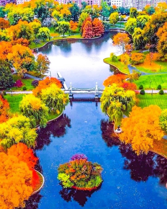
Boston Public Gardens, Boston, Massachusetts, United States: The Public Garden, also known as Boston Public Garden, is a large park in the heart of Boston, Massachusetts, adjacent to Boston Common. Wikipedia
159 notes
·
View notes
Text
THE REAL TURTLE ISLAND

6 notes
·
View notes
Text
North Yungas Road, Bolivia: The Yungas Road, popularly known as The Death Road, is a 64-kilometre long cycle route linking the city of La Paz with the Yungas region of Bolivia. It was conceived in the 1930s by the Bolivian government to connect the capital city of La Paz with the Amazon Rainforest in the north part of the country. Large parts of it were built by Paraguayan prisoners during the Chaco War. Several sections of the road are less than 3 metres wide, and due to presence of rain, fog, landslides, cascades, steep slopes and cliffs that drop more than 610 meters or 2000 feet, it is largely considered the most dangerous road in the world. Wikipedia
#North Yungas Road#city of La Paz#Yungas region#Amazon Rainforest#Bolivia#south america#south american continent
206 notes
·
View notes
Text
no offence to hozier but his tour locations are literally this meme
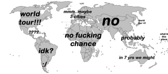
#hozier#hozier tour#“world tour” my arse#you ain't slick andrew#i'm not really mad i expected this but it's still annoying#come to australia challenge#or like. anywhere outside north america and europe#there are a few south american locations so that's something i guess#but there's nothing even in the continent where i live
218 notes
·
View notes
Text

I like to happily report that fat fuck made it to the beach my goal of this trip has been completed
#murder drones#crow uzi#darkxwolf17#murder drones uzi#she’s so dirty now but it was so worth it#this little fucker has travled across the North American continent#maple says stuff
26 notes
·
View notes
Note
Earth is a terrestrial planet, despite 70% of it's surface being covered in water. It has a molten iron core, and has existed for about 4.5 billion years. It's the third planet out from it's star (a yellow dwarf).

The Cartologist: Oooh, interesting, is there more?


The Cartologist: Oh, is that what the song about cheese comes from?


The Coordinator: Yes, mortal planets that have had life for a long time do tend to experience multiple extinction events, which is one of the reasons it is important we tend to our duties.
#toh#the owl house#ask blog#ask the archivists#asks are open#id in alt text#toh oc#meteor shower event#second anon I must inform you that I was always taught there are 7 continents and 5 oceans#and as a north american you combining north and south america#but keeping asia and europe separate even though they're more of a singular landmass than the americas#I had to stare out the window into the inky void of space#also you forgot the continent of antarctica#Also why are you including SEAS in the OCEAN count?#sorry if it sounds like I'm beefing with you on any serious level I am just genuinely baffled#Might as well call the great lakes an ocean if you're counting the black sea#And count the Caspian sea since that's the same size as the Black sea#fuck it any body of water you can't see across is now an Ocean#We live on water world let's exploit that and give ourselves an insane number of oceans#just like how I learned the Earth doesn't have an agreed upon name by the whole world#I am now shaking the ENTIRE earth so we can all agree upon a standard model for oceans and continents#like please for the love of god can we be on the same page *sobbing emoji*#I don't even care if the model I was taught becomes outdated#I just think we should all agree about something basic like the number of oceans and continents on this planet
21 notes
·
View notes
Text
One thing I'd love to see Magpie lean into for the FLTTRPG is the opportunity deck. They mostly do PbtA and should continue in that genre, but the idea of having a deck of custom one-shot moves local to each region goes hard.
I do have high hopes for it, FB seems likely to be involved deep in the development compared to the Avatar game so it'll probably be strong.
#fallen london#I have STRONG OPINIONS about TTRPGs#when that drops I'm 100% gonna run or play it. I don't know who with but I will find a way.#If I'm not satisfied I will work on my own. I have a feeling the playerbase is the right level of crazy to be on board with that#I've been playing FL for a month but the world has been deep in my head since I died seventeen times in one session of SSeas#I already have a seed doc of a game in the lineage - wild west in a shifting psuedo-north-american-continent. you have a funny covered wago#oh that's. that's ultraviolet grasslands. I accidentally invented UVG before I knew about UVG. Not exactly but the overlap is massive#It's so cool that similar ideas come up. especially because now that I know more about the FL setting and UVG I'd make one further from bot#I might return to that game idea. i just opened it up to peek and wow my fingerprints are clear all the way from 2022#I love making posts where the greater half of the content is in the tags. I'm so good at blogging on Tumblr Dot Website
8 notes
·
View notes
Text

Puerto Vallarta, Mexico: Puerto Vallarta is a Mexican beach resort city on the Pacific Ocean's Bahía de Banderas in the Mexican state of Jalisco. Puerto Vallarta is the second largest urban agglomeration in the state after the Guadalajara Metropolitan Area. The City of Puerto Vallarta is the government seat of the Municipality of Puerto Vallarta, which comprises the city as well as population centers outside of the city extending from Boca de Tomatlán to the Nayarit border (the Ameca River). Wikipedia
185 notes
·
View notes
Text

Faneuil Hall Marketplace, Boston, United States: Faneuil Hall is a marketplace and meeting hall located near the waterfront and today's Government Center, in Boston, Massachusetts. Opened in 1742, it was the site of several speeches by Samuel Adams, James Otis, and others encouraging independence from Great Britain. It is now part of Boston National Historical Park and a well-known stop on the Freedom Trail. Wikipedia
143 notes
·
View notes
Text
everyday europeans find new ways to piss me off
#🍯 talks#like how are u gonna constantly call americans stupid and act like ur better#and then when an american brings up the number of top unis in the usa vs europe#all of the sudden ur yapping abt 'why do americans wanna make everything a competiton'#like its fine for u to act like were inherently dumber than u bc were american but its an issue if we defend ourselves#jesus fucking christ#and ofc its not all europeans blah blah blah#and ik its gotta be like an annoying loud minority that feel emboldened by being online#still doesnt mean it wont annoy me when hundreds of them all congregate in the comments of one americans videos#and the whole 'americans think europe is a country' bc americans refer to it as a whole as europe#like.... im not gonna individually list out all 44-50 countries when i can just say euopre#'euro summer' and they get sooooo pissed#'americans are so stupid they dont even know that europe is a continent and not a country'#now if we use our brains and some common sense maybe we could figure out why someone might refer to a trip where theyre visiting multiple#european countries as 'euro summer'#i do that in the us too#when i visited a bunch of states in the north east i said i went to the northeast#also in america 'im visiting europe' is an invitation to ask which countries in specific and continue the conversation#and when they act like they know more than americans abt america#just bc they watched disney channel and friends
14 notes
·
View notes
Text
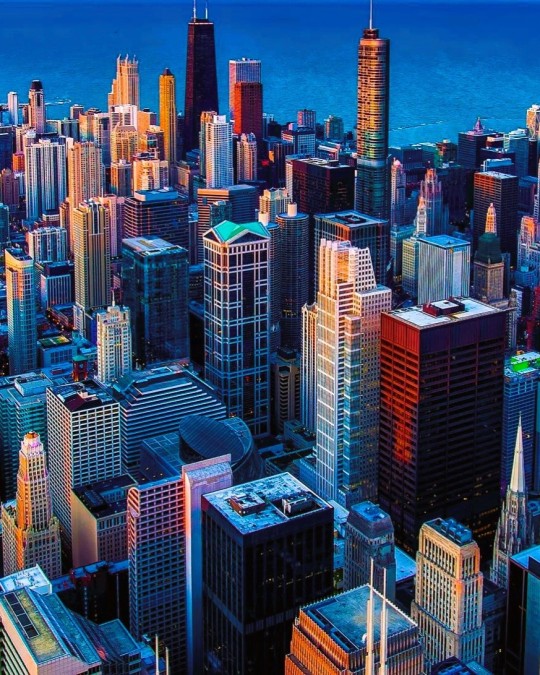
Chicago Skyline, U.S. state of Illinois, United States: Chicago is the most populous city in the U.S. state of Illinois and the third-most populous in the United States after New York City and Los Angeles. Chicago is the center of the Chicago metropolitan area. Wikipedia
147 notes
·
View notes
Text
not to sound like a 13 year old but i've got particular beef with the idea of the districts of panem lining up with the geography of north america like i Get it i've seen the maps i understand the intent of the author and how it makes sense culturally but deep down inside it just feels wrong to me and i can't do it.
it's like u say "nuclear war wiped out most of the planet" and that's supposed to make me accept that the extraordinarily strong culture of american statehood just collapsed into 12 regional districts like that?? fine i guess if we account for a long long gap of time between nuclear war and the original inception of panem. maybe.
but also. the way it's described clearly implies each district is able to gather its entire population in one square on one day for reaping day and honestly strongly implies that each district + the capitol are comprised of only one urban center (of varying sizes) each implying that the area of these districts Has to be so much fucking smaller than it appears on any of the maps that float around. where is all the empty space. the north american landscape is Huge even with the amount of coastline taken away due to oceans rising and that space is like. a huge huge factor in living here. there is not that sense of geographic scale and empty spaces between districts except like. the forests outside of 12 (speaking of like. katniss is able to walk the entire fence by herself in less than a day to check for weak points. these districts are small. even if 12 is smaller than say 11. that's ridiculously tiny all of these districts have to be small and definitely not entire regions of the continental united states)
also many many other ppl have made this point lmao but. the foreign policy of panem is not mentioned except for those vague notions of a nuclear war in the distant past and it is just. stretching imagination beyond belief to imagine that if panem truly is north america president snow literally is only concerned with domestic policy even the most isolated authoritarian regimes on earth today still have to deal with foreign policy on some level (and north america is lucky to have near self sufficiency w resources bc oil and such but. we do not have rare earth metals to sustain the technology level of panem. i'd be willing to discuss the hypothetical that panem has zero computers and batteries it's not impossible but.)
all in all it's very clear that culture/resources of 12 is inspired by and modeled on appalachia and that the more extreme repression/resources of 11 are inspired by and modeled on agriculture and racist government styles of the deep south etc etc and that makes sense bc like. suzanne collins is deeply entrenched in american culture and so is the hunger games as a series and she absolutely nails the culture and political connections bc it's an extremely adept commentary on modern american society but. the geography just doesn't make sense and raises too many questions and i wish you all would accept like me that it takes place in a fantasy land of pure allegory
#the handmaid's tale version of america and the uglies version of america i do accept.#bc they both have clear ties to the past Before dystopia got put in place and have govt's concerned w foreign policy!!!#and in the uglies series for example there is a sense of the geographic scale of the north american continent despite the current populatio#being packed into self sufficient urban centers#plus!! other countries!!!!!!!!!!!!!!!! they go to japan!#the hunger games
22 notes
·
View notes
Text

Christ Church, Georgetown, Guyana: Christ Church is located on Waterloo Street, North Cummingsburg, Georgetown. The church was established in 1834 as a proprietary chapel and was formed by 16 former members of the St. George’s Cathedral who wanted a simpler form of worshipping than that practiced by the cathedral... Georgetown is the capital and largest city of Guyana. Wikipedia
#Christ Church#Waterloo Street#North Cummingsburg#Georgetown#Guyana#south America#south american continent
100 notes
·
View notes