#lake shasta
Explore tagged Tumblr posts
Text

A family enjoys their houseboat on Shasta Lake.
California
1970
#vintage camping#campfire light#california#lake shasta#history#houseboats#travel#camping#road trips#fishing#swimming#1970s
75 notes
·
View notes
Text
Lake Shasta level rising, with more rain on the way. How close is it to being full?
Jan. 16. 2024 - Record Searchlight
Lake Shasta, California’s largest reservoir, stands at 113% of the historical average and only 52 feet from being full, thanks to the gift of rain the state is receiving so far this winter.
The area received about 1.8 inches of rain last Friday and Saturday, National Weather Service data for the Redding Regional Airport showed.
As of Monday, the lake was at over 1,015 feet of elevation above sea level, which places it 52 feet from its brim, according to the California Department of Water Resources...
The Golden State had one of its wettest years on record... in the 2023 water year.
#orgone#orgone energy#orgonite#lake shasta#california#reservoir#water#geo-restoration#free energy#weather#climate#drought#record rainfall#record snowfall
3 notes
·
View notes
Text

Spent the day kayaking around⛵️
8 notes
·
View notes
Text
Photos Show Dramatic Difference in Water Levels at Lake Oroville From 2021 to Today, Now at 100% Capacity
A record wet season has led to California's second-largest reservoir filling up.
— ByJulia Jacobo | June 19, 2023
California's Lake Oroville, one of the many important reservoirs in the West that reached critically low levels during the height of the megadrought, is now filled to the brim.
Before and after images of Enterprise Bridge offer a sharp comparison for Lake Oroville between July 22, 2021, and June 15, 2023, after the reservoir, the second-largest in the state, reached full pool for the first time since 2012 -- and only the second time in the past 15 years, according to the California Department of Water Resources.

In this before-and-after composite image, a comparison of water levels at Lake Oroville between July 22, 2021, and June 15, 2023. Justin Sullivan/Getty Images
In September 2021, water levels in Oroville dipped to their lowest ever at 628.47 feet, at just 24% capacity. As of Monday, water levels neared 900 feet -- more than 100 feet higher than this time last year. Not only are water levels at the lake currently measuring at 100% capacity, they are at 127% of where they should be around this time of year, according to the DWR.
Storage at Lake Oroville has risen more than 240 feet and gained more than 2.5 million acre-feet of water since Dec. 1, according to the DWR.
The improving drought conditions in California are "a stark difference" from the last three years, California Department of Water Resources director Karla Nemeth said.
Oroville can hold 3.5 million acre-feet of water, with the peak flow from the snowpack in the Sierra Nevada mountains occurring in April as temperatures began to rise quickly in the region. Some spots in the Sierra Nevada mountains received up to 200% more snowpack than normal due to repeated rounds of atmospheric rivers that slammed the West Coast during the winter season.
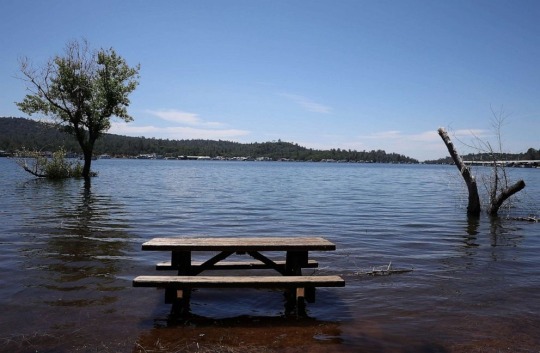
A picnic table sits partially submerged in the waters of Lake Oroville, June 15, 2023 in Oroville, California. Justin Sullivan/Getty Images
Melting snowpack continues to contribute to nearly full reservoirs in the state. Lake Shasta, California's largest reservoir located about 120 miles north of Lake Oroville, is also close to full pool, nearing 97% capacity as of last week, according to the California Department of Water Resources. The San Luis Reservoir in Merced County, the fourth-largest in the state, is currently 99% full.
"It’s refreshing to see Lake Oroville and other State Water Project (SWP) reservoirs like San Luis near or at capacity," Nemeth said.
In April, when Lake Oroville was measuring at 91% capacity, the DWR announced the State Water Project would be delivering 100% allocation for the first time since 2006.
The department is continuing to optimize operations for water storage and environmental protection for the water delivery needs to 27 million Californians and 750,000 acres of farmland, Nemeth said. These operations will also allow for carryover storage into next year, she added.
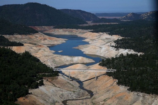
A section of Lake Oroville is seen nearly dry, Aug. 19, 2014 in Oroville, California. Justin Sullivan/Getty Images
Officials began ordering the strategic release of water as soon as the melting began, fearing the devastating flooding that would occur from the rapid warm-up in temperatures. Those releases could temporarily increase to keep up with increasing water flows and maintain safe water levels.
Earlier this month, total releases to the Feather River amounted to 8,000 cubic feet per second (cfs). An additional 4,000 cfs was released from the Thermalito Afterbay River Outlet, located 5 miles downstream from Oroville, according to the DWS.
The department is "closely" monitoring the inflow of water runoff into the lake -- as well as evaluating the lake levels and downstream needs -- to determine how much water to release at any given time, Nemeth said.
Oroville Lake sits behind the tallest dam in the country, the Oroville Dam at 770.5 feet, and provides hydroelectric power to the Edward Hyatt Power Plant, the fourth-largest in the country.
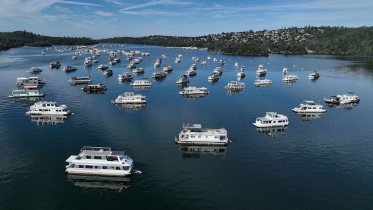
In an aerial view, houseboats sit anchored at Bidwell Canyon Marina on Lake Oroville, June 15, 2023 in Oroville, California. Justin Sullivan/Getty Images
The plant was forced to close in 2021 when the record-low water levels were too low to flow downstream. In 2017, nearly 200,000 residents living near Lake Oroville, located about 75 miles north of Sacramento, were forced to evacuate after heavy rainfall damaged the dam's spillways, which could have allowed for uncontrolled floodwaters to release downstream.
Those spillways were rebuilt "to the highest engineering design and safety standards, and continue to operate as intended and designed," Nemeth said.
4 notes
·
View notes
Text
youtube
Just finished producing "CAST THEN BLAST 2025" enjoy!
0 notes
Text



1 note
·
View note
Text

Encampment at the Base of Mount Shasta by Andrew W. Melrose
#andrew melrose#andrew w melrose#art#encampment#camp#camping#fire#mount shasta#california#stratovolcano#siskiyou county#volcano#volcanoes#mountain#mountains#landscape#forest#america#north america#american#trees#lake#lakes#nature
326 notes
·
View notes
Text

Beautiful Lake Siskiyou, Mount Shasta, CA.
#photography#photooftheday#adventure#landscape#lakeside#mount shasta#nature#naturecore#forest#mountains#lake#california#explore
32 notes
·
View notes
Video
I’m Off to Explore Lassen Volcanic National Park by Mark Stevens Via Flickr: While walking along the Manzanita Lake Loop with a view looking to the southeast across the waters of Manzanita Lake. This is in Lassen Volcanic National Park. Lassen Peak is the backdrop beyond an opening in the trees. My thought in composing this image was to take advantage of this opening and what I felt were the layers present from the nearby thicket and woods, to the more distant shoreline with the forest of trees, and finally ridges and peaks. I also liked the balance between the trees and forest with the reflections off the waters.
#Azimuth 134#Blue Skies#California Cascades#Cascade Range#Day 1#DxO PhotoLab 8 Edited#Evergreen Trees#Evergreens#Forest#Forest Landscape#Glass-like Reflections#Lake#Lake Reflections on Water#Landscape#Landscape - Scenery#Lassen Peak#Lassen Peak Area#Lassen Volcanic National Park#Lassen Volcanic Shasta Napa#Looking SE#Manzanita Lake#Manzanita Lake Loop#Manzanita Lake Trail#Mountain Peak#Mountains#Mountains in Distance#Mountains off in Distance#Mountainside#Nature#Nikon Z8
5 notes
·
View notes
Text


i love this little family, and how much fun they have together. thanks for sharing, natalia.
#There's a few photos she posted with matt and his family in Vancouver#I will cry#And I think these ones were around north California?#Lake Shasta I think#Also Isaac has a special persoooonnnn#Cuuuute!#I think Mike is the only one who's single? Hajsha.#You go Mike!#Anyway... They're all my best friends you see
45 notes
·
View notes
Text


California was admitted as the thirty-first U.S. state on September 9, 1850.
California Admission Day
California Admission Day is observed on September 9 each year. It commemorates the day California was admitted into the Union as the 31st state in 1850 after it was ceded to the United States by Mexico in 1848. California became one of the few states to become a state without first being an organized territory. California Admission Day is not a federal holiday. Rather, it’s a local observance in the state, which implies that businesses, schools, and government offices remain open. In times gone by it was celebrated with great pomp and ceremony with parades and pageantry. Though low-key now, the day still marks an important part of Californian history.
History of California Admission Day
The Mexican-American War began in May 1846 when the U.S. declared war on Mexico. American settlers who lived in the territory of California in Mexico revolted against the Mexican government in what is known as the Bear Flag Revolt. The Americans captured Sonoma, hoisted a Bear Flag in the area, and declared it the California Republic. On July 9, 1846, Navy Lieutenant Joseph Warren Revere arrived in Sonoma and replaced the Bear Flag in the territory with a United States flag. Lieutenant Revere officially declared California a possession of the United States. In February 1848, Mexico and the U.S. signed the Treaty of Guadalupe Hidalgo to end the war. This treaty meant that Mexico had to yield a large portion of its Southwest territory — including present-day California — to the U.S.
As of the signing of the treaty, California had a meager population that was not up to the 60,000-inhabitant benchmark a territory needed to achieve statehood. Earlier in January 1848, gold was discovered on the American River near Sacramento, and the territory witnessed a massive influx of immigrants looking for work and good fortune. Thanks to the Gold Rush, a huge increase in population and wealth followed, thus necessitating the need for civil government and local policies.
In 1849, Californians demanded statehood, and California became the 31st state on September 9, 1850. California joined the Union as a free, non-slavery state by the Compromise of 1850 in just about two years of the territory’s incorporation. Its first capital was in San Jose before it was moved to the city of Vallejo for lack of necessary facilities. The capital was later moved to Benicia, a small town, and subsequently to the riverside port of Sacramento in 1854.
California Admission Day timeline
1846
The Bear Flag Revolt
American settlers in California stage a revolt against Mexican authorities.
1848
A Treaty for Peace
The United States and Mexico sign the Treaty of Guadalupe Hidalgo to end the war between the countries.
1850
The Compromise of 1850
The Compromise of 1850 is signed and California is admitted as the 31st state to the Union.
1911
Adoption of the California State Flag
The California State Flag, based on the original Bear Flag, is adopted by the state legislature.
California Admission Day FAQs
Is California Admission Day a federal holiday?
California Admission Day is not a federal holiday. It’s a local observance in the state of California. Schools, businesses, and government offices remain open.
What are other names for California?
California is also known as ‘The Golden State, ‘The Land of Milk and Honey,’ ‘The El Dorado State,’ and ‘The Grape State.’
What is California famous for?
California remains one of the most popular destinations throughout North America. The state is especially famous for Hollywood, Disneyland, and the Golden Gate Bridge. Other unique landmarks in California include Coachella, Silicon Valley, the Wine Country, and Surf Culture.
California Admission Day Activities
Visit the Golden StateIf you’re a history buff, today’s the perfect day to visit California. Museums around California offer various resources and artifacts to help you learn more about the state’s rich history. Take a day trip or make a holiday of it and travel to more than one.
Enjoy the special eventsCalifornia Admission Day is observed with special events at schools, museums, and organizations throughout the state. Public officials often grant special addresses about its history and significance.
Take a trip to SonomaCalifornia Admission Day has been observed particularly in the Sonoma area since 1850. It would be nice to visit the area where it all began. Don’t forget to enjoy the state’s beautiful beaches, valleys, and mountains as you celebrate with them!
5 Fun Facts About California
Originally named “the Grizzly Bear State": California has renamed the Golden State from its initial name “the Grizzly Bear State” as the bears went extinct.
The state motto is ‘Eureka!’: The Greek word means “I have found it!” and alludes to the discovery of gold in the Sierra Nevada.
Redwood is the official state tree: California’s official state tree is the redwood, as designated in 1937.
It’s called ‘The Grape State’, too: Over 300,000 tons of grapes are grown in California annually, and the state produces more than 17 million gallons of wine each year!
Blue jeans: In 1873 blue jeans were imported for miners from Europe, making San Francisco the first place in the U.S. where jeans were worn.
Why We Love California Admission Day
Becoming a recognized state in the U.S.This event celebrates the day California officially became a state in the U.S. It was a protracted struggle but thanks to the peace treaty that ended the Mexican-American War of 1848, it was a done deal.
A tribute to the war heroesThe struggle to acquire California as a possession of the U.S. was not an easy one. It took a war, diplomacy, protests, and legislation to make it possible. This day celebrates the memories of everyone who fought to make it possible.
The population boost that came with the Gold RushCalifornia’s low population would have hindered its prospects to become a state and admittance to the Union. Thanks to the Gold Rush, the territory was able to have the 60,000 inhabitants it needed to achieve statehood.
Source
#Caples Lake#Red Bluff#Hess Persson Estates#Mount Shasta#California#31st US State#9 September 1850#Pacific Ocean#San Francisco#Sierra Nevada#Yosemite National Park#Morro Bay#Sonoma#San Diego#Humboldt Redwoods State Park#Los Angeles#Death Valley National Park#travel#original photography#vacation#tourist attraction#landmark#architecture#cityscape#landscape#USA#Lake Tahoe#Santa Monica#anniversary#US history
5 notes
·
View notes
Photo
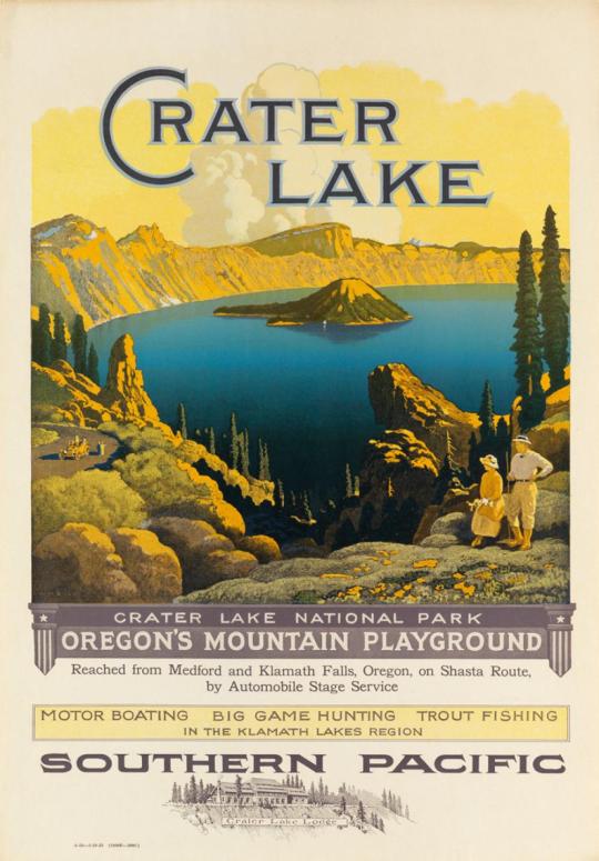

W.H. Bull 1861-1940
#trains#art#posters#railroad#railways#Oregon#pacific northwest#crater lake#shasta county#southern pacific#steam engine
20 notes
·
View notes
Text


Took a quick road trip and passed by Mt. Shasta, ( Siskiyou County, California.) I've only seen it one other time many years ago, but believe me, once you've seen it you'll never forget it. It's just suddenly 'there', all beautiful and majestic.

#road trip pictures through the window#for like 30 minutes you have opportunities to take pictures until it is gone from good vantage points#I'd like to actually visit the town of Mount Shasta one day#you can rent houseboats on Shasta Lake#put it on my to do list#😊#my husband is jealous because i am in love with this mountain 🤣
10 notes
·
View notes
Text


Some of the better ones I caught today at Lake Shasta. Spotted Bass
0 notes
Text
Wed 7/24
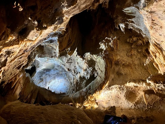
After breakfast at our hotel, we headed to Lake Shasta Caverns for a tour. It consisted of a boat ride across the lake, a bus ride up to the cavern entrance, and an hour-long tour inside (including a climb of several hundred stairs). Although formed as the result of volcanic activity, the caverns aren’t lava tubes, and they have many beautiful cave formations- stalagmites, stalactites, soda straws, cave bacon and curtains. Larger rooms included the Basement and the spectacular Cathedral. Fanciful formations pointed out included Chewbacca, a King & Queen, and a LlamaCorn. We also saw a lone bat flying in the Cathedral room. After exiting the caverns far above the entrance, we descended many steps to return to the bus. Fun was had even in the 100+ heat! After resting in our room for a couple of hours, we drove north to Basshole Brews for beer and fried food. At least the Eel River Amber was good!
1 note
·
View note
Text

Louis at Shasta Lake, California 28/6/23
#fit ..and he knows it haha#sunkissed sun#louis#day off#shasta lake#28.06.23#posted:#31.12.23#m#i think those are oli’s sunnies…
3 notes
·
View notes
