#California Cascades
Explore tagged Tumblr posts
Visit Tumblr Blog
Explore Tumblr blogs with no restrictions, modern design and the best experience.
Last Seen Tumblr Blogs


Fun Fact
Tumblr was acquired by Yahoo for $1.1B in 2013.
Text


Forest (No. 53)
Burney, CA
#Burney#Shasta County#California#USA#travel#original photography#vacation#tourist attraction#landmark#landscape#countryside#mountains#summer 2023#forest#woods#flora#nature#Burney Mountain#Cascade Range
425 notes
·
View notes
Text

144 notes
·
View notes
Text

Hiking through the season's first dusting in the Trinity Alps
Northern California
1994
#vintage camping#campfire light#california#trinity alps#mount eddy#shasta cascade#camping#history#hiking#backpacking#1990s
117 notes
·
View notes
Text
Nobody does it like these five, they're the baddest bitches in this system


317 notes
·
View notes
Text

Bumpass Hell
Lassen Volcanic National Park, California
Oct. 2020
#lassen#lassen volcanic national park#travel#nature#nature photography#landscape#photography#photographers on tumblr#original photography#lensblr#national park#national park service#california#cascades#landscape photography#wanderingjana
28 notes
·
View notes
Text
have always been skeptical of state or regional-level secession movements because I generally feel that more borders do not solve anything but also if California put secession on the ballot right now I'd have a hard time not enthusiastically voting yes
#not to be a cringe west coast liberal about it because obviously california has massive problems and is not some kind of lefty paradise#but given today's events i think i'd take my chances#washington and oregon west of the cascades can come too
17 notes
·
View notes
Text


globster sighting 6
#my photos#California#Año Nuevo#Cascade Creek Beach#ocean#kelp#kelp globster series#got another pile of kelp that looks like a creature#I couldn’t get any closer because of how strong the waves were#and how high the tide was#but I think these look pretty good
8 notes
·
View notes
Text

Have seven . . .
#bike dog brewing#dog years#west coast ipa#bike dog#good people deserve good beer#dog years ipa#citra#cascade#west sac#california#independent craft#your best friend loves this beer#beer
8 notes
·
View notes
Text


Nubieber, CA
State Route 299 (SR 299) is an east–west state highway in the U.S. state of California that runs across the northern part of the state. At 305.777 miles (492.100 km), it is the third longest California state route, after Route 1 and Route 99, and the longest east-west route. Route 299's western terminus is at US 101 at the northern edge of Arcata, and its eastern terminus is at the Nevada state line at a point east of Cedarville. Between Arcata and Redding, Route 299 intersects with State Route 96, and is briefly co-signed with State Route 3. In Redding, it intersects with State Route 273, State Route 44, and Interstate 5. East of Redding, it intersects with State Route 89, and a section is co-signed with State Route 139 before reaching Alturas. It is then co-signed with U.S. Route 395 northeast of Alturas, and then runs east through Cedarville and to the border with Nevada. A ghost town, Vya, Nevada, can be reached via this route, which after the border becomes a dirt road, which was formerly Nevada State Route 8A. The segment of SR 299 between Arcata and Redding is the Trinity Scenic Byway, a National Forest Scenic Byway.
Source: Wikipedia
#Lassen State Hwy#Nubieber#California#flora#travel#original photography#vacation#tourist attraction#landmark#landscape#nature#USA#summer 2023#street scene#hills#forest#meadow#woods#fir#tree#blue sky#clouds#Lassen County#view#mountains#Route 299#Cascade Range
20 notes
·
View notes
Text
the problem with building out america's rail network btw is that it's privatized and there will never be a corporate incentive strong enough or backed enough to implement effective, accessible, AND privatized countrywide travel. nationalize railways deliver on the demands of railway workers and most importantly respect indigenous sovereignty/include indigenous design input when plotting routes
#and a million other things mostly to do with geology but in terms of politics and morals this is what im going with as far as a snappy#summary of 'the problem'#however geology elaboration: america is So hard to build railways across because our most populated areas along the west coast#(where most of the rail drought is; rail PRICING on the east coast is a whole nother thing)#are stupid mountainous. the california hsr plan is spending several million more on the rail line bc they gotta plan around a mountain#and the problem gets worse the farther north you get on account of the cascades and ESPECIALLY the region around shasta#in another life i was a seismic engineer. anyway#i'm looking for a papers or other peer-reviewed content on the history of american rail labor#if anyone has favorites send them my way cause all my research is locked on california and the pacific coast more broadly#'research' my font of pdfs i downloaded from ILLs lol
35 notes
·
View notes
Text

song of a california quail mixed media photography, wax on wood panel
Available only on artful home: https://www.artfulhome.com/navigate?searchTerm=yuko
#nature#healing#portrait#bird#mixed media photography#artfulhome#quail#wildlife photography#pnw photography#north cascades#california quail
3 notes
·
View notes
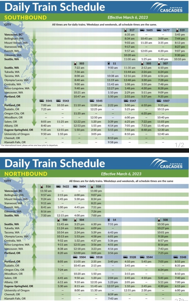
Note
I don't see timetables on the amtrak web page, just hours when a station is open. Should I plan on getting to the station I'd leave from hours before the one I'd arrive at would close? (Would be a couple hours in a car)
The app usually will schedule to allow for a few hours of time to get a transfer. You can get time tables by looking up the name of the route then "timetable" in a search engine. Here are a few timetables to help though
San Jaoquins
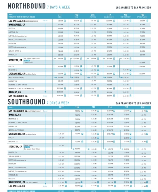
California Zephyr
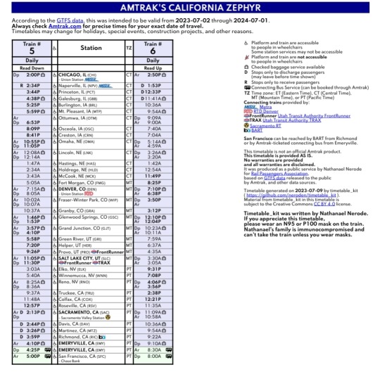
Capitol Limited
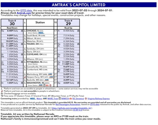
Cascades
49 notes
·
View notes
Text
The Center for Biological Diversity today petitioned for federal protection of Sierra Nevada red foxes in the Oregon and California Cascades, from Lassen Peak to Mt. Hood. The petition asks that the fox be listed as a threatened or endangered species under the Endangered Species Act.
“These precious mountain foxes need our help if they’re going to have any chance at survival in our rapidly warming world,” said Noah Greenwald, endangered species director at the Center. “The problems facing the Sierra Nevada red fox are complex and mounting, as they are for so many species in the mountains of western North America.”
In response to a previous Center petition, the U.S. Fish and Wildlife Service protected a fox population near Sonora Pass in the Sierra Nevada as endangered. But in 2015 the Service denied the fox protection in the Cascades, citing lack of information.Since then, considerable research has shown that fox populations in Lassen, Crater Lake National Park, the Central Cascades and Mt. Hood are isolated, exceedingly small and facing multiple threats.
The fox once ranged throughout high-elevation areas of the Cascades in forests and alpine meadows. But the species has been lost from large portions of its range, including Mt. Shasta. Poisoning as part of historic predator eradication efforts and trapping were primary drivers of the fox’s historic decline.
Today the fox is threatened by habitat loss caused by fires, logging, livestock grazing and development, increased recreation and climate change, which is pushing the fox’s habitat off the top of mountains.
An additional threat is competition and predation from coyotes, which have proliferated in the Cascades in the absence of wolves. Coyotes are likely to move uphill as snowpacks recede with warming.
“The harms we’re doing to the natural world are accumulating and interacting in complex ways to the detriment of animals like the Sierra Nevada red fox,” said Greenwald. “Historic killing of predators, including wolves and the fox, have left the fox vulnerable to coyotes and risks inherent to small populations. And now, increased interest in outdoor recreation and global warming represent new and growing threats to the fox.”
The fox’s surviving populations are critically small. The population found in the Lassen area, for example, was recently estimated to contain fewer than 10 breeding adults. The other populations are not much bigger.
#ecology#enviromentalism#foxes#sierra nevada#red fox#oregon#california#cascade#endangered species act#endangered species#mt hood#lassen volcanic national park#let wolves live
4 notes
·
View notes
Photo

Once called the Eighth Wonder of the World by Teddy Roosevelt, Burney Falls is certainly a majestic sight! It’s also one of the most over-photographed spots in the western USA making it very hard to produce an image that doesn’t look like a thousand other images already in existence. Enter infrared photography. I’ve only seen one other infrared image of the falls prior to capturing it in invisible light myself. I captured this image with my full spectrum camera fitted with an 830 nanometer “deep infrared” filter. It was late on an early May afternoon when some unsettled weather was moving through the area making for some dramatic clouds overhead yet providing some sun to get that nice IR glow off the trees. Being a weekday in less than stellar weather, it also kept the crowd at bay and I had the overlook to myself for a time which certainly helped! Prints available: https://fineartamerica.com/featured/the-8th-wonder-infrared-mike-lee.html
#burney falls#mcarthur burney falls#waterfalls#beautiful waterfall#waterfallphotography#cascading waterfall#majestic#serenity#stunning#Black and White#Infrared Photo#infrared photography#Shasta County#Northern California#california photography#california#fine art photography#original photography on tumblr#orignal photography#nature photography#original photographers#photographers on tumblr
11 notes
·
View notes
Text
#my videos#California#Año Nuevo#Cascade Creek Beach#ocean#fog#beach#creek#little tiny waterfall in the lower left
2 notes
·
View notes
Text

If it ain't the truth, you shoreline . . .
#good beer brings good cheer!#endless shoreline#pizza port brewing co.#carlsbad#california#india pale ale#riwaka#waimea#nz cascade#crystal#columbus#independent craft#ipa
2 notes
·
View notes