#easternmost
Explore tagged Tumblr posts
Visit Tumblr Blog
Explore Tumblr blogs with no restrictions, modern design and the best experience.
Last Seen Tumblr Blogs


Fun Fact
Tumblr has been banned in Indonesia for providing people with access to pornographic content.
Text

Lubec Channel Light, Lubec, Maine. At low tide, the "Spark Plug" is virtually surrounded by mud. This mud is one of the top spots in the state for fall shorebird watching. Thousands of sandpipers, plovers and other little long legged birds make a stop here, to fatten up on worms and other small invertebrates, before making their way south for winter.
#Lubec Channel Light#Lubec#lubec#lubec channel#Lubec Maine#easternmost#easternmost town#spark plug#spark plug lighthouse#lighthouse#art#lighthouse illustration#maine#maine landmark#Lubec landmark#Maine lighthouse#drawing#design#lighthouse art#jada fitch#birding#shore bird#bird watching#bird maine#birding maine#birdwatching#Lubec mud flats#Lubec bar#mud flats#shobs
80 notes
·
View notes
Note
What’s the architecture/layout of old Bur, how do modern people perceive the ruins?
The city in its peak was very large and spread over both shoreline and a network of small islands. These islands comprised a waterfront district connected by a network of bridges and canals, where a large portion of its non-agricultural lower class lived.
It had a fairly well organized and efficient freshwater+sanitation system across most of its span (the canal district had less effective plumbing largely due to logistical difficulties, most of its wastewater was instead flushed by rain powered cisterns). The water system was powered by the Hsuke river and made fresh water readily accessible throughout the majority of the city (though few homes had direct freshwater plumbing). It had several major public baths, and the homes of the wealthiest members of society had their own private bathing pools.
In this part of the world, it is broadly regarded as once being one of the most beautiful cities to have ever existed. It was particularly noted for its water gardens (still a fixture of present day Burri culture) which were absolute marvels of engineering for that period, with the majority of these being entirely artificial and supported by its network of aqueducts. These hosted thousands of ornamental plants, fish, and fowl, as well as fruiting trees and shrubs. They were treated as a public work meant to benefit all citizens, and existed throughout the city.
The palace in particular was noted as impressive, in part for its architecture but mainly for its gardens. These hosted 'exotic' plants and a menagerie of animals from across the empire's territory, and existed in part as a symbol of the state's power and reach. It was a trend for emperors to bring in the fiercest animal from each conquered province to the grounds, with the an-nechoi being the beast of choice from the lands across the sea to the east, with one (Probably erroneously) cited as killing thirty servants in the process of moving it into the gardens.
The palace was located within the temple district. This district housed over a hundred shrines to the various lesser deities of the pantheon, and temple complexes to the seven chief deities (the firstborn gods who created the world, all other gods were later descendants). Old Burri temples were Kinda similar in shape to a ziggurat, though had an accessible interior space and a central tower which housed the shrine. At this time, the chief gods were believed to physically inhabit their temples. Each god had its own high priest permitted to attend to their shrine, with the emperor being the high priest to Inanariya (king of the gods) and the only person permitted to directly commune with this deity. The foundations to these temples are relatively intact in the present day, though none of the towers remain (collapsed in earthquakes with no one to rebuild them).
The city was heavily fortified, having one external wall surrounding most of its length, and an internal wall surrounding the palace/temple district (which doubled as a fortress).
---
The period of sea level rise began with a 500ish year period of mostly gradual increase, which occurred slowly enough that most infrastructure could adapt very easily and the problem went unnoticed by most (the city of Bur experienced most of its Growth during this time). It then culminated with about a century of (relatively) rapid rise, which is the direct cause of the city's abandonment.
The canals flooding had always been a problem during storms, but this began to occur with notable frequency, alongside the water level as a whole rising quickly enough to be noticed on an immediate human timespan. The canal district was maintained for a while by rerouting some of its waterways and building up barriers, but it was the first part of the city to be abandoned. Things got more serious when the mainland parts of the city grew increasingly impacted by storm surges that never seemed to fully retract, and major parts of its surrounding farmland were hit by surges and tidal waves, and rendered too saline to remain arable.
The actual single biggest cataclysm was the collapse of the city's mainland sewage system. It was built with flood canals as a failsafe, but these were built to withstand heavy rain rather than an encroaching ocean. Storm surges would cause large segments of the city to be flooded with sewage (including some of the freshwater plumbing), and serious disease outbreaks would follow.
These issues were enabled/exacerbated by earthquakes (the region is geologically active and this isn't unusual) that further damaged and mingled the sewage and freshwater systems. One earthquake and its subsequent tidal wave was a turning point, and the resulting breakdown of (already strained) infrastructure rendered a large swath of the city uninhabitable in the space of about a week. This also just caused immediate damage to much of the city's architecture/walls, and collapsed the tower of the temple to Inanariya (never a good sign). This is when the full exodus began, first with people flocking to un-flooded parts of its city and farmlands, and those who could afford it fully relocating to other cities/towns.
All of this issues were compounded by the 1st Burri Empire already being in a period of collapse at this time. This was largely a matter of simple overextension. Its borders were constantly under attack by rival states/its victims, sometimes with great success. Bur's own population had burgeoned well past what the imperial core land could sustain, and its cities relied predominantly on extraction of foreign grain/goods to feed their people. It lost most of its eastern land holdings in a fairly rapid timespan (overextended with wars at multiple fronts), which caused frequent famines in its core.
This put pressure on its final emperors to invest in increasingly desperate expansionist projects, while attempting to keep up public morale with lavish public works and objectively stupid vanity projects. The attempt to excavate a canal at the Viper seaway's 'tail' (one of the few eastern regions it retained secure control of at that point) was in part a desperate act to revive its economy by opening up/monopolizing a new trade system. The amount of money and manpower sunk into this ultimately doomed project was followed by Bur being fully ousted from its eastern holdings, and was one of the final straws in its collapse.
People in the city of Bur proper were dealing with the double front of starvation and their homes + streets + immediate water supply being flooded with seawater and literal human feces. These issues impacted the lower classes first and most severely, but ultimately transcended class boundaries. Famine grew more and more rampant, not only with the loss of the colonial holdings that supported the population but of farmland in the imperial core- much of the city of Bur's immediate farmlands were unproductive due to repeat inundation with saltwater during surges, and the farmland along the Yamage river to the north was rapidly being captured and pillaged by the Hsem (historical enemies, a nomadic group with a khait warrior culture from further west).
All this was fucking unlivable in of itself, but also had very obvious implications in the context of Burri emperors also being high priests and the chief intermediary between the gods and the people. Not only was the government failing to sustain its citizens to begin with, but signs of divine disapproval were deeply apparent.
So the last days of the 1st Burri empire were a chaotic period of civil unrest, most acute in and around city of Bur proper. This involved near-constant peasant revolts and several attempted coups. The last Burri emperor (of the First empire) ultimately fled the capital of Bur and reestablished in Titenegal, declaring it the new capital. This was then sacked by the Hsem within a year and after that it was fucking Joever.
The city of Bur was functionally abandoned by this point. People still Lived There and there were several attempts to set up a new government, all of which failed in the short term. After the collapse was complete, its inhabitants were mostly just peasants who built up new homes further inland and sustained themselves on the remaining farmland. Few people lived permanently in the city proper due to all of its intact infrastructure being effectively non-functional without the governmental bodies/human labor to sustain it.
---
It should also be noted that it was Extremely not just Bur that was flooded, the sea level rise was worldwide (resulting from a collapsing ice sheet) and almost Every coastal city during this period experienced the same issue. Bur's demise was just notably dramatic in that it was once the most heavily populated human city that has Ever Existed, and directly correlated with the fall of the empire it hosted.
The flooding was fairly gradual, but it's been 7 centuries since the first Burri empire's collapse and the fall of its capital city, and many contemporary records were lost to the immediate chaos and to the large span of time since. Cultural memory tends to reframe the flood VERY rapid on a human scale, many of the stories describe the city being swallowed in a single wave as an act of divine punishment (the popular notion at the time that the last emperors deeply displeased and shamed the gods has stuck into the narrative, often exaggerated into stories of them being horrifically debauched blasphemers guilty of the worst disgraces imaginable). Even more conservative accounts tend to imagine the totality of the destruction taking place over the span of about a year (merging the memories of the immediate earthquake devastation with more gradual elements of its slow flooding). People widely believe that most of its residents drowned in the city's cataclysmic demise, and that the ruins are now Extremely haunted.
The state of the flooding is not 'completely under the sea' and you can still walk/wade through most of the inland ruins (the canal district is effectively submerged, with most structures that Would be above the water level having collapsed against the strain). As such, some people Do Live Here. These people are mostly smugglers and pirates using the ruins as a hideout, and/or opportunistic hunters and fishermen who won't let ghosts stop them. Entering the city ruins is currently forbidden (largely Because of the criminal nature of basically every motive to go here (even hunting, which is considered poaching)), but enforcement of this rule/active patrols to prevent entry are inconsistent.
The majority of Old Bur's inhabitants are animals. The un-flooded parts of the city and its gardens are now a host to a thriving community of native plants and animals (and a few descendants of escaped non-native zoo animals/ornamental plants that adapted well to the conditions).
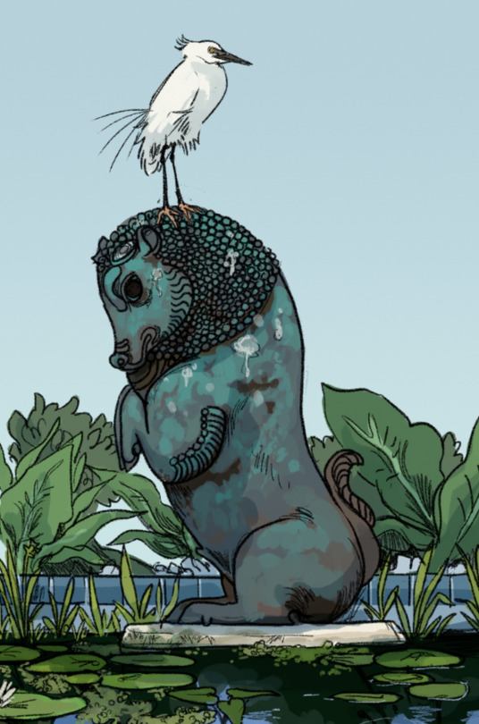
The egret shown here is a foreign species originally brought as an ornamental bird. In the centuries since its first import, it has become widespread and occurs on both sides of the Mouth seaway. It can hunt in both freshwater and saline environments, and a very large population lives permanently in the ruins of Old Bur.
Its common name is the ghost egret. Contemporary Burri folklore holds that the ghost egrets of Old Bur are literal ghosts, carrying the souls of those who died in the cataclysmic floods.
#[[JUST REALIZED you didn't even fucking. ask about the timeline of the flooding I just kinda went for it]]#[[its relevant to its contemporary state I guess????]]]#Added the photo without linking to the original post becasue it is WILDLY outdated.#Among other things I cited the population of the original city of Bur at 'over a million people'. Which is contextually ridiculous#Also (because this probably gets confusing) everything here describes the first of two empires out of Bur which was by far#the larger one. The second had a similar pattern in its downfall (overextension - famines at home - war and revolts at multiple fronts)#but was significantly less dramatic and had a much cleaner rebound (it ended in a successful coup that the contemporary#Burri Republic directly descends from)#I used to describe 3 Burri empires which. I don't know why I did that because the 1st of the three was an ANCIENT land empire#stemming from further west where contemporary Bur was its easternmost extent of Conquered lands. This collapsed like ~1500+#years before present and has no directly obvious impact on modern conditions whatsoever (it DID have major impacts#though: it's what first brought khait to this region and some of its ancient roads are still used in the largest continuous land#trade network in the northern hemisphere)
102 notes
·
View notes
Text
Sudan’s paramilitary Rapid Support Forces (RSF) and its allies have signed a constitution paving the way for the formation of a parallel government, a member of its coalition said Tuesday.
“The constitutional document was signed in Nairobi last night by all parties involved in the signing of the founding charter,” Ahmed Tuqud Lisan, a member of the preparatory committee of the Sudan Founding Alliance told AFP.[...]
Last week, the RSF and its alliance of political and military partners signed a charter vowing to establish a “government of peace and unity” in rebel-controlled areas of Sudan.
The “transitional constitution” signed on Monday documents the “tasks of the transitional period, the decentralised governing system and the structures of the executive authority,” Lisan said.
The next step would be to form the government, which will “be announced inside Sudan”, he added.
Kenya has been criticised for hosting the RSF and its allies, with Sudan’s army-aligned government recalling its ambassador in protest last month.
Sudan’s foreign ministry accused Kenyan President William Ruto of acting on “his commercial and personal interests with the militia’s regional sponsors”.
It is considered a reference to the United Arab Emirates, accused by Sudan and Western powers of backing the RSF, which it denies.
Kenya signed an economic partnership agreement with the UAE in January.[...]
The war between the RSF and the army has torn the country in two, with the army controlling the north and east, while the RSF holds nearly all of the western region of Darfur and swathes of the south.
4 Mar 25
#roughly the partition line i was expecting like 6 months ago#if rsf had kept khartoum that wouldve been a step change but saf pushed back quote significantly last few months#saf may try to limit rsf to have their easternmost front bounded by north khordofan bc theyre still quite close to Khartoum#question is materiel
47 notes
·
View notes
Text
woke up to see my neighborhood has been entirely surrounded by fire now :) literally on all sides
#it’s in a little pocket with a handful of other streets in the area#not sure if there’s even firefighters up there holding it back but. I assume there is?#when I was reading articles last night it said that the westernmost side of the fire was the worst#but there’s still stuff smoldering in the middle. but idk about the easternmost side where our place is#not sure how scary that is or if it’s more smoldering stuff that’s not as scary to look at#i say things
7 notes
·
View notes
Text

P-Jinx if I turned them into a genuinely fearsome western dragon of yore
Some notes under the cut:
Still can't breathe fire :( spits out high pressure super heated smoke though!!! Careful it's nothing but benzine - toxic gas! The pressure is high enough to stagger or shove and the heat is enough to cause the equivalent of a steam burn. Consistent spray can peel skin, they are immune to their own breath weapon-★
Can't fly either :( this means their presence is stealthy, well armored and speedy. They prefer to move quickly, quietly, and carefully
Prefers to knock out valiant knights and rob them of their glittery weapons and colorful banners for the hoard, makes sure to return the horse if it gets spooked
Not a knight? Brought things to trade like stories, gold, food, music? Wonderful you now have a giant lizard to guard you and or your camp, will GLADLY part with stolen banners, badges and other such things if it means you are lying to guards
Tail is most of their body length and used like a whip, the impact will liquify your insides. They tend to save this type of force for genuine threats like other dragons, large troops, or large familiars
Lives in a dug out rocky knoll that sits high in the mountainous foothills overseeing a well travelled road. Their territory consists of a large stretch of that road, a large sum of rocky forests, the side of mountain they occupy, and the entire village at the end of their road near the foot of their mountain face. Included are hundreds of fruit bearing plants, a fresh water stream with an enviable shallow spot with a surplus of fish, and a few healthy rabbit warrens and deer herds that they often fight to keep as their own.
★-Side effects of benzine poisoning are: Drowsiness, Dizziness, Headaches, Tremors, Confusion, Unconsciousness, and Irritation of the eyes, throat, skin and respiratory tract
Benzene has a sweet, aromatic, gasoline-like odor
They'd probably be around the size of two whole horses or more, not as large as most dragons but still formidable to a human
Some folklore style names for em:
Banner Eater - due to their petty theft of banners (used by the knights and merchants)
Redthroat The Noxious - poisonous vapors (used by the slayers and knights)
Blade Sleeper - lays atop a small mountain of stolen weapons (used by the slayers and knights)
The Bard Collector - lots and lots and lots of positive encounters with bards and polite travelers (their most common name, spread far and wide by the bards)
Jeweled Wisdom Thief - Just likes learning from people! (Suspicious bards and merchants like this name best)
Thundercrack - the noise their tail makes when fighting (merchants, mages, and scholars who are interested in dragons have investigated the inconsistent thunderous snap that can be heard for miles and are most likely to refer to them by this name)
P-Jinx The Gentle - non-hostile often dodging combat with mortals if it can be helped (their common/chosen name, and what they are referred to by locals and merchants, second most used name)
Old Diamond Eyes - pale blue, icy eyes that stare intently as you share tales and songs are what gifted them this name (mainly used among the bards)
Other notes:
Due to their polite and curious nature they aren't sought out often, but tales of a poisonous scaled siege weapon that lurks over a trade town makes wannabe slayers, knights and adventurers hungry for gold.
P-jinx will visit the village they call theirs often to check on the people there and to ensure no foul kingdoms are trying to unsettle their people with occupation or undue taxation. This is extra fun for them when slayers are present because they get to indulge their love of human song, stories, food and ale with these adventurers and their townsfolk. P-jinx of course always pays their tab and the tabs of their newest friends.
During bouts of boredom they will come down from the mountain to use their massive frame in tilling fields and hauling lumber to speak with and aid the townsfolk, other times coming in to trade treasures for comforts for their lair such as furs, tapestries, blankets, and the like.
Due to their frequent visits down the mountain adventurers and slayers often find the same well worn path up the mountain when the dragon is not in the town
#my art#dragon#dragon art#oc#sona#dragonsona#if I put them into Glore they'd probably end up being one of the easternmost coastal drakes that live in the volcanic island chains#<-#Glore
2 notes
·
View notes
Text
i find it lowkey funny that nova scotians call alberta and such "out west" because literally everything is west of us
3 notes
·
View notes
Photo
Photo by 若昔难得 (Flickr).
It's known as the "Old Dragon's Head", and it's the last part of the Shanhaiguan (or Shanghai Pass) where it reaches the Bohai Sea.

Map from Travel China Guide.

This is the end of the Great Wall of China.
#it's not necessarily the end of the Great Wall if we understand that as the Easternmost point of it#but yes and very cool place and very cool photo#china#travel
14K notes
·
View notes
Text
ニホンサイトウタン

日本の最東端は、北海道の北東端に位置する納沙布岬 (のさっぷみさき) です。この岬は、日本が誇る美しい自然景観と、その戦略的な位置で知られています。 納沙布岬は、北海道の根室半島の北東端にあり、オホーツク海と北太平洋の境界に位置しています。この岬は、その険しい崖、荒々しい海岸線、そして広大な海原の壮大な景色で有名です。
手抜きイラスト集
#日本最東端#Easternmost point of Japan#Punto più orientale del Giappone#Punto más oriental de Japón#Östlichster Punkt Japans#Point le plus oriental du Japon#手抜きイラスト#Japonais#bearbench#art#artwork#illustration#painting
0 notes
Text


Here it is: the largest set of collab adopts that @harriertail and I have done so far! This set is based off of all 50 of the United States. We split it up roughly into east and west, with Harrier designing the easternmost states and me designing the west.
We will return to our usual schedule of posting on the 15th next month. We hope you enjoy!
Please read my rules here before adopting (applies only to cats designed by me).
All of these designs are $30! DM the artist who drew the cat to claim please (either @needlepine or @harriertail). Check the labeled images above if you're not sure.
List of claimed/unclaimed adopts under the cut (go to the original post to see up-to-date status):
Alabama: CLOSED
Alaska: CLOSED
Arizona: CLOSED
Arkansas: CLOSED
California: CLOSED
Colorado: CLOSED
Connecticut: OPEN
Delaware: CLOSED
Florida: CLOSED
Georgia: pending
Hawaii: OPEN
Idaho: CLOSED
Illinois: CLOSED
Indiana: on hold until March 27th
Iowa: CLOSED
Kansas: CLOSED
Kentucky: CLOSED
Louisiana: CLOSED
Maine: CLOSED
Maryland: CLOSED
Massachusetts: CLOSED
Michigan: CLOSED
Minnesota: CLOSED
Mississippi: CLOSED
Missouri: CLOSED
Montana: CLOSED
Nebraska: CLOSED
Nevada: CLOSED
New Hampshire: pending
New Jersey: CLOSED
New Mexico: CLOSED
New York: CLOSED
North Carolina: on hold until March 27th
North Dakota: CLOSED
Ohio: CLOSED
Oklahoma: CLOSED
Oregon: CLOSED
Pennsylvania: OPEN
Rhode Island: CLOSED
South Carolina: OPEN
South Dakota: CLOSED
Tennessee: CLOSED
Texas: CLOSED
Utah: CLOSED
Vermont: CLOSED
Virginia: CLOSED
Washington: OPEN
West Virginia: CLOSED
Wisconsin: CLOSED
Wyoming: CLOSED
#cat art#adoptables#adopts#cat adoptables#warriors#warrior cats#warriors oc#warrior cat oc#i do not wanna hear ANYTHING about cats not being on their correct states!!! it was hard to get em all to fit nicely and#vaguely in the correct spots
1K notes
·
View notes
Text

West Quoddy Head Light, easternmost point in the US of A. PRINTS, TEES, TOTE, ETC.
#West Quoddy Head Lighthouse#West Quoddy Head Light#Quoddy#Quoddy Head#lighthouse#eastern most#easternmost#east#Quoddy Head Light#striped#candy striped#Maine#porcupine#illustration#jada fitch#art#drawing#design#Maine lighthouse#downeast#washington county#Lubec#Lubec Maine
140 notes
·
View notes
Note
q, b, L, h, s, andddd x for bothul
yess thank u... Hell Yeah
a little bit of background for Bothul below too ofc
Bothul is a big egotistical dragon who is convinced that she is The Best There Could Ever Be (as a lot of dragons, when they get big and old enough, are) and is trying to access Greater Powers for herself in a very specific way by digging into the ground in a weird magic-rich area and seeing what he can find and use. He has a gaggle of minions/followers that I'm working on making with my wife and a very devoted bard who brought a lot of their current competition for Bothul's attention to their dragon in the first place. You know how it is
B. Describe their family dynamic. - oohoho okay! Ever since Bothul was a little wyrm that popped out of his egg and was the only one of his siblings that survived to reach sentience (Dorna dragons work in an interesting way), she was her parent's Most Special Baby. Unfortunately for them, Bothul got too good at being the most special baby and probably took over a good portion of their territories after he became a young adult and got bigger than either parent. I think there's a certain amount of pride there, especially after she moved and wasn't stealing their (over-competed) food supply. Bothul would commend her parents on their support and correct decisions in making sure he ate as much as he needed to Get Strong.
H. Where is their favourite place to be? - Her Evil Lair.... genuinely though it probably is whatever setup he has down underground now. I think it's gotten to the point where Bothul doesn't feel super safe leaving, but that's because there are things that she doesn't have the capability to fight lurking around down there. Before it was likely still her lair - a well-furnished place with a hoard of magical items and expensive bits she's collected over the years is hard to beat, especially when there's a cool bard singing about how great you are while you chill.
L. What is their secrets to happiness? - Hands-down and without question, dominance.
Q. Do they have a signature look or fashion? - Bothul is currently stuck in non-designed hell, but he incorporates a lot of crystal armor and baubles in what he wears. VERY purple fashion overall as well, and likely a fan of intense eye makeup (maybe?? not too sure yet pff).
S. What’s their relationship like with their parents? - As explained above! Distant but he looks back on them about as fondly as a dragon usually does.
(A little extra here, Bothul's current 'family' - if it could be counted as such - is a bunch of people-pleasing suckups who are doing their best to either win Bothul's favor, kill a more-liked minion for power, and/or potentially wanting to kill Bothul himself to inherit all of his Very Powerful Items. Fun!)
X. What’s their biggest fear? - Whatever the biggest, MUCH more powerful thing is down below her. Her way of handling it is to try and maybe take the thing's power for herself, but she leans too hard into the pride and it WILL be her downfall.
#thank you for the ask!!!#c: Bothul#the last three have all been concentrated in the easternmost corner of Dorna god bless fghfjdk#it's weird in there
1 note
·
View note
Text
St. John’s, Newfoundland and Labrador, Canada: St. John's is the capital and largest city of the Canadian province of Newfoundland and Labrador. It is located on the eastern tip of the Avalon Peninsula on the island of Newfoundland. The city spans 446.04 km2 and is the easternmost city in North America (excluding Greenland). The closest European settlement is Fajã Grande, Azores, Portugal, about 2,000 km away. Wikipedia
377 notes
·
View notes
Text
Steadfast in defense, unshakeable in offense.

"My most unusual pupil, Varesa... nobody pulls off laid-back like she does. No matter where she goes, she acts like a little kid on a field trip — all she wants to do is try the local delicacies, then find a cozy spot to camp and sleep. But should you ever face the Abyss's monsters alongside her, look out. Once she dons her mask, her rush tactics can be... somewhat aggressive."
— Iansan
◆ Name: Varesa
◆ Title: Strength in Serenity
◆ Stalwart Warrior and Orchard Owner from the Collective of Plenty
◆ Vision: Electro
◆ Constellation: Mascara Luctatori

When discussing the Collective of Plenty's tribespeople, the first instinct of the Natlanese is to praise their "universal fitness," followed by a fond recollection of sweet fruits and fresh vegetables. Strength and abundance are the time-honored calling card of this tribe, with the most eye-catching pattern on that card coming from none other than Varesa's orchard—
As the cheerful call "Fresh produce from Varesa's!" rings out from the easternmost Children of Echoes to the Flower-Feather Clan in the far north, every tribesperson of every tribe can be sure that they shall enjoy healthy, all-natural, and delicious crops in the next few days to come. Her fruits are always intoxicatingly sweet, and her vegetables smack of rich, crisp petrichor — the taste of freshly rained-upon grassland bathed in sunlight. Over time, people have started erupting in heartsome laughter whenever they espy Varesa from afar, knowing a wonderful feast to be close at hand...
In the children's legends, a certain "Masked Hero" shall descend whenever evil beings and monsters run amok, wreathed in lightning. Charging at her foes with three times the ferocity of a Tatankasaurus, she delivers kicks as explosive as pyroclastic fallout, sending all the bad guys flying! The hero's battle cry when she executes her finishing move has become a popular catchphrase among the children, and the incredible swiftness of her departure is seen as the benchmark for "heroic speed"...
Astute observers would discover that the areas where the "Masked Hero" metes out justice overlap neatly with the Collective of Plenty's trade routes.
As was their duty, the Patrol Team approached their colleague, Varesa, asking if she had encountered such an individual, to which Varesa responded while scratching her head in bewilderment:
"Umm... That sounds a lot like me, though?"
At the unanimous nods of her team members, Varesa, who only just realized what they meant, suddenly felt shy. She vigorously shook her head, saying:
"I'll try harder next time — send the bad guys packing before anyone can even see them! But for now... I'm going to get something to eat first!"

#genshin impact#genshin impact updates#genshin impact news#official#varesa#she's cute i won't lie. i have some critiques but i can't deny that she's cute
323 notes
·
View notes
Text
Eyy look at that it's the lighthouse that inspired the drawing in my profile picture

#lighthouse#sea#ocean#no source#i actually know this lighthouse tho#its called the aniva lighthouse#its located at the easternmost bit of russia bodering japan#its powered by a nuclear battery and the soviets designed it to be fully automated so that it could run forever without human involvment#but it fell through the cracks once the soviet union fell#and it was left to keep on running until it eventually broke down and its nuclear cell was looted#and now it just kind of sits there haunting everyone with its presence#left to run until it breaks down entirely
508 notes
·
View notes
Text
PUTTING JORVIK ON THE MAP: SIZE AND LOCATION
WHERE IS JORVIK?
Finding Jorvik’s exact location is actually pretty easy.
”Jorvik, located somewhere between Norway, Iceland, and the British Isles, of which it was once part, is a nexus of worlds.” - Jorvik Calling, Prologue.

This is still a pretty large area, but one that’s significantly narrowed down by reading Four Stories from Jorvik. Anne’s segment Midnight Sun establishes that Jorvik is at the very least partly above the arctic circle, to the point where Anne can see it while riding by Jorvik Stables in the middle of the night. This also puts Jorvik pretty close to the tectonic rift between the European and American continental plates, which handily explains why Jorvik is a volcanic Island.

HOW BIG IS JORVIK?
Jorvik’s size requires a bit more speculation, and I’m relying on two book sources.
1: Jorvik stables is a bus trip from Jorvik city.
Anne lives in Jorvik City but goes to school with the other soul riders in Jarlaheim, and has her horse at Jorvik stables. We know that she goes there by bus, so the distance between Jarlaheim and Jorvik City shouldn’t be too large; I’m capping the max length of the bus ride to about an hour.
2: Valedale is less than a day’s ride from the wineyard.
In The Legend Awakens, Elizabeth and the soul riders are heading to Pi’s Swamp and sleep over at the Wineyard. The soul riders wake up late and leave after having eaten breakfast and lunch. The sun is ”at its highest point in the sky” when they leave, so probably around 1-2PM. It’s twilight when they arrive, and the Baroness comments that they showed up in time for the evening feeding of the horses. Since the days are shorter in late October/early November, which is when this chapter takes place, we can guess that they arrived at around 5-6 PM.

Mapping out the most likely routes for these two trips, the route to the Wineyard is about a third of the bus route from Jorvik City to Jarlaheim. Additionally, the bus would drive on average ~70 km/h because of Jorvik’s smaller roads. The average walking speed of a horse is 6 km/h.
Now, the Valedale-Wineyard trip could take anywhere between 3-5 hours, but I’m inclined to believe that it’s on the lower end of that scale to keep Anne’s commute as short as possible. That leaves us with a 18 km long ride, and a 54 km long bus tour that takes 46 minutes. Pretty reasonable!
RESULTS

With these new measurements, we can figure out the actual distance between different places on Jorvik. Most importantly, we can measure the absolute width from Jorviks westernmost to easternmost point: 92 km, or ~57 miles!
Having figured out an estimate of the island’s size and location, we can now put Jorvik on the map!

#sso#star stable online#star stable#ssoblr#Trying to make the math make sense between Anne’s bus and the trail ride was. not fun#but I’ll spare you the details#sso lore
542 notes
·
View notes
Text
Byron Bay, Australia: Byron Bay is a beachside town located in the far-northeastern corner of New South Wales, Australia (in Bundjalung Country). It is located 772 kilometres north of Sydney and 165 kilometres south of Brisbane. Cape Byron, a headland adjacent to the town, is the easternmost point of mainland Australia. It is the largest town of Byron Shire local government area, though not the shire's administrative centre (which is Mullumbimby). Wikipedia
210 notes
·
View notes