#bettergeology
Explore tagged Tumblr posts
Visit Tumblr Blog
Explore Tumblr blogs with no restrictions, modern design and the best experience.
Last Seen Tumblr Blogs


Fun Fact
China blocked Tumblr because of pornography and censorship problems in 2013.
Text


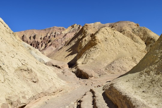
See that white layer in this hillside? That's an extremely important white layer. 680,000 years ago (give or take), a large volcanic system in what is now Wyoming erupted catastrophically, spewing ash and debris across the North American continent. You might have heard of it, it's called Yellowstone Caldera. You may notice that these pictures in no way resemble the verdant forests of the Rocky Mountains and that is because they are from Death Valley, California, located more than 620 miles (1000 km) away from the Yellowstone Caldera!

But... it gets cooler.
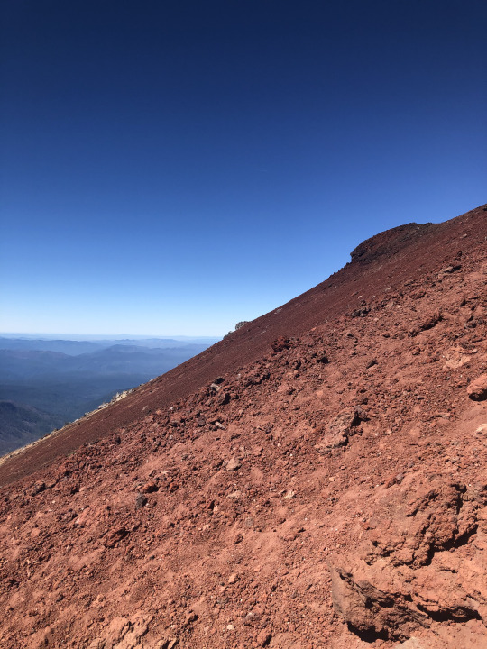
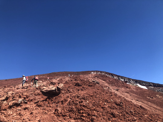
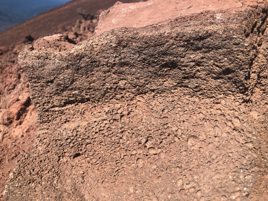
The hills this ash layer is exposed in, the Kit Fox Hills, have been uplifted. The mudstone and sediments here are ancient valley fill, meaning that they used to be the bottom of the valley and are now about 400'/120 m above the current valley floor. This is the action of the Northern Death Valley fault zone, one of California's longest active faults. In this area, that fault has some excellent outcrops as seen below.


Next door to Death Valley to the west is Panamint Valley. It's not quite as big or dramatic as Death Valley but it has many of the same sorts of geologic features which have formed over a shorter geologic timeframe, interestingly. The faults in Panamint Valley just move faster than those in Death Valley so things are a little more youthful over there. In the middle of Panamint Valley, we see this same Yellowstone ash layer but with a caveat - instead of a mere 400 feet, in Panamint Valley that ash is more than 500 feet above the valley floor! That suggests that the valley subsidence of Panamint Valley is about 20% faster than Death Valley. The true story is more complex than that, but it's good as a reference point. Let's see what that looks like.

It's hard to see in this aerial imagery, but near the top of this steep escarpment is that same volcanic ash layer. It's a bit thicker here because this big pile of material I've outlined is an ancient delta. Panamint and Death Valleys have repeatedly hosted large lakes during cooler and wetter times. This huge delta deposit is over 1.2 million years old at the base, and about 600,000 years old at the top (above the Yellowstone ash). As the Panamint Mountains (background) rose and the valley subsided, huge amounts of eroded rock and gravel were dumped on this delta. So what you're looking at is a 1 million year-long record of the floor of Panamint Valley! How cool is that?
#geology#adventures#bettergeology#rocks#delta#death valley#california desert#eastern california#california#southern california#mojave desert#death valley national park#death valley geology#geology is cool
744 notes
·
View notes
Text
Thrust system, flower structures and transpressive duplexes in Zeidun-Kareim Belt, Central Tectonic Province, Egyptian Nubian Shield (East African Orogen)

1 note
·
View note
Text
Paleo-caves in Death Valley
You have probably heard of "caves", or a natural void formed in rock. Caves are formed in a number of ways, but the most familiar are probably those formed in limestone - called karst or karstic. Karst caves are formed by the steady dissolving of limestone rock by naturally acidic groundwater percolating through the ground, often along faults or other natural weak areas.
Death Valley in California is not a hotbed of limestone caves, though evidence of them can be seen in a number of places! Ancient caves, often tens or hundreds of millions of years old, sometimes collapse or fill in with silt/minerals/debris. An ancient cave formation is called "paleokarst", and there are a few areas in Death Valley where you can find it. The easiest to access is in Titus Canyon, a major canyon who's lowest reach carves its way through limestone bedrock, leaving behind towering polished rock walls and revealing the internal structure of the rock.

Titus Canyon's narrow section is carved through the Bonanza King Formation, a Cambrian-age (538 - 485 million years ago) marine sedimentary rock package several kilometers thick. It's found in many areas of Death Valley and the surrounding region. Across its area and thickness, it alternates from dolomite to limestone (dolomite minerals versus calcite minerals). Dolomite doesn't usually dissolve and form caves, but limestone does - and the many fractures in this rock appear to have allowed numerous tiny caves to form somewhere in the distant past. Most of these have since been filled in with calcite minerals, making them paleokarst.

In this image, you can see the void of the cave lined with thinly-layered calcite. It has a flat floor, and these features are characteristic of having formed in a cave. In Titus Canyon, we can find these from a few inches to a few meters across, and as the canyon has been carved into the rock, these voids are exposed. This one below tells an exceptionally clear story:

You don't need to be a geologist to see how this differs from the first example. There's a weird pendant-shaped protrusion hanging from the top, there are layers in the minerals, the bottom half is red… there's a lot going on. Let's get some lines on there and figure out what we can see:

That's better. OK - I've separated out the parts of this outcrop which from my desk look to be distinct. Here's a close-up of part of the left-center area to show how it appears different up close.

OK, so we have the blue-gray limestone bedrock on the right, top, and lower left, then a gray-red area with layers and what looks like gravel or other angular pieces of the limestone. Above that is a finely-layered calcite deposit (remember? that's cave-like!), and above that is a layer of calcite which is rather porous. The top surface of this area is sort of scalloped and curved, which is also characteristic of limestone caves.

Here's the fully interpreted version. Let's go through the sequence of events. First, we have the limestone bedrock of the Bonanza King Formation (BKL). At some time in the distant past, a portion of it dissolved away and formed a cave. Over time, silt and debris filled in the bottom of this cave. Because it is ancient, we call it paleo-fill (OPF). This might have happened at a time when the cave was dry (not containing water), since if it was wet we would expect some amount of calcite to be deposited around its perimeter as is typical in limestone caves.
Above that is a layer of thinly-layered calcite, the cave mineral. This layer contains some reddish silt and the occasional fragment of the limestone, so the cave was probably happily active during the time that was deposited! This is the oldest cave mineralization phase I can discern in this outcrop, so I call it Old Cave Calcite (OCC).
Next, we have a slightly porous, light-colored calcite deposit. The porosity suggests to me that it was deposited faster, but I am not an expert on cave deposits so will not comment further. This unit fills the cave to its top in most places! I call this the Middle-age cave calcite (MAC).
Finally, the youngest unit is another cave-deposited calcite (YCC). As in the first cave picture above, it is a coarser-grained pale yellow color with layers that parallel the sides of the void. Most of the paleo-caves you can find in Titus Canyon are filled with this sort of calcite, and it may be geologically recent (last million years?). It filled the final remnant of this ancient paleo-cave, and is contrasting with the material around it. This visual and textural contrast is what inspired me to write this post in the first place - the best example I've seen in person of paleo-karst and the evolution of a miniature cave system, right in the heart of Death Valley - my favorite place in the world.
#geology#photography#adventures#bettergeology#california#rocks#death valley#death valley national park#cave#paleokarst#limestone#california geology#geologia#i love rocks
96 notes
·
View notes
Text
Recently got back from Death Valley, my fifth visit in the last 12 months (I think I like going there…). Not much new stuff on this visit, but I did get to see my first chuckwalla (a large lizard)! Not much as far as wildflowers go this year, they didn’t have as wet of an autumn/winter as in other recent years.
My friend the chuckwalla (Sauromalus ater):


He’s about 30 cm/1 ft long!
My friends the zebra-tailed lizards (Callisaurus draconoides):


On the left is a juvenile. Adult, on right, is about 9 cm/4 inches long excluding tail.
Here’s some geology:
Natural Bridge, the 2nd tallest but widest-spanning natural bridge in the park:

(See wife at center for scale!)
Brine pool out on the salt flats:

About 1.5 meters/5 feet wide
The ever-classic Mosaic Canyon:


Here, Precambrian Noonday Dolomite (white/yellow) metamorphosed into marble and stretched by intense pressure during mountain uplift. Later, that rock was carved into a slot canyon and filled with debris. That happened long enough ago that those debris flow deposits solidified into rock (gray, mosaic-like rock). Then, it was uplifted again and the canyon was re-carved through both the marble and the breccia!
#geology#photography#adventures#bettergeology#death valley#california#rocks#reptiles#Death Valley national park#death valley geology#slot canyon#California geology
55 notes
·
View notes
Text

As seems to happen fairly regularly, I found myself in the John Day Fossil Beds again, leading and helping out with geology hikes through the hills.


The particular topics I wanted people to get out of this hike was the relationship between rock strength and landscape shape. See the round, symmetric hill in the center of the above photo? It is made of almost unconsolidated (soft) clay and silt with very low strength. Below it is a cliff ledge of much harder rock, an ancient lahar (volcanic mudflow) which turned to concrete-like stone after flowing down an ancient river valley. This harder rock sits directly below the soft clay, holding it up.
Even in places where rocks and hills all look roughly the same, as in this part of Oregon, there is often incredible nuance to be found within the landscape.
#oregon#geology#photography#pacific northwest#adventures#bettergeology#rocks#landscapes#eastern oregon#geography#Oregon geology
80 notes
·
View notes
Text
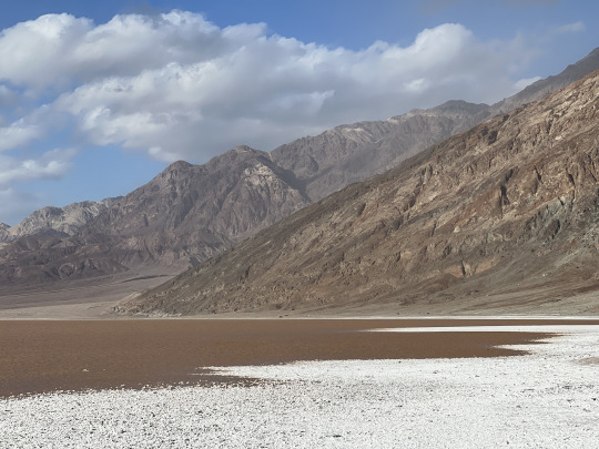

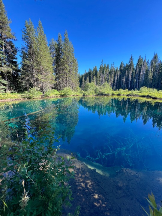
Taking a stroll in the ephemeral brines of Death Valley.
As a basin completely isolated from the sea, Death Valley is the ultimate sink and final destination for all of the surface and groundwater for an immense area of eastern California and central Nevada. Following an unusually wet summer and winter of 2023/2024, a lake as deep as 3 feet filled the salt pan on the flood of Death Valley and brought back a glimpse of how it must have looked when the valley contained a permanent lake in the geologic past.
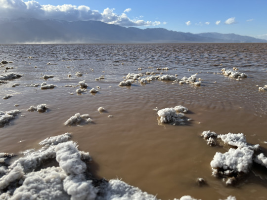
Strong winds during my last visit actually pushed the lake some two miles to the north, churning up the sediment and mud of the lake bottom and turning the water to the color and consistency of chocolate milk. As the salty water evaporates from the surrounding mud, it draws the salt into long, threadlike crystals that turn the salt flats fuzzy for a brief time.


160 notes
·
View notes
Text


I was recently on a flight to San Diego, and I flew over some of my favorite geologic structures. The cool thing about a densely populated area (Southern California) and a highly geologically active area (also Southern California) is that certain structures are large enough to be visible from the sky, even at night!
The first two pictures show the San Andreas fault, the main plate boundary between North America and the Pacific Plate. Large, fast-moving faults like the San Andreas tend to make linear valleys along their trace. These tend to be great areas to build a house, or a road, or a pipeline, or an aqueduct… because they are long, generally flat, and make pathways through the mountains. The San Andreas is paralleled with major highways, interstates, and small towns which illuminate its trace even at night.
The second two show one of my favorite faults, the Elsinore fault! It forms the east edge of the Santa Ana Mountains and also has a linear valley lined with towns (Temecula, Lake Elsinore…) and highways (Interstate 15).
#geology#bettergeology#california#earthquake#plate tectonics#san andreas#Southern California#California geology#airplane view
35 notes
·
View notes
Text


The cobble beach at Yaquina Head Area of Outstanding Natural Beauty, Oregon.
Cobble beaches are uncommon - they are a regular beach but instead of sand they are made of… well, cobbles. They require a source of hard rock, powerful waves to keep the sand from piling up, and enough time to tumble the hard rock into rounded cobbles. Yaquina Head has all three of these things! Sticking out about a half mile into the Pacific Ocean, Yaquina Head is a rocky finger of basalt about 16 million years old. It's one of the most distant outcrops of Columbia River Basalt, which flowed all the way from huge fissures in the Washington-Oregon-Idaho border area about 300 miles (500 km) to the east! At that time, this was underwater and the basalt was flowing into underwater canyons and infiltrating the soft ocean mud. This caused all sorts of strange formations within Yaquina Head, and also explains why the rock is so fractured (called brecciate in geology terms) with so much orange glassy sand in the outcrops. The powerful waves wash the orange oxidized sand (called palagonite) away, leaving behind solid hunks of basalt which slowly tumble and round out over hundreds of years.
The Pacific Ocean crashes headlong into this beach, beating the basalt with relentless power, just as it has done for over 16 million years.
#oregon#geology#pacific northwest#bettergeology#rocks#oregon geology#beach#ocean#pacific ocean#Oregon coast#newport#bureau of land management#yaquina head
44 notes
·
View notes
Text
(Lava) Bomb on the Mountain (volcano)
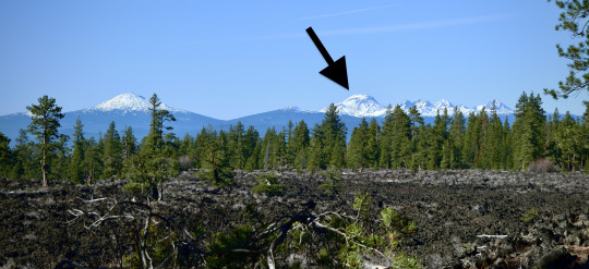
South Sister is Oregon's 3rd tallest peak. It's a stratovolcano 10,363 ft (3,158 m) tall, part of the Three Sisters complex which includes dozens of smaller volcanoes and several older eroded mountains.
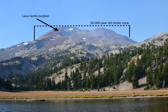
The upper 2,000 feet or so (~650 m) is a 20,000 year-old cinder cone, the result of a fire-fountain-type eruption of lava. One of the common features of that style of eruption are lava bombs - chunks of liquid lava flung through the air that cool in streamlined and elongated shapes. The upper flank of the mountain is very steep, and makes for slow climbing through cinders. Slope pitches average 30˚ in this area, and get as high as 58˚!
Perched at random on this slope is probably the largest lava bomb I've ever seen! It's probably about a meter across and shows the streamlined, elongated nature of a bomb very well. I'm not sure why it's still sitting at that precarious location, but up close you can see the vesicular texture of erupted lava (basaltic andesite). This might be classified (yes, there are sub-classifications of lava bombs - geologists love classifications!) as a breadcrust bomb because it looks almost like a crusty bread with cracked crust. These are very common on volcanoes like this. It's hard to see in this picture, but amidst the vesicles (bubbles) in the rock are numerous plagioclase feldspar crystals ~0.5-1 mm across.

Anyway, volcanoes are cool.
#oregon#geology#pacific northwest#bettergeology#rocks#volcano#three sisters#deschutes#lava#basalt#cascade volcanoes#high cascades#cascadia#pnwexplored#mountain climbing#mountains#hiking#outdoors#nature#geology is cool#adventures
228 notes
·
View notes
Text


Mementos from the Zabriskie badlands, Death Valley NP, California
What happened here? Well, I’ll tell you:
Death Valley is a huge tectonic basin. That is, it was formed by plate tectonics rather than erosion from water. It is not the first valley here, however. Valleys and basins are recorded in Death Valley’s rock record several times in the last ~25 million or so years, culminating in the current huge valley which is the deepest point below sea level in the western hemisphere. At Golden Canyon, a popular easy hiking spot, the rocks record previous editions of Death Valley. Called the Furnace Creek Formation, these soft yellow-brown rocks are made of lake sediments that were laid down when an older, smaller basin existed about 3-5 million years ago. In places, minerals in these rocks mark times when that lake dried up, recording a climate history of the area!
Less than a million years after this rock sequence was laid down, the very active faults on either side of it tore this basin apart. The rocks were folded, faulted, tilted, and uplifted to their current position by the Northern Death Valley fault and the Black Mountains faults. Slowly, the soft rocks eroded down to reveal their story, now visited by about one million people per year.
#geology#photography#adventures#bettergeology#california#death valley#love the desert#desert#Death Valley geology#Death Valley National Park#rocks#geomorphology#Pliocene
20 notes
·
View notes
Text
youtube
You’ve probably heard of the “sailing stones” in Death Valley, where the rocks apparently move across the lakebed and leave tracks behind them in the mud. Find out what makes that happen in my new video!
#geology#bettergeology#geology video#video#YouTube#death valley geology#deathvalley#Death Valley#death valley national park#sailing stones#rocks#rockposting
21 notes
·
View notes
Text

Basalt columns in basalt of Newberry Volcano, lower Crooked River Gorge, central Oregon. Each one is 60-120 cm across (2-4 feet).
#oregon#geology#photography#pacific northwest#bettergeology#rocks#oregon geology#basalt#basalt columns#central oregon
119 notes
·
View notes
Text


Ticked an item off the “visit” list a couple weeks ago: Little Crater Lake, in the Mount Hood National Forest.
It’s sort of an oddity- a near-circular straight-sloped clear blue lake in the middle of a large wetland. It seems to sit right on top of a bedrock fault, which is likely active, part of a series of extensional faults called the Oak Grove Graben (which was completely unknown until about 2020!). The thinking is that this fault allows copious amounts of groundwater to rapidly rise with enough force that it washed out this crater-shaped lake. Its similarities with real Crater Lake end there, as that lake is an enormous volcanic caldera. Nevertheless, it shares the same vertigo-inducing clarity which allows the natural deep blue of very cold water to be so striking.
We found a healthy rough-skinned newt population in the lake. I guess the cold doesn’t bother them that much! Lots of flowers were in bloom, including this lovely Western Bunchberry.
#oregon#geology#photography#pacific northwest#adventures#bettergeology#lake#newt#little crater lake#Mount hood National Forest#pnwexplored#pnwonderland
31 notes
·
View notes
Text
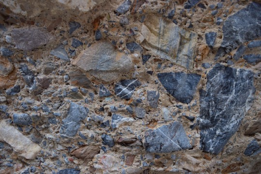
Debris-flow breccia, Mosaic Canyon, Seath Valley National Park, California, USA.
#geology#photography#california#bettergeology#rocks#death valley geology#death valley national park#california geology
57 notes
·
View notes
Text


Mosaic Canyon at dusk, Death Valley National Park, CA.
August 2024.
Flickr
17 notes
·
View notes
Text
youtube
Much of western Washington's recent geology has been dominated by giant ice sheets stretching from the Canadian Rockies to central Washington. This ice gouged out the Salish Sea, Puget Sound, and carved up the rest of the landscape. Port Townsend sits on a peninsula made up of the junk giant glaciers left behind. This is typically sandstone, gravel, and mud but weird stuff starts happening when the giant glacier meets the ocean and starts to melt. There's lots of cool geology in Port Townsend, once you know where to look!
#BetterGeology#geology#geology video#science video#science#earth science#nature video#video#youtube#glacier#washington geology#Glacier#glaciology#ice age#cordillera#olympic peninsula#port townsend#PNW#Pacific Northwest#Youtube
67 notes
·
View notes