#@structuralgeology
Explore tagged Tumblr posts
Text
Thrust system, flower structures and transpressive duplexes in Zeidun-Kareim Belt, Central Tectonic Province, Egyptian Nubian Shield (East African Orogen)

1 note
·
View note
Text

Source: LEARN Geology
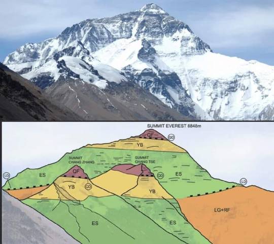
𝗠𝗮𝗿𝗶𝗻𝗲 𝗟𝗶𝗺𝗲𝘀𝘁𝗼𝗻𝗲: 𝗧𝗵𝗲 𝗛𝗶𝗴𝗵𝗲𝘀𝘁 𝗥𝗼𝗰𝗸𝘀 𝗶𝗻 𝘁𝗵𝗲 𝗣𝗹𝗮𝗻𝗲𝘁
Everest Range, 𝗡𝗲𝗽𝗮𝗹 and 𝗧𝗶𝗯𝗲𝘁, 𝗖𝗵𝗶𝗻a 27°59'17"N / 086°55'30"E
𝙂𝙚𝙤𝙡𝙤𝙜𝙞𝙘𝙖𝙡 𝙋𝙚𝙧𝙞𝙤𝙙:
Middle 𝗢𝗿𝗱𝗼𝘃𝗶𝗰𝗶𝗮𝗻 (𝗗𝗮𝗿𝗿𝗶𝘄𝗶𝗹𝗶𝗮𝗻)
𝘿𝙚𝙨𝙘𝙧𝙞𝙥𝙩𝙞𝙤𝙣: Mount Everest is 𝗘𝗮𝗿𝘁𝗵'𝘀 𝗵𝗶𝗴𝗵𝗲𝘀𝘁 𝗺𝗼𝘂𝗻𝘁𝗮𝗶𝗻 above sea level, located in the Mahalangur Himal sub-range of the Himalayas. The China–Nepal border runs across its summit point. Its elevation of 𝟴,𝟴𝟰𝟴.𝟴𝟲 𝗺 was most recently established in 2020 by the Chinese and Nepali authorities.
𝗚𝗲𝗼𝗹𝗼𝗴𝗶𝗰𝗮𝗹 𝗗𝗲𝘀𝗰𝗿𝗶𝗽𝘁𝗶𝗼𝗻:
The 𝘀𝘂𝗺𝗺𝗶𝘁 of Mount Everest, the 𝗵𝗶𝗴𝗵𝗲𝘀𝘁 𝗽𝗼𝗶𝗻𝘁 on Earth, was a 𝘀𝗲𝗮 ��𝗹𝗼𝗼𝗿 once. 𝗜𝘀𝗻'𝘁 𝘄𝗼𝗻𝗱𝗲𝗿𝗳𝘂𝗹?. The highest rock on Earth, marking the summit of Mount Everest, are 𝗢𝗿𝗱𝗼𝘃𝗶𝗰𝗶𝗮𝗻 𝗟𝗶𝗺𝗲𝘀𝘁𝗼𝗻𝗲𝘀, deposited in a warm, shallow water sea some 𝟰𝟱𝟬 𝗠𝗮 𝗮𝗴𝗼.
These rocks deposited in an 𝗮𝗻𝗰𝗶𝗲𝗻𝘁 𝗧𝗲𝘁𝗵𝘆𝗮𝗻 𝗢𝗰𝗲𝗮𝗻 were thrust and 𝘂𝗽𝗹𝗶𝗳𝘁𝗲𝗱 into their present commanding position when 𝗜𝗻𝗱𝗶𝗮𝗻 𝗽𝗹𝗮𝘁𝗲 𝗰𝗼𝗹𝗹𝗶𝗱𝗲𝗱 with the 𝗔𝘀𝗶𝗮𝗻 𝗰𝗼𝗻𝘁𝗶𝗻𝗲𝗻𝘁 some 𝟱𝟱 𝗺𝗶𝗹𝗹𝗶𝗼𝗻 𝘆𝗲𝗮𝗿𝘀 𝗮𝗴𝗼.

𝗤𝗙: 𝗤𝗼𝗺𝗼𝗹𝗮𝗻𝗴𝗺𝗮 𝗙𝗼𝗿𝗺𝗮𝘁𝗶𝗼𝗻 (𝗘𝘃𝗲𝗿𝗲𝘀𝘁 𝗹𝗶𝗺𝗲𝘀𝘁𝗼𝗻𝗲𝘀): It is the un-metamorphosed layer of limestone here called ‘QF’ for 𝗤𝗼𝗺𝗼𝗹𝗮𝗻𝗴𝗺𝗮 𝗙𝗼𝗿𝗺𝗮𝘁𝗶𝗼𝗻, which forms the 𝘀𝘂𝗺𝗺𝗶𝘁 of Everest. It is separated from the underlying Yellow Band layer by a low angle detachment fault.
𝗬𝗕:𝗬𝗲𝗹𝗹𝗼𝘄 𝗕𝗮𝗻𝗱: This is the layered bedding. It is a limestone, formed from a shallow marine sediment, heated to become a 𝗺𝗮𝗿𝗯𝗹𝗲.
𝗘𝗦: 𝗘𝘃𝗲𝗿𝗲𝘀𝘁 𝗦𝗲𝗿𝗶𝗲𝘀: It consists of 𝘀𝗲𝗱𝗶𝗺𝗲𝗻𝘁𝗮𝗿𝘆 rock which has been metamorphosed at reasonably high temperatures. It is separated from the underlying layer by a low angle almost horizontal fault.
𝗥𝗙: 𝗥𝘂𝗻𝗴𝗯𝗼𝗸 𝗳𝗼𝗿𝗺𝗮𝘁𝗶𝗼𝗻: The Rungbok Formation consists of ‘LG’ Leuco- granite and gneiss.RF is a gneiss: rock partly melted and metamorphosed under high temperatures.
𝙁𝙤𝙨𝙨𝙞𝙡𝙨:
These rocks still contain the fossils of marine animals such as 𝗕𝗿𝗮𝗰𝗵𝗶𝗼𝗽𝗼𝗱𝘀, 𝗖𝗼𝗻𝗼𝗱𝗼𝗻𝘁𝘀 and 𝗖𝗿𝗶𝗻𝗼𝗶𝗱𝘀 that occupied tropical habitats during one of the most 𝗶𝗺𝗽𝗼𝗿𝘁𝗮𝗻𝘁 𝗶𝗻𝘁𝗲𝗿𝘃𝗮𝗹𝘀𝗹𝘀 in 𝗘𝗮𝗿𝘁𝗵'𝘀 history, the 𝗚𝗿𝗲𝗮𝘁 𝗢𝗿𝗱𝗼𝘃𝗶𝗰𝗶𝗮𝗻 𝗕𝗶𝗼𝗱𝗶𝘃𝗲𝗿𝘀𝗶𝗳𝗶𝗰𝗮𝘁𝗶𝗼𝗻 𝗘𝘃𝗲𝗻𝘁 (𝗚𝗢𝗕𝗘).
#himalayan#mounteverest#ordovician#limestone#nepal#india#tibet#indianplate#eurasianplate#geology#thrust#stratigraphy#sedimentology#petrology#structuralgeology#tethys#earthscience#iugs#unesco#geoheritage#knowledge
34 notes
·
View notes
Photo

Sorry I’ve been so absent lately... stuff went down on this trip that made me lose a little faith in the people I study with plus I’m a busy human. I don’t remember where this was (it was someones backyard) but this was the first stop of the second trip of the semester! I had so much fun learning about structural geology in the wild. According to my professor this is one of the best outcrops of a syncline in the world. Unlcear if he was just bragging but a 5′3″ me for scale :)
#geology#justgeologythings#structuralgeology#rocks#minerals#fieldtrips#this photo was taken on friday september 13th#happy spoopy szn#halloween day one
54 notes
·
View notes
Photo

Hi everyone I’m back here’s the outcrop I mapped my last day of junior year.
9 notes
·
View notes
Photo

1 note
·
View note
Photo

Dusong Peninsula: A geological heritage site @Saha-gu, Busan . Busan is the 2nd largest city of Korea that holds various natural scenes of ocean, mountains, and estuaries. There are also 12 unique geological heritage sites in the city designated by Busan National Geopark. Dusong Peninsula is one of them where the steep slopes and rocky shores represent the ancient environment of Busan in the late cretaceous period i.e. the dinosaur era. It is believed that the strong earthquake shook this paradise of dinosaurs. Distinct geological structures such as geological unconformities, faults, clastic dykes, andesitic sill, calcrete deposits can be seen here. It is also mentioned on the information board that dinosaurs nest and egg fossils, petrified woods can be seen here which can be very interesting to those who loves geology. #geopark #geology #geologyrocks #geologyporn #structuralgeology #geologywonders #geologyeverywhere #geologylove #geologytrip #koreabyme #koreatourism #dadaepo #busancity #visitbusan #busantrip #travel #travelphotography #naturephotography #beautifuldestinations #landscape #instatravel #nature_brilliance #hiking #사하구 #아름다운부산 #부산여행 #두송반도전망대 #두송반도 #대한민국구석구석 #국내여행 . https://www.instagram.com/p/CMP30hRMBNp/?igshid=eni5iyn7pq62
#geopark#geology#geologyrocks#geologyporn#structuralgeology#geologywonders#geologyeverywhere#geologylove#geologytrip#koreabyme#koreatourism#dadaepo#busancity#visitbusan#busantrip#travel#travelphotography#naturephotography#beautifuldestinations#landscape#instatravel#nature_brilliance#hiking#사하구#아름다운부산#부산여행#두송반도전망대#두송반도#대한민국구석구석#국내여행
0 notes
Photo

Amazing Landscape 😲 📸@sebastianmzh . . #geologist #geology #geologyrocks #geologia #minerals #rocks #geologypage #a #geologists #geological #fossil #geo #nature #mineral #science #petroleum #structuralgeology #fossils #earth #geolog #crystals #geologystudent #geomorphology #mining #ingenier #petrology #geologiaestructural #ammonites #explore #geologykarur (at North Bend, Oregon) https://www.instagram.com/p/CKQgefjFyJq/?igshid=s4xv6j4yut2l
#geologist#geology#geologyrocks#geologia#minerals#rocks#geologypage#a#geologists#geological#fossil#geo#nature#mineral#science#petroleum#structuralgeology#fossils#earth#geolog#crystals#geologystudent#geomorphology#mining#ingenier#petrology#geologiaestructural#ammonites#explore#geologykarur
0 notes
Photo

Source: GEOLOGY ART. INTRUSIONS
More intrusion themed illustrations there: https://strike-dip.com/geology-art-intrusions/
I know somebody would like it as their new desktop image or as new picture hanging on the wall, so I made them available as digital files (mostly in 4k): https://www.artstation.com/linajakait/store
Some of the illustrations are also available as prints:https://www.artstation.com/linajakait/prints
#geology#3D design#geology art#blender#structuralgeology#Sill#knowledge#I'm having trouble understanding and imagining the structural geology subjects thank you very much.
2 notes
·
View notes
Video
instagram
Sharp halite crystals from Sieroszowice mine in Poland. Color is caused by the presence of organic inclusions. @examinearth . . . . . . . . . . #geologist #geology #geologyrocks #geological #rocks #minerals #geologia #geologypage #geologists #geomorphology #structuralgeology #geo #crystals #nature #geologystudent #geologiaestructural #fossil #mineral #petroleum #fossils #mining #photography #earth #science #halite #crystalsforsale #infinitystones #examinearth https://www.instagram.com/p/CCqK65IHReZ/?igshid=tzej4b9i3wum
#geologist#geology#geologyrocks#geological#rocks#minerals#geologia#geologypage#geologists#geomorphology#structuralgeology#geo#crystals#nature#geologystudent#geologiaestructural#fossil#mineral#petroleum#fossils#mining#photography#earth#science#halite#crystalsforsale#infinitystones#examinearth
9 notes
·
View notes
Photo

The rolling hills of Tuscany! 🌿🏔😍 . Follow @paradisetravels99 👈 . credit: @ilhan1077 . . #geologist #geology #geologyrocks #geologia #minerals #rocks #geologypage #a #geologists #geological #fossil #geo #nature #mineral #science #petroleum #structuralgeology #fossils #earth #geolog #crystals #geologystudent #geomorphology #mining #ingenier #petrology #geologiaestructural #paradisetravels99 #ammonites #paleontology (at Tuscany, Italy) https://www.instagram.com/p/CIiGcEDj1O9/?igshid=1m48d398r2zc
#geologist#geology#geologyrocks#geologia#minerals#rocks#geologypage#a#geologists#geological#fossil#geo#nature#mineral#science#petroleum#structuralgeology#fossils#earth#geolog#crystals#geologystudent#geomorphology#mining#ingenier#petrology#geologiaestructural#paradisetravels99#ammonites#paleontology
0 notes
Photo

JAM 2020 GEOLOGY QUESTION SOLVED NAT (Q51-Q60). PART-05... Many more to come. R u ready??.... #NAT #NUMERICALINGEOLOGY #GeologyNumerical #JAM #JAMGEOLOGY #IIT #MSC #MSCTECH #GEOLOGY #GEOPHYSICS #2020 #PALEONTOLOGY #STRATIGRAPHY #STRUCTURALGEOLOGY (at India) https://www.instagram.com/p/CHAh8GkHMIU/?igshid=ukt5lwldosm0
#nat#numericalingeology#geologynumerical#jam#jamgeology#iit#msc#msctech#geology#geophysics#2020#paleontology#stratigraphy#structuralgeology
0 notes
Photo

What Pangea Would Look Like With Our Current International Borders and visible continents. ▫️ The map above shows Pangaea, a supercontinent that existed from 300 million to 175 million years ago, with modern international borders. . ▫️ In a day and age where borders are constantly on our mind, just who would have been our neighbors—and how would the world be different—if Pangea existed today? . ▫️ It’s a question Massimo Pietrobon had on his mind when he created Pangea Politica, a conceptual map demonstrating where modern countries would fall within Pangea if it still existed today. . ▫️ In Pietrobon’s world, the United States cuddles up to Russia, while Africa dominates the map. Neighboring North America, South America, Antarctica, Europe, and the Middle East, Africa’s imposing stature reminds us of just how large the continent really is. . ▫️ While the designer notes that the scale of some countries could be better—see this true size map to verify dimensions—for him, it is the concept that counts. . ▫️ Where do you think we’d be today if Pangea had stayed together? . ▫️ #earth #earthscience #geology #geologyrocks #unb #unbfredericton #sciences #geoscience #rocks #mineral #sedimentary #metamorphic #structuralgeology #tectonic #petrology #research #miner #fieldgeology #continentaldrift #tectonicplates #pangea https://www.instagram.com/p/B5RpT1Envq3/?igshid=18ogn9wxlm6nk
#earth#earthscience#geology#geologyrocks#unb#unbfredericton#sciences#geoscience#rocks#mineral#sedimentary#metamorphic#structuralgeology#tectonic#petrology#research#miner#fieldgeology#continentaldrift#tectonicplates#pangea
0 notes
Photo

A Wish Before Midnight . . . . . Across an amethystine night sky, the fleeting arcs of shooting stars form incandescent traces. Their distorted echoes mirrored by our thoughts, influence our desire to make a wish. [] The Doomsday Clock was originally intended to show how close we are to nuclear catastrophe. Nowadays it is also used to show how close we are to a climate catastrophe. It is currently set at one hundred seconds before midnight. Many believe we’ve already past that point. [] Biodiversity is essential for the processes that support all life on Earth. However, in a list of threats to biodiversity, climate change ranks fifth. The change in our use of land and the oceans is ranked number one. It is followed by species overexploitation, the global spread of invasive species and disease, and pollution. These threats are a consequence of how we treat the world. Their impact can be reduced by changing how we consume resources, produce food, by genuinly restricting urban sprawl, and improving how we interact with Nature [] Each and every one of us can make a difference by confronting complacency, acting locally, and going beyond good intentions and wishes. [] Borrowing from the Dalai Lama “We can't help the planet just by making a wish, to do so we have to take action.” [] Another digitally metamorphosed ICM image. [] No rocks were harmed in the creation of this image. Well, some were indirectly [] Poem and photo created by Andy Abraham [] #abstractlovers #abstract photography #affinitybyserif #camerapainting #creativephotography #digitalart #earthinspiredart #ecopoetry #environmental #environmentalart #environmentaljustice #environmentalpoetry #geologymeetsart #geopoetics #icm_community #nature #naturephotography #photooftheday #poetry #rocks #southgeorgianbay #science #structuralgeology #sustainability #unique [] Discover your connectivity with the natural world around you [] @artisticrocktextures [] Visualizing our affinity with nature [] ©️ArtisticRockTextures [] Andy Abraham2022 [] Toronto, Canada [] All rights reserved [] DM for repost permissions (at Toronto, Canada) https://www.instagram.com/p/CdyGTEKOlLj/?igshid=NGJjMDIxMWI=
#abstractlovers#abstract#affinitybyserif#camerapainting#creativephotography#digitalart#earthinspiredart#ecopoetry#environmental#environmentalart#environmentaljustice#environmentalpoetry#geologymeetsart#geopoetics#icm_community#nature#naturephotography#photooftheday#poetry#rocks#southgeorgianbay#science#structuralgeology#sustainability#unique
2 notes
·
View notes
Photo

Today we focused on the oceanic #sediments of the Hawasina group that were also thrust onto Arabia with the Semail #ophiolite In the morning (photos 10 and 9) we visited a fossil white smoker distinguished from the black smoker from yesterday by the large amount of opal found at the site. We then moved on to the site of a 1000 year old copper mine that had pillow basalts, dikes and columnar cooling joints to be seen. We then crossed off the Semail Ophiolite nappe and on the the Hawasina nappe. Where the hot Semail nappe thrusted over the Hawasina nappe an 'ironing' effect occurred, metamorphoseing the rocks along the thrust fault. This is called the #metamorphic sole. We stopped to examine rocks in the metamorphic sole (photo 8). We then moved into the spectacularly folded Hawasina sediments. These sediments were lain down in deep water conditions but were still partially made of turbidite flows. The highlight of the sediments were the amazing mullions observed in photo 1. #geology #geotourism #oman #structuralgeology (at Oman) https://www.instagram.com/p/BuJa6PhA2GQ/?utm_source=ig_tumblr_share&igshid=1rlw3zwb2gpi8
0 notes
Photo

Zinc Silicate CoatingIt is used as a single coat system or priming coat for heavy duty systems for: Structural Steel, Pipelines, interior and exterior of storage tanks for Fertilizer plants, Refineries & Petrochemical units, Chemical units, Offshore Platforms, Power Plants etc.#coatings #detailing #coating #ceramiccoating #paint #paintcorrection #concrete #construction #industrial #ceramic #corrosion #trucks #floordesign #detailingboost #garagefloor #polishing #engineering #cardetailing #garagegoals #powdercoating #polishedconcrete #headlightrestoration #wash #technology #midstream #petrol #offshorelife #drill #drillingrigs #petrochemical #india #refinery #geological #geologyrocks #energyindustry #structuralgeology #oilrig #geomorphology #halliburton #petroleo #geologiaestructural #conservation #geologistsFor more details Please visit https://czarlab.com/ or call or whatsapp to 9845002444
1 note
·
View note
Video
tumblr
👇Menciona el tipo de lava que se forma 🌋 📹: @epiclava_ . . . . #geology #geologyrocks #geologymemes #structuralgeology #geologynerd #geologylife #geologyporn #geologyaddicts #geologyart #geologyadventures #geologyclass #geologylove #geologylover #geologyrock #ilovegeology #geologyfieldtrip #geologystudent #geologyscience #igeologia #travel #explorar #photography #explore #viajar #nature #naturaleza #naturalezaviva #adventure #travelling #aventura
15 notes
·
View notes