#geomorphology
Explore tagged Tumblr posts
Visit Tumblr Blog
Explore Tumblr blogs with no restrictions, modern design and the best experience.
Last Seen Tumblr Blogs


Fun Fact
Tumblr has 4 main sources of revenue.
Text


Faraway views (right lens of my binoculars)
#pursuit 8x42mm if anyone is curious…#observations#mine#my photography#nature#ocean#newfoundland#island#atlantic ocean#canada#binoculars#film photography#ecology#geomorphology
46K notes
·
View notes
Text

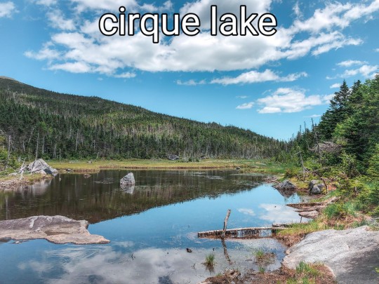
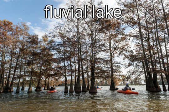

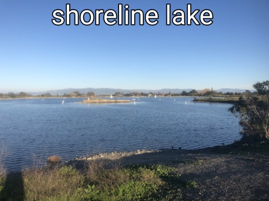
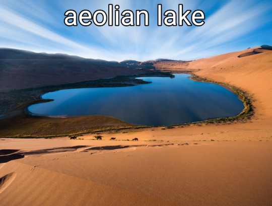
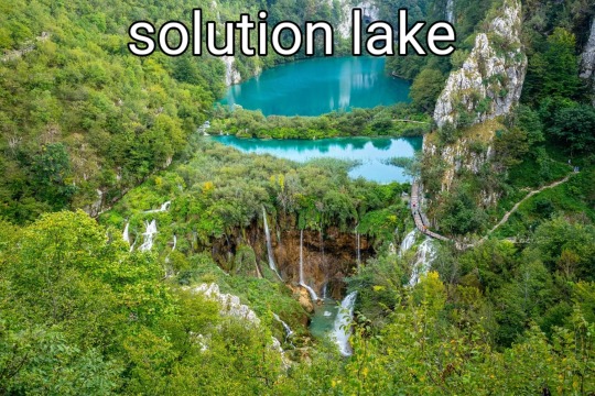


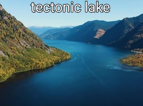
#lakes#lakeposting#poll#geology#geomorphology#nature#lake#naturecore#beautiful#limnology#science#ecology#aquatic ecology#water#meteor#meteorite#volcanic#glacier#glacial#tectonic#earth#environment#environmental science
2K notes
·
View notes
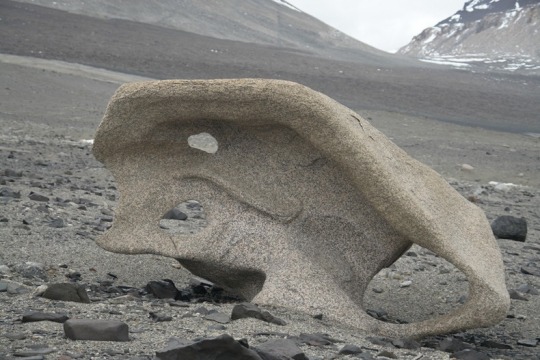
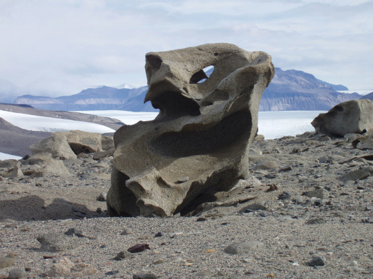
Text


Went on my first geomorph lab. Here are awesome examples of honeycomb weathering and natural pillars. I thoroughly enjoyed it !
73 notes
·
View notes
Text

Moon, City and Organ Mountains at Sunset, by MelvinL.
Las Cruces, New Mexico.
32 notes
·
View notes
Text


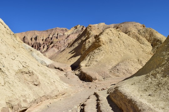

Mementos from the Zabriskie badlands, Death Valley NP, California
What happened here? Well, I’ll tell you:
Death Valley is a huge tectonic basin. That is, it was formed by plate tectonics rather than erosion from water. It is not the first valley here, however. Valleys and basins are recorded in Death Valley’s rock record several times in the last ~25 million or so years, culminating in the current huge valley which is the deepest point below sea level in the western hemisphere. At Golden Canyon, a popular easy hiking spot, the rocks record previous editions of Death Valley. Called the Furnace Creek Formation, these soft yellow-brown rocks are made of lake sediments that were laid down when an older, smaller basin existed about 3-5 million years ago. In places, minerals in these rocks mark times when that lake dried up, recording a climate history of the area!
Less than a million years after this rock sequence was laid down, the very active faults on either side of it tore this basin apart. The rocks were folded, faulted, tilted, and uplifted to their current position by the Northern Death Valley fault and the Black Mountains faults. Slowly, the soft rocks eroded down to reveal their story, now visited by about one million people per year.
#geology#photography#adventures#bettergeology#california#death valley#love the desert#desert#Death Valley geology#Death Valley National Park#rocks#geomorphology#Pliocene
20 notes
·
View notes
Note
do i.. WANT to know about the drumlins?
YES YOU DO
Drumlins are glacial landforms, which means you find them only in places that have been glaciated. And they're very distinct when you know what you're looking for.
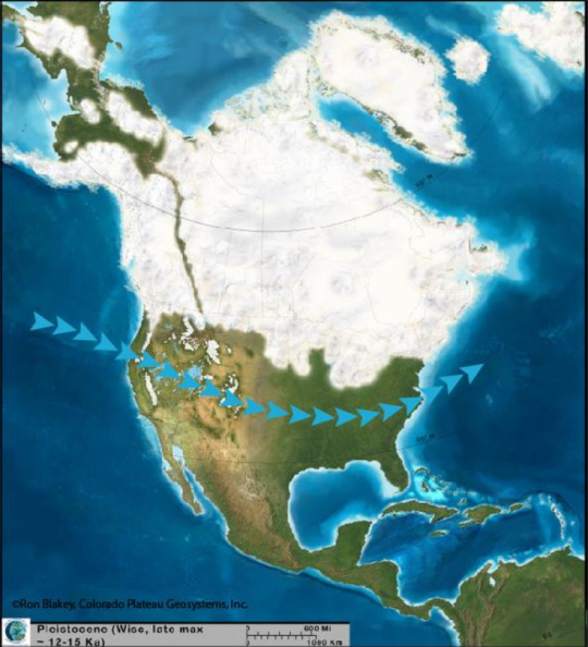
A hill with one steep side, one looooong sloping side, and you've (most likely) got yourself a drumlin. (Unless it's small. Drumlins are tens of meters high and hundreds of meters long, so if you've got a short one with way more elongation, you've got a drumlinoid.) They're all over Canada,the north eastern US, and northern Europe. The one pictured above is in Ireland. The ones in Canada and the US formed as the Laurentide Ice Sheet, a kilometers thick mass of glacial ice, was spreading across North America during the Last Glacial Maximum
There are lots of really cool glacial landforms (eskers and kames and lakes (Glacial Lake Agassiz my beloved) and like a dozen types of moraine), but drumlins are my favourite because they're so incredibly easy to identify, they occur in swarms, and they're kinda weird as hell
There's still some debate among geomorphologists about how, exactly, they form but I was told that the (mindbogglingly huge mass of) ice catches on a sticky uppy bit of bedrock and instead of mowing it down like a child kicking over a stack of blocks, moves around it instead. And because there's now a place behind the bedrock where there's less ice, the ice drops a whole bunch of glacial till (all the bits of sediment that did get mowed down like a child kicking over a stack of blocks) on the other side of the bedrock bit

(This is a constructional theory, where the drumlin is built up. the other main one is the erosional theory, where everything but the drumlin is eroded. There's also a theory that drumlins are deposited by subglacial meltwater, but that one is highly controversial)
"Now wait," I hear you say, "go back a bit. What the fuck was that about swarms?"
They occur in swarms.

If you've got one drumlin, good chances you've got a lot of drumlins. Which is actually amazing, because the steep side of the drumlin faces the direction of flow, which means we know exactly how the ice sheet moved. In this image, for example, the ice started at the top, near Lake Ontario, and then moved south. From looking at drumlins (and other glacial landforms, we do like to have multiple reference points), we know that the Laurentide Ice Sheet started in the Hudson Bay and crept out from there
And because they're so distinct (tear drop shaped, made of till, occur in swarms), and because drumlins can only have been made by glacial activity, we can look all over the world and find these things and know that this place was once under several thousand tonnes of ice

Not during the Last Glacial Maximum, but definitely ones before it. And I just think that's neat
#'glacial till' I say as if all till isn't glacial#that's only in there for the non-geologists tbh#I love drumlins so much#they're neat#rocks#long post#Loxie has words#geology#geomorphology#These thing can be made of some weird things too#Here in Alberta we're on carbonate rock#because of that ocean that used to be here before BC crashed into us#but we've got granite in our till deposits#which was imported here by the glacier express from Ontario#where the Canadian Shield is exposed#the Shield which is made of granite and other igneous rocks#(we've got granite too but it's buried *deep* beneath the carbonate)
244 notes
·
View notes
Text

this massive fault in Spain's Central System is gorgeous and underdiscussed. They even have a road running through the middle...

24 notes
·
View notes
Text

Cirques, Central Colorado Rockies from IAD-LAX Flight, 2023.
The evidence for extensive glaciation is ample in the Colorado Rockies.
#landscape#aerial photos#geomorphology#glaciology#rocky mountains#colorado#2023#photographers on tumblr#black and white
27 notes
·
View notes
Text
Science Science-Fiction Movies
Not all scientists are physicists! Here are some movies that highlight different fields of study
All fully recommended, some of my personal favorites
Geomorphology and Geophysics: The Core

Geomorphology: the scientific study of the physical and chemical processes that impact how surface of a planet changes. For example, a fluvial geomorphologist is a scientist that studies how rivers (fluvial) change the surface of a planet. Not always Earth, some geomorphologist study planets like Mars and Mercury. Earth science is more than just geology and rocks! Sometimes it also about rocks moving around or being eroded 🌏
Meteorology: Twister and Twisters


Meteorology: the study of a planet’s atmosphere with a strong focus on forecasting the weather 🌪️
Linguistics: The Arrival
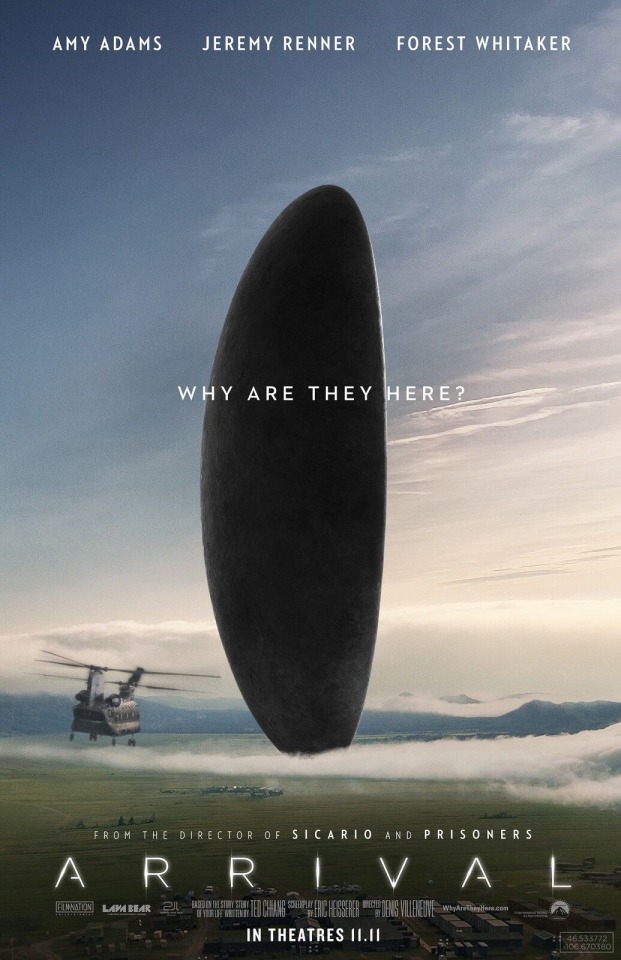
Linguistics: the scientific study of languages 🖋️
Seismology: Tremors
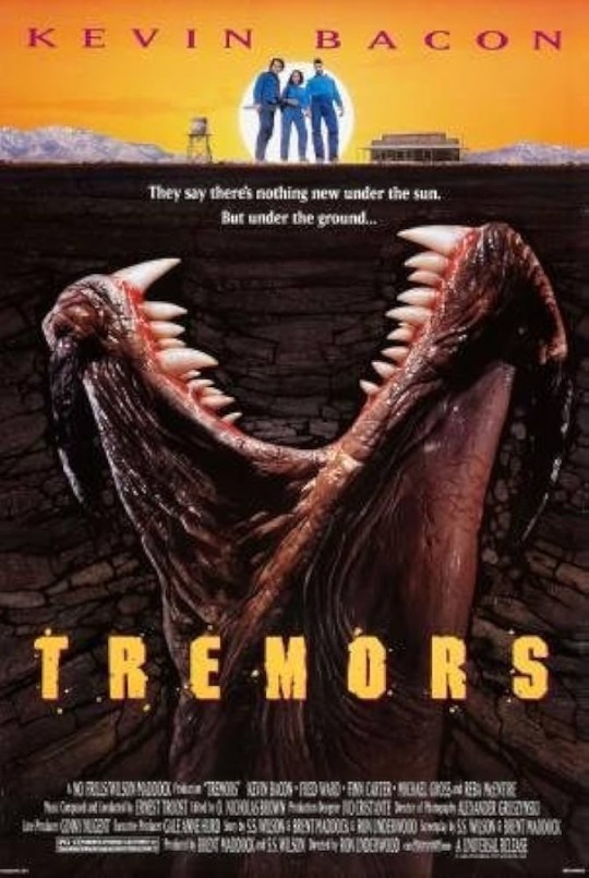
Seismology: the scientific study of earthquakes 🪇🪨
Heliophysics and Solar Physics: Sunshine

Heliophysics: the scientific study of the sun and its effects on the solar system ☀️
Paleontology: Jurassic Park
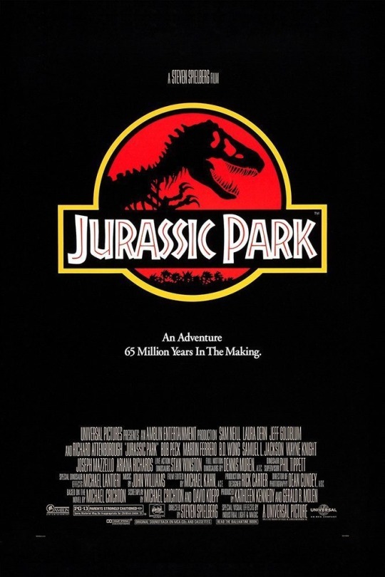
Paleontology: the scientific study of life on earth through the fossil record 🦴 🦕
Botany and Astrophysics: The Martian

This one is a bit of a mix. The book makes uses of a lot of astrophysics, but the character is a botanist
Astrophysics: the scientific study of physical and chemical processes of the cosmos (a newer field of astronomy that includes more of a focus on physics) 🛰️
Botany: the scientific study of plants 🌱
Genetics and Astronomy: Gattaca

Another mix! The main theme of the movie revolves around genetics and genetic engineering (specifically eugenics). However, the main character is an astronomer/astronaut
Genetics: a branch of biology that concerns the scientific study of genes, genetic variation, and heredity 🧬
Astronomy: the study of space, stars, planets, and other celestial objects 🪐
#the core#twister#twisters#arrival#tremors#sunshine#movie recommendation#science fiction#science fiction movies#geomorphology#geophysics#meteorology#linguistics#Seismology#heliophysics#botany#the martian#jurassic park#paleontology#gattaca#genetics#astronomy
22 notes
·
View notes
Text
Geomorphology is the study of the form of the earth. Coastal geomorphologists study the way that the coastal zone, one of the most dynamic and changeable parts of the earth, evolves, including its profile, plan-form, and the architecture of foreshore, backshore, and nearshore rock and sediment bodies. To understand these it is necessary to examine wave processes and current action, but it may also involve drainage basins that feed to the coast, and the shallow continental shelves which modify oceanographic processes before they impinge upon the shore. Morphodynamics, study of the mutual co-adjustment of form and process, leads to development of conceptual, physical, mathematical, and simulation models, which may help explain the changes that are experienced on the coast.
C. Woodroffe, Geomorphology, in Encyclopedia of Ocean Sciences, 2001
#quote#geology#geomorphology#nature#science#Colin David Woodroffe#Colin Woodroffe#coastal science#morphodynamics
14 notes
·
View notes
Text
A new ocean is slowly forming in Africa due to a 35-mile crack that appeared in Ethiopia in 2005. This crack is caused by three tectonic plates—the Nubian, Somali, and Arabian plates—gradually pulling apart. Scientists estimate it will take 5 to 10 million years for the ocean to fully form.
The Afar region, where the plates meet, is a unique place to study tectonic processes. Some researchers believe the rift is driven by a massive plume of superheated rock rising from the Earth’s mantle beneath East Africa. The plates are moving at different speeds, with the Arabian plate drifting away from Africa at about 1 inch per year and the African plates separating even slower, between 0.2 to 0.5 inches annually.
Eventually, this process will create a new mid-ocean ridge system, paving the way for a new ocean to emerge in Africa.

5 notes
·
View notes
Text
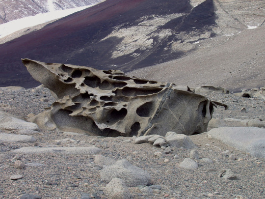
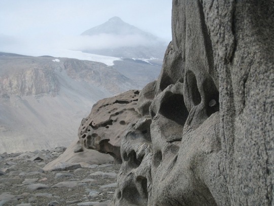

The aeolian processes of katabatic winds in Antarctica’s McMurdo Dry Valleys shape boulders into surreal formations
#ultimate life goal is to visit here#antarctica#mcmurdo station#mcmurdo dry valleys#desert#geomorphology#geology#rocks#aeolian processes#aeolian landform#earth science
5K notes
·
View notes
Text
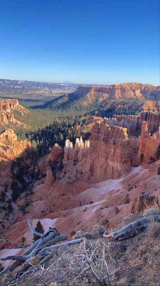
Bryce hike!
#mine#travel#nature#life#photography#scenic#hike#adventure#national parks#utah#bryce canyon#geomorphology#earth#landscape
38 notes
·
View notes
Text
Quaternary Geomorphology
I became a surficial mapper this summer, following the step-cuts of proglacial shorelines across farm fields and verdant aspen stands, until the ghost of water took form. There lies the joy of geomorphology, vivid and visible, screaming out a story once you learn how to look for its traces.
I think love leaves traces.
This fall, I am taking dance lessons in the basement of my students' union. My instructor has the same cupid's bow smile of someone I once kissed, who talked me through the top surgery referral process one spring-green evening. I am wearing hand-me-down flannel from a friend half a continent away. Oh, friendly ghosts, hello -- I dance with a girl with field-rough hands and recognize the heat blooming beneath my ribs as my constant. We are caught in the process of becoming, all. Nothing, love nor learning, is ever wasted. It is only transformed, lakeshore clay to loam.
Look, you can see it still.
4 notes
·
View notes
Photo

Flame Azalea flashing their bright orange coloring against a lush green backdrop of North Carolina mountains underneath a blue sky of building clouds. Roan Highlands, Southern Appalachian Mountains. Carter, Tennessee. Photo by Mark van Dyke.
239 notes
·
View notes
Text
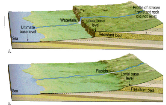
Knickpoints, base level, and waterfalls
I won't go into detail about hydraulics, but hi! Let's talk about rivers a little!
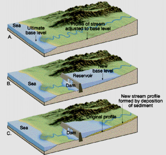
Base level: in geomorphology, the "base level" is the lowest point at which erosion can occur, or in the case of rivers, it's the lowest altitude at which a river can flow. A common base level for most rivers is the sea, though for some of them it might be a lake, a different river that the first river is a tributary to, or a dam.
The base level for any given river can change through time, since sea levels can vary, dams can be built, etc. A variation in base level, causes a variation in the river's energy, which can lead to more erosion, or more sediment deposition depending on if the river has more or less energy than before.
Here are two examples, the first is of a river whose base level dropped lower, it gained more energy and started eroding the substrate more, the second one is of a river whose base level was raised higher, and it started depositing more sediment to compensare with lowered energy.
This was an introduction to explain the concept of base level, now let's move on to knickpoints.
Knickpoint: a sudden and sharp variation of a river's slope, often leading to the formation of waterfalls and/or lakes. Some reasons why a knickpoint might form are: base level drop, tectonic activity, or a later of erosionally resistant rock:

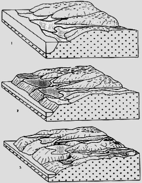
There are generally two types of knickpoints: migrating and fixed.
Migrating knickpoints are mainly caused by base level drop and tectonic activity. They are called migrating because due to the erosion that the river applies on the substrate, the knickpoint is able to travel upstream. In the case of a base level drop type of knickpoint that affects an entire hydrography basins, usually the baisin will have all of its migrating knickpoints at the same altitude:

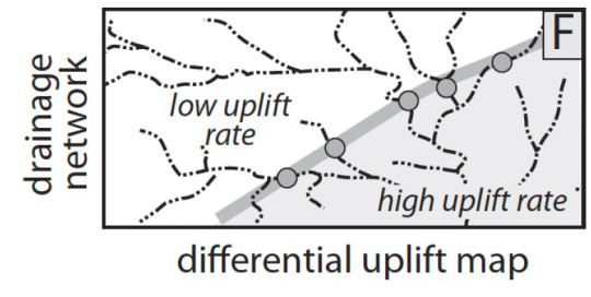
Sometimes, knickpoints are caused by differential uplift (two areas within a hydrographic basin are subject to different rates of tectonic uplift), and this causes a "barrier" of knickpoints that can easily be drawn within the baisin:
Fixed knickpoints instead are caused mostly by the presence of a layer of erosionally resistant rock, as it is something that the river cannot easily erode through, and will remain fixed.

Waterfalls can form from any of these kinds of knickpoints, it really depends on the river's erosion ability, it's energy, it's mass flow rate, the kind of sediments it carries, etc.
#geomorphology#original post#geology#this one was kinda dumb lol sorry but this exact topic kicked my ass yesterday
45 notes
·
View notes