#Oregon geology
Explore tagged Tumblr posts
Text

As seems to happen fairly regularly, I found myself in the John Day Fossil Beds again, leading and helping out with geology hikes through the hills.


The particular topics I wanted people to get out of this hike was the relationship between rock strength and landscape shape. See the round, symmetric hill in the center of the above photo? It is made of almost unconsolidated (soft) clay and silt with very low strength. Below it is a cliff ledge of much harder rock, an ancient lahar (volcanic mudflow) which turned to concrete-like stone after flowing down an ancient river valley. This harder rock sits directly below the soft clay, holding it up.
Even in places where rocks and hills all look roughly the same, as in this part of Oregon, there is often incredible nuance to be found within the landscape.
#oregon#geology#photography#pacific northwest#adventures#bettergeology#rocks#landscapes#eastern oregon#geography#Oregon geology
80 notes
·
View notes
Text
An underwater volcano off the coast of Oregon, known as Axial Seamount, is nearing its next eruption. Scientists predict that this active undersea volcano will erupt sometime between now and the end of 2025.
78 notes
·
View notes
Text


real photo postcards of mckenzie pass, which cuts through the large lava field between north sister and mt. washington in central oregon. ca. 1930s
39 notes
·
View notes
Text


Thinking back to an eventful run last year at Cape Foulweather when I stopped a moment to admire these fossilized shells before resuming a near full sprint to try and not get trapped by the tide. Place definitely lived up to its name, but it was worth it.
19 notes
·
View notes
Text

Erosion Art, Oregon Coast
27 notes
·
View notes
Text


Agate and petrified wood from Hood River County, Oregon. March 8, 2025
10 notes
·
View notes
Text

8/13/21
#don't blow up this beach please it's small and near ppls homes want it to stay 🩷🩷🩷#so if you know the name stfu 🤣#pnw photography#photography#nature#my photography#pnw#Oregon#Oregon Coast#waterfall#urban landscape#beach#trees#ocean#seashore#dreamy#blue sky#peaceful#favorite places#beautiful view#special#special place#original phography#coast#geology#erosion
11 notes
·
View notes
Text


Golden-mantled Ground Squirrel, OR (No. 2)
This species occurs in forests, chaparral, meadow margins, and sagebrush, especially in areas with many rocks or forest litter that provides shelter. It is associated with many kinds of coniferous trees, aspen, and manzanita.
It is omnivorous, feeding on pine nuts, acorns, herbs and shrubs, fungi, many kinds of insects, eggs, young birds, lizards, carrion, and human foods when available. This species caches food near its burrow, especially during the late summer and fall. The squirrel has also been known to "beg" for human food at the wildlife urban interface.
This species hibernates over the winter. During the summers they gain extra weight in order to prepare for hibernation. The squirrels hibernate in dens that can reach up to 100 feet in length although they are typically shallow in depth. The breeding season commences when males and females emerge from hibernation in the spring. Most broods are born in July. A female has two to eight young per litter, with an average of five. There is no paternal care of the offspring. Juveniles resemble adults by 40 days of age. The life span of this ground squirrel is up to about seven years.
Most adults are independent, rarely cooperating, and usually competing for resources. They may assemble at sites with abundant food but develop a group hierarchy. Adults reside alone in burrows, creating nests for hibernation or rearing of young. This species has been known to nest in structures, such as roofs. This species becomes vocal when it feels threatened, making squeaking noises or growling. However, it is generally not a very vocal species.
Predators of this squirrel include snakes, foxes, weasels, and bears.
Source: Wikipedia
#Golden-mantled Ground Squirrel#Callospermophilus lateralis#wildlife#fauna#flora#Newberry National Volcanic Monument#travel#original photography#vacation#tourist attraction#landmark#landscape#countryside#geology#nature#Deschutes County#USA#summer 2023#Oregon#Pacific Northwest#Deschutes National Forest#animal
15 notes
·
View notes
Text

By obsidianphotog
#landscape photography#photographers on tumblr#nature#obsidian photography#nature photography#photography#outdoors#oregon#oregon coast#coastal#geology#rainy mood
8 notes
·
View notes
Text
A photo dump from my visit to the Rice Museum of Rocks and Minerals pt 1


13 notes
·
View notes
Text


introducing Yadonite
"Yadenite is a term used by rockhounders in Klamath Falls in reference to a type of opalite found on hillsides on the north side of town. The local occurrence of opalite was so named in honor of John C. Yaden, who helped organize the Klamath Mineral Society in Klamath Falls."
Yadonite (sometimes spelled Yadenite) is an opaline chert rock described as having “a vitreous and pearly luster, and... Color variations range from iron oxide red to pure white.” - it is theorized to be "a type of silicified tuff with an exclusive undocumented chemical composition” and believed to be "made up of 20-plus minerals, including barite, celestite, bismutite, amorphous quartz, and potassium feldspar which form only in hydrothermal environments." - so far Yadonite has been "found exclusively in the Klamath Basin in the Yonna Formation of the Middle Pliocene Epoch".
[X] [X] [X]
While not much is definitively known about this unassuming rock it holds a very special place in my heart because it is actually named after my great-great grandfather <3 I grew up very close with my great-grandma (John C. Yadon's daughter) and she told me about her parents all the time and the love for nature, literature, and education they instilled in her which she passed on to me. I'm proud to say that today I have in my own rock collection pieces that John C. Yadon collected himself in the late 19th century. As far as I know all our pieces of Yadonite were passed on to extended family and donated to geological societies.
PS I'm not a geologist just an enthusiast so if I messed up some info please be kind <3
#geology#rockhound#yadonite#yadenite#klamath falls#oregon#california#enjoy my little educational post <3#rocks#natural history
15 notes
·
View notes
Text


The cobble beach at Yaquina Head Area of Outstanding Natural Beauty, Oregon.
Cobble beaches are uncommon - they are a regular beach but instead of sand they are made of… well, cobbles. They require a source of hard rock, powerful waves to keep the sand from piling up, and enough time to tumble the hard rock into rounded cobbles. Yaquina Head has all three of these things! Sticking out about a half mile into the Pacific Ocean, Yaquina Head is a rocky finger of basalt about 16 million years old. It's one of the most distant outcrops of Columbia River Basalt, which flowed all the way from huge fissures in the Washington-Oregon-Idaho border area about 300 miles (500 km) to the east! At that time, this was underwater and the basalt was flowing into underwater canyons and infiltrating the soft ocean mud. This caused all sorts of strange formations within Yaquina Head, and also explains why the rock is so fractured (called brecciate in geology terms) with so much orange glassy sand in the outcrops. The powerful waves wash the orange oxidized sand (called palagonite) away, leaving behind solid hunks of basalt which slowly tumble and round out over hundreds of years.
The Pacific Ocean crashes headlong into this beach, beating the basalt with relentless power, just as it has done for over 16 million years.
#oregon#geology#pacific northwest#bettergeology#rocks#oregon geology#beach#ocean#pacific ocean#Oregon coast#newport#bureau of land management#yaquina head
44 notes
·
View notes
Text

It’s Tell a Friend Friday!
Please enjoy this photo I took of Wy'east (Mt. Hood) a few years ago on a backpacking trip on Section G of the Pacific Crest Trail.
Then tell someone you know about my work–you can reblog this post, or send it to someone you think may be interested in my natural history writing, classes, and tours, as well as my upcoming book, The Everyday Naturalist. Here’s where I can be found online:
Website - http://www.rebeccalexa.com
Rebecca Lexa, Naturalist Facebook Page – https://www.facebook.com/rebeccalexanaturalist
Tumblr Profile – http://rebeccathenaturalist.tumblr.com
BlueSky Profile - https://bsky.app/profile/rebeccanaturalist.bsky.social
Twitter Profile – http://www.twitter.com/rebecca_lexa
Instagram Profile – https://www.instagram.com/rebeccathenaturalist/
LinkedIn Profile – http://www.linkedin.com/in/rebeccalexanaturalist
iNaturalist Profile – https://www.inaturalist.org/people/rebeccalexa
Finally, if you like what I’m doing here, you can give me a tip at http://ko-fi.com/rebeccathenaturalist
#Wy'east#Mt. Hood#Oregon#Pacific Northwest#PNW#backpacking#through hiking#hiking#nature#nature photography#mountain#Cascade Mountains#landscape#landscape photography#Tell a Friend Friday#volcano#geology#PCT#Pacific Crest Trail
22 notes
·
View notes
Text

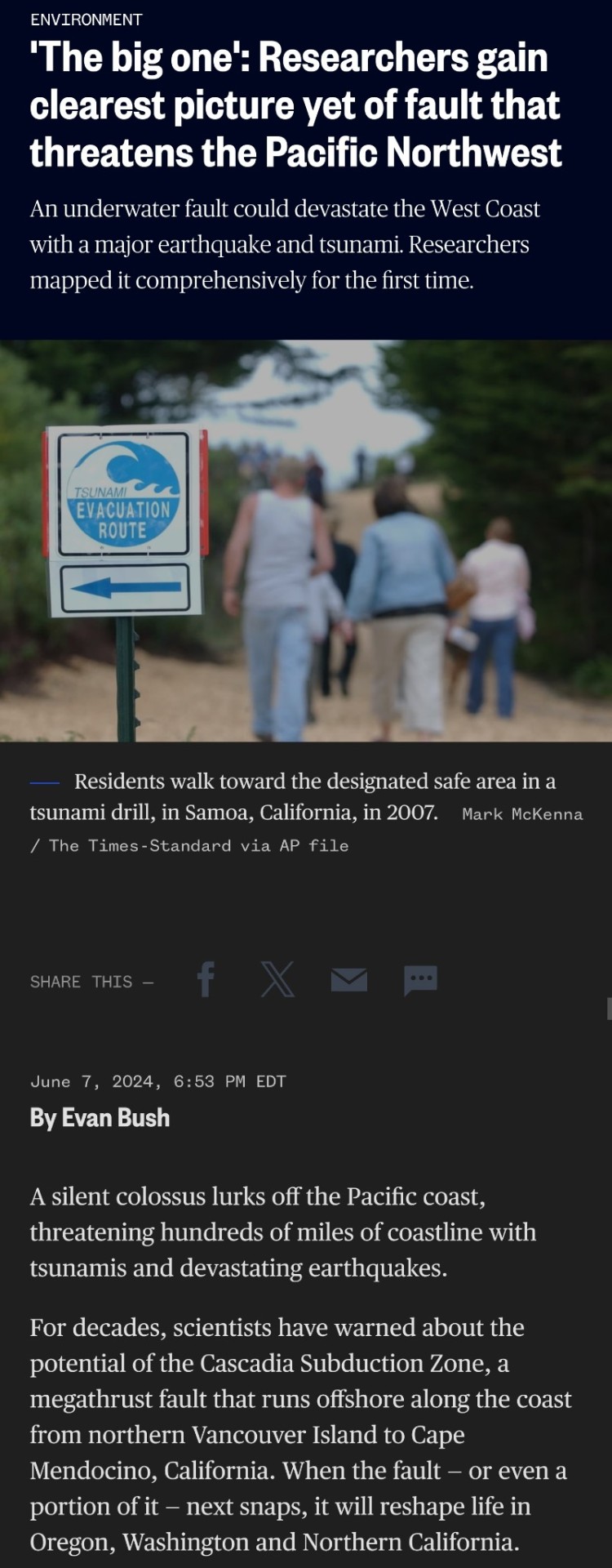
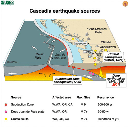
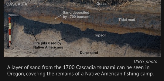
Of particular concern are signals of massive earthquakes in the region’s geologic history. Many researchers have chased clues of the last “big one”: an 8.7-magnitude earthquake in 1700. They’ve pieced together the event’s history using centuries-old records of tsunamis, Native American oral histories, physical evidence in ghost forests drowned by saltwater and limited maps of the fault.
But no one had mapped the fault structure comprehensively — until now. A study published Friday in the journal Science Advances describes data gathered during a 41-day research voyage in which a vessel trailed a miles-long cable along the fault to listen to the seafloor and piece together an image.
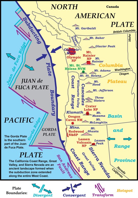
The team completed a detailed map of more than 550 miles of the subduction zone, down to the Oregon-California border.
Their work will give modelers a sharper view of the possible impacts of a megathrust earthquake there — the term for a quake that occurs in a subduction zone, where one tectonic plate is thrust under another. It will also provide planners a closer, localized look at risks to communities along the Pacific Northwest coast and could help redefine earthquake building standards.

“It’s like having coke-bottle glasses on and then you remove the glasses and you have the right prescription,” said Suzanne Carbotte, a lead author of the paper and a marine geophysicist and research professor at Columbia University’s Lamont-Doherty Earth Observatory. “We had a very fuzzy low-resolution view before.”
The scientists found that the subduction zone is much more complex than they previously understood: It is divided into four segments that the researchers believe could rupture independently of one another or together all at once. The segments have different types of rock and varying seismic characteristics — meaning some could be more dangerous than others.
Earthquake and tsunami modelers are beginning to assess how the new data affects earthquake scenarios for the Pacific Northwest.
Kelin Wang, a research scientist at the Geological Survey of Canada who was not involved in the study, said his team, which focuses on earthquake hazard and tsunami risk, is already using the data to inform projections.
“The accuracy and this resolution is truly unprecedented. And it’s an amazing data set,” said Wang, who is also an adjunct professor at the University of Victoria in British Columbia. “It just allows us to do a better job to assess the risk and have information for the building codes and zoning.”
Harold Tobin, a co-author of the paper and the director of the Pacific Northwest Seismic Network, said that although the data will help fine-tune projections, it doesn’t change a tough-to-swallow reality of living in the Pacific Northwest.
“We have the potential for earthquakes and tsunamis as large as the biggest ones we’ve experienced on the planet,” said Tobin, who is also a University of Washington professor. “Cascadia seems capable of generating a magnitude 9 or a little smaller or a little bigger.”

A quake that powerful could cause shaking that lasts about five minutes and generate tsunami waves up to 80 feet tall. It would damage well over half a million buildings, according to emergency planning documents.
Neither Oregon nor Washington is sufficiently prepared.
To map the subduction zone, researchers at sea performed active source seismic imaging, a technique that sends sound to the ocean floor and then processes the echoes that return. The method is often used for oil and gas exploration.
They towed a 9-plus-mile-long cable, called a streamer, behind the boat, which used 1,200 hydrophones to capture returning echoes.
“That gives us a picture of what the subsurface looks like,” Carbotte said.
Trained marine mammal observers alerted the crew to any sign of whales or other animals; the sound generated with this kind of technology can be disruptive and harm marine creatures. Carbotte said the new research makes it more clear that the entire Cascadia fault might not rupture at once.
“It requires an 8.7 to get a tsunami all the way to Japan,” Tobin said.
"The next earthquake that happens at Cascadia could be rupturing just one of these segments or it could be rupturing the whole margin,” Carbotte said, adding that several individual segments are thought to be capable of producing at least magnitude-8 earthquakes.
Over the past century, scientists have only observed five magnitude-9.0 or higher earthquakes — all megathrust temblors like the one predicted for the Cascadia Subduction Zone.
Scientists pieced together an understanding of the last such Cascadia quake, in 1700, in part via Japanese records of an unusual orphan tsunami that was not preceded by shaking there.
The people who recorded the incident in Japan couldn’t have known that the ground had shaken an ocean away, in the present-day United States.

Today, the Cascadia Subduction Zone remains eerily quiet. In other subduction zones, scientists often observe small earthquakes frequently, which makes the area easier to map, according to Carbotte. That’s not the case here.
Scientists have a handful of theories about why: Wang said the zone may be becoming quieter as the fault accumulates stress. And now, we’re probably nearing due.
.“The recurrent interval for this subduction zone for big events is on the order of 500 years,” Wang said. “It’s hard to know exactly when it will happen, but certainly if you compare this to other subduction zones, it is quite late.”
#science#geology#earthquakes#tsunami#natural disasters#Washington#Oregon#California#cascadia subduction zone#environment#PlanetFkd
4 notes
·
View notes
Text


Abiqua Falls, OR
Was part of the Grand Ronde member of the Columbia River Basalts, if I remember right.
The colonnade is beautifully preserved here, as is the more chaotic entablature off to one side.
Despite being a difficult trail which is both poorly marked and difficult to access, it still sees a fair amount of traffic, likely due to social media.
Last picture of a mushroom on a log.
6 notes
·
View notes
Text

Strange Geology
32 notes
·
View notes