#ancient pilgrimage routes
Explore tagged Tumblr posts
Visit Tumblr Blog
Explore Tumblr blogs with no restrictions, modern design and the best experience.
Last Seen Tumblr Blogs


Fun Fact
There were a total of 171.5 billion posts on Tumblr in 2019.
Text
Reviving Ancient Pilgrimage Routes for Modern Spiritual Seekers
Explore ancient pilgrimage routes like Camino de Santiago & Kumano Kodo. A spiritual journey for modern seekers to reflect, reconnect, and discover meaning.
#pilgrimage routes#ancient pilgrimage routes#spiritual seekers#pilgrimage travel#pilgrimage tips#mindful travel#pilgrim routes
0 notes
Text
Shipki La Pass Opens for Civilians | New Kailash Mansarovar Route via Himachal
#Aadhaar card border visit#ancient routes to Tibet#asia#border tourism India#CM Sukhvinder Sukhu#Himachal CM border announcement#Himachal Pradesh#Himachal to Tibet route#india#India Tibet route#Kailash Mansarovar from Shimla#Kailash Mansarovar Himachal#Kailash Mansarovar Yatra#Kailash pilgrimage route Himachal#Kailash via Himachal#Kinnaur Shipki La#Lord Shiva Himalayas#new pilgrimage route India#News#pilgrimage to Kailash#sacred Himalayan passes#sacred passes in India#Shipki La 2025 opening#Shipki La civilian access#Shipki La Pass#Shiva devotees pilgrimage#spiritual routes in Himalayas#Travel
0 notes
Photo

Etchmiadzin Cathedral
The Etchmiadzin Cathedral (also spelled "Echmiatsin,” “Echmiadzin,” and “Edjmiadsin”) is located in the city of Etchmiadzin (also referred to as Vagharshapat), Armavir Province in what is now present-day Armenia. It is geographically situated near the fertile valley of the Aras River, and it is not too far away from Mount Ararat, Armenia's capital, Yerevan, and Khor Virap Monastery. It is the spiritual center of the Armenian people, and the administrative center of the Armenian Apostolic Church. Called the “Mother Cathedral of Etchmiadzin” by Armenians, the cathedral is among the most ancient examples of Christian architecture anywhere in the world. Many scholars contend Etchmiadzin Cathedral is the oldest cathedral in Armenia, and it is widely believed that it is thus the oldest Christian cathedral in the world. The cathedral was designated as a part of a UNESCO World Heritage zone in 2000 CE — the zone also encompasses St. Gayane Church, St. Hripsime Church, and the archaeological ruins of Zvartnots Cathedral — due to its importance in Armenian religious and cultural history.
Armenia's Sacred Cathedral
The area surrounding Etchmiadzin Cathedral has been inhabited by various peoples since prehistoric times. Stone, Bronze, and Iron Age archaeological sites are located in or close around the city and cathedral. The area was well-known by the ancient people of Urartu; Etchmiadzin is referred to as "Kuarlini" in a Urartian cuneiform inscription, and the oldest documented information concerning Etchmiadzin's environs date from the reign of King Rusa II (r. 685-645 BCE). The city of Vagharshapat — today more commonly referred to as “Etchmiadzin” — was founded during the reign of the Arsacid king Vagharsh I (r. 117-140 CE). Although it was the capital city of Armenia for a time, the city's fortunes ebbed as it was attacked and destroyed during the Sasanid invasions of 368-369 CE. Soon thereafter, Vagharshapat was replaced as the political capital by Dvin in the 4th century CE. The city, however, remained prosperous due to its ideal position in the trade routes between the Roman Empire and Sasanid Persia. During the reign of Tiridates the Great (r. c. 298 - 330 CE), Christianity was adopted as Armenia's state religion, and Tiridates himself converted in 301 CE in the royal palace at Vagharshapat according to legends and Armenian historians.
The subsequent construction of Etchmiadzin Cathedral at Vagharshapat can be attributed to the life and work of Saint Gregory the Illuminator (also known as Grigor Lusavorich, c. 239 - c. 330 CE). If Armenian legends and historians are to be believed, Jesus Christ appeared to Saint Gregory the Illuminator in a vision, requesting that a cathedral be built within the ancient city. In the vision, Jesus Christ showed the exact spot where the proposed structure should lie, striking the ground with a golden hammer in his hands. Construction of Etchmiadzin Cathedral began around c. 303 CE. The cathedral was dedicated in turn to the Virgin Mary, and aptly named “Etchmiadzin” or “the descent (echnel) of the only begotten (miatsin).”
From the 5th to the mid-7th centuries CE, the city of Etchmiadzin grew quickly, developing into a major center of culture and pilgrimage. Successive bishops, over these two centuries, guaranteed the construction of further ecclesiastical buildings in close proximity to Etchmiadzin Cathedral, stimulating an epoch of Armenian cultural fluorescence. In the 7th century CE, under the guidance of the bishop Komitas of Aghdzk (r. 615-628 CE), Etchmiadzin began to pull in even more pilgrims following the construction of the Church of Saint Hripsime, which was named after the virgin who had been martyred by Tiridates the Great prior to his conversion to Christianity. The church of Saint Gayane was added around 616 CE and, in the 650s CE, the completion of the splendid Zvartnots Cathedral only added to the attractions, ensuring the city of Etchmiadzin became one of the most important pilgrimage sites in Armenia. The cathedral's wealth and reputation grew in importance in tandem with that of the city, attracting pilgrims from across the Christian Near East.
In 640 CE, following the invasion and occupation of Armenia by the Arabs under the Rashidun Caliphate (632–661 CE), the position of Etchmiadzin Cathedral and the city as a major religious center became precarious. Dvin and then Ani became Armenia's political and religious capitals, and the city of Etchmiadzin and its cathedral slowly fell into a period of decline. A major earthquake struck the region in the 10th century CE which caused the collapse of the Cathedral of Zvartnots, amongst other buildings, and the Seljuk Turks raided the area in the mid-11th century CE. By the late 13th century CE, after the onslaught of the Mongols in Armenia and Georgia, the environs surrounding the cathedral were so dilapidated that the celebrated Armenian poet Stepanos Orbelian (d. 1304 CE) felt compelled to compose his Lamentations on the Holy Cathedral of Vagharshapat.
The Cathedral of Etchmiadzin's fortunes revived, however, when the Armenian Apostolic Church decided to restore the catholicosate to the site in the mid-15th century CE. The country and its Christian population endured hardship and intermittent warfare with Safavid Iran under Ottoman Turkish rule, but the cathedral was given certain economic privileges, which enabled it to function until better days arrived. Construction and restoration projects occured in the 18th and 19th centuries CE, returning some lustre to the old cathedral. Imperial Russian rule (1827-1917 CE) gave the cathedral nearly a century of stability. While suppression returned in the early days of the USSR (1918-1949 CE), Etchmiadzin Cathedral endured and remains the “Holy Mother See of all Armenians.”
Continue reading...
32 notes
·
View notes
Text


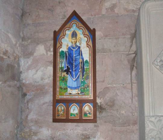
March 8th is the feast day of Saint Duthac, patron saint of the royal burgh Tain in Easter Ross in the Scottish Highlands, the Gaelic name for Tain is Baile Dubhthaich, means ‘Duthac’s town’.
Tain was an important place of pilgrimage in the middle ages. St Duthac was born here about 1000 AD, although some sources say Ireland, he was educated there and became a Celtic missionary. Now I know most of you will not have heard of him, but perhaps the whisky connoisseurs will know a little, as the local distillery, Glenmorangie produce a whisky “fit for a King” which honours St Duthac, who King James IV used to make an annual pilgrimage to Tain to honour.
Duthac died in 1065 and in 1253, his relics were returned to Tain and buried in the small chapel on the north east side of the town. Tales of miracles soon grew up round him and St Duthac’s chapel. It rapidly became one of the most important places of pilgrimage and sanctuary in Scotland. In 1427 the chapel was burnt down and his remains were transferred to the Collegiate Church in the centre of town. The peak of the shrine’s popularity as a place of pilgrimage came around 1500 with the repeated visits of King James IV.
Duthac’s remains disappeared during the turbulent times of the reformation when so many of the ancient churches and relics were lost. The Collegiate church was abandoned in 1815 when a larger church was built to replace it.
After the Reformation the saying of masses ceased, the trappings of pilgrimage were removed as well as the altar and it became the parish church, what would be described as a bog standard place, the reformers did not believe any place of worship should be embellished at all, not even the crosses, which from those days lost the image of Christ and any Celtic designs.
I’ll go back to the pilgrimages to Tain before the reformation, and one particular one when King James IV visited the relics of St Duthac on pilgrimage at least once a year between 1493 and his death at Flodden in 1513. However, the August 1513 visit was different. Firstly this was an unusual time of year for the king to travel to the shrine. Only one of the 19 recorded pilgrimages made by the king took place in August. He normally visited around the time of the feast day of St Duthac on 8 March, or after the harvest in October. The trip in 1513 was also unusually low key. Most of the flamboyant monarch’s visits to the north were accompanied by his minstrels and a large retinue. James IV visit Tain in 1513 may have been in order to seek a prophecy of military victory from Duthac.
There are plenty of precedents for this sort of behaviour by in the middle ages.
Without surviving diaries or letters we will never be sure of the exact motivations behind the doomed monarch’s last trip to the north. He may well have gone merely to seek the blessing of one of his favourite saints, or because he knew he would be on campaign at his normal pilgrimage time of October. Whatever the exact purpose, the visit by James to Tain in August 1513, his last act before invading England, underlines just how close a relationship the monarch had built up with a small northern town and its patron saint.
As well as the church named after him, there is a walk, called St Duthac's Way, one of the 8 pilgrim routes that make up The Way of St Andrews, you can read more about the routes here https://www.thewayofstandrews.com/
17 notes
·
View notes
Text

Puente de arco de piedra, cerca de Atapuerca, Burgos, 2011.
Hard to know how old this bridge may be. It is of an ancient design. Crossing a small stream it is on the Camino francés, the most popular route of the Camino de Santiago, and that pilgrimage is about a thousand years old. In many places the pilgrimage route followed roads built in the Roman era. Nearby is the archaeological site at Atapuerca where the oldest known proto-human remains in Europe have been unearthed showing the area was occupied by hominids 800,000 years ago.
#engineering#bridge#stone arch#history#burgos#castilla y león#españa#2011#photographers on tumblr#camino francés#camino santiago
17 notes
·
View notes
Text
The Path

The road to inner peace can take many forms – through meditation, good deeds, introspection, taking care of cherished loved ones…In some cases, it can also be a literal road. Down this path, one can embark upon a journey of self-discovery, a pilgrimage, a visit to a mysterious sage that is possessed of ancient wisdom, or just take the most convenient route to reach the monastery that’s been overtaken by a local (and possibly monstrous) tyrant and his bloodthirsty minions. Fully animated with a gentle breeze blowing about the blossoms of the venerable trees lining this road, and available in night-time and sparklier versions, let the serene beauty of this map lull your players into a false sense of safety as some terrible ambush or ominous vision is visited upon them. Highway to hell, or stairway to heaven? You decide!
#dnd#battlemap#dungeonsanddragons#rpg#ttrpg#dungeonmaster#fantasymap#tabletoprpg#dndmaps#roll20#worldbuilding#pathfinder#cartography#fantasymaps#fantasy#rpgmap#tabletop#mapmaking#dndart#map#battlemaps#tabletopgames#inkarnate#dungeonsanddragonsart#dndmap#fantasyrpg#rpgmaps#foundryvtt#angelamaps
10 notes
·
View notes
Text
Yes I did finally finish totk and can finally watch all the theory videos
I've been seeing alot of the idea that, while you completely forget who you are when you become a dragon there's this idea that your last thoughts become like your core
Zelda wanted to help Link, she is the only dragon completely passive to Link and helps you during the final fight
Ganon wanted to kill Link, and well, boss fight ensues
Been thinking many thoughts about Farosh, Dinraal and Naydra and who became them
Do you think their last thoughts were to protect the land? Did Farosh live right by a lake? Living with a nomadic tribe that changed which shores they lived by as food or seasons moved? Did she ever see the Gerudo? Have trade with them in the tougher months that they spent in the highlands? Did Dinraal live on death mountain or around it? In fertile ground perfect for farming, was she an explorer? A pilgrim? Does her flight path to the forgotten temple mean she saw it in her lifetime? Or is something in her she can't remember her drawing her to the ancient temple? Was Nayra a spiritual person? Spending her time at the goddess touched springs and holy pilgrimage routes, was she born in Hateno and look down at the town tucked at the bottom of her mountain as she prayed? Or was she born further north? Close enough to the Zora to be under their royal laws? To know how sacred and important water was? To see first hand what happens when Hyrules main water source freezes over?
Did living under the Thunderhead Isles bring down an endless thunderstorm on Farosh's lakes? Electrifying the water and killing all the fish
Did the lake basin supplying Hyrules rivers freeze? Was Nayra asked to pray desperately to an unhearing goddess at the frozen mountains peak for salvation, answers, anything at all?
Did death mountain erupt endlessly? Scorching the farming lands and causing widespread famine?
Did these three, who had some power, and a sacred stone, did they make the ultimate sacrifice to save their lands? Immortalizing their last thoughts of protection forever in a dragon watching overhead for eternity?
#mmmmmm dragon thoughts#if i am weak enough i may try my hand at drawing their non dragon forms#not today though#totk#zelda tears of the kingdom#legend of zelda#loz#farosh#dinraal#naydra#jellyfish's thoughts
59 notes
·
View notes
Text
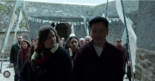
The Green(e) Route Revisited

This is not really a theory, it’s more like wild speculation bordering on outright fan fiction. I’m bringing it up because it sort of ties into my previous couple of theories on pilgrimage and Santiago de Compostela (here and here). Additionally, if the rumors about possible filming in Spain for season 3 prove to be right, this could potentially come into play.
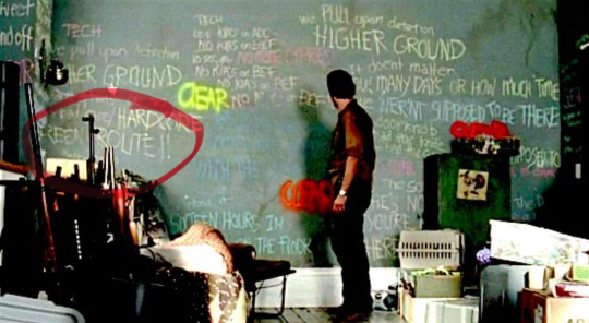
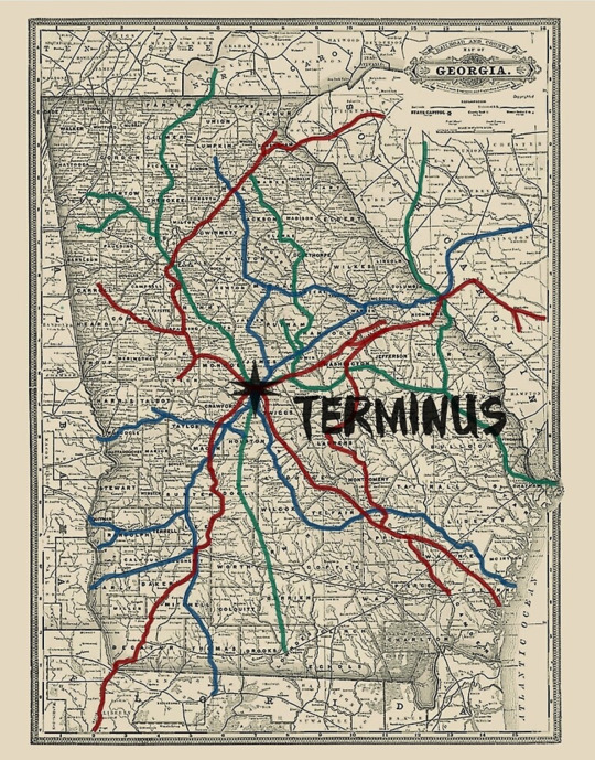
Back in the ancient days of Early TD, one of my favorite theories was the one that combined some of the writings on Morgan’s wall from clear, namely the “green route” seen on the wall behind Rick in the pic above, with the "green route" seen on the terminus map below.
TD latched on to the “green route” from Morgan’s wall as a potential way of bringing Beth back after her “death” in 5x8 Coda. Back then, we were all open to the idea that Morgan would somehow be involved, seeing as he featured so prominently in the coda after 5x8 Coda. And it was easy to think of the “green route” reference from 3x12 Clear as a reference to Beth, whose last name is “Greene”.
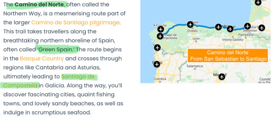
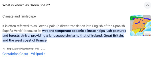
I talked about how Morgan had all these pilgrim vibes about him when we saw him in season 5 here. When I researched the pilgrim symbolism around Morgan the first time around, some time after 5x8 Coda, I came across evidence that the northern way to Santiago de Compostela is sometimes referred to as the “green way”, or the “green route”. This is apparently due to the vibrant colors of the landscape and vegetation along the northern Spanish Atlantic coast, and because of the discussions around the “green route” in TD at the time, this tickled my TD senses immensely.
This was also when I was starting to research the Sirius and North Star symbolism, as well as other astronomical references such as the Venus symbolism. It seemed like a pretty convenient coincidence that the name “Santiago de Compostela” refers to the “way under the field of stars” under which the pilgrims traveled to reach their destination. And on top of that, the “green way/green route” is literally “the Northern Way” which potentially could be a tie in with the “North symbolism" we’ve seen around Beth so much.
However, the pilgrim symbolism in TWDU didn’t really go anywhere… until it suddenly did. A St. Christopher medallion, which had been central to my initial theories on Morgan as a pilgrim, showed up if FTWD 6x2:

And now, after TWDDD 1x6 Home, we’ve had the first explicit mention of Santiago de Compostela, in that Losang, leader of The Nest, first came into contact with Laurent and the nuns after returning from a pilgrimage to Santiago de Compostela:
And obviously, we now have all these rumors that Daryl might be going to Spain for season 3.
In the original “green route “ theory from back in the days, @bluesandbeth theorized that the “green route” mentioned on Morgan’s wall was a reference to the green route on the terminus map, which ultimately ended up by the coast, offering a potential way for Beth to make her way to Alexandria Safe Zone by boat. Of course, it didn’t turn out like that, but I always loved the theory, it was well researched and plausible. And while it didn’t happen the way we first thought, I don’t think the “green route” symbolism has been fulfilled in any way, so as far as I’m concerned, it’s still very much in play.
Also, in 5x6 Consumed, we saw a very prominent green arrow, quite literally seconds before Carol and Daryl ran into Noah, which ultimately led them to Beth. It really feels like the green arrow, or the “green route”, is something that foreshadows a “destination” where Beth Greene is to be found. I don’t remember who first discovered that particular connection, I just know it wasn’t me. Whoever it was, it’s a great observation! (ETA; it was @galadrieljones)

(Thanks for the screenshots @wdway)
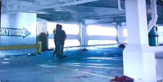
And for what it’s worth, the green arrow in Consumed pointed to a “skybridge”. I’ve recently talked a lot about bridges, ladders, stairwells and elevator shafts as metaphorical passages through which the characters can travel, and this is a perfect example of that. The green arrow (green route) pointed to the skybridge (metaphorical passage between the realm of the dead and the realm of the living), meaning it led to Daryl and Carol finding Beth. She went from being metaphorically trapped in the "realm of the dead" to being found alive in the "realm of the living". And it happened after meeting Noah on a skybridge.
Noah...
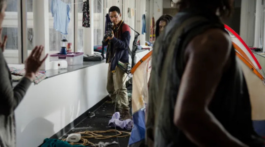
..who was wearing a t-shirt with a stylized version of the blue heron last seen in 4x12 Still:

I’ve talked about the symbolism around the heron in many posts. It was Noah’s t-shirt that foreshadowed the episode where we saw the second blue heron painting, in an episode that foreshadowed Rick’s “death” and “resurrection”. And the blue bird symbolism is still going strong in TWDU. It lead Daryl to Beth once, I believe it will do it again eventually.
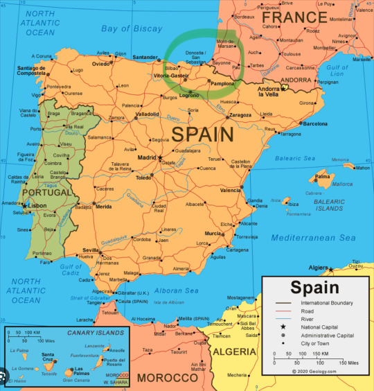
So, if the rumors about filming in Spain are true, could the “green way/green route” to Santiago de Compostela be key to a reunion between Daryl and Beth once again? The Northern Way starts in San Sebastián, just south of the French border, and interestingly, in TWDDD 1x1, we actually see Daryl move his finger across a map, from Marseille, France, where he washed up on the shore, to….
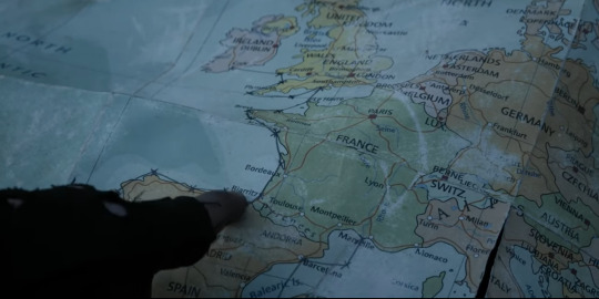
…literally San Sebastián, Spain. I’m not exaggerating, San Sebastián, starting point for the Northern Way, the Green Way, the Green Route to Santiago de Compostela, is LITERALLY right under his finger in this screenshot.
Could be a coincidence, sure. But it’s a very compelling one.
The filming in Spain hasn’t yet been officially confirmed as far as I’m aware, which is why I initially said that that this was more fan fiction than actual theorizing. There’s not really a whole lot of tangible evidence to support these speculations at this point. However, the stuff I wrote about in the pilgrim posts, such as the St. Christopher medallion and the reference to Santiago de Compostela, they are all canonically confirmed in the show. And so are the references to the “green route” from Morgan’s wall from 3x12 Clear, it exists in the canon of the show.
The symbolism around the green route hasn’t been fulfilled yet, and it is a fact that the Northern Way of the Camino de Santiago starts in San Sebastián, it is a fact that it goes through “Green Spain”, and if that’s not enough, there has always been an absolute abundance of “north” references around Beth.
And coincidence or not, Daryl did put his finger directly above San Sebastián on the map from 1x1….
#bethyl#team delusional#daryl dixon#beth greene#the walking dead#twd#team defiance#beth x daryl#daryl x beth#twddd#ddtboc
31 notes
·
View notes
Text
Sacra di San Michele

Photo thanks to the internet!
Sacra di San Michele sits on the top of Mt Pirchiriano (3100’), near the entrance to the Susa Valley. The valley has been one of the routes, since ancient times, connecting Italy to Northwest Europe. Mt Pirchiriano is one of the oldest places of worship dedicated to the Archangel Michael. It is in the center between Monte Sant’Angelo in Puglia and Mont Saint Michel in Normandy. The three make up an historic Pilgrimage.
The Abby came into being around 987 as a Benedictine Monastery. It fell into ruin in the 14th century and remained untended until 1836 when it was rescued by a Savoy king. It has been the property of the state since the mid-1800’s and today is the symbol of the Piedmont Region.
We took a 30 minute train ride from Torino to Sant’Ambrogio. From there, we hiked an ancient mule trail to the monastery. The views are supposed to be breathtaking but the weather did not cooperate. But, it was beautiful to see the abbey in the clouds.

The monastery and Mt Pirchiriano silhouetted behind the town of Sant’Ambroges.

The ancient Mule Trail. The trail is paved with rocks, which were smooth enough to allow the use of sledges to move stuff up and down the mountain.

It was not long, maybe a mile and a half, but it was a steep and steady climb. It took us about 90 minutes to reach the top. The downhill was much faster!

Paul on The Staircase of Death. The spaces around the stairs were used to bury both monks and benefactors of the abbey. Behind Paul you can see how the rock of the mountain face was incorporated into the structure.

This is the last ramp up to the church which is at the top of the complex. The flying buttresses are 19th century modifications.

The church is heavily restored, the last restoration completed in 1937. The church is built partially on a foundation and partially into the mountaintop itself.

A few original frescoes have been saved. This was our favorite. John the Baptist Preaching to the Animals. I love the unicorn! The lion and leopard are fun too!

There is a lovely terrace which, on a clear day, would offer views of the surrounding mountains and Susa Valley. Today, we were in a cloud.
On the return train ride, we were joined by a troop of fifty Boy/Girl Scouts who were heading into Turin for three days. They all had full camping gear but were staying inside somewhere. A twelve year old boy ended up sitting with us. He bravely tested his English, trying to make conversation. Very cute.
3 notes
·
View notes
Text

The first Cemetery I ever visited and was the Historic Key West City Cemetery. I was 5, I had a fixation on it and begged my mom to take me. A pull in my stomach to the gates. In the moment we entered, it felt like I was in a ancient garden full of Spirits. Little did I know this would be a catalyst to me beginning witchcraft. This also became one of our regular stops when we tale that route.
Growing up Cuban-American in Florida, going to the Keys was a holy tradition, a pilgrimage. This chain of islands is home to many Cuban Exiles, as well as to many other communities including one of the most vibrant queer and drag scenes in Florida.* We always go to the marker that says 90 miles to Cuba, and just look out into the Ocean. Sometimes we pray, or listen to stories told by our grandparents about life on La Isla, lamenting a Land some of us never touched and the rest have trouble remembering.
This is almost always followed by Cuban Food. Our tradition is to walk to El Meson de Pepe, a beautiful restaurant near the sea with art depicting Cuban and Cuban-American culture all over the walls. In one part of this restaurant, they have a small case that exhibits some Cuban history. Its full of historic documents and the such. My Abuelo always walks us through the exhibits to teach us our Ancestors’ history. This is where I learned who El Apostol, José Martí was, and Cuba’s long history of unrest and revolution. Martí inspired revolution against the fascist Spanish monarchy through his writings. I will go more in depth on Florida/Cuban Folk Saints soon.

José Martí, The Apostle.
Florida is a much different place from when I was growing up here. It seems we are progressing in the wrong direction more often than not. The Land and People are suffering. But Paradise is NOT Lost. Florida has always been full of people who’s history the current governor and his cohorts want erased, and we have always fought. We can’t give in to the voices saying to give up and flee. A freer Florida is just around the corner.
Bendiciones 🕯️
*(In Key West specifically. Instead of the ball drop every New Year, they elect a drag queen to be dropped in a high heel!)
#witchcraft#florida#bioregional animism#bruja#brujeria#florida witch#santeria#swamp witch#witch#traditional witchcraft#key west#jose marti#cuban
9 notes
·
View notes
Text
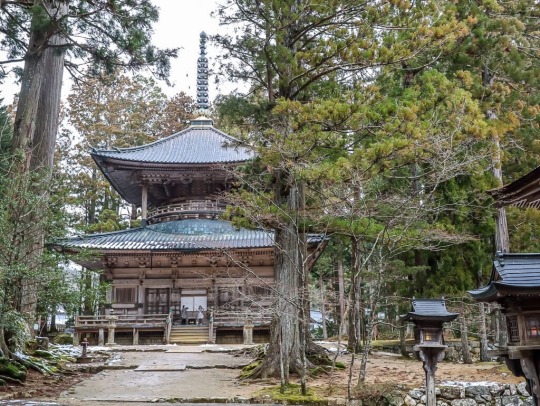
Koyasan - The Sacred Mountain of Shingon Buddhism
Nestled amidst the serene forests of the Kii Mountains in the north-eastern part of Wakayama Prefecture, south of Osaka, Koyasan, also known as Mount Koya, is a place of profound spiritual and historical significance. It is one of the three sacred sites, including Yoshino and Omine, and Kumano Sanzan, that are interconnected through ancient pilgrimage routes leading to the historic Japanese capital cities of Nara and Kyoto.
Koyasan is a place where time seems to stand still, where nature and spirituality blend seamlessly. This site is not merely a testament to religious devotion but also a reflection of the harmonious fusion of Shinto and Buddhism, two of Japan's most influential belief systems. Shinto, deeply rooted in Japan's ancient tradition of nature worship, coexists with Buddhism, introduced to Japan in the 6th century from China and the Korean Peninsula.
The origins of Koyasan's spiritual significance can be traced back to as early as the 9th century when several shrines were established, some predating the arrival of Buddhism in Japan. These shrines symbolize the rich tapestry of Japan's spiritual heritage and the coexistence of various belief systems over the centuries.
At the pinnacle of Koyasan stands Kongobuji, the principal temple of the esoteric Shingon Buddhist sect. Founded in 816 by the revered monk and scholar Kukai, also known as Kobo Daishi, this temple serves as the heart of spiritual practice in Koyasan. Kukai's vision transformed Koyasan into a sacred mountain for ascetic practitioners, and his legacy endures through the Shingon Buddhist tradition. Koyasan is home to a Designated National Treasure, featuring over 120 temples, each contributing to the spiritual ambiance and cultural significance of the area.
One of the most striking features of Koyasan is its Inner Sanctuary, which houses a vast cemetery, including the mausolea of many renowned figures in Japanese history. Among them is the final resting place of the 16th-century samurai ruler, Toyotomi Hideyoshi. This cemetery is not only a place of historical importance but also a testament to the enduring reverence for ancestors and the continuation of sacred traditions.
Koyasan is also marked by the grandeur of its Daimon Gate, which has stood as the main entrance to the temple complex since its inception. This gate, standing at a remarkable 25 meters in height, welcomes pilgrims and visitors alike, symbolizing the enduring spiritual journey that Koyasan represents.
Today, Koyasan continues to be an integral part of Japan's living culture. It is a place of deep spiritual connection and tranquility, attracting approximately 15 million visitors annually. The temple offers lodging facilities for pilgrims and visitors, allowing them to experience the serene ambiance of Koyasan and partake in its spiritual heritage.
In conclusion, Koyasan, with its rich history, spiritual significance, and cultural importance, stands as a testament to Japan's enduring reverence for the sacred and the coexistence of diverse belief systems. It is a place where the past seamlessly merges with the present, offering a unique and deeply enriching experience for all who visit.
12 notes
·
View notes
Text
ONLY THE DEAD FACE NORTH is alive!
It's aliiiiiiiiiivvveeee!

Please check out my first Kickstarter, bringing out the next in my Kitsune Tales series with an accompanying tabletop roleplaying game adventure.
Emperor Kazan ascended to the throne at the age of 17. At the age of 19, he abdicated by night and took religious orders at a nearby temple. This much is historical fact. Two centuries later, humans and yōkai race to find the lost imperial treasure allegedly hidden by Kazan along an ancient pilgrimage route, amid competing loyalties and navigating dangerous politics in both religion and government.
Click here: http://kck.st/3SHgQp5

#writblr#historical fantasy#ttrpg#kickstarter#japanese fantasy#japanese history#fantasy#books#writers#writers on tumblr
7 notes
·
View notes
Text
Rudraprayag, located in the Garhwal region of Uttarakhand, India, is a serene destination nestled amidst the majestic Himalayas. This quaint town is named after Lord Shiva (Rudra), and is renowned for its spiritual significance as the confluence of the Alaknanda and Mandakini rivers. While Rudraprayag is often visited by pilgrims en route to the Char Dham Yatra, it also offers an array of offbeat places in Rudraprayag that promise solitude, natural beauty, and a glimpse into the local culture.

One of the hidden gems among Rudraprayag offbeat places is the serene town of Gaurikund. Situated at an altitude of about 1,982 meters, Gaurikund is famous for its hot springs and the ancient Gauri Temple dedicated to Goddess Parvati. The trek to Gaurikund from Rudraprayag takes you through lush green forests and offers breathtaking views of the surrounding snow-capped peaks, making it a paradise for nature enthusiasts and adventure seekers alike.
For those interested in exploring the rich cultural heritage of Rudraprayag, a visit to Kartik Swami Temple is a must. Perched atop a hill at an altitude of 3,300 meters, this temple dedicated to Lord Kartikeya offers panoramic views of the Himalayas and the entire Rudraprayag valley. The trek to Kartik Swami Temple is an exhilarating experience, winding through forests and meadows dotted with rhododendron flowers, and is sure to leave a lasting impression on visitors.
Another lesser-known attraction in Rudraprayag offbeat places is Tilwara, a picturesque village known for its terraced fields and traditional Garhwali architecture. Located near the confluence of the Mandakini and Alaknanda rivers, Tilwara offers a tranquil environment ideal for relaxation and immersion in rural life. Visitors can engage with locals, explore the village trails, and savor traditional Garhwali cuisine, providing a glimpse into the authentic lifestyle of the region.
In conclusion, Rudraprayag offbeat places invite travelers to discover the hidden treasures of Uttarakhand beyond its famed pilgrimage sites. Whether you're drawn to the spiritual aura of ancient temples, the natural beauty of hot springs and scenic treks, or the charm of rural villages, Rudraprayag promises a memorable journey off the beaten path. Embrace the serenity, delve into the local culture, and create lasting memories in this enchanting corner of Incredible India.
#clearholidays#rudraprayag#offbeat places#offbeat tourism#uttarakhand offbeat#india travel#india tourism#incredible india#rudraprayag offbeat places#offbeat places in rudraprayag
2 notes
·
View notes
Photo

Abbey of Saint John at Müstair
The Abbey of Saint John at Müstair, located in the village of Müstair in Canton Graubünden, Switzerland, is an early medieval Benedictine monastery dating to the late 8th century CE that became an abbey in 1163 CE. It is renowned across Europe and the world for its beautiful, intact medieval design and decor, and UNESCO designated it as a World Heritage Site in 1983 CE as a result of its splendid mix of Carolingian figurative murals, Romanesque frescoes, and ancient stuccoes. For over 1200 years, the Abbey of Saint John at Müstair has remained a Benedictine religious community.
Origins
The Abbey of Saint John in Müstair (German: Benediktinerinnenkloster St. Johann; French: Abbaye Saint-Jean-des-Sœurs; Italian: Monastero benedettino di San Giovanni; Romansh: Claustra benedictina da Son Jon) is set deep within the southern Swiss Alps in the Val Müstair, which is in Switzerland's Graubünden Canton. Müstair is the only Swiss territory to be in the Adige Basin, and it is Switzerland's easternmost village. The town of Müstair lies very close to the Swiss-Italian border in South Tyrol, and it is also close to the Swiss-Austrian border at Nauders, Austria. The Abbey of Saint John in Müstair is roughly 130 km (80 miles) from Chur, Switzerland and 65 km (40 miles) from Merano, Italy.
According to local traditions in Graubünden, Charlemagne (King of the Franks from 768-814 CE; King of the Lombards from 774-814 CE; and Holy Roman Emperor from 800-814 CE) founded the monastery at Müstair in the late 8th century CE. Legend states that as Charlemagne traversed the Umbrail Pass between the villages of Bormio and Santa Maria following his coronation as King of the Lombards in nearby Italy in 774 CE, he survived a snowstorm. There and then, Charlemagne decided to establish a monastery on the spot to commemorate his miraculous survival. Dendrochronology confirms that the wood used in the construction of the monastery was felled around c. 775 CE, so the legend could indeed be true. It is likely, however, that it was the Bishop of Chur who founded the monastery at Charlemagne's royal behest; Chur was the traditional capital of Graubünden and remains the canton's largest city too.
Aside from any miraculous survival and piety, Charlemagne undoubtedly recognized the region in and around Müstair as one of strategic and cultural importance. Lying between the trade- and pilgrimage routes, which crisscrossed the Alps between Switzerland, Germany, Austria, and Italy, Müstair was an ideal location for a Benedictine monastery that could operate as a hospice, accommodating pilgrims and travelers in the regions of Valtellina, Tyrol and Engadine. As a religious institution and center, the monastery would be able to tend to the religious needs of the local community as well.
Continue reading...
25 notes
·
View notes
Text


March 8th is the feast day of Saint Duthac, patron saint of the royal burgh Tain in Easter Ross in the Scottish Highlands, the Gaelic name for Tain is Baile Dubhthaich, means ‘Duthac’s town’.
Tain was an important place of pilgrimage in the middle ages. St Duthac was born here about 1000 AD, although some sources say Ireland, he was educated there and became a Celtic missionary. Now I know most of you will not have heard of him, but perhaps the whisky connoisseurs will know a little, as the local distillery, Glenmorangie produce a whisky “fit for a King” which honours St Duthac, who King James IV used to make an annual pilgrimage to Tain to honour.
Duthac died in 1065 and in 1253, his relics were returned to Tain and buried in the small chapel on the north east side of the town. Tales of miracles soon grew up round him and St Duthac’s chapel. It rapidly became one of the most important places of pilgrimage and sanctuary in Scotland. In 1427 the chapel was burnt down and his remains were transferred to the Collegiate Church in the centre of town. The peak of the shrine’s popularity as a place of pilgrimage came around 1500 with the repeated visits of King James IV.
Duthac’s remains disappeared during the turbulent times of the reformation when so many of the ancient churches and relics were lost. The Collegiate church was abandoned in 1815 when a larger church was built to replace it.
After the Reformation the saying of masses ceased, the trappings of pilgrimage were removed as well as the altar and it became the parish church, what would be described as a bog standard place, the reformers did not believe any place of worship should be embellished at all, not even the crosses, which from those days lost the image of Christ and any Celtic designs.
I’ll go back to the pilgrimages to Tain before the reformation, and one particular one when King James IV visited the relics of St Duthac on pilgrimage at least once a year between 1493 and his death at Flodden in 1513. However, the August 1513 visit was different. Firstly this was an unusual time of year for the king to travel to the shrine. Only one of the 19 recorded pilgrimages made by the king took place in August. He normally visited around the time of the feast day of St Duthac on 8 March, or after the harvest in October. The trip in 1513 was also unusually low key. Most of the flamboyant monarch’s visits to the north were accompanied by his minstrels and a large retinue. James IV visit Tain in 1513 may have been in order to seek a prophecy of military victory from Duthac.
There are plenty of precedents for this sort of behaviour by in the middle ages.
Without surviving diaries or letters we will never be sure of the exact motivations behind the doomed monarch’s last trip to the north. He may well have gone merely to seek the blessing of one of his favourite saints, or because he knew he would be on campaign at his normal pilgrimage time of October. Whatever the exact purpose, the visit by James to Tain in August 1513, his last act before invading England, underlines just how close a relationship the monarch had built up with a small northern town and its patron saint.
As well as the church named after him, there is a walk, called St Duthac's Way, one of the 8 pilgrim routes that make up The Way of St Andrews, you can read more about the routes here https://www.thewayofstandrews.com/
21 notes
·
View notes
Text
Article from The Conversation on our Chicano Park research.
Urban wellbeing is increasingly tied to what urban planners term “green” and “blue” spaces: the parks and waterfronts that our towns and cities may include. Residents are also encouraged to leave the city altogether, to seek out the healthy calm of forest bathing, fell running or cold water swimming.
The potential of play within the urban environment, however, is often overlooked.
Skateboarders have long been invested in what I call “grey” space: the overlooked corners, edges and surfaces of the built environment. Skateboard magazines and videos routinely explore the social and architectural histories of sets of stairs and stone benches.
These spots, largely invisible to the general public, are richly symbolic. In seeing them as ramps and launchpads, skaters transform unremarkable bits of the city into ritual places of magic and wonder.
Recent research conducted with my colleague, Andrea Buchetti, shows that skateparks are sites of unstructured play and community, as well as remembrance and ritual. Otherwise banal and polluted locations are afforded layers of meaning and depth.
Skatepark memorialisation
The Chicano Park skatepark in San Diego is nestled below the imposing, blocky concrete columns of the on-ramps for the city’s Coronado bridge.
Built in 2015, the skatepark features four vibrant murals (by artists including Ricardo Islas) that draw on both the indigenous heritage of this ancient northern Mexican region and skateboard iconography. In memory of lost friends, local skateboarders build shrines at the foot of the paintings using broken skateboards, rocks, cacti and cut flowers.
The five-lane highway bridge above it stands 61 metres tall, allowing safe passage for ships bound to the nearby naval base. Completed in 1969, it links downtown San Diego with the smaller city of Coronado across San Diego Bay.
The space beneath the bridge has long been contested. When built, its route divided a longstanding Mexican American neighbourhood, Barrio Logan, that had already been disrupted by the construction of the Interstate 5 in 1963. Over 5,000 homes and businesses were destroyed in the process.
The state had promised the community a park by way of compensation. But on April 22 1970, Mario Solis, a local student, noticed bulldozers where the park should be, and found out the city was, in fact, constructing a highway patrol base there.
At Solis’s urging, more than 250 residents gathered with shovels and pickaxes to reclaim the land. They planted cacti and trees to create a communal park. After three months of protest, the city conceded to work with the community, and Chicano Park was officially established.
Local artist Salvador Torres was one of the people who lost their homes. In 1973, he galvanised the community into painting murals on the imposing chunks of concrete built in their stead. It was a form of creative resistance. The motifs referenced the cultural heritage of this ancient northern Mexican region, from Aztec symbolism to indigenous plants and beasts, and also Mexico’s colonial experience and revolutionary struggles.
The park is now a protected historic space and landmark. People gather there for annual celebrations on April 22.
Skateboarding as culture and community
Research has long shown the connection between sport and religion. Fans make pilgrimages to stadiums and worship athletes like gods.
Just as a football fan might worship at Wembley stadium in London, a specific neighbourhood curb might hold great significance because of a connection to a famous skater or a historic event. I have shown how skateboarding functions as a lifestyle religion. In the way they observe, perform and organise their communal activity, skateboarders derive spiritual expression and identity from both the physical act of skateboarding and the places in which it is conducted.
Some skateparks have dedicated plaques and permanent memorials designed into skateable features. When legendary San Francisco skateboarder and chief-editor of Thrasher magazine, Jake Phelps, died in 2019, a sculptor in Los Angeles made a concrete tombstone feature to install in the Lower Bob’s DIY skatepark in Oakland. He mixed some used dental floss Phelps had left behind into the concrete. “We don’t got his cremated body,” the artist told Thrasher, “but we got pretty much all the DNA we’re gonna need.”
London’s Skateboard Graveyard on one of the supports of Hungerford Bridge, on the South Bank, is another salient example. For years now, old boards have been thrown down from the Golden Jubilee footbridge in memory of Timothy Baxter, one of two skaters who were attacked and thrown into the river Thames in 1999.
Baxter died as a result and the juvenile attackers were convicted of manslaughter. Many of the skateboarders who take part in the ritual might not know that this is how it began, yet they persist in offering their broken boards to the site.
RIP epitaphs
In 2023, the skatepark in Sacramento’s Regency Park was renamed in honour of Tyre Nichols, a skateboarder who was beaten to death by police officers in Memphis, Tennessee.
Australian graphic design expert Dan Johnston has identified RIP epitaphs as one of the most common types of skateboarding-related graffiti. He cites messages he has noted on the steel ramps and concrete bumps of skater desinations in Singapore, Paris and south Australia – RIPs and Miss Us scrawled in white correction fluid, marker pen or spray paint.
Despite skateboarding’s recent ascent to Olympic status, for many skateboarders it is more a culture – or even a cult – than a sport. It brings diverse people together for unsanctioned play, recasting obstacles – an impassable buckled road in Wiltshire, say – as toys and tools.
In their provocative curves and surfaces, skateparks embody this creativity. They mimic the city beyond, showing how the built environment cannot just be conceived of as a framework for economic activity. Grey space – and grey times – can be transformed if communities, and the DIY cultures they give birth to, are allowed to flourish in the city.
4 notes
·
View notes