#ahaggar mountains
Explore tagged Tumblr posts
Text

Mushroom rock, Tamanrasset, Algeria: Unusual Mushroom rock also known as Pedestal rock is located in Tamanrasset, Saharian desert, Algeria. This naturally occurring rock is formed as a result of wind erosion and weathering and this unique shape is due to the different rate of wind erosion at the top and bottom of the rock... Tamanrasset, also known as Tamanghasset or Tamenghest, is an oasis city and capital of Tamanrasset Province in southern Algeria, in the Ahaggar Mountains. It is the chief city of the Algerian Tuareg. It is located at an altitude of 1,320 metres. Wikipedia
142 notes
·
View notes
Text

Hiking through the extreme heat of the Ahaggar Mountains.
Algeria
1981
#vintage camping#campfire light#algeria#ahaggar mountains#hoggar mountains#history#hiking#camping#travel#exploring#1980s
36 notes
·
View notes
Text
Ahaggar Mountains
Photo: Volcanic rocks, landscape of Atakor, Hoggar, Ahaggar Mountains, Wilaya Tamanrasset, Algeria, Sahara, North Africa. Photo by imageBROKER.com Nestled in the heart of the Sahara Desert, the Ahaggar Mountains stand as a breathtaking testament to Algeria’s diverse natural beauty. Known for their rugged landscapes, dramatic peaks, and rich cultural heritage, these mountains are often referred…
0 notes
Text
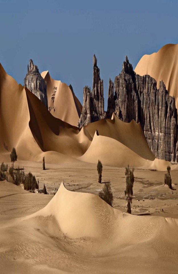
▪️The Massif de Hogar is a mountain range that rises suddenly to the west of Tamanrassete, Algeria. The region has an average height of 900 meters above sea level, the highest point is Mount Tahat, in the center of Atakor. It culminates at 3,003 meters high, and is also the highest peak in Algeria. The Hogar massif is essentially made up of volcanic rocks and constitutes a vast rocky region within the Sahara desert.
▪️The Hoggar Mountains are home to the Ahaggar National Park, one of the country's national parks. ▪️The Hoggar mountain range typically has hot summers, with a cold climate in winter. Temperatures drop below freezing in winter. Precipitation is rare and sporadic throughout the year. However, because the climate is less extreme than in most other areas of the Sahara, the mountains are an important location for biodiversity, including a number of relict species. The Hoggar Mountains are part of the Western Sahara montane xeric forests ecoregion.
▪️The park also contains a population of herbivores, such as the Saharan subspecies of the Berber sheep and the Dorcas gazelle.
The vegetation in this area includes trees such as Vachellia tortilis, Vachellia seyal, myrtle and Tamarix aphylla which are spread throughout the area. Other plants may include Citrullus colocynthis and Calotropis procera .
▪️The Hogar massif is the land of the Imuagues, a tribe of the Tuareg people. The oasis of Abalassa near the town of Tamanrassete is the site of the tomb of the famous leader Tin Hinan, the matriarch believed to have been the ancestor of the Tuareg people in the Hogar Mountains.
📸 By Дмитрий Дубиковский
131 notes
·
View notes
Text
THE QUEEN TIN HINAN!
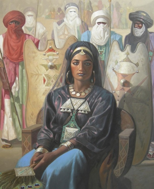
(Painting of The Queen Tin Hinan by Hocine Ziani)
The Queen Tin Hinan, also known as Queen of the Hoggar, is a legendary woman that lived in the 4th Century whose skeleton was found in a pre-Islamic tomb in the Ahaggar Mountains. The literal meaning of Tin Hinan is “she of the tents.” She is believed to be the ancestress of the Tuareg ethnicity of northern Africa; they call her “The mother of us all.”
As centuries went by, her character gradually faded into myth and folklore until the discovery and opening of her tomb in 1925. the discovery reaffirmed her existence. Like many centuries old legendary characters, her true origin has become shrouded in mystery. Sadly without any real documented evidence because the Tuaregs of that time did not keep written records, oral narratives by the locals is a key option in retracing her history.
There are sources that say Tin Hanin was a princess driven from the Northern Sahara, and after a near-death journey through the Sahara Desert with her entourage, they reached the desert anthill where luckily they found grain.
Some say she was a Berber moslem who came from the Tafilalt oasis. with her maidservant Takamat. that she might have had a daughter called Kella. they settled in the mountainous region of Algeria. There is no record anywhere of her tribe, whom her husband or lover was, why she migrated to Hoggar, whom her parents were or the cause of her death.
Takamat had two daughters. Historians believe Tin Hinan gave the Oasis of Silet and Ennided to the two daughters of Takamat which til present day belongs to the descendants of the two women.
LEGEND
Tin Hinan accomplishments were no mean feat. As a woman coming from a foreign land she had to establish herself in the new territory and judging from history’s treatment of women during those times one can only imagine her level of wisdom, Intelligence, courage and endurance as she overcame opposition, won the hearts of the people, united them and rose to become their queen.
She was regarded as a fearless warrior; many Tuaregs today refer to her as the African Amazon Queen. She possessed a knowledge of herbs for healing and medicinal practices, taught her people poetry and the Tifinagh alphabet. Her greatest achievement was founding, uniting the Tuaregs and establishing a kingdom in the Hoggar. Her daughter Kella is widely judged to be the founder of the Kel Rela Tribe.
Under the leadership of Queen Tin Hinan, the Tuaregs established essential caravan trading routes through which they built great wealth and economic prosperity throughout the 4th and 5th century.
TIN HINAN TOMB
It was not until 1925 that Tin Hanin resurfaced again. A Polish American archaeologist Byron Khun De Porok unpopular within the science community at the time and dubbed “The Tomb Raider” discovered her tomb at the Hoggar regions of Abalessa in Southern Algeria.
It was a Circular stone structure on a hill with a height of about 4 meters and a diameter of about 23 meters overlooking a dried river bed. It contained a number of rooms but only had one entrance.
Upon opening her tomb, Byron found the remains of the queen lying on her back legs crossed and covered with a red cloak of leather that had since turned to dust; she lay on a wooden litter her head facing east and was heavily adorned with gold and jewels. She wore seven silver and seven gold bracelets on her left and right arms respectively and a necklace of gold and pearls. A separate silver bracelet and a Gold ring were placed beside the body. Other funerary items and many pieces of jewelry like beads of turquoise, garnet, amazonite, and cornelian were also discovered in the tomb.
In the 1960s, the anthropologist E. Leblanc examined the skeleton within the Tin Hinan tomb. He observed that the remains were tall (1.72 to 1.76 meters tall) and lithe, with a narrow pelvis, broad shoulders and slender legs.
Today her remains can be found in the Bardo Museum of Algiers.
3 notes
·
View notes
Text
''قافـــلـــة الايـــموهاغ '' الـــــطـــــوارق
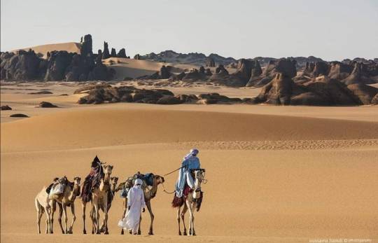
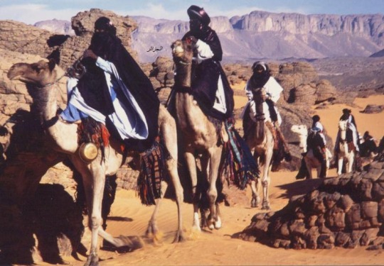
CARAVAN OF IMOHAGH - La caravane des Imoûhagh Touareg 🐪🐪🐪🐪🐪🐪
الـــــــجزائـــــــــــــر_ Algeria
منذ اقدم العصور جاب الطوارق الايموهاغ الصحراء بقوافلهم فاحيوا الواحات و المخيمات و المجتمعات السكانية و قامو بتامين تبادل تجاري و ثقافي, حيث كان هناك قوافل تسافر لعدة اشهروكانت مكونة في بعض المرات مثل قافلة الملح " الزاي " بما يزيد عن الالف جمل .
Depuis la nuit des Temps, les TOUAREGS ont sillonné le Sahara en tous sens avec leurs caravanes, faisant vivre les oasis, les campements, les centres de vie, assurant les échanges commerciaux et culturels. Les caravanes partaient pour plusieurs mois et certaines étaient constituées, comme l’Azalaï la caravane du sel, de plus de 1000 dromadaires.
Since the dawn of Time, theTUAREG have crossed the Sahara in all directions with their caravans and live oasis, encampments, living centers, providing the commercial and cultural exchanges.
The caravan left for several months and were incorporated, as the caravan Azalaï salt, more than 1,000 camels.
La Grande Caravane de l’Ahaggar au Tassili N’Ajjer
C’est la piste des rezzou d’autrefois que vous suivez. De Tamanrasset à Djanet, 700 km à dos de dromadaire. Sur votre parcours, les oueds et campements de l’Est de l’Ahaggar, de vieilles montagnes volcaniques, les ténérés d’Amadghor et du Tafessasset, les grandes dunes de l’erg Admer, les falaises du tassili N’Ajjer
The Big Caravan
From Ahaggar to Tassili of N'Ajjer
This is the track of past raids that you follow. Tamanrasset to Djanet, 700 km camel. On your journey, wadis and settlements in eastern Ahaggar, ancient volcanic mountains, Ténéré of Amadghor Tafessasset, the large dunes of Erg Admer, cliffs of Tassili N'Ajjer
21jours & 22 nuits / 21 days & 22 nights
Caravane de l’Ahaggar
Au fil des oueds qui serpentent comme des veines entre les collines de l’Est de l’Ahaggar vous découvrez des campements de zéribas, des jardins sahariens, des gravures rupestres, des oiseaux, vieux volcans.
Ce voyage peut se faire à deux ou à plus que deux personnes
Caravan of Ahaggar
Over the wadis that wind like veins in the hills east of the Ahaggar you find camps of zéribas (huts), Saharan gardens, rupestral engravings, birds, old volcanoes.
🐪🐪🐪🐪🐪🐪🐪🐪🐪🐪🐪🐪🐪🐪🐪🐪🐪🐪


21 notes
·
View notes
Text

Tuareg people
The Tuareg people are a large Berber ethnic group that principally inhabit the Sahara in a vast area stretching from far southwestern Libya to southern Algeria, Niger, Mali, and Burkina Faso. Traditionally nomadic pastoralists, small groups of Tuareg are also found in northern Nigeria.
They are a semi-nomadic people who practice Islam, and are descended from the indigenous Berber communities of Northern Africa, which have been described as a mosaic of local Northern African (Taforalt), Middle Eastern, European (Early European Farmers), and Sub-Saharan African-related ancestries, prior to the Arab expansion. Tuareg people are credited with the spreading of Islam in North Africa and the adjacent Sahel region.
Tuareg society has traditionally featured clan membership, social status and caste hierarchies within each political confederation.
The Tuareg have controlled several trans-Saharan trade routes and have been an important party to the conflicts in the Saharan region during the colonial and post-colonial era.
In the late 19th century, the Tuareg resisted the French colonial invasion of their Central Saharan homelands and annihilated a French expedition led by Paul Flatters in 1881. However, in the long run Tuareg broadswords were no match for the more advanced weapons of French troops. After numerous massacres on both sides,[30] the Tuareg were subdued and required to sign treaties in Mali 1905 and Niger 1917. In southern Algeria, the French met some of the strongest resistance from the Ahaggar Tuareg. Their Amenokal, traditional chief Moussa ag Amastan, fought numerous battles in defence of the region. Finally, Tuareg territories were taken under French governance.
Post-colonially, when African countries achieved widespread independence in the 1960s, the traditional Tuareg territory was divided among a number of modern states: Niger, Mali, Algeria, Libya, and Burkina Faso. Competition for resources in the Sahel has since led to conflicts between the Tuareg and neighboring African groups, especially after political disruption following French colonization and independence. There have been tight restrictions placed on nomadization because of high population growth. Desertification is exacerbated by human activity i.e.; exploitation of resources and the increased firewood needs of growing cities. Some Tuareg are therefore experimenting with farming; some have been forced to abandon herding and seek jobs in towns and cities.
In Mali, a Tuareg uprising resurfaced in the Adrar N'Fughas mountains in the 1960s, following Mali's independence. Several Tuareg joined, including some from the Adrar des Iforas in northeastern Mali. The 1960s' rebellion was a fight between a group of Tuareg and the newly independent state of Mali. The Malian Army suppressed the revolt. Resentment among the Tuareg fueled the second uprising.
This second (or third) uprising was in May 1990. At this time, in the aftermath of a clash between government soldiers and Tuareg outside a prison in Tchin-Tabaraden, Niger, Tuareg in both Mali and Niger claimed autonomy for their traditional homeland: (Ténéré, capital Agadez, in Niger and the Azawad and Kidal regions of Mali). Deadly clashes between Tuareg fighters (with leaders such as Mano Dayak) and the military of both countries followed, with deaths numbering well into the thousands. Negotiations initiated by France and Algeria led to peace agreements (11 January 1992 in Mali and 1995 in Niger). Both agreements called for decentralization of national power and guaranteed the integration of Tuareg resistance fighters into the countries' respective national armies.
Major fighting between the Tuareg resistance and government security forces ended after the 1995 and 1996 agreements. As of 2004, sporadic fighting continued in Niger between government forces and Tuareg groups struggling for independence. In 2007, a new surge in violence occurred.
Since the development of Berberism in North Africa in the 1990s, there has also been a Tuareg ethnic revival.
Since 1998, three different flags have been designed to represent the Tuareg. In Niger, the Tuareg people remain diplomatically and economically marginalized, remaining poor and not being represented in Niger's central government.
+ https://en.wikipedia.org/wiki/Tuareg_people
1 note
·
View note
Photo

SERGIO RICCA - flickr
Algeria
Ahaggar Mountains National Park
Algeria's Ahaggar National Park covers an area of approximately 450,000 square kilometers in the Saharan Algeria Region in the extreme south of the country. The closest populated area near the park, which lies in a desert mountainous zone, is the oasis city of Tamanrasset. The Ahaggar Mountains, also known as the Hoggar, dominate the park, with the highest peak being Mount Tahat, measuring 3,003 meters above sea level.


Photos: Eric Montfort - flickr


Photos: Tato Edroso - flickr


Photos: SERGIO RICCA - flickr


Photo: Brigitte Djajasasmita - flickr
#ahaggar mountains national park#ahaggar mountains#algeria#sahara desert#hoggar#mount tahat#nature#tassilis#assekrem
4 notes
·
View notes
Text
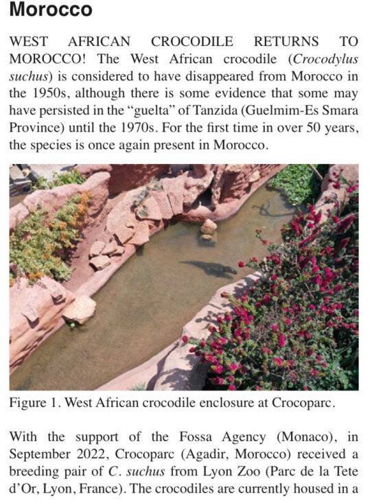
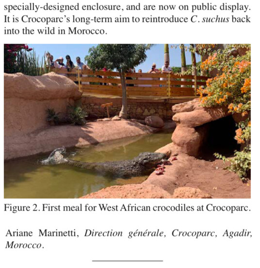
WEST AFRICAN CROCODILE RETURNS TO MOROCCO!
The West African crocodile (Crocodylus suchus) is considered to have disappeared from Morocco in the 1950s, although there is some evidence that some may have persisted in the “guelta” of Tanzida (Guelmim-Es Smara Province) until the 1970s. For the first time in over 50 years, the species is once again present in Morocco.
---
Images, captions, layout, screenshots, and all text above from: Ariane Marinetti. In: Crocodile Specialist Group Newsletter. Volume 41 No. 3. July 2022 -September 2022.
For context:

The West African crocodile is also known to some researchers as the “sacred crocodile” for its association with the deity Sobek and crocodile veneration in ancient Egypt. Though the creature inhabits tropical woodland landscapes across most of West Africa, it is also sometimes described as the “desert crocodile” because of how some populations live in oases in the Sahara, in small pools amidst vast desert. The sites in Morocco where crocodiles were historically reported are at the northern edge of the Sahara, far removed from other contiguous populations of crocodiles in the tropics. Previously, the West African crocodile (Crocodylus suchus) was considered to be the same species as the Nile crocodile (Crocodylus niloticus). Research in recent years has shown that the West African crocodile is a unique species, and it was historically present at sites across North Africa and the Sahara, including at sites in the Tassili n’Ajjer and Ahaggar mountains of Algeria. Crocodiles were reported to have survived in the Draa river system in Morocco until at least the 1940s. Crocodiles were even reported within the 20th century to survive near the Mediterranean coast (!), at Chott el-Djarid in Tunisia. Though both West African crocodiles and Nile crocodiles seem to be present in Egypt, many mummified crocodiles from ancient Egyptian sites have also been determined to be the West African crocodile. At times throughout the Holocene over the past 12,000 years, much of the Sahara featured savanna landscapes, and the “desert’ was home to many rivers and wetlands, now vanished. Even as the desert became dry, some hippopotamus and crocodiles survived in oasis landscapes in isolated parts of the Sahara. Today, some oasis sites in Mauritania provide a cool illustration of this lifestyle, as West African crocodiles still swim in isolated pools, gueltas, tiny spring-fed streams, and small caves surrounded by desert.
741 notes
·
View notes
Photo

Hoggar Mountains, Algeria
This image shows an ancient volcano located in southern Algeria. After some searching, I believe the correct name for this object is the Lharen phonolitic plug.
This photo was taken in an area of southern Algeria known as the Hoggar Mountains which makes up the Ahaggar National Park (Hoggar and Ahaggar seem to be interchangeable in the translations).
The Hoggar Mountains sit in the heart of the Saharan desert close to the southern tip of Algeria, close to the Tropic of Cancer. They sit on top of a broad plateau and are composed of volcanic rocks erupted over the last 40 million years. The most active portion of the volcanism took place between 12 and 20 million years ago and the rocks in this image date from that period.
This outcrop is a volcanic plug, the remnants of the inside of a volcano. This rock was formed by lava that migrated upwards inside a volcanic system but was stranded when the supply from below was cut off and the volcano died.
The rocks show columnar jointing; that’s the pattern of near vertical lines and cracks you see. Columnar jointing always forms lines in the direction cooling is happening; this rock cooled from above, suggesting that it was originally surrounded by a larger volcanic mass that shielded the sides from cooling.
Most of the outer volcano has been eroded away, but the plug in the volcano likely cooled slowly, generating a crystalline rock which is strong and resistant to erosion. The debris pile around it is some remnants of the erosion of the plug and the mountain around it. The rock itself is a phonolite, a common type of magma found in crustal igneous settings.
The cause of the volcanism in this area is enigmatic. The volcanic rocks are coming through the thick crust of northern Africa but have chemical signatures suggesting they were derived from the mantle. They could have been formed due to a small hotspot underneath this portion of Africa, or they could represent a product of the collision between Europe and Asia far to the north, which could break the crust throughout the continent and cause enough movement within the mantle to cause generation of the magmas that eventually formed this plug.
-JBB
Image credit: Patrick Gruban http://www.flickr.com/photos/gruban/137349085/
A data compilation source thanks to Dr. Anderson’s page: http://www.mantleplumes.org/Hoggar.html
World Geography entry: http://world-geography.org/mountain/12-ahaggar-mountains.html
http://www.volcanolive.com/tahalra.html
#Hoggar mountains#Geology#Algeria#sahara#desert#nature#landscape#Travel#Research#erosion#volcanic plub#the earth story#Ahaggar#national park#columnar jointing#phonolite
75 notes
·
View notes
Photo

NEW MAP: Northern Africa 1906: Conquest of the Sahara (12 February 1906) https://buff.ly/3iCuA02 The first French military expeditions crossed the Sahara in 1900, defeating the Ahaggar Tuareg in 1902. However, it was not until 1906 that the French sent a permanent occupation force to Agadez and thereby secured their control of trans-Saharan trade to the west of the Tibesti Mountains. #1900s #1906 #20thcentury #agadez #algeria #frenchsahara #cartografia #cartographic #sahara #francophone #france #frenchwestafrica #frenchempire #historian #historical #historicalplace #historylesson #historylover #mali #mapping #maps #morocco #niger #northernafrica #empire #colonialism #imperialism #ottomanempire #britishempire #newmap (at Agadez) https://www.instagram.com/p/CCVfa4fAwjO/?igshid=1d8slh74r4gy1
#1900s#1906#20thcentury#agadez#algeria#frenchsahara#cartografia#cartographic#sahara#francophone#france#frenchwestafrica#frenchempire#historian#historical#historicalplace#historylesson#historylover#mali#mapping#maps#morocco#niger#northernafrica#empire#colonialism#imperialism#ottomanempire#britishempire#newmap
14 notes
·
View notes
Text
Mount Tahat
Photo: Volcanic landscape at Tahat, Atakor, Hoggar, Ahaggar Mountains, Wilaya Tamanrasset, Algeria, Sahara, North Africa. Photo by imageBROKER.com Nestled in the heart of the Sahara Desert, Mount Tahat stands as a testament to nature’s grandeur and Algeria’s rich cultural heritage. As the highest peak in the country, this volcanic marvel offers visitors a unique blend of breathtaking landscapes,…
0 notes
Text

▪️The Massif de Hogar is a mountain range that rises suddenly to the west of Tamanrassete, Algeria. The region has an average height of 900 meters above sea level, the highest point is Mount Tahat, in the center of Atakor. It culminates at 3,003 meters high, and is also the highest peak in Algeria. The Hogar massif is essentially made up of volcanic rocks and constitutes a vast rocky region within the Sahara desert.
▪️The Hoggar Mountains are home to the Ahaggar National Park, one of the country's national parks. ▪️The Hoggar mountain range typically has hot summers, with a cold climate in winter. Temperatures drop below freezing in winter. Precipitation is rare and sporadic throughout the year. However, because the climate is less extreme than in most other areas of the Sahara, the mountains are an important location for biodiversity, including a number of relict species. The Hoggar Mountains are part of the Western Sahara montane xeric forests ecoregion.
▪️The park also contains a population of herbivores, such as the Saharan subspecies of the Berber sheep and the Dorcas gazelle.
The vegetation in this area includes trees such as Vachellia tortilis, Vachellia seyal, myrtle and Tamarix aphylla which are spread throughout the area. Other plants may include Citrullus colocynthis and Calotropis procera .
▪️The Hogar massif is the land of the Imuagues, a tribe of the Tuareg people. The oasis of Abalassa near the town of Tamanrassete is the site of the tomb of the famous leader Tin Hinan, the matriarch believed to have been the ancestor of the Tuareg people in the Hogar Mountains.
📸 By Дмитрий Дубиковский
169 notes
·
View notes
Photo

Saint of the Day – 1 December – Blessed Charles of Jesus/ Charles de Foucauld OCSO (1858-1916) – Priest, Martyr, Religious Brother, Apostle of the Holy Eucharistic, of Prayer and Charity, Writer, Founder of various groups and fraternities for both religious and the laity, that include Jesus Caritas, the Little Brothers of Jesus and the Little Sisters of Jesus, among a total of ten religious congregations and nine associations of spiritual life. Though originally French in origin, these groups have expanded to include many cultures and their languages on all continents. Blessed Charles was born on 15 September 1858 in Strasbourg, France as Charles Eugenie de Foucauld and died by being shot on 1 December 1916 at Tamanrasset, Algeria.
youtube
Charles de Foucauld (Brother Charles of Jesus) was orphaned at the age of six, he and his sister Marie were raised by their grandfather in whose footsteps he followed by taking up a military career.
He lost his faith as an adolescent. His taste for easy living was well known to all and yet he showed that he could be strong willed and constant in difficult situations. He undertook a risky exploration of Morocco (1883-1884). Seeing the way Muslims expressed their faith questioned him and he began repeating, “My God, if you exist, let me come to know You.”
On his return to France, the warm, respectful welcome he received from his deeply Christian family made him continue his search. Under the guidance of Fr Huvelin he re-discovered God in October 1886. He was then 28 years old. “As soon as I believed in God, I understood that I could not do otherwise than to live for Him alone.”
A pilgrimage to the Holy Land revealed his vocation to him – to follow Jesus in His life at Nazareth. He spent 7 years as a Trappist, first in France and then at Akbès in Syria. Later he began to lead a life of prayer and adoration, alone, near a convent of Poor Clares in Nazareth.

Ordained a priest at 43 (1901) he left for the Sahara, living at first in Beni Abbès and later at Tamanrasset among the Tuaregs of the Hoggar. This region is the central part of the Sahara with the Ahaggar Mountains (the Hoggar) immediately to the west. Foucauld used the highest point in the region, the Assekrem, as a place of retreat. He wanted to be among those who were, “the furthest removed, the most abandoned.” He wanted all who drew close to him to find in him a brother, “a universal brother.” In a great respect for the culture and faith of those among whom he lived, his desire was to “shout the Gospel with his life”. I would like to be sufficiently good that people would say, ‘If such is the servant, what must the Master be like?’”

Living close to the Tuareg and sharing their life and hardships, he made a ten-year study of their language and cultural traditions. He learned the Tuareg language and worked on a dictionary and grammar. His dictionary manuscript was published posthumously in four volumes and has become known among Berberologists for its rich and apt descriptions.

On 1 December 1916, de Foucauld was dragged from his hermitage by a gang of armed bandits led by El Madani ag Soba, who was connected with the Senussi Bedouin. They intended to kidnap de Foucauld but when the gang was disturbed by two guardsmen, one startled bandit (15-year-old Sermi ag Thora) shot him through the head, killing him instantly. The murder was witnessed by sacristan and servant Paul Embarek, an African Arab former slave liberated and instructed by de Foucauld.

32 notes
·
View notes
Photo

Blessed Charles of Jesus/ Charles de Foucauld OCSO (1858-1916) – Priest, Martyr, Religious Brother, Apostle of the Holy Eucharistic, of Prayer & Charity, Writer, Founder of various groups & fraternities for both religious & the laity, that include Jesus Caritas, the Little Brothers of Jesus & the Little Sisters of Jesus, among a total of ten religious congregations and nine associations of spiritual life. Though originally French in origin, these groups have expanded to include many cultures and their languages on all continents. Blessed Charles was born on 15 September 1858 in Strasbourg, France as Charles Eugenie de Foucauld & died by being shot on 1 December 1916 at Tamanrasset, Algeria. He lost his faith as an adolescent. His taste for easy living was well known to all and yet he showed that he could be strong willed & constant in difficult situations. He undertook a risky exploration of Morocco (1883-1884). Seeing the way Muslims expressed their faith questioned him & he began repeating, “My God, if you exist, let me come to know You.” On his return to France, the warm, respectful welcome he received from his deeply Christian family made him continue his search. Under the guidance of Fr Huvelin he rediscovered God in October 1886. He was then 28 years old. “As soon as I believed in God, I understood that I could not do otherwise than to live for Him alone.” A pilgrimage to the Holy Land revealed his vocation to him – to follow Jesus in His life at Nazareth. He spent 7 years as a Trappist, first in France & then at Akbès in Syria. Later he began to lead a life of prayer and adoration, alone, near a convent of Poor Clares in Nazareth. Ordained a priest at 43 (1901) he left for the Sahara, living at first in Beni Abbès & later at Tamanrasset among the Tuaregs of the Hoggar. This region is the central part of the Sahara with the Ahaggar Mountains (the Hoggar) immediately to the west. Foucauld used the highest point in the region, the Assekrem, as a place of retreat. He wanted to be among those who were, “the furthest removed, the most abandoned.” He wanted all who drew close to him to find in him a brother, “a universal brother.” https://www.instagram.com/p/CW7RA0RLx6k/?utm_medium=tumblr
0 notes
Photo

Assekrem Sunrise
Ahaggar National Park, Tamanraset - Algeria
Omar Branine - flickr
Algeria
National Parks
Algeria is a land of great biodiversity. A massive country with a wide variety of landscapes and ecological zones, Algeria has a rich natural heritage. Considered by many to be the most unique natural country of the Mediterranean, Algeria's distinctive morphology, bioclimate, fauna and flora contribute to its great biodiversity. In fact, Algeria is home to some rare species such as the Monk Seal, Barbary red deer, Kabylie Nuthatch and Audouin's Gull. An extensive network of protected areas has been created in Algeria to protect this great natural heritage. Algeria's National Parks encompass a variety of ecosystems, from coastal areas to desert and mountain.
Coastal National Parks of Algeria: El Kala National Park Gouraya National Park Taza Naional Park
Algerian National Parks of the Mountain Areas: Theniet El Had National Park Djurdjura National Park Chrea National Park Belezma National Park Tlemcen National Park
Algerian National Parks of the Steppe: Djebel Aissa National Park
Algerian National Parks of Sahara: Tassili National Park l'Ahaggar National Park
Nature Reserves in Algeria: la Macta Nature Reserve Mergueb Nature Reserve Beni-salah Nature Reserve Babors Nature Reserve Iles Habibas Marine Nature Reserve


Lake Agoulmime / Lac Agoulmime / "Tamda u Gulmim"
Djurdjura National Park
Photos: M.D.S.A. - flickr


Tassili National Park
Photos: chris - flickr


Theniet El Had National Park
Photos: M.D.S.A. - flickr


El Kala National Park
Photos: ermakvagus.com
#algeria#national parks#nature#el kala national park#theniet el had national park#tasili national park#djurdjura national park
1 note
·
View note