#World Geography
Explore tagged Tumblr posts
Text
Most of these are islands because those are the ones I know of, but I tried to include a few landlocked ones as well
#eswatini is my personal fav#has been for a while#geography#world geography#brunei#trinidad and tobago#tonga#eswatini#el salvador#cyprus#burundi#st kitts and nevis#equatorial guinea#luxembourg#o.#poll#polls#tumblr poll#tumblr polls#my poll#my polls
19 notes
·
View notes
Text
#sweden#nato#europe#military#security#geography#politics#geopolitics#map#maps#mapping#carte#mapa#cartography#we love maps#polgeonow#ukraine#ukraine war#russia#european politics#scandinavia#baltic sea#world#international#news#international news#current events#world news#world politics#world geography
10 notes
·
View notes
Text
That "world's most populous city poll" started me wondering how many countries* those cities have a bigger population than...
Tokyo's population (37,435,191) is bigger than that of 170 countries, including Saudi Arabia's (36,952,585) and Ukraine's (36,758,716). In comparison, Canada has a population of 38,784,727.
Delhi's population (29,399,141) is bigger than that of 159 countries, including Cote D'Ivoire's (28,880,603) and Venezuela's (28,844,390)
Shanghai's population (26,317,104) is bigger than that of 154 countries, including North Korea's (26,161,743) and Taiwan's (23,923,572). In comparison, Australia has a population of 26,441,853.
São Paulo's and Mexico City's populations (21,846,507 and 21,671,908) are bigger than those of 148 countries, including Malawi (20,937,323) and Zambia (20,575,606)
And the populations of Cairo (20,484,965), Mumbai (20,185,064), Beijing (20,035,455), and Dhaka (20,283,552) are bigger than those of 146 countries, including Romania (19,889,414) and Chile (19,629,887)
*A place listed as a country on worldpopulationreview.com/countries, of which there are 210.
#populations#world geography#sorry i just found this really interesting#i started looking it up and boom#down the rabbit hole i went#But it's mad that entire cities can be bigger than so many countries!#ACTUALLY that's something else to look up!#WSB
2 notes
·
View notes
Text
youtube
0 notes
Text
Chile’s Atacama salt flat sinking due to lithium mining
Context: Study conducted by researchers at the University of Chile, the study analyzed satellite data from 2020 to 2023 to track deformations in the Earth’s crust. What are its findings Study Findings: A new study published in IEEE Transactions on Geoscience and Remote Sensing reveals that Chile’s Atacama salt flat is sinking at a rate of 1 to 2 centimeters per year due to lithium brine…
0 notes
Text
tossing this out there, does anyone have a recommendation for a World Geography book for high school? Kiddo's class isn't getting books, just relying on note taking.
1 note
·
View note
Text
When you know the Köppen Climate Classification system well enough to know that y'all are finding matching climates here. Similar weather produces similar terrain and plant life. Going down each pair you've got:
-subarctic montane (Dfc) -humid subtropical (Cfa) -oceanic climate (Cfb) -cold semiarid (BSk) -tropical monsoon (Am or Aw, not sure where in "India" that is) -continental warm summer (Dfa) -Mediterranean (Csa) -subarctic oceanic (Cfc) -this isn't climate but the borealises are the same phenomenon happening at two sides of the globe and actually mirror each other -tropical rainforest (Af) -hot arid and semiarid (BWh, BSh) -France and Korea are actually the only two exceptions because East Asia has a monsoon-influenced climate and doesn't get hit by the gulf stream, so they're Cfb and Dwb respectively. I also think they look the least alike of these photos.
Kinda in love with the idea that different places on other sides of the world can look so similar. Something something universal human experiences
89K notes
·
View notes
Text
Mariana Trench | World Geography | world deap Sea Mariana Trench #viral ...
Mariana trench
1 note
·
View note
Text
We ask your questions anonymously so you don’t have to! Submissions are open on the 1st and 15th of the month.
#polls#incognito polls#anonymous#tumblr polls#tumblr users#questions#polls about the world#submitted jan 1#geography#moving#relocation
2K notes
·
View notes
Video
youtube
Step into the past as we uncover Asia's hidden stories, a world of diverse cultures, ancient civilizations, and geopolitical landscapes before the Cold War. Our enlightening video showcases this forgotten era with meticulous research, stunning visuals, and expert insights, offering a glimpse into a time when Asia was a mosaic of traditions, dynasties, and societies. For more visit here
#youtube#the cold war#world war 1#world war ii#world#world war#world war 2#map of the world#smartest country in the world#most polluted country in the world#the cold war explained#the great war#the korean war#asia history#what if asia was one country#world map real size#asia#world history#world geography#east asian#asia facts#asian cities#the truman doctrine#first world war#fall of the soviet union#asian countries#the cuban missile crisis
0 notes
Text
Doing another one of these. Go here to name the countries of the world in fifteen minutes
Dividing it like this bc I figure us americans tend to be notoriously inept at world geography
#ok thats funny cuz I typed it like ''us americans'' as in ''we americans'' but it looks like ''US americans'' as in the full country name#accidental pun lol#geography#world geography#poll#polls#o.
3 notes
·
View notes
Text
World Geography | Volcanoes, Oceans, Rivers, Maps » Earth
World Geography | Volcanoes, Oceans, Rivers, Maps » Earth World Geography » Geography Is Made Up Of Two Latin Words Geo And Graphi. In This, Geo Means ‘Earth’ And Graphy Means ‘To Describe’. Geography Is The Branch Of Science That Deals With The Study Of The Earth. The Greek Scholar Hecitus Is Considered The Father Of Geography. Another Greek Scholar, Eratosthenes, First Used The Term…

View On WordPress
#Geography#india & world geography#india and the world geography#Maps#Oceans#Rivers#Volcanoes#World Geography
0 notes
Text
hey uh so I haven't seen anyone talking about this here yet, but
the amazon river, like the biggest river in the fucking world, in the middle of the amazon fucking rainforest, is currently going through its worst drought since the records began 121 years ago
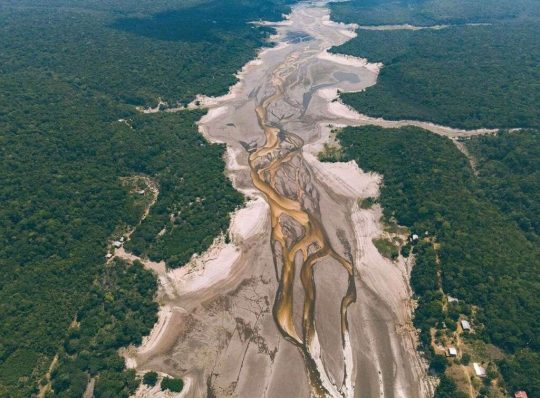
picture from Folha PE
there's a lot going on but I haven't seen much international buzz around this like there was when the forest was on fire (maybe because it's harder to shift the narrative to blame brazil exclusively as if the rest of the world didn't have fault in this) so I wanted to bring this to tumblr's attention
I don't know too many details as I live in the other side of the country and we are suffering from the exact opposite (at least three cyclones this year, honestly have stopped counting - it's unusual for us to get hit by even one - floods, landslides, we have a death toll, people are losing everything to the water), but like, I as a brazilian have literally never seen pictures of the river like this before. every single city in the amazonas state is in a state of emergency as of november 1st.
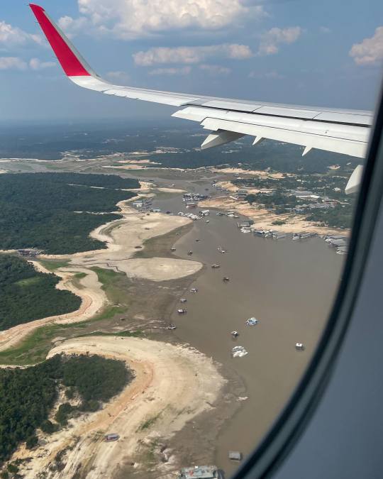
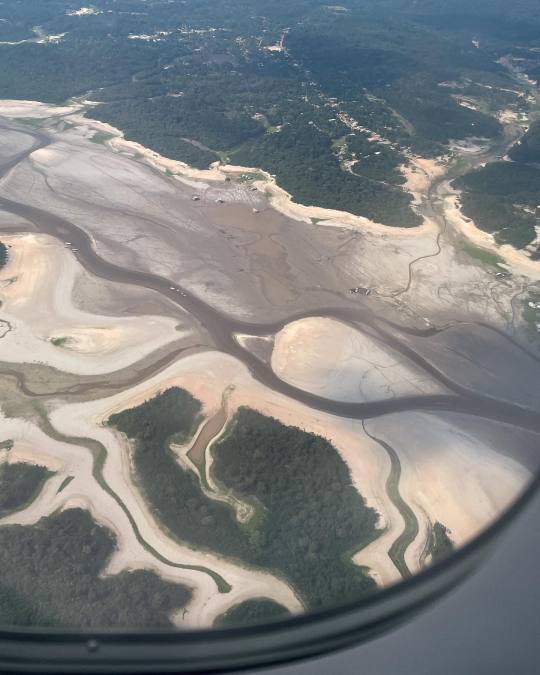
pictures by Adriano Liziero (ig: geopanoramas)
we are used to seeing images of rio negro and solimões, the two main amazon river affluents, in all their grandiose and beauty and seeing these pictures is really fucking chilling. some of our news outlets are saying the solimões has turned to a sand desert... can you imagine this watery sight turning into a desert in the span of a year?
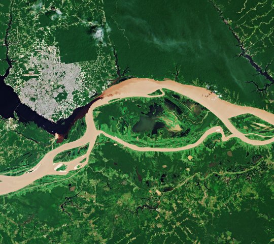
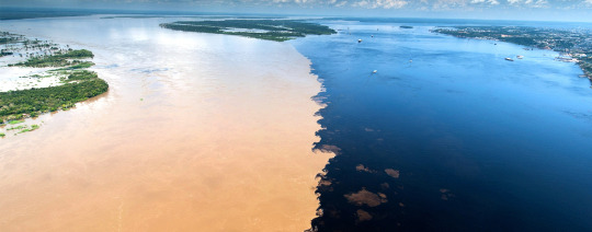
while down south we are seeing amounts of rain and hailstorms the likes of which our infrastructure is simply not built to deal with, up north people who have built everything around the river are at a loss of what to do.
the houses there that are built to float are just on the ground, people who depend on fishing for a living have to walk kilometers to find any fish that are still alive at all, the biodiversity there is at risk, and on an economic level it's hard to grasp how people from the northern states are getting by at all - the main means of transport for ANYTHING in that region is via the river water. this will impact the region for months to come. it doesnt make a lot of sense to build a lot of roads bc it's just better to use the waterway system, everything is built around or floats on the river after all. and like, the water level is so incomprehensibly low the boats are just STUCK. people are having a hard time getting from one place to another - keep in mind the widest parts of the river are over 10 km apart!!
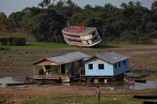
this shit is really serious and i am trying not to think about it because we have a different kind of problem to worry about down south but it's really terrifying when I stop to think about it. you already know the climate crisis is real and the effects are beyond preventable now (we're past global warming, get used to calling it "global boiling"). we'll be switching strategies to damage control from now on and like, this is what it's come to.
I don't like to be alarmist but it's hard not to be alarmed. I'm sorry that I can't end this post with very clear intructions on how people overseas can help, there really isn't much to do except hope the water level rises soon, maybe pray if you believe in something. in that regard we just have to keep pressing for change at a global level; local conditions only would not, COULD NOT be causing this - the amazon river is a CONTINENTAL body of water, it spans across multiple countries. so my advice is spread the word, let your representatives know that you're worried and you want change towards sustainability, degrowth and reduced carbon emissions, support your local NGOs, maybe join a cause, I don't know? I recommend reading on ecological and feminist economics though
however, I know you can help the affected riverine families by donating to organizations dedicated to helping the region. keep in mind a single US dollar, pound or euro is worth over 5x more in our currency so anything you donate at all will certainly help those affected.
FAS - Sustainable Amazon Fundation
Idesam - Sustainable Developent and Preservation Institute of Amazonas
Greenpeace Brasil - I know Greenpeace isn't the best but they're one of the few options I can think of that have a bridge to the international world and they are helping directly
There are a lot of other smaller/local NGOs but I'm not sure how you could donate to them from overseas, I'll leave some of them here anyway:
Projeto Gari
Caritás Brasileira
If you know any other organizations please link them, I'll be sure to reblog though my reach isn't a lot
thank you so much for reading this to the end, don't feel obligated to share but please do if you can! even if you just read up to here it means a lot to me that someone out there knows
also as an afterthought, I wanted to expand on why I think this hasn't made big news yet: because unlike the case of the 2020 forest fires, other countries have to hold themselves accountable when looking at this situation. while in 2020 it was easier to pretend the fires were all our fault and people were talking about taking the amazon away from us like they wouldn't do much worse. global superpowers have no more forests to speak of so I guess they've been eyeing what latin america still has. so like this bit of the post is just to say if you're thinking of saying anything of the sort, maybe think of what your own country has done to contribute to this instead of blaming brazil exclusively and saying the amazon should be protected by force or whatever
#solarpunk#sustainability#environmentalism#climate change#climate crisis#global warming#amazon rainforest#amazon river#geography#brazil#degrowth#punk#global boiling#ecopunk#anti capitalism#climate action#climate activism#the world does not die on my watch#i saw someone use that tag and uh i like it we should make it a thing#long post#:/ sorry i know no one likes lengthy bad news posts on their dashes but i've been thinking about this quite a bit#and i don't really know what to do to help bc i don't have money to donate and i am 10 thousand km away#i think i could be doing more to help but i am already trying my best#again dont feel obligated to share or read this but it would be nice and i would love you forever#have removed lbv from the post
7K notes
·
View notes
Text
Okay so the other day I was taken aback by how many countries* the world's most populous cities were bigger than so I started researching some more and GET THIS!
There are 32 cities with a population greater than 10 million - if you live in one of these, your city has a bigger population than 114 countries.
There are 83 cities with a population greater than 5 million - if you live in one of these, your city has a bigger population than 84 countries.
There are 255 cities with a population greater than 2 million - if you live in one of these, your city has a bigger population than 59 countries.
There are 574 cities with a population greater than 1 million - if you live in one of these, your city has a bigger population than 49 countries.
Idk to me that's just fascinating!
*One of the 210 places listed on the website I used to work this all out.
0 notes
Text
Fact of the day
There is a city called Rome (or Roma) on every continent
#fun facts#this fact was brought to you by libra pads#fact of the day#you know. because the british colonized everything and so they named a lot of towns after the “eternal city” in Italy#every continent--except Antartica#but not every town called Rome or Roma is named after the city#like the one in Australian is named after Lady Diamantina Bowen (née di Roma) the wife of the Qld Governor at the time#and there are apparently 13 Romes in the US#and apprently 35 around the world#Rome#Roma#world geography
0 notes
Text
Agreement over Berbera port between Somaliland and Ethiopia
Context: Ethiopia has struck a historic deal to use Somaliland’s Berbera port in the breakaway region of Somaliland for shipping. About Berbera Port Berbera Port is located in the Gulf of Aden. Berbera is considered to be the commercial capital of Somaliland. The deal will give Ethiopia access to the Red Sea, Gulf of Aden and the Suez Canal. Ethiopia is Africa’s second largest populated…

View On WordPress
0 notes