#Wasco Oregon
Explore tagged Tumblr posts
Visit Tumblr Blog
Explore Tumblr blogs with no restrictions, modern design and the best experience.
Last Seen Tumblr Blogs


Fun Fact
Tumblr is used by 21% of adults online aged 18-29 years.
Text
Wasco, Oregon: A Frontier Town with Deep Roots
#Historic Communities#OregonTrail#ShermanCounty#WheatFarming#WindEnergy#Frontier Towns#oregon history#Rura lResilience#SmallTown Life#Wasco Oregon
1 note
·
View note

Text

Columbia Gorge, Mt. St. Helens hiding in clouds, near Mosier, Oregon, 1998.
#landscape#river#horde#vulcanism#columbia gorge#wasco county#oregon#1998#photographers on tumblr#pnw#pacific northwest
9 notes
·
View notes
Text

June 30, 2024 | 182/365
3 notes
·
View notes
Text

Deschutes River State Recreation Area, Wasco, Oregon, USA
Eric Muhr
#Deschutes River State Recreation Area#Wasco#Oregon#USA#ORNature#US#United States#United States of America#North America
0 notes
Text
Morning sun on a Central Oregon cemetery...
Mt. Hood to the West.
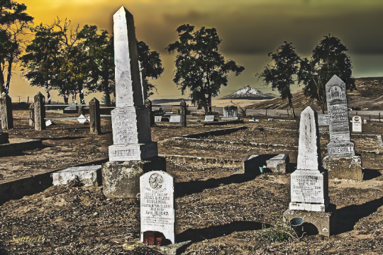
View On WordPress
0 notes
Text
U.S. daily high temperature records tied/broken 1/11/2025
Anchorage, Alaska: 42 (previous record 40 1989) Bettles, Alaska: 29 (also 29 1985) Caribou Peak summit, Alaska: 35 (also 35 2003) Chena River Recreation Area, Alaska: 36 (also 36 1984) Unincorporated Chugach Census Area, Alaska: 48 (also 48 1931) Unincorporated Copper River Census Area, Alaska: 38 (previous record 34 1989) Unincorporated Copper River Census Area, Alaska: 39 (previous record 36 1949) Fairbanks, Alaska: 31 (also 31 1985) Unincorporated Fairbanks North Star Borough, Alaska: 40 (previous record 31 1997) Unincorporated Fairbanks North Star Borough, Alaska: 37 (previous record 0 1997) Unincorporated Fairbanks North Star Borough, Alaska: 42 (previous record 37 1984) Unincorporated Fairbanks North Star Borough, Alaska: 35 (previous record 0 1997) Unincorporated Fairbanks North Star Borough, Alaska: 41 (previous record 39 1997) Kenai National Wildlife Refuge, Alaska: 41 (also 41 2016) Unincorporated Kodiak Island Borough, Alaska: 46 (previous record 45 2012) Unincorporated Matanuska-Susitna Borough, Alaska: 45 (also 45 1997) Noatak National Preserve, Alaska: 33 (previous record 30 2024) Unincorporated Nome Census Borough, Alaska: 34 (previous record 0 2007) North Pole, Alaska: 30 (previous record 29 2021) Pelican, Alaska: 42 (also 42 2016) Unincorporated Southeast Fairbanks Census Area, Alaska: 40 (previous record 33 2021) Unincorporated Southeast Fairbanks Census Area, Alaska: 30 (previous record 24 2021) Unincorprated Southeast Fairbanks Census Area, Alaska: 41 (previous record 35 1984) Yakutat, Alaska: 47 (previous record 46 1981) Unincorporated Yukon-Koyukuk Census Area, Alaska: 13 (previous record 11 2015) Unincorporated Kings County, California: 70 (previous record 66 2015) Oakland, California: 71 (previous record 68 1983) San José, California: 69 (also 69 1959) San Rafael, California: 69 (also 69 1953) Unincorporated Tulare County, California: 72 (also 72 1959) Unincorporated Tuolumne County, California: 67 (also 67 2012) Wasco, California: 76 (previous record 74 2018) Wake Island, Marshall Islands: 87 (also 87 2002) Sand Island, Midway Atoll: 77 (previous record 76 1988) Deschutes National Forest, Oregon: 42 (previous record 41 2009) Mt. Rainier National Park, Washington: 50 (previous record 49 2010)
2 notes
·
View notes
Photo

Weather: Pacific Northwest
Report generated at 2024-12-06 20:00:07.175413-08:00 using satellite imagery and alert data provided by the National Weather Service.
Winter Weather Advisory
WA:
Central Chelan County
Kittitas Valley
Lower Slopes of the Eastern Washington Cascades Crest
Moses Lake Area
Northeast Mountains
Northern Blue Mountains of Oregon
Northern Panhandle
Northwest Blue Mountains
Okanogan Highlands
Okanogan Valley
Spokane Area
Upper Columbia Basin
Upper Slopes of the Eastern Washington Cascades Crest
Waterville Plateau
Wenatchee Area
West Slopes South Central Cascades and Passes
Western Okanogan County
OR:
Lower Treasure Valley
Malheur County
Northern Blue Mountains of Oregon
Northwest Blue Mountains
Oregon Lower Treasure Valley
ID:
Bitterroot/Sapphire Mountains
Lower Hells Canyon/Salmon River Region
Lower Treasure Valley
Malheur County
Northeast Mountains
Northern Clearwater Mountains
Northern Panhandle
Oregon Lower Treasure Valley
Orofino/Grangeville Region
Southern Clearwater Mountains
Winter Storm Warning
WA:
West Slopes North Cascades and Passes
West Slopes North Central Cascades and Passes
Western Chelan County
Flood Watch
WA:
Mason
Air Stagnation Advisory
WA:
Cascade Foothills of Marion and Linn Counties
Central Oregon Coast Range Lowlands
Clackamas County Cascade Foothills
Cowlitz County Lowlands
East Central Willamette Valley
Inner Vancouver Metro
Lane County Cascade Foothills
Lower Columbia River
North Clark County Lowlands
North Oregon Coast Range Lowlands
Outer Southeast Portland Metro
South Washington Cascade Foothills
Tualatin Valley
West Central Willamette Valley
Willapa and Wahkiakum Lowlands
OR:
Baker County
Benton County Lowlands
Boise Mountains
Camas Prairie
Cascade Foothills of Marion and Linn Counties
Central Douglas County
Central Oregon Coast Range Lowlands
Central and Eastern Lake County
Clackamas County Cascade Foothills
Cowlitz County Lowlands
East Central Willamette Valley
Eastern Curry County and Josephine County
Harney County
Jackson County
Klamath Basin
Lane County Cascade Foothills
Lane County Lowlands
Linn County Lowlands
Lower Columbia River
Lower Treasure Valley
Malheur County
North Clark County Lowlands
North Oregon Coast Range Lowlands
Northern and Eastern Klamath County and Western Lake County
Oregon Lower Treasure Valley
Outer Southeast Portland Metro
South Washington Cascade Foothills
Tualatin Valley
Upper Treasure Valley
Upper Weiser River
West Central Mountains
West Central Willamette Valley
Western Magic Valley
Willapa and Wahkiakum Lowlands
ID:
Baker County
Boise Mountains
Camas Prairie
Harney County
Lower Treasure Valley
Malheur County
Oregon Lower Treasure Valley
Upper Treasure Valley
Upper Weiser River
West Central Mountains
Western Magic Valley
Freezing Fog Advisory
OR:
North Central Oregon
CA:
Lassen-Eastern Plumas-Eastern Sierra Counties
Northern Washoe County
NV:
Lassen-Eastern Plumas-Eastern Sierra Counties
Northern Washoe County
Wind Advisory
OR:
Grande Ronde Valley
CA:
Santa Susana Mountains
Dense Fog Advisory
OR:
Lower Treasure Valley
Oregon Lower Treasure Valley
Upper Treasure Valley
Upper Weiser River
ID:
Bear Lake Valley
Lower Treasure Valley
Oregon Lower Treasure Valley
Upper Treasure Valley
Upper Weiser River
CA:
Bakersfield
Buttonwillow - Lost Hills - I5
Caruthers - San Joaquin - Selma
Delano-Wasco-Shafter
Fresno-Clovis
Hanford - Corcoran - Lemoore
Los Banos - Dos Palos
Merced - Madera - Mendota
South End San Joaquin Valley
Southeast San Joaquin Valley
Visalia - Porterville - Reedley
West Side of Fresno and Kings Counties
Air Quality Alert
OR:
Lake
CA:
Calabasas and Agoura Hills
Catalina and Santa Barbara Islands
Eastern San Fernando Valley
Eastern Santa Monica Mountains Recreational Area
Los Angeles County Beaches
Los Angeles County Inland Coast including Downtown Los Angeles
Los Angeles County San Gabriel Valley
Malibu Coast
Palos Verdes Hills
Santa Clarita Valley
Santa Susana Mountains
Western San Fernando Valley
Western Santa Monica Mountains Recreational Area
Fire Weather Watch
CA:
Calabasas and Agoura Hills
Central Ventura County Valleys
Eastern San Fernando Valley
Eastern San Gabriel Mountains
Eastern Santa Monica Mountains Recreational Area
Interstate 5 Corridor
Los Angeles County San Gabriel Valley
Malibu Coast
Northern Ventura County Mountains
Riverside County Mountains-Including The San Jacinto Ranger District Of The San Bernardino National Forest
San Bernardino County Mountains-Including The Mountain Top And Front Country Ranger Districts Of The San Bernardino National Forest
San Bernardino and Riverside County Valleys - The Inland Empire
San Diego County Inland Valleys
San Diego County Mountains-Including The Palomar And Descanso Ranger Districts of the Cleveland National Forest
San Gorgonio Pass Near Banning
Santa Ana Mountains-Including The Trabuco Ranger District of the Cleveland National Forest
Santa Clarita Valley
Santa Susana Mountains
Southeastern Ventura County Valleys
Southern Ventura County Mountains
Ventura County Beaches
Ventura County Inland Coast
Western San Fernando Valley
Western San Gabriel Mountains and Highway 14 Corridor
Western Santa Monica Mountains Recreational Area
2 notes
·
View notes
Text
Coming This October On FishRPG...
Somewhat surprisingly, the dice have demanded that I revisit the western aesthetic after only a month. Though instead of a weird west, I'm going to be focusing on a more historical western without magic. And I'm also going to be switching things up and focusing on fleshing out pieces of a singular fictional settlement instead of doing a broader area of larger areas. After much consultation with the dice, let me introduce you to
The Town of Bowman
Bowman is a frontier town in southern Oregon, right on the border with California. It was founded in 1852 back when the area was still the Oregon Territory. It was founded as hub for emigrants who were leaving Oregon and flocking to the Applegate Trail during the California Gold Rush.
Geographically, the town is on the Klamath River, just southwest of where Altamont would be located a few years later. The town would eventually fail and its population would relocate to Altamont and Klamath Falls, though this didn't happen until the turn of the 20th century. For setting purposes, the version of Bowman I'm looking at is how it would have looked during 1872-1873. During this specific time frame, Bowman is located in Wasco county, though that specific area will be reassigned as Lake County in 1874 and eventually turn into Klamath County in 1882.
Bowman's economy is at an inflection point during this period; its primary industry has been harvesting timber from ponderosa pines, but the clear cut areas have now given way to a thriving cattle ranching community. Exceptionally harsh winters in 1879 and 1889 would eventually destroy cattle operations, hastening the town's decline.
Rail activity in the area predates the Transcontinental Railroad. Currently the town is served by a branch line that connects to the larger Oregon and California (O&C) Railroad. The branch line runs east-west, bisecting the town.
To the north of Bowman is the Klamath Indian Reservation, established in 1864. The Reservation is home to three tribes: Klamath, Modoc, and the Yahooskin Band of Northern Paiute Indians. Unfortunately, the town's location puts it the crossfire of a conflict known as the Modoc War that is currently ongoing.
------------
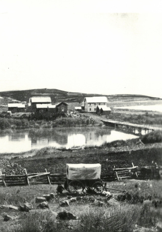
Header image taken from the Oregon Encyclopedia, and depicts George Nurse's home in Linkville, which would eventually become Klamath Falls.
2 notes
·
View notes
Text

Deschutes River State Recreation Area, Wasco, Oregon. Photo by Eric Muhr @ericmuhr
#rvlife#camping#rv living#adventure#traveling#rvadventures#travel#campfire#rvliving#travel photography#vanlove#vanliving#vanlife#rv camping#rv life#oregon
3 notes
·
View notes
Text
OSP ASKING FOR THE PUBLIC'S HELP TO LOCATE WANTED MAN
Suspect wanted for sex crimes in Oregon and Alabama
WASCO COUNTY, Ore. 9 Sept. 2024 – Oregon State Police and the Mobile (Alabama) Police Department are seeking the public’s help to locate Adam Renk (39) who is wanted in both states for sex crimes against child victims.
On June 21, 2024, OSP detectives responded to a sexual abuse disclosure made by a child. The child disclosed Renk as the perpetrator. Renk has since been indicted on multiple crimes against a child victim under the age of 12. He is charged with Unlawful Sexual Penetration in the First Degree, Sodomy in the First Degree, and Sexual Abuse in the First Degree.
As part of their investigation, OSP detectives learned Renk had been charged in another case involving a minor victim in Mobile, Alabama. The Alabama charges include Child Sexual Abuse and Torture involving an 11-year-old victim. The victims in the two states are not related. Alabama law enforcement agencies and the U.S. Marshals Service are attempting to locate Renk who posted bond in Alabama and was released from pre-trial custody.
Renk was last seen leaving Alabama on August 7, 2024. He has ties to Oregon and Wasco County. He is believed to be traveling in a converted Ford Ambulance that is now painted two-toned white over gray. Renk is a white male, 6 ft. 1 in. tall, 175 pounds, with blue eyes and brown hair.
Anyone with information about Renk’s whereabouts or information about possible additional victims is asked to contact the Wasco County Sheriff’s Office at 541-506-2580 or OSP Detective Cassie Bantz through dispatch at 800-442-0776 or by dialing *OSP (*677) on a mobile phone.
1 note
·
View note
Text
POSTCARDS AS COMMUNIQUES When Indigenous history gets overlooked, ignored
[The Wasco and Wishram lived along what is now called Hood River in Oregon, and lost their territory to settlers in the 1800s. Edward S. Curtis captured an image of a Wishram girl in 1909. Photo from the Library of Congress, in the Public Domain.] A Postcard Tradition Picture postcards in the US have long presented an affordable way to share beach vacations with relatives, and offer a quick…

View On WordPress
0 notes
Text


Deschutes River State Recreation Area, Wasco, Oregon, USA
Eric Muhr
#Deschutes River State Recreation Area#Wasco#Oregon#USA#US#United States#United States of America#North America#ORNature
0 notes
Text
Wind turbine hub: oily dirt and missing nose cone
(image archive) Vestas 1.65-megawatt wind turbine, missing its nose cone, at Portland General Electric’s Biglow Canyon wind farm in Wasco County, Oregon, 2022 - Photographer: Dave Killen/The Oregonian https://www.wind-watch.org/pix/displayimage.php?pid=977
0 notes
Text
Three-Fingered Jack (2/3)
Because of (relatively) short distances and long days, this was the rare backpacking trip where I didn't need to set an alarm for morning. Instead, I woke up the same way I do on most alarm-less trail days: screaming while melting alive in my tent a half-hour or so after sunrise.
Fortunately, outside the tent the air was still cool, and, as is usually the case in the western high country, nearby shady patches dropped the temperature another twenty degrees or so. I set up to make breakfast in one such shady patch while watching the sun light up Three-Fingered Jack's craggy face.

I was on my way back down the scramble trail to the meadows shortly after waking up. My main worry before the trip had been navigating this trail going downhill with a pack on: I remembered there being a lot of loose scree on my 2021 descent, and I worried that the extra weight on my back this time would make it not just slippery, but legitimately dangerous. As it turned out, though, this was all a matter of route choice: I was able to avoid the loosest parts of the descent simply by being a bit more careful about picking my way down than I'd been last time (and with the help of a few mountain goats who were napping in the sun near the top of the route, which forced me to climb a little lower to avoid disturbing them).
Below, in the meadow, the rest of my goat fam was waking up. I was hesitant to take the established trail too close to them, especially because there were a lot of baby goats in the group, but in the end I passed by carefully and slowly, and though the adults very clearly kept themselves interposed between me and the babies, they never seemed particularly agitated by my passage.
Mountain goats are quite possibly my favorite animal on earth, and so for me this was a moment the kids these days would (incorrectly) call "a core memory."
Pedantry aside, though, it was freaking awesome.
Once back on the trail, it was a straightforward hike back out of Canyon Creek Meadows and back to the main trail. I was sad to leave such a beautiful place (and the goats!), but the trail provides some amazing parting views of the mountain...and I certainly wasn't done with Three-Fingered Jack yet.

As you leave Canyon Creek, there are actually two trails you can take: I'd taken the sparser, southern one in from Jack Lake the previous day, but I took the northerly, more forested one on the way out, both for the sake of variety and because it saved me a little distance on the way to my next goals: Wasco Lake and Minto Pass.
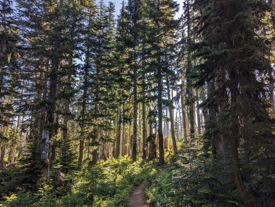
Maybe it was just because I knew that I was heading back into the burn, but the last, heavily forested section of the meadows trail seemed particularly gorgeous in the morning light.
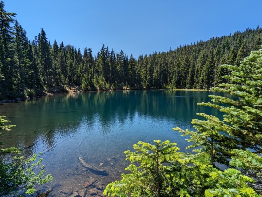
It's not actually that far of a hike from this trail intersection to Wasco Lake, but being out of the shade again, even in midmorning, reminded me that it was, in fact, going to be a very hot day.
Wasco Lake itself is great. It's snugged up nicely against a cliff face and circled by a bit of forest. It has a few excellent campsites, too, though they have already been occupied both times I've passed through, mid-week, likely because of the lake's proximity to the PCT. I like it just fine, I'm just not sure that I would ever choose to camp there knowing that Canyon Creek Meadows was only a few miles' walk away...

...sorry, Wasco Lake.
Minto Pass sounds more daunting than it is if you're used to scrambling around central Oregon mountains, but the slight climb deposits you up high on a ridge that provides some great, far-off-ish views of the mountain you're circling.

From here, the rest of my route would be on the PCT, heading south over Porcupine Rock and ultimately back to my car at Santiam Pass. I don't think there's anything in this second "side" of the hike that's nearly as gorgeous or evocative as Canyon Creek Meadows, but I still had a great time, and there are still a few notable sights worth mentioning.
The first few miles of hiking after the intersection with the PCT are all elevation gain. This is mostly burn territory as well (though there are a few little forested spots here and there), but for whatever reason it didn't feel as hot as the burn on the southeast side of the mountain did on the previous day. The "lack" of heat was more than made up for by the amount of blowdown on the trail through this section, though.
I tend not to complain much about blowdown, generally, for two reasons. First, I'm taller than most people, which usually (though not always!) makes navigating blowdown easier for me than for others. Second, most trails are cleared of blowdown by volunteer trail crews, or, at best, Forest Service employees who aren't paid enough for the backbreaking work they put in. With that in mind, whining about the fact that the trail is difficult to navigate because someone else hasn't fixed it for me feels a little...myopic, I guess?
All that said, the blowdown situation on this part of the trail was really bad. So it was slow going for a while. Thanks in advance to whoever clears this leg of the trail in the future!
Ultimately, I survived a few knee bruises and shin scratches to get to where the trail opens up and switchbacks upward to Porcupine Rock, the high point of Three-Fingered Jack's north shoulder. I love the views here, not just because they're expansive, but because you can also see back down into Canyon Creek Meadows from above, allowing you to see all the terrain you crisscrossed and camped in the night before. I even told myself that a few of the small white dots I saw among the grey rocks of the hills were mountain goats, though I didn't have any way to know for sure.

At the top of Porcupine Rock, I took a long break in a tiny patch of shade to eat and rehydrate, and then I started bombing downhill.
Downhill!
To be clear, I've very rarely ever disliked a section of trail I've hiked, but this loop post-Porcupine Rock definitely becomes less interesting, in my experience. You take the PCT south for seven more miles total, and though the views of the west side of the mountain are nice, and there are some pleasantly forested areas in contrast with the east side's burn, there's just something about this section that puts me in a "Push through and finish" state of mind. Maybe it's the vastly increased hiker traffic compared to the east side because of the PCT. Maybe it's just the knowledge that I'm almost done with the hike. Regardless, I tend to rush through this part, but it's not without it's beauty, especially once you get far enough around Three-Fingered Jack to start getting views of the surrounding lakes and (again) the Sisters and Mount Washington in the distance.


Technically, I had enough daylight to push on all the way to Santiam Pass and the car at this point, but I'd packed for two nights of camping, and had hoped to be able to find the elusive Summit Lake, a lake that I'd read a bunch about online before my 2021 trip, but somehow failed to find the spur trail to during that trip, necessitating a long day (and night) of hiking beyond what I'd planned that doesn't really deserve describing in detail here.
Fortunately, on this second and more recent try, I was able to both find the spur trail to Summit Lake and better understand why I'd missed it the first time. Basically, a huge tangle of blowdown that happened to fall right at the point where the spur trail leaves the PCT makes it difficult to find it at first, but by staying up high and pushing through the bush a bit, I was able to eventually spot the trail below me and drop down onto it.
Summit Lake was much more beautiful that I expected a somewhat tiny, somewhat random lake nestled in the shoulder of Three-Fingered Jack to be.
I got there around 1:30pm, too, which is about six hours earlier than I roll into camp on a normal day of hiking. I had time to compass the whole lake in search of the "perfect" camp spot, spread out my gear, rinse out some of my hiking clothes (and socks), take a swim in the lake (which was amazing and amazingly cold) and eat lunch and read a bit...before a guided group of eleven teenagers showed up and took over the opposite side of the lake for the night.
In all honesty, they were about as well-behaved as you could imagine such a group being: they were goofy and loud pretty much all afternoon and night, but promptly got quiet around a "normal" bedtime and woke up after me in the morning. There's just something about a place like Summit Lake that makes me feel like I "should" have it all to myself, so I was a little disappointed when such a big group showed up. That's a problem with me, though, not the other hikers. It's public land, after all.
Anyway, another pretty decent sleep in the books, the next morning I would wake up to take a short hike back to the car but then spontaneously tackle another mountain before heading home...
0 notes