#Property surveying
Explore tagged Tumblr posts
Visit Tumblr Blog
Explore Tumblr blogs with no restrictions, modern design and the best experience.
Last Seen Tumblr Blogs


Fun Fact
12.7% of mobile users access Tumblr.
Text

0 notes
Text
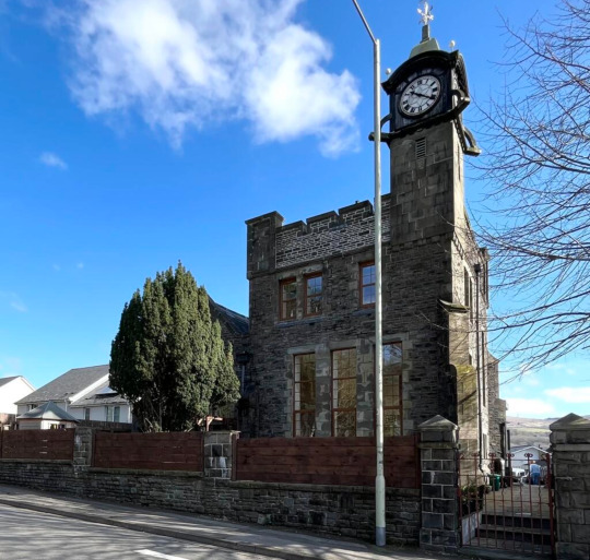
yo look at her that’s an actual house

#energy bills would be redonkulous#the size of those roooms#and no double glazing#nor would there ever be#cus bitch’ll be a listed building#our man on the inside#says it’s been put up every few months for over a year#when people buy and try to sell it again#which apparently is hard to do#cus in most of the property surveys#it’s found ‘structurally unsound’#and he reckons cash is exchanging hands#in order to successfully get it put on the market again#but freezing to death come winter if the thing doesn’t collapse first#surely small price to pay#for getting to be#the freaks who live in the clocktower#the freaks who live in the castle#the freaks who live in the combination clocktower and castle
20 notes
·
View notes
Text
why do "dangerous and functional train tracks that have killed a man" and "the federal government" and "large bodies of water that are notoriously polluted with dangerous objects" always have to keep me away from cool birds!
#/gen#i think if i run i can cross the train tracks#and i DOUBT there are any camera's surveying the government property#then again last time i assumed the cops weren't watxhing i ended up breaking the law directly next to a functional security camera#so i probably shouldnt do that again#three pigeons in a trench coat
6 notes
·
View notes
Text
not sure how many of you will see this but I wanted to see the trends of polls in tumblr. in the tags or comments I'd appreciate it if you could explain why you think you do this. if you did this I'd appreciate also doing this ones too.
#polls#my property#tumblr#tunglr#statistics#survey#i said i wasnt gonna it but i am weak#poll trends survey
29 notes
·
View notes
Text
Meta Geomatics Property Survey Company
A property survey company plays a crucial role in real estate transactions by providing comprehensive assessments of land and structures. These surveys offer invaluable insights into property boundaries, easements, encroachments, and other critical details essential for legal and development purposes.
Expert surveyors employ advanced technologies like GPS, drones, and 3D scanning to ensure accuracy and efficiency in their evaluations. Whether it's for residential, commercial, or industrial properties, these companies deliver detailed reports that aid in decision-making processes for buyers, sellers, and developers.
Moreover, property survey companies serve as guardians of property rights, helping clients navigate complex regulatory requirements and resolve disputes over land ownership or usage. By leveraging their expertise and cutting-edge tools, they contribute to the smooth functioning of real estate markets and the sustainable development of communities. In essence, partnering with a reputable property survey company is an indispensable step towards ensuring transparency, legality, and peace of mind in any property transaction.
#land survey company#land surveying company#Laser Scanning#Scan to BIM#3D Mapping#property survey company
2 notes
·
View notes
Text

Can't wait for some 50 year old land surveyor to get an uptick in calls from wooks trying to perform witchcraft.
#20 years from now I will be doing property corners and I'm going to find a bunch of heart shaped crystals and it will give me nam flashbacks#land surveying memes for obliterated trees#oh god they'll think their indigenous artifacts and we're going have to go through all that eeeeeeee#'I can't find the na- WHAT THE FUCK IS THIS?'
2 notes
·
View notes
Text
Exploring the Diverse Landscape of Surveys: Unveiling Different Types
Introduction Civil engineering, as a discipline, relies heavily on accurate and comprehensive data to design, plan, and construct various infrastructure projects. Surveys play a crucial role in gathering this essential information, providing engineers with the data needed to make informed decisions. There are several types of surveys in civil engineering, each serving a unique purpose. In this…

View On WordPress
#accurate measurements#as-built survey#boundary survey#civil engineering data#Civil engineering surveys#construction progress monitoring#construction survey#design accuracy#environmental monitoring#geodetic survey#global mapping#hydrographic survey#infrastructure development#infrastructure projects#land surveyor#legal boundaries#monitoring survey#project planning#property lines#structural integrity assessment#surveying in civil engineering#surveying innovations#surveying technology#topographic surveying#water body survey
2 notes
·
View notes
Text
2 notes
·
View notes
Text
How To Renovate A Period Property Without Losing Character
Period properties are immensely charming and exude character from top to bottom. If you’re planning on doing renovations, the last thing you’ll want to do is jeopardise this. Continue reading Untitled

View On WordPress
2 notes
·
View notes
Text

0 notes
Text
Comprehensive House Survey Services for Property Buy & Sell Cullinan Construction Consultant's expert team offers comprehensive house survey services, including building surveys, drone surveys, structural surveys, and property surveys. Benefit from RICS home surveys to ensure informed decisions in your property transactions. Visit our Website at:- www.cullinan-uk.com and Contact at:- +44 333 7722799
#architects in coventry#house of the dragon#architects in shrewsbury#the umbrella academy#architects in telford#architects in walsall#building survey#drone survey#house survey#property survey
0 notes
Text
not sure how many of you will see this but I wanted to see the trends of polls in tumblr. if you have anything else to add, I'd appreciate it if you wrote it in the tags or comments. if you did this I'd appreciate also doing this ones too.
28 notes
·
View notes
Text
How Long Does It Take to Complete a Land Survey in Tampa?
If you're planning a land survey in Tampa, one of your first questions is probably, “How long will it take?” Land surveys are crucial for defining property boundaries, resolving disputes, and preparing for construction projects. The time it takes to complete a survey depends on several factors, including the property size, the type of survey, and any unique challenges the land presents.

What Is a Land Survey?
A land survey is a detailed evaluation of a property that defines boundaries, identifies features, and provides critical data for legal and construction purposes. Surveyors use advanced tools like GPS, drones, and total stations to gather precise measurements.
Key Elements of a Land Survey
Boundary Identification: Pinpointing where your property starts and ends.
Feature Mapping: Documenting natural and man-made features like trees, slopes, or structures.
Legal Documentation: Preparing reports and maps that meet state and local requirements.
Land surveys are particularly important in Tampa because of the city’s mix of coastal, urban, and residential landscapes. These surveys help homeowners, developers, and businesses make informed decisions.
Factors That Affect the Timeline of a Land Survey
The time it takes to complete a land survey in Tampa can vary based on several factors. Understanding these elements will give you a better idea of what to expect.
1. Size and Complexity of the Property
Larger properties naturally take longer to survey than smaller ones. Complex features, such as uneven terrain, dense vegetation, or water bodies, can also increase the time needed for a survey.
Examples
Small Residential Lot: Typically takes 1–3 days.
Larger Rural Property: This may require up to a week or more, especially if the land is heavily wooded.
Commercial Properties: Complex layouts with existing structures can add days to the timeline.
Tampa's surveyors are familiar with navigating diverse property types, but larger or more complex jobs always require additional time.
2. Type of Survey Required
The type of survey you need also significantly influences the length of the process. Some surveys require more detailed measurements or legal documentation than others.
Common Types of Land Surveys
Boundary Surveys: Focus on defining property lines. These are typically faster and take 1–3 days.
Topographic Surveys: Include elevation and feature mapping, which can take 3–7 days.
ALTA/NSPS Surveys: Commercial real estate transactions require detailed legal and zoning information. These can take 2–3 weeks.
Understanding the type of survey needed for your project is essential for setting realistic expectations about the timeline.
3. Permits and Legal Research
Surveyors must often research property records, deeds, and permits to ensure accuracy. In Tampa, this step can take additional time, especially if the property has a complicated history.
Why Research Matters
Historical Boundaries: Older properties may have outdated records that must be verified.
Easements and Restrictions: Surveyors must account for legal easements, such as utility access.
Compliance: Ensures the survey meets Florida’s legal requirements.
While research might add a few days to the process, it’s essential for producing a reliable and accurate survey.
How You Can Help Speed Up the Process
While some factors are out of your control, there are steps you can take to make the survey process more efficient.
Tips for Property Owners
Provide Documentation: Share any existing surveys, deeds, or records you have.
Clear the Land: Remove debris, overgrown vegetation, or other obstacles that could slow down the surveyor.
Mark Property Corners: If you know the approximate location of your property lines, marking them can save time.
Preparing beforehand can help your surveyor work more quickly and efficiently.
Why Land Surveys Are Essential in Tampa
Land surveys aren’t just a legal formality—they’re a critical part of property ownership and development in Tampa. The city’s unique geography, growing population, and strict building codes make accurate surveys indispensable.
Common Scenarios Requiring Land Surveys
Buying or Selling Property: Ensures that the property boundaries are clearly defined.
Construction Projects: Prevents building on the wrong side of a property line.
Resolving Disputes: Provides legal clarity in boundary disagreements.
By investing in a professional land survey, you can protect your property and ensure compliance with Tampa’s regulations.
Choosing the Right Surveyor in Tampa
Selecting a qualified surveyor ensures your project runs smoothly and on time. Here’s what to look for:
What to Consider
Experience: Choose a surveyor with a strong track record in Tampa.
Licensing: Verify that they’re licensed and certified in Florida.
Reputation: Check online reviews or ask for referrals from friends or colleagues.
A reputable surveyor will communicate, provide accurate estimates, and deliver high-quality results.
Final Thoughts
Completing a land survey in Tampa is vital to property ownership, construction, and development. While the timeline varies depending on property size, survey type, and research needs, most surveys can be completed within a few days to a few weeks.
Understanding the process and preparing beforehand can ensure a smooth and efficient experience. Whether buying land, starting a construction project, or resolving a property dispute, a land survey provides the clarity and confidence you need to move forward.
0 notes
Text
Get long-term solutions for your emergency blocked drains in Highgate.

It helps to identify blockages, detect structural issues, prevent future problems, pinpoint leaks, and ensure that your drainage system complies with regulations. You should hire a certified drainage company to inspect the condition of your drainage infrastructure. Professionals assisting with CCTV drain surveys in Walthamstow use specialized equipment and techniques to check the condition of your drainage system.
#CCTV drain surveys in Walthamstow#CCTV drain survey in Camden#emergency blocked drains in Walthamstow#emergency blocked drains in Highgate#ABS Property Services
0 notes