#geodetic survey
Explore tagged Tumblr posts
Visit Tumblr Blog
Explore Tumblr blogs with no restrictions, modern design and the best experience.
Last Seen Tumblr Blogs


Fun Fact
Tumblr was the first site to host the blog for President Barack Obama in 2011.
Text
Exploring the Diverse Landscape of Surveys: Unveiling Different Types
Introduction Civil engineering, as a discipline, relies heavily on accurate and comprehensive data to design, plan, and construct various infrastructure projects. Surveys play a crucial role in gathering this essential information, providing engineers with the data needed to make informed decisions. There are several types of surveys in civil engineering, each serving a unique purpose. In this…

View On WordPress
#accurate measurements#as-built survey#boundary survey#civil engineering data#Civil engineering surveys#construction progress monitoring#construction survey#design accuracy#environmental monitoring#geodetic survey#global mapping#hydrographic survey#infrastructure development#infrastructure projects#land surveyor#legal boundaries#monitoring survey#project planning#property lines#structural integrity assessment#surveying in civil engineering#surveying innovations#surveying technology#topographic surveying#water body survey
2 notes
·
View notes
Text
Earlier this year my partner and I climbed Mount Sunday, the filming location for Edoras in The Lord of the Rings. At the very top of it was this:
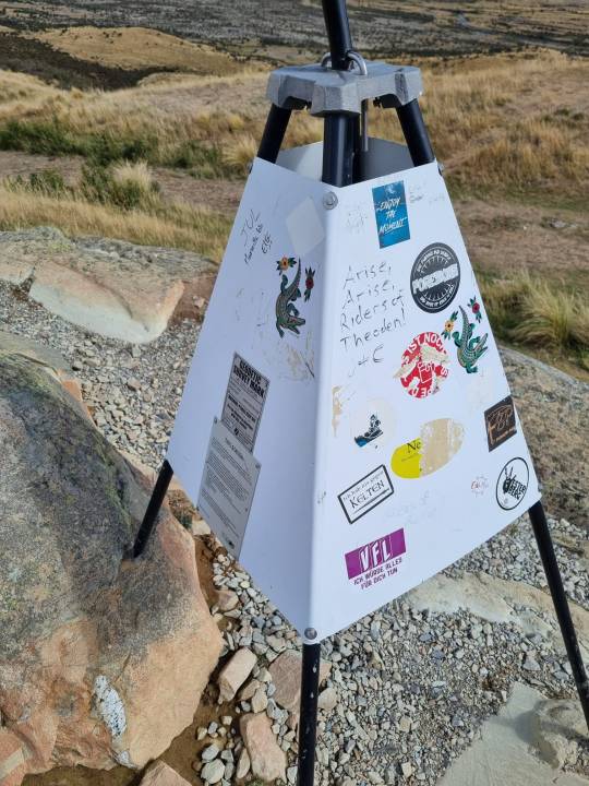
#rest in peace#bernard hill#LOTR#lord of the rings#edoras#that thing is a geodetic survey mark#which are apparently scattered around new zealand to mark the location/ altitude of various bits of landscape
8 notes
·
View notes
Text
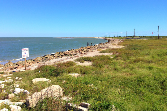
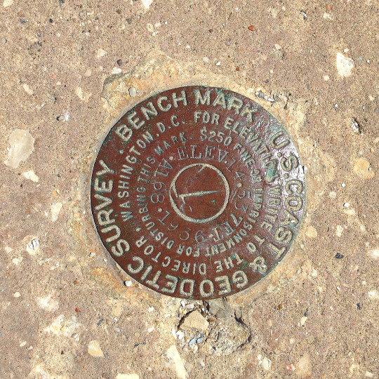
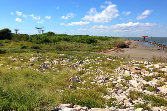
U.S. Coast & Geodetic Survey Benchmark, Galveston. Elev 14.53 ft. A168 1936.
For elevation write to the director - Washington, D.C. $250 fine or imprisonment for disturbing this mark.
0 notes
Text
Check Out Survey Services | AABSyS
Check out AABSyS Survey Services to increase your data insights. Identify pertinent information and make informed decisions. Learn more right now.
#construction survey drafting services#road data capture services#geodetic data survey services#manual survey services
0 notes
Text
So there’s something called a ‘geodetic control point.’ These are used by surveyors to create accurate map measurements. There’s over a million in the United States, which the National Geodetic Survey uses to ensure the government’s maps are all accurate. It’s extremely important that these things are more accurate than any measurement you do on top of it, so they’re usually extremely stable markers. Most of the time it’s metal caps or rods buried in the ground

Washington D.C. has a couple of them, of course.
Next to the Washington Monument is a manhole cover in the grass.
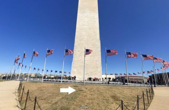
That manhole does not lead to a sewer - it’s the top of a control point. But unlike most control points that are simple rods, this one is unique…
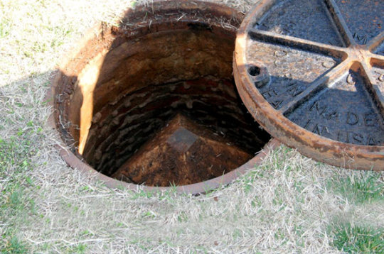
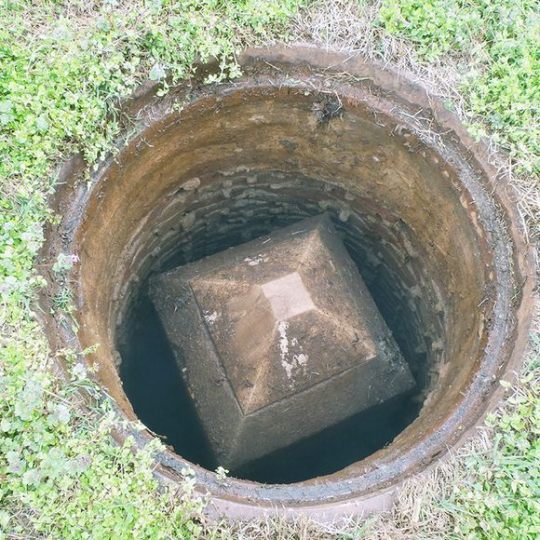
… for this control point is a mini replica of the Washington monument buried right next to the full size one.
3K notes
·
View notes
Link
Jual Gps Geodetic Hi Target GNSS RTK iRTK-5 Di Distributor Indonesia
0 notes
Photo

#surveyor hat, precision meet the wild
1 note
·
View note
Text

In addition to 'squishy', after reviewing my submitted intraplate ground motion data, the National Geodetic Survey has politely asked me to stop using the word 'supple' so often when describing Midwestern states.
Minnesota [Explained]
Transcript
[Hairy standing in front of Ponytail and Cueball, who are sitting behind a desk] Hairy: Does anyone have any other concerns? Cueball: I'm concerned that Minnesota is getting shorter.
[A map of Minnesota beside Cueball, with arrows pointing from the northern and southern borders towards the middle] Cueball: Because of post-glacial crust rebound, the northern border is moving toward the southern border. It's less than an inch a decade, but I still don't like it. Cueball: Minnesota shouldn't be squishy.
[Hairy again standing in front of Ponytail and Cueball at the desk. Ponytail is looking at Cueball, whose finger is now raised in the air, gesturing] Hairy: Okay. Does anyone have any concerns related to the topic of this meeting? Cueball: All meetings should be about Minnesota until we resolve this.
557 notes
·
View notes
Text
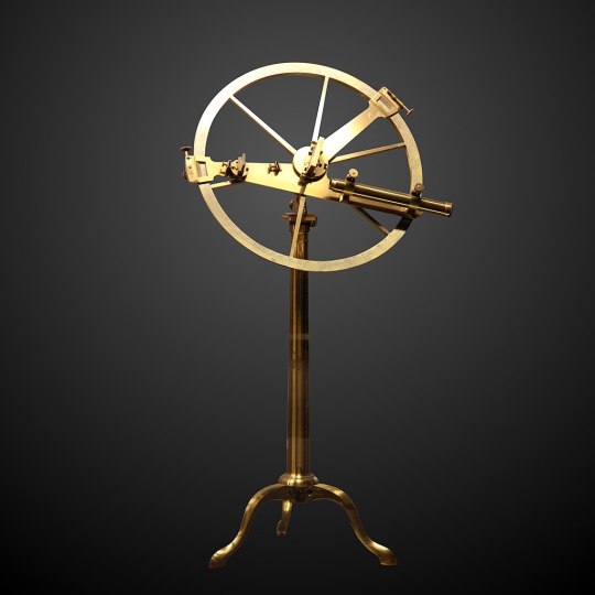
Reflecting circles
The reflecting circle was invented by the German geometer and astronomer Tobias Mayer in 1752, with details published in 1767. His development preceded the sextant and was motivated by the need to create a superior surveying instrument.
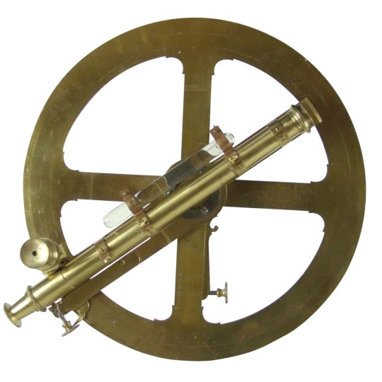
A Mayer circle, 18th century
It is a complete circular instrument graduated to 720° (to measure distances between heavenly bodies, there is no need to read an angle greater than 180°, since the minimum distance will always be less than 180°). Mayer presented a detailed description of this instrument to the Board of Longitude and John Bird used the information to construct one sixteen inches in diameter for evaluation by the Royal Navy. This instrument was one of those used by Admiral John Campbell during his evaluation of the lunar distance method. It differed in that it was graduated to 360° and was so heavy that it was fitted with a support that attached to a belt. It was not considered better than the Hadley octant and was less convenient to use. As a result, Campbell recommended the construction of the sextant.
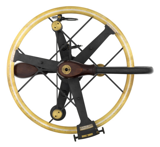
Jean-Charles de Borda further developed the reflecting circle. He modified the position of the telescopic sight in such a way that the mirror could be used to receive an image from either side relative to the telescope. This eliminated the need to ascertain that the mirrors were precisely parallel when reading zero. This simplified the use of the instrument. Further refinements were performed with the help of Etienne Lenoir. The two of them refined the instrument to its definitive form in 1777. This instrument was so distinctive it was given the name Borda circle or repeating circle. Borda and Lenoir developed the instrument for geodetic surveying. Since it was not used for the celestial measures, it did not use double reflection and substituted two telescope sights. As such, it was not a reflecting instrument. It was notable as being the equal of the great theodolite created by the renowned instrument maker, Jesse Ramsden.
A Jean-Charles de Borda circle, by Étienne Lenoir 1775
Josef de Mendoza y Ríos redesigned Borda's reflecting circle in 1801. The goal was to use it together with his Lunar Tables published by the Royal Society. He made a design with two concentric circles and a vernier scale and recommended averaging three sequential readings to reduce the error. Borda's system was not based on a circle of 360° but 400 grads (Borda spent years calculating his tables with a circle divided in 400°). Mendoza's lunar tables have been used through almost the entire 19th century. Edward Troughton also modified the reflecting circle. He created a design with three index arms and verniers. This permitted three simultaneous readings to average out the error.
A Troughton Circle, 1803
As a navigation instrument, the reflecting circle was more popular with the French navy than with the British.
M. Daumas, Scientific Instruments of the Seventeenth and Eighteenth Centuries and Their Makers, London 1989
William Edward May, A History of Marine Navigation, G. T. Foulis & Co. Ltd., Oxfordshire, 1973
Richard, Dunn, Navigational Instruments, London 2016
79 notes
·
View notes
Text
Field Notes: NOAA Corps & MIDCON-RED
The smallest uniformed service in the United States, the NOAA Corps was created in 1970 as a direct successor to the Environmental Science Services Administration Corps and the Geodetic Survey Corps. The NOAA Corps legacy and relation to MIDCON-RED remains contentious, due to the lasting consequences of the Nixon administration and an interagency battle that still rages today. Originally the National Oceanic and Atmospheric Administration seemed a natural sister-organization under the Department of the Interior, with MIDCON eager to utilize it as an intermediary when working with the Department of Defense. White House staff and the Office of Management and Budget, ignorant of MIDCON's hidden objectives, were heavily in favor of merging it with the Department of the Interior to ensure NOAA's nominal mission of resource conservation remained intact without increasing the scope of the at-the-time-nascent Environmental Protection Agency. All the stars seemed aligned to provide MIDCON the front-facing uniformed agency it needed were it not for an unlikely stumbling block-- the war in Vietnam.
The legend persists in the halls of government to this day. Facing increasing protests and domestic opposition to the war, Washington began stationing troops (up to 1500 at a time) in government offices across the country. Officially, they were there to protect federal offices from an increasingly militant anti-war movement. But anyone that knew Nixon chaffed at the concept of the increasingly paranoid commander-in-chief stationing armed forces within the halls of what seemed, to him, rival agencies flushed with political enemies. No one, especially MIDCON, wanted their offices garrisoned and heavily scrutinized-- much less ground zero for the next Kent State if protestors ever attempted to confront them. With pressure from MIDCON, secretary of Interior Walter Hickel sent a letter to President Nixon demanding that he "listen to the youth" and deescalate the situation. The letter leaked to the public, circulating in publications around Washington. Nixon, ever spiteful, torpedoed the Department of the Interior's bid for control of NOAA and assigned it to the Department of Commerce-- a move Washington insiders called "putting the fox in the hen house.” Not only was MIDCON robbed of its prize, but NOAA was placed under a department that would operate it in the name of commercial interests.
For everyone but Nixon, it seemed like an unmitigated disaster. Even the head of the Department of Commerce was taken aback, saying in his memoirs "I asked why we were so intent in winning this battle- and wouldn’t we be more focused on our essential mission if NOAA were placed elsewhere? The answer I received from those far more experienced than I in the governmental agency game was: 'Expand or die.'" In a latter passage he would write "Hiding my reservations concerning the headaches we would be inheriting, I congratulated the Secretary on his great victory. I grabbed a copy of the Stratton Commission Report and read the highlights on my way. I had never considered the possibility of our winning seriously enough to have really looked at the document. Fortunately the White House people with whom I was meeting had not read it either."
NOAA struggled severely under the Department of Commerce, who lacked the budget or interest to properly manage it. Largely left to languish in administrative hell, it was only a matter of time before the Office of Management and Budget audited the organization. With some political wrangling, MIDCON was able to sow anti-Commerce sentiment and convince a handful of key administrators of the necessity of an inter-agency taskforce to get NOAA back on track. Unofficially, it allowed the Department of the Interior to get their foot in the door and create an in for the Office of Mitigation and Defeat. It was an imperfect solution for an imperfect time. Even after the crisis had ended, MIDCON wouldn't soon forget how Nixon slighted them and the man's propensity for wiretapping anything and everything made having a frank, candid conversation with him on the nature of MIDCON impossible. One way or the other, he would need to be dealt with. So in 1972, a MIDCON agent under the cryptonym Deep Throat delivered confidential information on the Watergate Hotel break in to The Washington Post, taking precautions to make sure any investigation would lead back to an unaffiliated member of the FBI.
Today, MIDCON remains one of the major contributors to the NOAA Corps despite the agency falling outside of the Department of the Interior. Acting under the guise of an inter agency taskforce, MIDCON will send agents to NOAA Corps training to receive a uniformed service rank before having them shuffled into US armed forces units around the world as "technical specialists." Without the (unknowing) aid of the NOAA Corps, MIDCON's ability to operate alongside US troops or outside of the continental US would be severely inhibited.
6 notes
·
View notes
Text
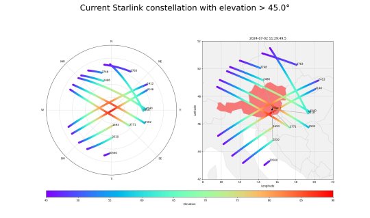
Utilizing communication satellites to survey Earth
Useable data is one of the most valuable tools scientists can have. The more data sources they have, the better they can make statements about their research topic. For a long time, researchers in the field of navigation and satellite geodesy found it regrettable that although mega-constellations with thousands of satellites orbited Earth for communication purposes, they were unable to use their signals for positioning or for observation of Earth.
In the FFG project Estimation, the Institute of Geodesy at Graz University of Technology (TU Graz) has now conducted research on ways of utilizing these signal data and thus tapping into a large reservoir of additional data sources alongside navigation satellites and special research satellites, which will help to observe changes on Earth even more precisely.
Earth observation using satellites is based on the principle that changes in sea level or groundwater levels, for example, influence Earth's gravitational field and therefore the satellite trajectory. Scientists use this to utilize the positions and orbits of satellites as a data source for their research.
"The increasing availability of satellite internet in particular means that we have a huge number of communication signals at our disposal, which significantly exceed those of navigation satellites in terms of number and signal strength," says Philipp Berglez from the Institute of Geodesy.
"If we can now use these signals for our measurements, we not only have better signal availability, but also much better temporal resolution thanks to the large number of satellites. This also allows us to observe short-term changes. This means that in addition to determining the position and changes in Earth's gravitational field that are relevant for climate research, weather phenomena such as heavy rain or changes in sea level can also be tracked in real time."
One of the challenges in realizing the project was that satellite operators, including Starlink, OneWeb and the Amazon project Kuiper, do not disclose any information about the structure of their signals, and these signals are constantly changing. In addition, there are no precise orbit data or distance measurements for the satellites, which represent potential sources of error for calculations.
By analyzing the Starlink signal, the researchers nevertheless found a way to enable the desired applications. They detected sounds within the signal that were constantly audible. They then utilized the Doppler effect and investigated the frequency shift of these constant tones as satellites moved towards and away from the receiver. This allowed the position to be determined with an accuracy of 54 meters.
Although this is not yet satisfactory for geodetic applications, for the investigations that have been carried out so far, only a fixed, commercially available satellite antenna was used to test and verify the basic principle of the measurement method.
More insight into how our world is changing
The aim now is to improve the accuracy to just a few meters. This will be made possible by antennas that can either follow the satellites or receive signals from different directions. In addition, measurements are to be taken at several locations in order to increase accuracy and reduce the influence of errors.
With more measurement data, the researchers can calculate more precise orbit data, which in turn makes determining positions and calculating Earth's gravitational field more accurate. The navigation working group also wants to develop new signal processing methods that filter out more precise measurement data from signals that have so far been rather unusual for geodetic applications.
"By being able to utilize the communication signals for geodesy, we have revealed enormous potential for the even more detailed investigation and measurement of our Earth," says Berglez.
"Now it's all about improving precision. Once we have succeeded in doing this, we will be able to understand even more precisely what changes our world is undergoing. Just to be on the safe side, I would like to make the following clear: we are analyzing communication signals here, but we cannot and do not want to know their content. We really only use them for positioning and observing orbits in order to determine Earth's gravitational field."
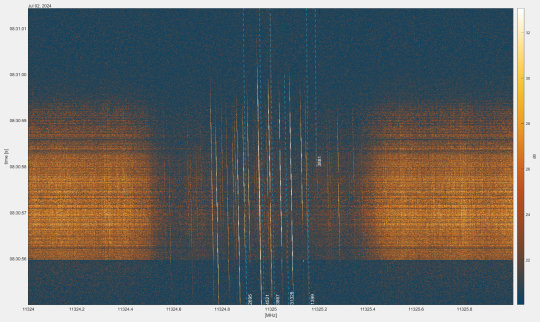
TOP IMAGE: Signal spectrum of the received Startlink satellite signals. Credit: IFG - TU Graz
LOWER IMAGE: The visibility of Starlink satellites over Graz. Credit: IFG - TU Graz
3 notes
·
View notes
Text
Survey Services | AABSyS
Check out AABSyS Survey Services to improve your data insights. Find important facts and come to wise decisions. Find out more now.
#construction survey drafting services#road data capture services#geodetic data survey services#manual survey services
0 notes