#North India Winter
Explore tagged Tumblr posts
Text
हरियाणा में ठंड बढ़ी: वेस्टर्न डिस्टर्बेंस के असर से बारिश और बूंदाबांदी की संभावना
Haryana Weather Update: हरियाणा में सर्दी ने अपना असर दिखाना शुरू कर दिया है। पश्चिमी विक्षोभ (वेस्टर्न डिस्टर्बेंस) के सक्रिय होने के कारण प्रदेश के मौसम में बदलाव देखा जा रहा है। मौसम विभाग ने आगामी 9 दिसंबर 2024 को प्रदेश के कुछ हिस्सों में हल्की बारिश और बूंदाबांदी का पूर्वानुमान जारी किया है। इसके साथ ही, तापमान में गिरावट का सिलसिला भी जारी रहेग��। बारिश और बूंदाबांदी की संभावना मौसम…
#9 December Weather Update#Haryana Pollution Level#Haryana Rain Forecast#Haryana Temperature Today#Haryana Weather Update#Hisar Cold Weather#Kal Ka Mausam#North India Winter#Rain in South India#Weather Alert India#Western Disturbance Impact in Haryana
0 notes
Text


Spiti Valley (2) (3) (4) by Kandukuru Nagarjun
Via Flickr:
(1) Chorten (2) Chicham bridge
#snow#winter#landscape#chorten#stupa#bridges#crevasse#dogs#houses#india#north india#himachal pradesh
6 notes
·
View notes
Text
Everyone reblogging this should just come to India and sit on my terrace with me everyday after breakfast
a sunny day during the winter months will have you feeling like you were reborn
5K notes
·
View notes
Text
Discover the Adventure of Hampta Pass
Hampta Pass is one of the most dramatic and adrenaline-pumping trek experiences and a stretch in Himachal Pradesh at a height of 14,000 feet. On one side lies the lush green Kullu Valley; on the other side, the stark, arid landscape of Lahaul—a contrasting view that changes drastically within minutes while trekking. This is one of the most exciting treks, which takes you to a land with a unique terrain that resembles the Valley of Flowers. It beautifully merges adventure and breathtaking Himalayan beauty together into one.
What Does the 5-Day Trek Look Like?
Hampta Pass is a trek which offers five days of continuous landscapes and activities. From the noisy town of Manali, the trail enters into the dense forests and green meadows. Chika is the first campsite, a beautiful site with a gurgling stream nearby. Further on, you arrive at Balu Ka Ghera, another quiet spot surrounded by majestic snow-capped peaks. The highlight of the trek is undoubtedly the challenging, tiring climb to Hampta Pass itself that involves a thrilling climb over rocks and snowy patches. On the other side, while descending into the Lahaul Valley, you will come across a beautiful campsite at Shea Goru, entirely surrounded by stark mountains with no trees or grass in sight. Your final visit to the mesmerising Chandratal Lake with crystal-blue water amidst stunning high-altitude scenery marks the end of this journey. Each new day rolls out carpeted with many surprises, coupled with unmatched natural beauty that shall remain an unforgettable adventure.
#travel#hampta pass trek#north india#winter treks#treks in india#hampta pass#travelling#tourism#trekking
1 note
·
View note
Text
Writing Reference: Weather
Bombogenesis and bomb cyclone - A bombogenesis is “the process that occurs during a 24-hour period when the atmospheric pressure of an extratropical cyclone drops with enough intensity to produce explosive cyclogenesis.” The central barometric pressure drops quickly, producing hurricane-force winds and heavy snow or rainfall—like 77 inches worth of snow in one day. Nor’easters often undergo bombogenesis as cold winds from the north mix with warmer ocean water from the south, creating a big temperature range. These “weather bombs” or bomb cyclones can become blizzards when the conditions are just right. These bombs happen mostly in the fall and winter, but they aren’t unheard of during other times of the year.
Crepuscular ray - A twilight ray of sunlight shining through breaks in high clouds and illuminating dust particles in the air.
Derecho - A widespread and severe windstorm that moves rapidly along a fairly straight path, and it is associated with bands of rapidly moving thunderstorms. In some instances, the media will refer to derechos as "inland hurricanes".
Frazil - “Ice crystals formed in turbulent water, as in swift streams or rough seas.” However, frazil can also form in lakes and oceans; it is the start of sea ice. Frazil usually forms on very clear nights with very low temperatures.
Gloriole - “A halo, nimbus, or aureole.” When ice crystals are suspended in the atmosphere, light catches them causing a bright halo or even a rainbow around the sun or moon. The gloriole forms 22 degrees away from the center of the object, but this phenomenon can often be confused with coronas that form due to water droplets.
Graupel - A type of precipitation that is formed when really cold water droplets collect, freeze, and fall on snowflakes. This creates what is known as a ball of rime, which is “an opaque coating of tiny, white, granular ice particles.”
Haboob - “A thick dust storm or sandstorm that blows in the deserts of North Africa and Arabia or on the plains of India.” Haboob’s dust-storm cousin also hits the United States—just ask anyone who lives in Phoenix. These dust storms usually occur during or as a result of a thunderstorm.
Hunch weather - This term dates back to the 1700s; drizzle or winds that are strong enough to make you hunch over when you walk.
Monkey's wedding - Sunshine and rain at the same time; also known to be called sun showers. However, in South Africa, a “sun shower” is also known as a monkey’s wedding.
Moonbroch - A large halo around the moon; it is a sign of an approaching storm. A broch is an old term for a Scottish circular stone tower.
Petrichor - The distinct scent of rain in the air. More precisely, it’s the name of an oil that’s released from the earth into the air before rain begins to fall.
Polar vortex - A massive whirlpool of cold air that hovers above Earth’s North and South poles. During the warm months, the vortex shrinks toward the poles and generally stays out of our hair, which is nice. During the winter though, the vortex’s boundary—a narrow band of fast air called the polar front jet stream—expands, dipping toward the equator and dumping frigid weather onto any unsuspecting towns (or commuters) in its path.
Sastruga - (Sastrugi in the plural form) means “ridges of snow formed on a snowfield by the action of the wind.”
Smuir - “A thick atmosphere, a dense enveloping cloud or swirl of smoke, snow, rain, or mist.” Alternatively, a blind smuir is merely a snowdrift.
Snow - The partially frozen water vapor which falls in flakes.
Snow eater - When there’s snow everywhere. But, all of a sudden, a nice warm breeze blows over the snow and melts it all away. This usually happens in the Rockies.
Snow flurries - Light, intermittent snowfall without significant accumulation; tend to come from stratiform clouds.
Snow showers - A short period of light-to-moderate snowfall, also characterized by a sudden beginning and ending. There is some accumulation with snow showers, and they fall from convective or cumuliform clouds.
Snow squall - A heavy snow shower with strong winds.
Sugar weather - In Canada, when they have nice warm days but chilly nights, that’s known as sugar weather. That type of weather is just right for getting the maple syrup running in the maple trees.
Swullocking - Hot, sticky, humid weather during the summer; humid weather.
Thundersnow - When snow is the primary form of precipitation in a thunderstorm (instead of rain).
Virga - The virga phenomenon is when you can see that it is raining, but it evaporates on the way to the ground and ends up changing back to water vapor before you can feel it. When it rains and the rain actually makes it to the ground, there’s a meteorological word for that, too: praecipitatio.
Williwaw - A violent squall that blows in near-polar latitudes, as in the Strait of Magellan, Alaska, and the Aleutian Islands.
Sources: 1 2 ⚜ More: On Weather ⚜ Calm & Stormy ⚜ Writing Resources PDFs
#weather#word list#writing reference#spilled ink#dark academia#writeblr#writing inspiration#creative writing#words#langblr#linguistics#literature#writers on tumblr#writing prompt#poets on tumblr#poetry#writing ideas#writing inspo#light academia#nature#writing resources
70 notes
·
View notes
Text

Digvijay Lande
Ruddy Shelduck
The ruddy shelduck (Tadorna ferruginea), known in India as the Brahminy duck, is a member of the family Anatidae. It is a distinctive waterfowl, 58 to 70 cm (23 to 28 in) in length with a wingspan of 110 to 135 cm (43 to 53 in). It has orange-brown body plumage with a paler head, while the tail and the flight feathers in the wings are black, contrasting with the white wing-coverts. It is a migratory bird, wintering in the Indian subcontinent and breeding in southeastern Europe and central Asia, though there are small resident populations in North Africa. It has a loud honking call.
62 notes
·
View notes
Text
The Pleiades
Astronomy Facts
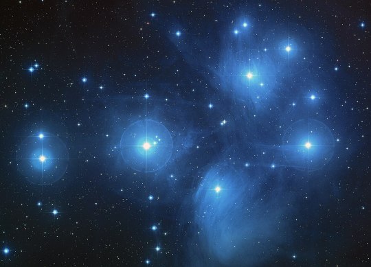
The Pleiades, also known as the Seven Sisters or Messier 45 (M45) is an asterism, or star group of an open star cluster containing young B-type stars that formed in the last 100 million years just above the shoulder of Taurus the bull constellation.
It's on average about 444 light years away from Earth. That means the light in this photo left the star cluster in 1581. It's also the nearest Messier object to Earth. It's the most obvious star cluster visible to the naked eye.
In Ancient Times
They were one of the first stars mentions in literature, appearing in Chinese Annuals in 2350bc. The Nebra sky disc found in Germany has these stars displayed with the Sun and Moon, this disc was made in the 1600BC. Sailors used them for navigation, as the “Plein” in their name literally means “To sail” in Ancient Greek. Farmers used them as a marker for when to sow and harvest crops, since they appear in the autumn, being a winter Asterism. The Zuni tribe of New Mexico called them “seed stars” and when the stars disappeared in the spring they sowed their crops. Other cultures believed they seeded the planet and were the seven mothers of Earth, (hey Hemidal of the Aesir in Norse Mythology had nine mothers).
In ancient times the Pleiades played a role in establishing many calendars.
In ancient India, in the Atharvaveda (the knowledge store house of Antharvanas, the procedures for everyday life, the fourth Veda and part of the Vedic scriptures of Hinduism) the Pleiades have the name Kttika, which meant the cuttings or those that mark the break of the year.
The Stories
The Pleiades are a very visible star cluster and because of that and because it's close to the ecliptic (the line of the sun's passage in the night sky or the zodiac line) and it's seasonal appearance makes it a great source of stories, folklore and myths.
Nearly all of them say they're 7 sisters and usually explain why they see 6 stars.
North Africa
The Tuareg Berbers, a semi nomadic ethnic group from North Africa (mainly the Sahara) call the Pleiades Cat ihed meaning Daughters of Night. Their proverb (translated into English) is: “When the Daughters of Night fall, I wake looking for my goatskin bag to drink. When they rise, I wake looking for cloth/clothes to wear”
This means that when the Pleiades sink below the horizon at spring, Summer is coming, and in the desert will be getting hot and drier, and they rise in the Autumn and that is when the rainy season starts, so start dressing warmer.
Native American
Wyoming- Kiowa tribe
In Wyoming, North America stands Mateo Tipi or Devil’s Tower. Legend is that one day the tribe was going south, and a bear attacked a group of seven girls. They climbed the rock and asked the Great Spirit for help. The Great Spirit made the rock grow taller and the bears kept clawing and scraping it away, so the rock grew taller still. Until the little girls were high in the sky and became stars.
Greek Myth
I'm ending on this one as it ties to a winter cconstellation. Also we often use the Greek names in astronomy.
The Pleiades in Greek mythology are daughters of Pleione and Oceanid and the Titan Atlas.
The sisters names are:
· Maia (mother/ nurse/ great one) who was the mother of Hermes
· Electra who was the mother of Dardanus and Iasion by Zeus
· Taygete mother of Laceaemon by Zeus
· Alcyone (ally) the mother of Hyrieus, Hyperenor, Aethusa, Hyperes, Anthas and Epopeus by Poseidon
· Celaeno mother of Lycus, Nycteus, Eurypylus and Euphemus by Poseidon
· Sterope (Asterope) (star) mother of King Oenomaus by Ares (some stories say she's Oenomaus wife)
· Merope the youngest who married Sisyphus.
Merope is the lost sister as her star is the last to have been mapped by Astronomers and is the faintest star, invisible to the naked eye. In the stories she's lost either because she married a mortal, or because she married Sisyphus who was punished in the underworld for both murdering his guests and repeatedly literally escaping from death . His punishment is to roll a stone up a hill forever. Either way Merope faded away. In other versions the lost sister is Electra, whose son was the King of Troy and she faded when Troy fell.
In one version of their story, the Pleiades were grief stricken at either their father Atlas who was punished after the Titan's war with the Olympians by being forced to hold up the heavens , or the fate of their sisters the Hyades and killed themselves. Zeus changed them into stars.
Another version that ties to the constellation of Orion is that after Atlas was imprisoned Orion began to relentlessly pursue the Pleiades. They were companions of Artemis who asked her father Zeus to protect them. Zeus changed them into doves then stars. Artemis was then angry that she lost her companions so her brother Apollo created a Scorpion that killed Orion. Orion then was changed into a constellation and so was the Scorpion (Scorpio) and Orion continues to pursue the Pleiades in the sky, and he in turn is chased off the sky by Scorpio.
50 notes
·
View notes
Note
Lieutenant! Can you tell us about Cape Horn and why it was so dangerous?
Of course I would,
So let's get to the location:
Cape Horn is located at 55° 59′ south latitude and 67° 17′ west longitude. The headland is located on the rocky island of Isla Hornos (Horn Island, not to be confused with the Horn Islands in Micronesia, also discovered by Schoutens), which belongs to Chile, and is the southernmost point in the Tierra del Fuego archipelago. Like the southernmost 2,000 kilometres of South America, it lies in the cold Antarctic circumpolar current. Unlike South Africa, which is twenty degrees further north with the warm Agulhas Current, Tierra del Fuego is never reached by a warm Atlantic current (Brazil Current). Instead, the cold polar current (Falkland Current) reaches as far as the Río de la Plata in the southern summer and as far as southern Brazil in the winter, meaning that Cape Horn is under the influence of a large-scale subpolar current all year round.
The air temperature at Cape Horn is almost identical to the water temperature all year round - day and night - which is 8 °C in January and 5 °C in July. During the day, it rarely gets warmer than 12-13 °C. There are only occasional frosts in winter and it almost never snows, although it rains over 280 days a year.

With few exceptions, the wind blows from the western half of the compass rose all year round; easterly winds are very rare. However, the wind force in the sea area around the Cape tends to be lower than in the neighbouring south-east Pacific and off the Chilean coast near the Strait of Magellan, for example, where there is always one wind force more and twice as much chance of storms. Nevertheless, the wind blows almost constantly in summer (January) with at least five Beaufort, but only once a month with more than seven Beaufort, and once a week to the west. In July, at least seven Beaufort and one storm per week are recorded every third day, while two storms per week can be expected to the west.
The Cape was rounded for the first time by an expedition of Dutch sailors Willem Cornelisz Schouten and Jakob Le Maire on 29 January 1616, sailing on behalf of the Australian Company, which was founded by Jakob Le Maire's father Isaac Le Maire together with other Hoorn businessmen after an internal dispute with the Dutch East India Company (VOC). As Dutch ships at the time were only allowed to use the Strait of Magellan if they belonged to the VOC, Isaac Le Maire was looking for a passage to the Pacific untouched by the rights of the VOC to trade with the East Indies Spice Islands.
The expedition's mission was to explore a new route to the ‘East Indies’.It was considered fulfilled when a passage opened up between Tierra del Fuego (in the language of the Spanish owner) and the hypothetical huge southern continent of Terra Australis.It was named Fretum le Maire (literally Le Maire Strait) in Latin in honour of the initiator and most important financier Isaac Le Maire, and the ‘peninsula’ to the east belonging to Terra Australis was given the name Staatenlandt in honour of the newly constituted Dutch parliament.The rededication in favour of the son Jakob Le Maire took place after his tragic death at the instigation of his father.The island character of Staatenlandt, which is only sixty kilometres long, could not be recognised, as even at sea you can rarely see further than about forty kilometres. Not being able to see the connection of the state island to the huge Terra Australis only proved that one could not see further than twenty nautical miles - and this was already known.
According to the published records of the ‘shipwrecked passenger’ Jacob le Maires (his expedition ship, the Hoorn, burnt up during cleaning work in Patagonia), he and Captain Schouten were of the opinion that Tierra del Fuego was a rugged, rocky but contiguous island, the supposed southern tip of which was named Capo Hoorn in Latin by Schouten, who was responsible for it, in honour of the second great financier, the council of the city of Hoorn.The Le Maire Strait, the short and easy passage between America and Terra Australis at Staateninsel or Staatenlandt, was the important discovery; Cape Horn was already a clear 180 kilometres into the Pacific. Isaac le Maire had the discovery of this passage, supported by a ‘silent’ Schouten, attributed to his son by court order, with the father as heir.However, the associated and desired exploitation rights of the strait were immediately expropriated and granted to the monopoly of the East India Company.The last lawsuits over this were lost in 1648.
With the realisation that even Staatenlandt was not connected to Terra Australis and that Cape Horn was the decisive landmark, neither the Strait of Magellan nor the Le Maire Strait could be permanently managed with customs duties. Due to the factually and historically incorrect, commercially motivated court judgement that Jacob le Maire found his way into the Pacific via the Le Maire Strait, the discovery of Cape Horn is attributed to him just as incorrectly and abbreviated. Usually, however, all discoveries made on such a voyage are attributed to the captain, as he decides which unknown waters his ship sails into, is responsible for them and also has to assess and interpret what he sees. However, Schouten did not insist on a public acknowledgement of his exploratory achievement, presumably due to an ‘agreement’ between him and Isaac le Maire. In addition, the published documentation of the voyage was undoubtedly written by the representative of the shipping company Jacob le Maire, so that the impression of a discovery by the travelling merchant was already being conveyed to contemporaries
But according to the German author Wolf-Ulrich Cropp, the Englishman Francis Drake was the first European to sail around the Cape 40 years earlier, in 1578, on his circumnavigation of the globe, after he had reached the Pacific through the Strait of Magellan and then travelled south-east for a few days in search of the missing escort ships. However, this discovery was declared a state secret by Queen Elizabeth I.
At the time, it was believed that the Pacific could only be reached from the Atlantic via the Spanish-controlled Strait of Magellan further north, and the British did not want other nations to know about the second route.Drake's first discovery was only claimed after 1618 for political and economic reasons and was quickly disproved by examining the records and voyage reports and by interviewing the surviving travellers.The English naming of the sea area Drake Passage was only given in 1769 by James Cook when he surveyed the coast and is presumably only an expression of general reverence for the greatest English naval hero to date.
In fact, Drake no longer had any escort ships in the Pacific that he could miss; he had already lost them in the Atlantic or in the Strait of Magellan.In the event of a separation, a rendezvous point 2500 kilometres to the north had been agreed with the remaining Elisabeth; a search for missing persons in the south was therefore not very promising. Instead, Drake sought shelter between the islands west of the Strait of Magellan in a supposed ‘50-day storm’ and had no interest in drifting further and further south-east, where he would inevitably be wrecked on the expected Terra Australis in the storm.In any case, he took his time to ‘conquer’ the inhospitable islands of the archipelago one by one.Furthermore, the navigational documents show that he never travelled further south than 55° south, which, in view of his otherwise perfect latitude measurements throughout the voyage, rules out the possibility that he came closer than about 300 km to Cape Horn.Under no circumstances was he south of the Cape, travelling through the Drake Strait and the Le Maire Strait or Falkland Strait to the Atlantic entrance of the Strait of Magellan, in order to make a statement about its passability.The ambitious Drake would have seized even the slightest opportunity to make and verify such a glorious discovery, as he was well aware of the economic, personal, political and military benefits.Similar legends were subsequently spread about the Spanish captains Francisco de Hoces (1526) and Gabriel de Castilla (1603). However, the sources and evidence for both are so sparse and uncertain that the best that can be surmised is that they both sailed past the entrances to the Strait of Magellan for different reasons and then wandered south of it for a short time. In the case of de Hoces, the legend led to the same conclusion as with Drake: the sea area south of Tierra del Fuego, the Drake Strait, is called Mar de Hoces in Spanish.
The rounding of the Cape was one of the most feared passages for ships, as evidenced by the founding of the Cape Horn Community. Commanding captains who conquered Cape Horn on a cargo ship without an auxiliary engine became honorary members of this international community.
Until the completion of the Panama Canal in 1914, sailing around the Cape was the slightly more favourable way to reach the west coast of South America from the Atlantic. The Strait of Magellan and the Beagle Channel, which had already been sailed through centuries earlier by ships of the Dutch East India Company and British exploration ships, also offered difficult weather and current conditions for sailing ships.
At Cape Horn, the passage from the Atlantic to the Pacific against the westerly wind drift was particularly dangerous and difficult. It required ships sailing in this direction to constantly cross in high seas, rain, cold, poor visibility and icebergs. The False Cape Horn caused additional navigational difficulties due to the risk of confusion. However, to this day there are still ships that round the cape, albeit with the help of engines and modern navigation. But that does not mean that it is any less dangerous.
44 notes
·
View notes
Text
Estimating Twisted Wonderland's Circumference ONCE AND FOR ALL
howdy. In this post, I once attempted to figure out the circumference of Twisted wonderland. Instead, I failed, and just went mad collecting screenshots of random spheres that weren't/might be globes modeling the planet.
that's not important. What IS important is the rant about the map that we DO have that followed. y'see, it looks like this.
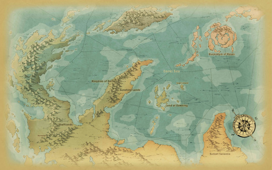
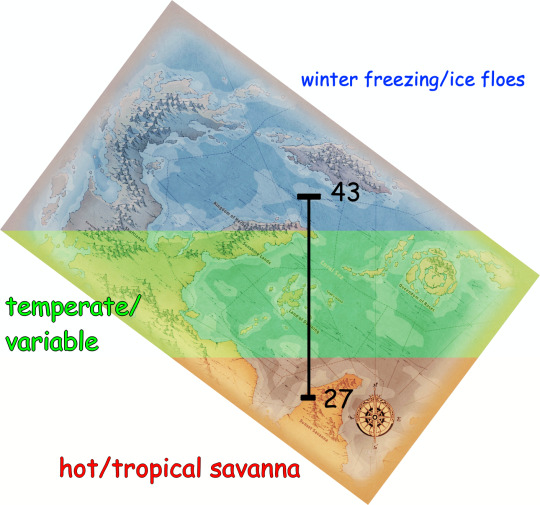
Tilted. Cropped. Incomplete. Utterly infuriating. Anyway, we're gonna be working with my SUPERIOR map projection for this theory post.
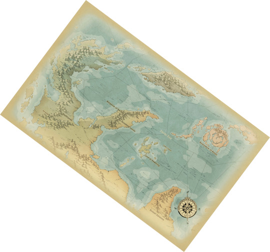
yeah it's literally just tilted so that North points straight up. There's almost no way to really tell what latitude location is or how large it is compared to the rest of the world... EXCEPT...
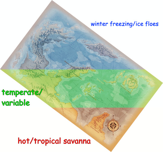
...FOR THE CLIMATES.
it's pretty easy to label the middle section as "temperate," since summers are hot, winters are snowy, and every other season is pretty comfortable.
The northern parts of the Coral Sea can be determined as arctic or near-arctic, because Azul and the tweels don't bother being there during the winter due to the ice covering the water's surface. The furthest south that winter sea ice extends on earth is the coast of Hokkaido, Japan, at 43 degrees north.
Last but not least, as Sunset Savanna is based on the setting of the lion king, that makes it a tropical savanna. The most northern tropical savanna on earth is the Terai–Duar savanna at the base of the Himalayas in India, at 27 degrees north.
Therefore, this whole (VERY inexact) area I marked on this map that holds the temperate zone is around 16 degrees of Twisted Wonderland's latitude, possibly more.
Now, we don't exactly have a giant perfect ruler that we can use for reference. but we DO have the next best thing: Sage's Island!
And 16 degrees of Twisted Wonderland's latitude seems to beeee…
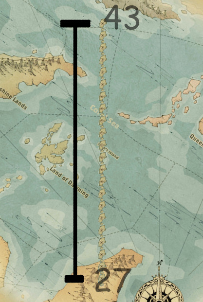
22 Sage's Islands long!
So this lil island is about 0.727 degrees long.
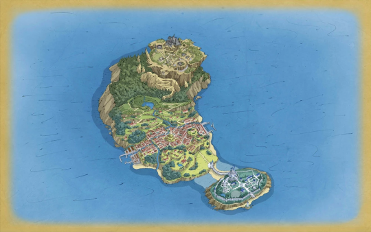
Now, I'm none too confident in my island-length-guessing ability. So i gotta say Sage's Island is like... maybe 3 miles long, north to south.
Soooo... 3 miles is 0.727 degrees in Twisted Wonderland.
That means 1 degree is 4.126 miles.
And that means the full 360 degrees of Twisted Wonderland's circumference is... drumroll please...
...
1,485.36 miles/2390.46 kilometers.
Give or take, I mean. I'm not a scientist. I don't even play Twisted Wonderland.
PLEASE understand that is a TINY amount. Earth's circumference is 40,075.017 km. PLUTO has a circumference of 7,231 km. Twisted wonderland is smaller than Pluto.
We were ROBBED of Yuu being capable of jumping 50 feet in the air due to the weaker gravity.
#i guess you could say...#it's a small world after all#heheheHA#shitpost#twisted wonderland theory#twst#cartography#'yuu's power is beast taming/cooperation/being blunt.' No their power is their 50 FOOT VERTICAL LEAP#can you tell i read too much of John Carter of Mars#this whole theory falls apart if sea ice and tropical regions just extend farther in Twisted Wonderland for some reason#or if the map isnt to scale at ALL#it also falls apart if.. yknow... the world is flat.#which it might be. we dont have confirmation of a round world for TWST.#small planet twisted wonderland#headcanon
242 notes
·
View notes
Text
Kal Ka Mausam 9 December 2024 : उत्तर भारत में ठंड का प्रकोप और दक्षिण भारत में भारी बारिश की चेतावनी
Kal Ka Mausam 9 December 2024 : देशभर में मौसम ने करवट ले ली है। उत्तर भारत में ठंड और कोहरे ने जनजीवन प्रभावित कर दिया है, वहीं दक्षिण भारत में बारिश और चक्रवात का अलर्ट जारी किया गया है। आइए जानते हैं 9 दिसंबर 2024 को देश के प्रमुख हिस्सों में कैसा रहेगा मौसम। उत्तर भारत: ठंड और कोहरे का कहर उत्तर भारत के कई हिस्सों में घना कोहरा छा गया है। पंजाब, हरियाणा, उत्तर प्रदेश और राजस्थान में शीत लहर…
0 notes
Text
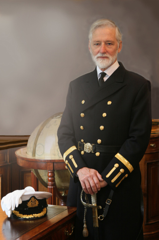
Richard Woodman
Writer who drew on his own experience at sea in a series of novels and historical works about the British merchant navy
“The end was anticlimax. We slipped home unnoticed. Britain turned no hair at our arrival, as just as she has turned no hair at our extinction.” When Richard Woodman published Voyage East in 1988, he knew that the mercantile world depicted within it, which he had joined aged 16, was gone.
The first-person novel – which never reads like fiction – describes the voyage of a cargo liner carrying goods and passengers from Liverpool to Singapore, Hong Kong, Kobe and Shanghai in the mid-1960s. There is a moment, off the coast of Borneo, when the captain sees a vessel with half a dozen grey aluminium boxes on her foredeck: “What the devil are they?” he asks the pilot. “‘They’re containers, Captain,’ the Pilot replied, and no one on the bridge heard the sentence of death pronounced upon us.”
Woodman, who has died aged 80, became the memorialist of the merchant fleets. Between 2008 and 2016 he wrote the history of the British merchant navy in five volumes, followed by A Low Set of Blackguards, a two-volume history (2016-17) of the East India Company.
His outstanding contribution came through his three second world war convoy histories: Arctic Convoys (1994), Malta Convoys (2000) and The Real Cruel Sea (2005). These are works of passion, based on experience and scrupulous research.
The loss of life among merchant seamen was proportionately greater than in any of the armed services and the recognition they received far less. From the beginning of the war a seafarer’s pay was stopped the minute his ship was sunk. “Time spent fighting for his life on a float or lifeboat was an unpaid excursion,” wrote Woodman.
While Winston Churchill acknowledged the crucial importance of the Battle of the Atlantic to national survival, it was not until 2012 that those who had served in the Arctic convoys, and had taken the highest casualties of all, were retrospectively honoured.
Born in north London, Richard was the elder son of Rosalie (nee Cann) and Douglas Woodman, a civil service administrator. Though he was far from the sea, his imagination was captured by the works of Arthur Ransome, Daniel Defoe, RM Ballantyne and Alan Villiers, and his enthusiasm nurtured by Sea Scout membership.
He was the youngest member of the Sea Scout crew that sailed the ex-German yawl Nordwind in the 1960 Tall Ships race and, despite failing all but two of his O-levels, he was accepted as an indentured apprentice with the Alfred Holt (Blue Funnel) line in 1960.
His first long trip to Australia came as a midshipman on the SS Glenarty, returning via the US: “I had been round the world before I would have been allowed inside a British pub.” Life on board ship took place in an uncompromising, all-male environment: the almost compulsory swearing, drinking and sexist banter encouraged the development of “a carapace behind which we hid our private selves”.
Woodman responded eagerly to the hands-on education in seamanship and navigation, developed his writing and sketching through the log-keeping and read his way through the excellent ships’ libraries provided by the Marine Society. He completed his four-year apprenticeship and gained his second mate’s certificate. He was, however, in love and hated saying goodbye to his girlfriend, Christine Hite, an art student, for many months at a time.
He left Blue Funnel in the mid-1960s and went to work for the Ocean Weather Service, where he discovered how vicious the North Atlantic winter weather systems could be – and how pitilessly an ex-second world war corvette would roll. Fortunately it was not long before a temporary position became available with Trinity House, the corporation charged with the maintenance of navigation marks around England, Wales and the Channel Islands.
The position became permanent; he and Christine married in 1969 and settled in Harwich, Essex, near the Trinity House east coast depot, and he served the corporation for most of the rest of his life.
The work at sea was varied, challenging, sometimes dangerous. Precise navigation, seamanship and attention to detail were essential qualities, but Woodman also found time to write. His first novel, The Eye of the Fleet, was published in 1981. This introduced a series of 14 adventures featuring the young Nathaniel Drinkwater, a hero somewhat in the Horatio Hornblower mode but bearing the unmistakable stamp of a writer who was also a sailor.
Despite his professional career being in motorised vessels, Woodman loved traditional gaff-rigged yachts, particularly his own Kestrel and then Andromeda, in which he and Christine explored the east coast rivers and beyond. The action of his nautical novels often turns on neat, seamanlike manoeuvres as well as including varied and closely observed seascapes.
His productivity was astonishing. He often wrote two or three novels a year and soon added non-fiction to his output. When he became captain of Trinity House Vessel Patricia, he achieved this by having two desks, one from which he could conduct official business, the other hidden behind a door, with a page from the work in progress always ready in the typewriter.
Meanwhile, in his job he was extremely focused, conscientious and painstaking. Although some remember him as being of the “old school”, Jill Kernick, the first woman in almost 500 years to work at sea for Trinity House, credits him with helping her break through traditional barriers in the early 80s.
In 1997 Woodman retired to write full time, but was soon elected a Younger Brother of Trinity House, and then an Elder Brother, the first time a former employee was accorded this honour. He was diagnosed with cancer in 2003 but there was no let-up in his work rate. His last completed novel, A River in Borneo (2022), harks back to 60s Indonesia but sets its final scene in a Colchester hospice.
He is survived by Christine and their children, Abigail and Edward, and grandson, Arlo.
🔔 Richard Martin Woodman, master mariner and author, born 10 March 1944; died 2 October 2024
Daily inspiration. Discover more photos at Just for Books…?
26 notes
·
View notes
Text
Moth of the Week
African Death’s-Head Hawkmoth
Acherontia atropos
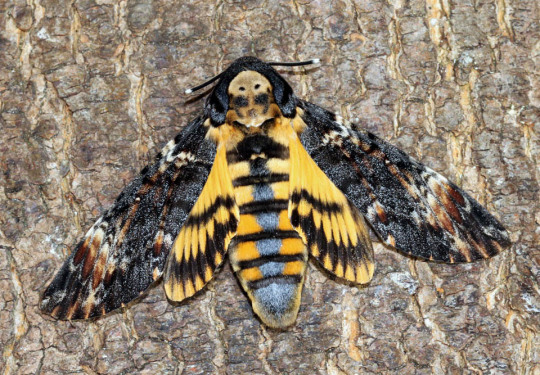
The African death's-head hawkmoth is part of the family Sphingidae and is the most widely recognized of the three species of Death’s-Head Hawkmoth. The species was described in 1758 by Carl Linnaeus. Its common name comes from the skull shape on the back of its thorax. It’s binomial name comes from the river Acheron in Greece, which was believed to lead to the Underworld, and the Greek goddess Atropos respectively.
Description The forewings are black/brown with mottled shades of brown while the hindwings are buff orange with two black/brown stripes that curve with the edge of the hindwing. The head and thorax are the same black/brown color as the forewings interrupted by the brown skull on the back of the thorax. The abdomen is the same buff color as the hindwings with similar stripes of the same color. There is also a single stripe down the center of the abdomen called the “dorsal stripe.”
Average Wingspan: 13 cm (5 in)
Females are large than males with a rounded abdomen tip and larger, thicker antennae
Males have a pointed abdomen tip
Diet and Habitat Larva of this species mainly eat the leaves of potato plants which have alkaloids. The larva accumulate these toxins to become unpalatable to predators. Adults eat the nectar of flowers and stolen honey from the beehives of the Western Honey Bee. They are able to mimic the scent of bees and steal the honey undetected. They use their proboscis, a tube used to drink nectar and honey, to break the honey comb.
Their ranges stretches from the Middle East, as far south as the southern tip of Africa, as far north as southern Great Britain, as far east as India and western Saudi Arabia, and as far west as the Canary Islands and Azores. It is known to move into western Eurasia, but a majority do not survive the winter.
Mating This moth has multiple generations per year. In Africa, the broods are continuous. In the northern range, the larva overwinter in the pupal stage. Eggs are laid singly on the underside of species in mainly Solanaceae but also Physalis, Verbenaceae, Cannabaceae, Oleaceae, Pedaliaceae and others.
Predators This moth can emit a special squeak noise by sucking in air to vibrate a flap in its mouth and throat. The purpose of this squeak is unclear, but the two hypotheses are it is to scare away predators or to mimic the sound of a queen bee makes for the workers to stop moving to easier raid beehives for honey. They are also immune to bee venom and can mimic the scent of bees.
Fun Fact This moth has appeared many times in pop culture as symbols of death and evil:
It appeared in The Hireling Shepherd, Bram Stoker's Dracula, Un Chien Andalou, the promotional marquee posters for The Silence of the Lambs, in the music video to Massive Attack's single, "Butterfly Caught,” and on the American edition's cover of José Saramago's novel Death with Interruptions.
It is mentioned in Susan Hill's Gothic horror novel I'm the King of the Castle and John Keats’s "Ode to Melancholy.”
It is referred to in The Mothman Prophecies.
Finally, the moth is used as a calling card by the serial killer Buffalo Bill. However, in the movie script they are referred to under a different species of death’s-head hawkmoths.
(Source: Wikipedia, Simple English Wikipedia)
#libraryofmoths#animals#bugs#facts#insects#moth#mothoftheweek#lepidoptera#Sphingidae#African death’s-head hawkmoth#Acherontia atropos
168 notes
·
View notes
Note
Why should I strive to accurately reflect your argument when you've refused to do the same with climate change? Ignoring all evidence of humans being capable of affecting their environment and dismissively referring to it as "controlling the weather" which is not close to anyone's argument. The problem isn't me not repeating your argument the problem is you don't like people treating you the same way as you treat others.
Except you guys think that you can literally control the weather if we just tax enough billionaires, regulate enough energy industries, and give up enough freedoms. If the goal is to reduce global carbon emissions, not a single proposed plan to "fight climate change" would do that because they all ignore China and India, which are by far the largest producers of artificial carbon in the world. Even if the west turned off every coal plant and banned carbon production tomorrow, China and India would still be putting out way more carbon than we reduced, to the point where reducing our "carbon footprint" is meaningless. What these plans do accomplish, though, is restricting our freedoms and granting government greater control over the lives of individuals and what's left of the free market. None of the people pushing this climate narrative seem very interested in actually fighting the supposed source of "climate change", so why should I take them seriously?
Humans do affect the environment. I never said otherwise. That's your strawman. My argument is that, if the climate is changing, then human activity is not the main cause. And that's a pretty big if, since your side loves to claim that any weather is evidence of "climate change". One hurricane goes farther north than most hurricanes do? Climate change! Normal amount of hurricanes during hurricane season? Climate change! Indian summer? Climate change! Blizzard in winter? Climate change! Forest fires in a dry, brush covered forest that was started by a human? Climate change! Christ, you people even blame civil wars and riots on climate change. Combine all that with the fact that literally every single climate apocalypse that has ever been predicted, many using the same climate models "scientists" rely on today for their predictions, has never come true, and yeah, I don't believe "the experts" or their manipulated data when they say "No, this time we're totally right you guys. Climate apocalypse is right around the corner!" Climate cultists, because you people do act like a cult, are doing their own supposed cause no favors by acting like hysterical children who keep saying the sky is gonna fall any day now.
I'll make the same deal with you that I've made with other climate weirdos. You live your life like the world is going to end any year now, and I'll live my life like it's not. In 50 years, we can meet up and see which one of us was right and which one of us enjoyed their life more. Maybe on one of the coasts that won't be even remotely close to being underwater.
74 notes
·
View notes
Text


This Brahminy Starling bird photo was taken on a chilly winter morning in the jungles of North India. This one of my my most Aesthetic Bird Photography shot that make these birds look so curious, always looking around there surrounding, taking in the beauty of nature.
#bird photography#birdwatching#birds#wild birds#bird conservation#avian#wildlife#jim corbett#beautiful#breath of the wild#nature photography#wild animals#animals#jungle
17 notes
·
View notes
Note
Hi there, your Europe without trade, a worldbuilding exercise was a fascinating and educational read, kudos for all the insights!
One section has left me with dual questions however, namely:
The other rule is that the Gulf Stream still exists, so you can have that unusual European climate which is a fluke. (This also ticked off people? But seriously, to get the gradient of Europe that far north, you need to Gulf of Mexico otherwise the latitude range would look more like the US than Europe, more south, and larger, much larger. And most people don't make a continent that large. Why people get ticked off at true facts is a whole thing.)
I am rather curious about how these factors interplay with one another, IE, how the Gulf of Mexico creates an unusual climate in Europe, what about the climate is unusual and most integrally, what would the climate look like without it?
Sorry if this is a Wikipedia question, weather science is not my forte and I've love to see your take specifically on it, but not pressure.
I learned this in geography class and covered this in my worldbuilding posts, so short cutted it.
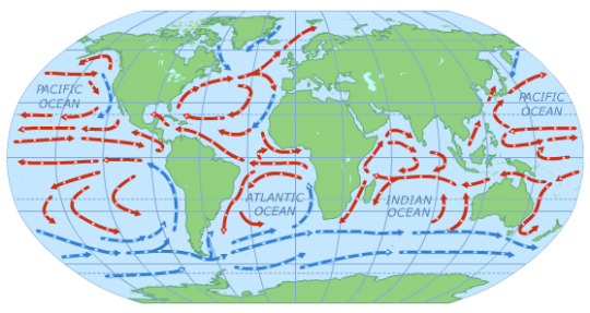
See that red arrow going to Europe from Florida-ish. That's the gulf of Mexico Stream. Hot, wet air travels from Mexico to Europe, giving you climates like the Mediterranean, the rain that Brits complain about, but also things like the South of France, Spainish warm agriculture weather.
If you want to build it super racist and cut off all PoC influence, which some people were cursing me about mentioning the Gulf of Mexico and how dare I at the time I made the original post (which was years back)
Then as my Geography professor succinctly put it, you get Siberia. Siberia, has high continentality, is extremely cold in the winter and extremely hot in the summer. You'd be able to grow NOTHING. No Europe for you. Most of the Siberian people or this reason, without the world food supply were Pastoral Nomadic people who lived in chiefdoms and tribes and survived mostly on grasslands.
The majority of maps, including Tolkien's does not include a Gulf of Mexico structure, which means high continentality and miserable weather. You're looking at only Evenk-type of people in Europe year round with probably diminishing trees, and BTW, shamanism is most likely. (or Totemism, if you follow the whole worldbuilding series I did)
If you do want an Agricultural state without The Gulf, you're more looking at China or the United States in terms of latitude, but you'd have to study China closely. This means larger latitude range with a gradual shift towards Mediterranean. But also more extreme weather, such as more deserts, more swamps, etc. And absolutely, you'd need cooperation.
There's environmental politics about China too,but you'll have to research that on your own.
This, BTW, is why I say as the first thing you probably should do is draw a map, the entire world, map the currents, and then you can figure it out. But notice Europe is really far North and the South of Spain, which is typically Warm is about equal to Newfoundland in Canada which is really cold.
And that's what you're going to get if you melt those ice caps. The summer is going to get worse. The winter is going to get even more miserable. You'll get less warm hot rain for England, etc, but crop failure rate is going to skyrocket. Unfortunately, you need those polar ice caps back ASAP because if it desalinates too much, the Earth will do everything to try to rebalance itself. And do you want that?
Read the geography worldbuilding post I put up. I got up through government loosely.
To get monsoons, you do need high continentality, which is why India, China, etc gets monsoon weather. So if you want that weather feature, understand you need more land mass, but there is the trade off of some place being like Siberia.
BTW, it's climate, not weather. Only saying it because my geography prof would be on my case if I didn't differentiate. You're looking for climate differences which are dictated by latitude, physical features and currents. Another way to screw over Europe is to Destroy the land bridge on the tip of Mexico, thus changing all of the currents and flood it.
#worldbuilding#worldbuilding tips#europe as a continent is weird and usually doesn't belong in worldbuilding#continentality#geography lesson#did you draw your world map yet?#world currents
49 notes
·
View notes
Text
i've said this several times already, but if you want to understand why the news can't even air the phrase "settler-colonialism," which has been accepted as a term in political theory for decades, it's because the imperial core is obviously predicated on it.
if you're wondering why the united nations has no means to effective global governance, it's because the organization was specifically and explicitly convened to replace the league of nations in response to the advent of the nuclear bomb, and to prevent another world war.
the five permanent members of the security council are, not coincidentally, the same countries that have (arbitrarily) 200 or more warheads (which abitrarily excludes pakistan, india, israel, and north korea, for having fewer than 200 of them).
this is widely but very quietly acknowledged as a "nuclear veto," because if a security council member objected to UN governance, they could simply employ the threat of mutually assured destruction.
which, if you want to get down to nuts and bolts, logistically does require some hundred warheads, in order to be a credible threat, although the number 200 is arbitrary. as i've said before, the threat of nuclear winter, as outlined in the original study, is not radiation itself, it's crop loss from occlusion of the sun by soot and smoke. the threat is credible specifically because of its scale. (a similar threat could be made with conventional munitions of approximately equal yield, although manufacturing them would be prohibitively difficult.)
and if you really want to dig into the nuclear aspect of settler-colonialism, you have to recognize the structural use of mining, refining, waste management, and exposure payout: the bomb is simply not the most useful weapon in the field of nuclear policy. the gamble is that nuclear bureaucracy will outlive anyone who wants to object to it, and so far this has been a very profitable bet.
if we could, like, advance the discussion in the public sphere to the basic acknowledgment of this point... it might fucking help! on a personal level i'm tired of being practically the only person to say it
22 notes
·
View notes