#Mingo County
Explore tagged Tumblr posts
Text
I love old train tunnels like these.
There's one where my spouse grew up that was repurposed as a car tunnel. It's only one lane wide, and it's about a mile long so you can't see if someone is coming from the other end pretty much until you meet them. If you do, one of you gets the pleasure of backing out a significant distance. It's also the only fast route in the area; getting around the mountain otherwise is an hour or more using alternate roads. So, you use the tunnel. It's nerve-wracking, but usually your odds are pretty good of not meeting someone.
The fact that it could be obstructed, though...that led to some stuff. Teenagers on one side that didn't want to go to school that day would occasionally pile old tires in the tunnel and set them on fire. Again, because of the length, this often couldn't be spotted immediately. My wife tells the story of her bus driver getting fed up on encountering a tire bonfire one time. The driver told the kids to make sure their windows were up, and drove through the pile at speed. Everyone made it to school on time that day. Can't imagine a driver doing that these days.
Here's some info on it. It's got a wild history all its own.

Excuse me?
179 notes
·
View notes
Text

Mingo Falls, Cherokee Reservation, Swain County, North Carolina. 🇺🇸
📸 by Michael P Sweeny
#Mingo Falls#Swain County#Cherokee Reservation#North Carolina#USA#Waterfalls#Amazing#Beautiful#Nature#Travel#Photography#Adventure#Michael P Sweeny
14 notes
·
View notes
Text
Monmouth County Black History Bus Tour On June 13
On Tuesday, June 13, a Black History Bus Tour sponsored by Brookdale Community College Lifelong Learning Program, will make several stops at historic sites in Monmouth County.
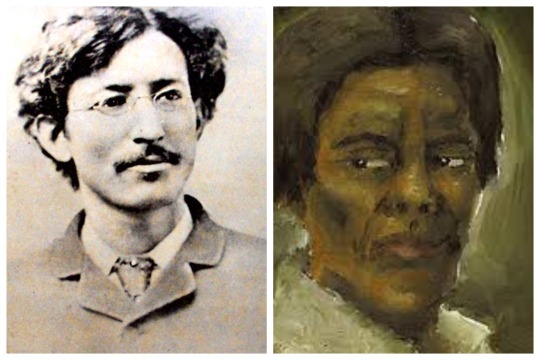
The Get on the Bus tour Part 1 guided by Historian Rick Geffken and Gilda Rogers, will make stops at Wampum Park, the site where Samuel “Mingo” Jack Johnson was lynched in Eatontown;…
View On WordPress
2 notes
·
View notes
Text
It's TFP (Trade For Print/Time For Print), a model call by Joshie's Photography. 📢📸
Joshie's Photography is looking for 2 to 3 people for 2 to 3 free photoshoots (1 each). You can click the link to read the model call below for more details. Once Joshie's Photography has found 2 to 3 people, the offer will no longer be available, so be sure to grab the opportunity soon!
2-3 Model Call by Joshie's Photography: https://www.joshiesphotography.com/model-call-for-2-3-people/
Please share this post and spread the word; help Joshie's Photography to reach out to more people, which would be greatly appreciated!
Thank you, Joshie's Photography.
INFO -
Web: JoshiesPhotography.com Contact: JoshiesPhotography.com/contact/
SOCIAL MEDIA -
Facebook: https://facebook.com/JoshiesPhotography/ Instagram: https://instagram.com/JoshiesPhotography/ More social media: JoshiesPhotography.com/social-media/
#Photography#Photographer#Trade For Print#Time For Print#Pike County Ky#Mingo County Wv#Photoshoot#TFP#Photography TFP#Photography Model Call#Model Call#Photography Model#Pictures#Photos#BelfryKy#WilliamsonWv#Free Photoshoot
1 note
·
View note
Photo


Mingo Junction, Ohio (2) by Sean Marshall
Via Flickr:
Filming location of "The Deer Hunter" and several other films set in coal and steel country.
1 note
·
View note
Text
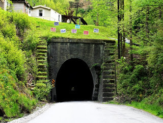
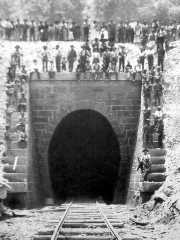
Dingess Tunnel
Hidden deep within the coal filled Appalachian Mountains of Southern West Virginia rests a forgotten land that is older than time itself. Its valleys are deep, its waters polluted and its terrain is as rough as the rugged men and women who have occupied these centuries old plats for thousands of years.
The region is known as “Bloody Mingo” and for decades the area has been regarded as one of the most murderous areas in all of American history.
The haunted mountains of this territory have been the stage of blood baths too numerous to number, including those of the famed Hatfield’s and McCoy’s, Matewan Massacre and the Battle of Blair Mountain. Even the county’s sheriff was murdered this past spring, while eating lunch in his vehicle.
Tucked away in a dark corner of this remote area is an even greater anomaly – a town, whose primary entrance is a deserted one lane train tunnel nearly 4/5 of a mile long.
The story of this town’s unique entrance dates back nearly a century and a half ago, back to an era when coal mining in West Virginia was first becoming profitable.
For generations, the people of what is now Mingo County, West Virginia, had lived quiet and peaceable lives, enjoying the fruits of the land, living secluded within the tall and unforgiving mountains surrounding them.
All of this changed, however, with the industrial revolution, as the demand for coal soared to record highs.
Soon outside capital began flowing into “Bloody Mingo” and within a decade railroads had linked the previously isolated communities of southern West Virginia to the outside world.
The most notorious of these new railways was Norfolk & Western’s line between Lenore and Wayne County – a railroad that split through the hazardous and lawless region known as “Twelve Pole Creek.”
At the heart of Twelve Pole Creek, railroad workers forged a 3,300 foot long railroad tunnel just south of the community of Dingess.
As new mines began to open, destitute families poured into Mingo County in search of labor in the coal mines. Among the population of workers were large numbers of both African-Americans and Chinese emigrants.
Despising outsiders, and particularly the thought of dark skinned people moving into what had long been viewed as a region exclusively all their own, residents of Dingess, West Virginia, are said to have hid along the hillsides just outside of the tunnel’s entrance, shooting any dark skinned travelers riding aboard the train.
Though no official numbers were ever kept, it has been estimated that hundreds of black and Chinese workers were killed at the entrance and exits of this tunnel.
Norfolk & Western soon afterward abandonment the Twelve Pole line. Within months two forces of workmen began removing the tracks, ties, and accessory facilities.
#Dingess Tunnel#haunted tunnels#ghost and hauntings#paranormal#ghost and spirits#haunted locations#haunted salem#myhauntedsalem#paranormal phenomena
55 notes
·
View notes
Photo

George Washington
George Washington (1732-1799) was an American military officer and statesman who led the Continental Army to victory during the American Revolutionary War (1775-1783) and served as the first President of the United States (1789-1797). Often regarded as the ‘Father of His Country’, Washington remains one of the most revered and iconic figures in U.S. history.
Early Life
George Washington was born at 10 am on 22 February 1732 at Pope’s Creek plantation in Westmoreland County, Virginia. He was the first of six children born to Augustine Washington, a wealthy Virginian landowner, and his second wife Mary Ball Washington; George also had four older half-siblings from his father’s first marriage. Little is known about George’s childhood. His early years were mostly spent on the family property of Ferry Farm on the Rappahannock River, and he likely attended school in Fredericksburg, Virginia, where he excelled in the subjects of geometry, trigonometry, and mapmaking. When his father suddenly died in 1743, 11-year-old George inherited Ferry Farm as well as ten enslaved people. Too young to fend for himself, he went to live with his eldest half-brother, Lawrence Washington (b.1718), at Mount Vernon. George idolized Lawrence, who he came to regard as both a father figure and a best friend.
George’s aptitude for mathematics led him to consider a career as a land surveyor, a respectable path to wealth and social advancement. In 1748, at the age of 16, he embarked on his first expedition into the Shenandoah Valley to survey the property of his influential neighbor, Thomas Fairfax. The next year, he earned his surveyor’s license and, through Fairfax’s patronage, was appointed surveyor for Culpeper County. Over the next three years, Washington completed 200 surveying expeditions and measured a total of 60,000 acres along Virginia’s western frontier. But just as George's career was taking off, Lawrence came down with tuberculosis. In November 1751, he went to the Caribbean island of Barbados in the hopes that the tropical air would improve his condition. George accompanied him, and contracted a painful case of smallpox during his brief stay on the island. George soon recovered but Lawrence was not so lucky, as he died shortly after returning to Virginia in 1752. After his brother's death, George started leasing Mount Vernon from Lawrence’s widow and became the legal owner of the property after her own death in 1761.
In 1753, George Washington reached the age of maturity, and was eager to find a way to make a name for himself. He would soon have an opportunity. The French had begun to construct forts on the forks of the Ohio River, fertile territory that had been claimed by Virginia. In November, Washington was sent as an envoy to demand that the French vacate the Ohio Country at once. On his journey into the west, he was joined by Christopher Gist, an experienced frontiersman and guide, and Tanacharison, a Mingo chieftain called the ‘Half-King’ by Virginians. It was Tanacharison who gave Washington the Seneca name of ‘Conotocaurius’ or ‘Devourer of Villages’, in reference to Washington’s great-grandfather, who had helped expel Native Americans from their lands in Virginia. The small party reached the French Fort LeBoeuf during a snowstorm; although they were received cordially by the fort’s commander, Washington’s demands were firmly rebuffed. Washington then embarked on his trek back to Virginia which included several perilous episodes. While crossing the icy Alleghany River in a raft, Washington fell overboard, and likely would have drowned had Gist not pulled him from the water.
George Washington as a Land Surveyor
Henry Hintermeister (Public Domain)
Continue reading...
33 notes
·
View notes
Note
Plsplspls tell me the counties you’ve picked out for D12. From a geography nerd 💕
well grace i am so delighted that you have asked! fair warning- i’m quite biased on this as someone from the area!
so as we know appalachian is pretty expansive and covers quite a few states:

and comparing it to the panem map (which i think is from movies so not technically official. but whatever.)

i like to believe that d12 resides in the heart of appalachia. aka in kentucky or west virginia (or potentially virginia or tennessee).
in this area (where the circle is):

so essentially around the eastern kentucky/west virginia boarder.
i’ve narrowed it down (for my personal hcs) to three counties (+some fun facts!)
mingo county, west virginia
one of the poorest parts of west virginia
has a history of coal mining (including history with the WV coal wars)
the county was named after native americans
pike county, kentucky
one of kentucky’s largest coal-producing counties
largest country by land area and one of the most populous in the state
pike counties cut through project was the second largest in the world, only preceded by the panama canal.
buchanan county, virginia
has one of the largest mines in the state
is known for wrestling (peeta 👀)
the first one is my main pick for the location but i also like the second! the third is fine but i mainly like it for the wrestling connection!
#appalachian nonsense#asks#the hunger games#district 12#omg thank you so much for asking this!!!#and giving me a chance to yap abt appalachia!!!#anyway hope this made sense!!
18 notes
·
View notes
Text

Beautiful February first at Henry Bridge located in Mingo Creek County Park, Washington County, PA
27 notes
·
View notes
Photo
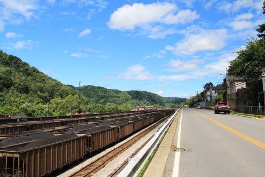
U.S. Highway 52 in Williamson, Mingo County, West Virgina by John Mackinnon
19 notes
·
View notes
Text

Ambassador Gayleatha Beatrice Brown (June 20, 1947 – April 19, 2013) was a foreign service officer and ambassador. She has served in several diplomatic posts during her career with the US Department of State including US ambassador to Benin.
She was educated at the Red Jacket Elementary School, Matewan Elementary, and High Schools in Mingo County, West Virginia. She was senior class president and graduated from Edison High School in Edison, New Jersey. She has BA and MA honor degrees from Howard University. She conducted post-graduate work in international relations at the School of Advanced International Studies at Johns Hopkins University.
Before joining the Department of State, she was a Special Assistant to the Agency for International Development, an Assistant Administrator for Africa, and a legislative assistant in the House of Representatives.
Ambassador to Benin
Counselor for Political Affairs at the US Embassy in Pretoria,
US Consul General at the American Consulate General, and concurrently as the US Deputy Permanent Observer to the Council of Europe in Strasbourg,
Chief of the Economic and Commercial Sections at the US Embassies in Harare and Dar es Salaam,
Desk Officer for Canada, Senegal, Guinea, and Mauritania at the State Department in Washington
Economic Officer/Regional US Agency for International Development Representative and Finance, and Development Officer at the US Embassies in Paris and Abidjan.
Representative of the State Department Organization for Economic Cooperation and Development Export Credit Arrangement negotiations. #africanhistory365 #africanexcellence #alphakappaalpha
3 notes
·
View notes
Note
Me me I want to hear about mining towns what did you learn?
so my research is solely based on West Virginia, specifically McDowell, Logan, and Mingo counties, meaning that other coal towns in neighboring states was probably exactly the same if not just a teensy bit different.
this is also from 1 book so theres still more to learn
anyway info dump below
Essentially before 1870 many people in this area of Appalachia lived in isolated areas. Typically plots of land that had been passed down from generation to generation. We know that Thomas Jefferson was aware of coal in Appalachia so it only makes sense it was a matter of time before companies moved in.
As the companies moved in it ended up trying to take people's land. Twice the supreme court ruled in the farmers favor but the coal companies continued to higher federal local judges basically draining the natives of money and allowing them to commandeer the land
It's important to keep in mind that at the time of the Civil War there was literally 185 mines in the state and those that worked there only did it during a bad harvest
(posting this bc i don't wanna write it all out; these are my notes


again sorry for the screenshots but its so much easier to do this than write it out again. The education part REALLY surprised me
7 notes
·
View notes
Text

This weathered photograph is of Vicey Hatfield Mahon (1861-1948). She was born in rural Logan County, WV.
Her parents were Valentine “Wall” Hatfield (1834–1890) and Jane Maynard Hatfield (1835-1903). Valentine was the brother of Captain Anderson “Devil Anse” Hatfield and siblings.
She married Pliant Mahon in 1877.
Vicey passed at age 87 in Mingo County. She was entombed at the Hatfield-Mahon Family Cemetery at Devon, Mingo County, WV.
5 notes
·
View notes
Text
Georgia Land Lots - A key to researching deeds
I first encountered the term land lot in the Early County, Georgia Tax Digest. As I transcribed the tax information on Mingo Bryant I noted the land lot number and did not give it any thought. Little did I know that this was the key component for Georgia property records. Land lots are unique to Georgia.
Georgia Land Lots
After the American Revolution, the new state of Georgia experienced an influx of people seeking their fortunes. Fueled by the invention of the cotton gin, cotton became the major cash crop.[1] The state of Georgia coveted the Cherokee and Muscogee (Creek) territories for expansion of the plantation system. Increasing the population of Georgia would ultimately increase the state’s political power in Congress.[2]
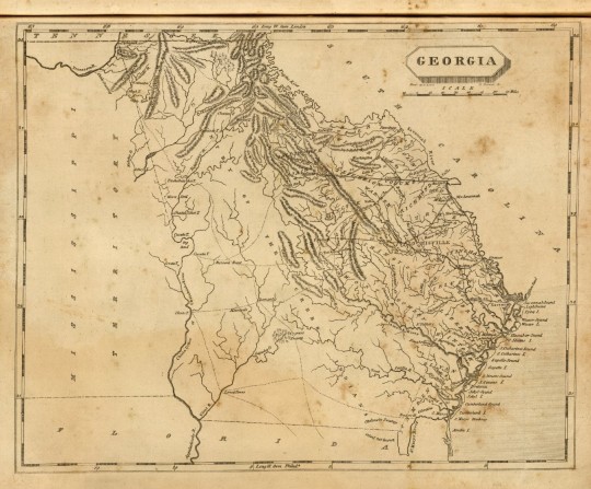
Georgia. Drawn by S. Lewis. D. Fairman sc. (Boston: Published by Thomas & Andrews. 1812). Shows Cherokee and Muscogee territory. [3]
Over a period of time Georgia obtained ancestral Cherokee and Muscogee lands. In 1803 the state of Georgia devised a Land Lottery system to redistribute the land to white settlers. As Georgia gained aboriginal domains, new counties were created by the Georgia Assembly. Land within the county was surveyed and divided into districts. Each district was subdivided into numbered land lots.[4]
Georgia held eight land lotteries between 1805 and 1833. The lands west of the Oconee River and south of the Altamaha River were distributed in lotteries prior to 1833.[5] Each lottery had different size land lots, eligibility and fees.
Early County was created in 1818 from Muscogee (Creek) lands. It was part of the third land lottery which took place in 1820.[6] The original county was divided into districts 1 to 28 (except 24 and 25). Each land lot was 250 acres and the grant fee was $18.00 per land lot.[7] Click on the link 1820 Land Lottery for additional information.
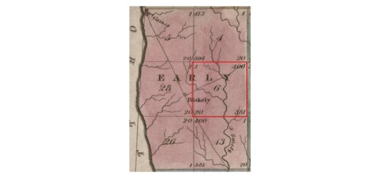
1830 map of Early County, Georgia showing land districts. [8]
Early County, Georgia, District 6
Look at this MAP to view the 1820 District Plat survey of Early County, District 6. Click on the double headed arrow to expand the map. This will enable you to zoom in and see the actual land lot numbers.
Several of my ancestors are recorded living in District 6, Early County Georgia in the 1870 U. S. Census. So far my only ancestors associated with a land lot number are my 2nd great-grandparents, Mingo and Jane Bryant. In the 1879-1881 and 1883-1884 Early County tax digests Mingo is recorded in District 6 with 250 acres real estate, [land lot] no. 223. [9]
Beginning in 1885 Jane Bryant appears in the Early County, Georgia Property Tax Digest as follows:

Now I have a land district and land lot number for Jane Bryant. My next step will be to search for a deed to the property.
The state of Georgia still uses districts and land lots in legal descriptions of land. Georgia requirements for property surveys specify, “The land lot, district, section, militia district number (in Headright Grant areas), city (if known to be within the city limits) and county shall be called out in said description.” [13] A legal description of land in a Georgia deed consists of the land lot, district, lot number and a recorded plat map. A more detailed legal land description has details of the metes and bounds in lieu of the recorded plat map. [14]
Sources
Wikipedia contributors, "Eli Whitney," Wikipedia, The Free Encyclopedia, (https://en.wikipedia.org/w/index.php?title=Eli_Whitney&oldid=1158507059 : accessed July 31, 2023).
Wikipedia contributors, "Georgia Land Lotteries," Wikipedia, The Free Encyclopedia (https://en.wikipedia.org/w/index.php?title=Georgia_Land_Lotteries&oldid=1132885851 : accessed 31 July 2023).
“Georgia,” digital image, David Rumsey Historical Map Collection (https://www.davidrumsey.com/luna/servlet/detail/RUMSEY~8~1~31711~1150506:Georgia : accessed 31 July 2023), citing A New and Elegant General Atlas. Comprising All The New Discoveries, To The Present Time. Containing Sixty Three Maps, Drawn by Arrowsmith and Lewis (Boston: Thomas & Andrews, 1812), map 45.
District Plats of Survey, Survey Records, Surveyor General, RG 3-3-24, imaged as "District plats of survey." 1805/1833. Georgia Archives (http://cdm.georgiaarchives.org:2011/cdm/landingpage/collection/dmf. : accessed 29 July 2023).
“Schley County, GAGenWeb Project Page -- Land.” the GAGenWeb Project ( https://sites.rootsweb.com/~gaschley/land.htm : accessed 1 August 2023).
Lucian Lamar Knight, A Standard History of Georgia and Georgians, Volume I (Chicago: New York: The Lewis Publishing Company, 1917), p. 488, digital images, Google Books (https://www.google.com/books : accessed 29 July 2023).
“Third or 1820 Georgia Land Lottery”, Georgia Gen Web, Crawford County Georgia (http://www.usgennet.org/usa/ga/county/crawford1/Land/thirdlottery1820.htm : accessed 30 July 2023).
Carlton Wellborn, Orange Green and W.Hoogland, Map of the state of Georgia, drawn from actual surveys and the most authentic information. (New York: W. Hoogland, 1830); digital image, Library of Congress (http://hdl.loc.gov/loc.gmd/g3920.tr000287 : accessed 3 August 2023); clip of Early County, Georgia.
Early County, Georgia, "Georgia, U.S., Property Tax Digests, 1793-1892," all years read for entries relating to Mingo Bryant; consulted as "Georgia, U.S., Property Tax Digests, 1793-1892"; digital images, Ancestry (https://www.ancestry.com : accessed 19 Sep 2021) > Early > 1878-1882 > images 120, 247, 391, 537 and 688 of 702.
Early County, Georgia, Tax Rolls 1883-1887, unpaginated entries arranged chronologically, all years read for entries relating to Jane Bryant; consulted as "Georgia, U.S., Property Tax Digests, 1793-1892"; digital images, Ancestry (https://www.ancestry.com/ : accessed 19 Sep 2021); Images 427, 577 and 733.
Ibid
Early County, Georgia, 1890 Tax Book, Damascus Militia District 854, entry for Jane Bryant; digitized in "Georgia, Property Tax Digests, 1793-1892", database, Ancestry (www.ancestry.com : accessed 13 Apr 2021) Early > 1890 > Image 157; citing Georgia Tax Digests [1890], Georgia Archives, Morrow, Georgia.
Rules and Regulations of the State of Georgia, electronic edition, Georgia Secretary of State (https://rules.sos.ga.gov/gac/180-7 : accessed 1 August 2023), Technical Standards For Property Surveys, “Rule 180-7-.02 Land Titles and Location.”
John Bennett, “Georgia Real Estate Legal Descriptions,” post, Linkedin (https://www.linkedin.com/pulse/georgia-real-estate-legal-descriptions-john-bennett# : published 8 May 2023).
2 notes
·
View notes
Photo


Mingo Junction, Ohio (2) by csxt8247
Via Flickr:
The old Wheeling Pitt Steel works in the early morning hours.
0 notes
Text
The reason mainstream society wants you to associate “rednecks” with hicks, white trash, rural backwards-ness, and general stupidity is because of Blair Mountain. The coal miners were wearing red neckerchiefs, and they knew exactly what they needed and how to get it.
And the government’s response was as violent as it would be against the Black Panthers. Possibly more-so, because there were less bystanders to witness what was being done to the mining community of Blair Mountain. The Black Panthers had poor inner city whites around them, the city itself (they bombed a block, but they didn’t destroy the entire neighborhood or anywhere approaching the whole city). The rednecks had themselves and their families. No potential collateral damage to hold the cops back.
It’s really weird, honestly, that we don’t learn about it. We learn about the Pinkertons and the automobile unions, or at least my school taught us about that. And I live in fucking Central Kentucky, Blair Mountain is wayyyy closer than Michigan and the Ford plants.
I was unaware though that it ended September 2 and was the reason for choosing September for American Labor Day. I’ve definitely seen and maybe reblogged a post before about how our government only did that to divide us from International Worker’s Day on May 1, but it’s pretty clear we just had our own event to memorialize and that the only thing the government is doing to divide us from International Worker’s Day is not recognizing it also.
it is absolutely BONKERS to me, the number of people in the united states i have talked to who have never even heard of the battle of blair mountain. how the largest labor uprising in our history manages to skirt by so many leftists unknown is just downright astonishing. the largest labor uprising, and the largest armed uprising, period, since the civil war.
did yall even hear me?
THE LARGEST ARMED UPRISING!! besides the civil!!! fucking!! war!!! was fought in 1921 in the name of LABOR RIGHTS AND UNIONS by TEN THOUSAND RIGHTEOUSLY PISSED, STRIKING COAL MINERS
these absolute fucking LEGENDS marching out the hollers of west virginia, wearing their red bandanas and wielding their papaw's shotguns pointed at the lawmen. waging war against the fucking UNITED. STATES. MILITARY!!! for their right to work safely and be paid fairly!!!
and people just like. don't know about that? put some fucking respect on west virginia!!! and fellow appalachians, yall best just own it when ignorant people call you a fucking redneck cause our ancestors did that shit and they did it for us
#battle of blair mountain#coal wars#appalachia#appalachian history#west virginia#us history#us politics#worker’s rights#rednecks
18K notes
·
View notes