#jefferson county
Explore tagged Tumblr posts
Visit Tumblr Blog
Explore Tumblr blogs with no restrictions, modern design and the best experience.
Last Seen Tumblr Blogs


Fun Fact
The KCSC sent more than 20K requests to delete posts related to prostitution and porn to Tumblr from January to June 2017.
Text
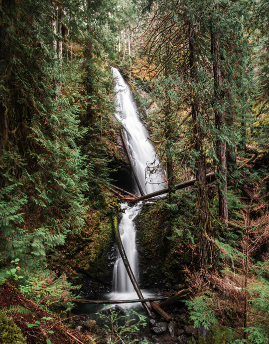
Murhut Falls | Jefferson County, WA
#artists on tumblr#original photographers#original photography#pnw#washington#nikon#nature#pacific northwest#hiking#murhut falls#waterfall#landscape#moody landscape#trees#forest#moss#jefferson county#olympic peninsula
357 notes
·
View notes
Text


The Sculptured House, Genesee, Jefferson County, Colorado, USA,
Designed by architect Charles Deaton in 1963
#design#architecture#art#architects#interiors#iconic architecture#minimalism#nature#sculpture#sleepers#colorado#genesee#jefferson county#elliptical#charles deaton#1963#forms#retreat
33 notes
·
View notes
Text

19 notes
·
View notes
Text


Peter Skene Ogden State Scenic Viewpoint, OR (No. 6)
The Crooked River is a tributary, 125 miles (201 km) long, of the Deschutes River in the U.S. state of Oregon. The river begins at the confluence of the South Fork Crooked River and Beaver Creek in southeastern Crook County. Of the two tributaries, the South Fork Crooked River is the larger and is sometimes considered part of the Crooked River proper. A variant name of the South Fork Crooked River is simply "Crooked River". The Deschutes River flows north into the Columbia River.
The South Fork Crooked River originates in an area called Misery Flat, along the Deschutes County, Lake County and Harney County boundaries, north of Glass Buttes. The South Fork's tributaries drain Hampton Buttes to the west and Mackey Butte to the east. The South Fork Crooked River flows north for 76 miles (122 km), collecting tributaries including Buck Creek and Twelvemile Creek before joining Beaver Creek to form the Crooked River proper near Paulina in Crook County.
Source: Wikipedia
#Peter Skene Ogden State Scenic Viewpoint#Deschutes County#Jefferson County#Oregon#USA#summer 2023#Pacific Northwest#travel#original photography#vacation#tourist attraction#landscape#landmark#countryside#Terrebonne#Crooked River#Crooked River Railroad Bridge#architecture#engineering#Crooked River Railroad Bridge by Ralph Modjeski#flora#tree#nature#Crooked River Gorge#Crooked River High Bridge#Conde McCullough
8 notes
·
View notes
Text

Source
Six more weeks of winter!
5 notes
·
View notes
Text
ok the chances of me finding anything on this webbed site is slim to none but people from my area saw my posts before so??? Worth a shot:
We need somewhere to at least keep our animals - preferably us and the animals - for a SHORT period bc we are looking at long term homes with some friends this spring. We are currently in Jefferson County, WA. My partner can work anywhere but I need to stay within 30ish min of here for my job.
Putting out feelers for some space to keep our rabbits and birds. We have a fairly large flock (somewhere around 30-40 birds total - geese, chickens, and turkeys, they only need like 1/2-1 acre tho) and a herd of rabbits, but the rabbits are in raised cages and only need a relatively small open walled roofed structure (which we can build on site). We are looking for something that could last 3-6 months while we are looking at properties for permanent living. Preferably close by us in chimacum, but we are also interested in looking at renting / subleasing a living space for us as well, either on the same property or at least close by.
For us, we have one excellent, very friendly dog that gets along with everyone and every animal and does not chase or kill small animals, and two indoor only cats.
I work at the chimacum corner store so I need to be driving distance but am open to being in north Kitsap, around Poulsbo / Kingston / that general area.
Thanks!
#Jefferson county#chimacum#wa#Washington state#yall don’t need to reblog this or anything im just like 🤷 guess if i learned anything it’s that it doesn’t hurt to try#kitsap
2 notes
·
View notes
Text

OH Adena - St Casimirs Cemetery by Ken
2 notes
·
View notes
Text
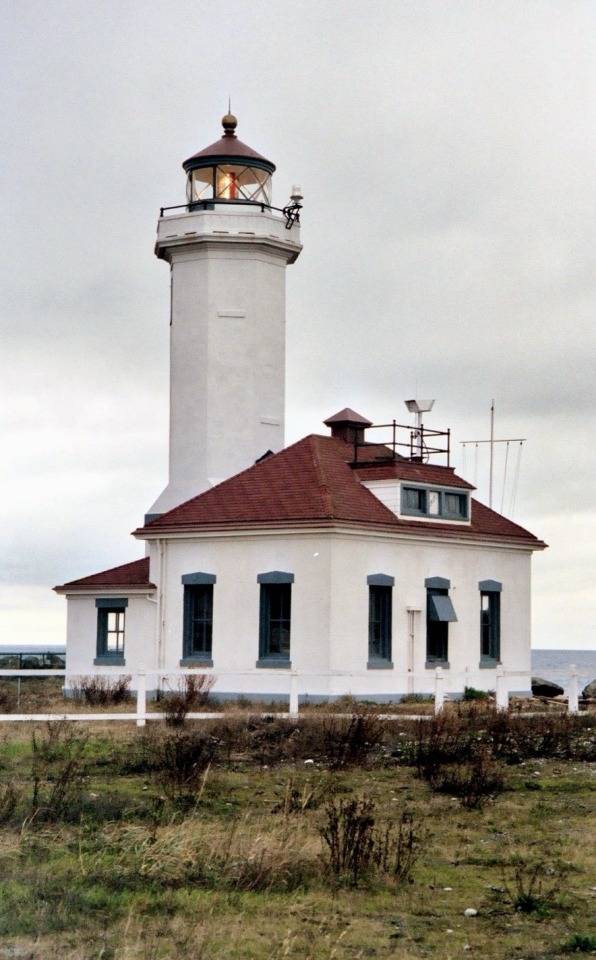
Point Wilson Lighthouse, Port Townsend, Washington, 2004.
#lighthouse#point wilson#port townsend#jefferson county#washington state#2004#photographers on tumblr#pnw#pacific northwest
6 notes
·
View notes
Text
We put the "ass" in "Legalize Medically-Assisted Death".
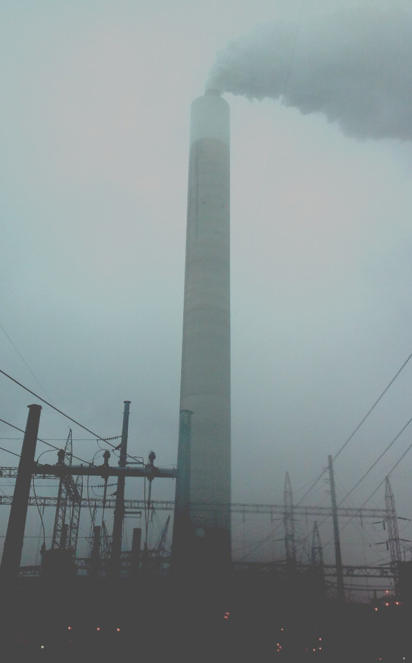
In light of the microburst storm that hit Jefferson County on Friday, June 7, the Jefferson County Assessor’s Office is asking property owners who experienced a casualty loss to their property or had structural damage to all or a portion of their property buildings, to contact the Assessor’s Office immediately and no later than June 24, 2024, as you may qualify for the Property Tax Casualty Loss Exemption, under I.C 63-602X.
View the Casualty Loss Form
#idaho#jefferson county#jefferson id#storm damage#weather#insurance#tax exemption#local government#storm#meteorology#damage
2 notes
·
View notes
Text

A little bit about us: We're owners of 5 separate ONLINE radio stations, that serve the North Central PA Market (Each county is hash tagged below). We also offer advertisement services for local businesses, and want to be a part on the North Central PA community for years to come!
#cameron county#Centre county#Clearfieldcounty#elk county#forest county#clarion county#jefferson county#McKean County#Potter County#Online Radio#NCPA
0 notes
Text
You can’t make this up.
0 notes
Text

7 notes
·
View notes
Text


Peter Skene Ogden State Scenic Viewpoint, OR (No. 3)
The Crooked River Railroad Bridge, part of a BNSF Railway line between the Columbia River and Bend, Oregon, crosses Oregon's Crooked River Canyon in southern Jefferson County. The bridge is 320 feet (98 m) above the river and when it was completed in 1911, it was the second-highest railroad bridge in the United States. It is a steel two-hinge arch span with a total length of 460 feet (140 m).
The crossing of the Crooked River played a critical role in the competition to build a railroad up the Deschutes River Valley. The incentive for railroad construction was reaching the vast stands of timber south of Bend. The Oregon Trunk Railway Company, a subsidiary of the Spokane, Portland and Seattle Railway owned by James J. Hill of the Great Northern Railway, started up the west side of the Deschutes while the Des Chutes Railroad, owned by Edward Harriman of the Union Pacific, started up the east side. At North Junction, approximately 65 miles (105 km) south of the Columbia River, Hill's Oregon Trunk crossed over to the east bank. At 126 miles (203 km) both railroads would have had to cross a major tributary of the Deschutes, the Crooked River. There was only one place where the cliffs on both sides were close enough to build a bridge. Jim Hill had obtained the rights to the location when his Oregon Trunk Railroad acquired the Central Oregon Railroad Company on December 1, 1909. The Central Oregon had laid no track and the rights to the bridge site were its principal asset. Hill's acquisition of the location forced Harriman to negotiate a settlement whereby the Oregon Trunk, Hill's railroad, would own almost the entire line from the Columbia to Bend but Harriman's company would have the right to use the track.
Through a series of mergers the rail line and the bridge became part of the Burlington Northern and Santa Fe Railway (which changed its name to BNSF Railway in 2005). Union Pacific, Harriman's old railroad, still has the right to use the track. Great Northern extended the line south from Bend to Chemult in 1928.
Source: Wikipedia
#Peter Skene Ogden State Scenic Viewpoint#Deschutes County#Jefferson County#Oregon#USA#summer 2023#Pacific Northwest#travel#original photography#vacation#tourist attraction#landscape#landmark#countryside#Terrebonne#Crooked River#Crooked River Railroad Bridge#architecture#engineering#Crooked River Railroad Bridge by Ralph Modjeski#flora#tree#nature#Crooked River Gorge#Crooked River High Bridge#Conde McCullough
8 notes
·
View notes
Text
https://jeffersoncountypropertytaxtrends.com/savings-from-appeals/
Jefferson property tax appealed saved owners $22 MM at informal hearings, $3 MM at ARB hearings and $11 MM through lawsuits in 2021. Learn how to save. https://jeffersoncountypropertytaxtrends.com/savings-from-appeals/
0 notes
Text

Power of a Rainy Day (2) by Epiphany TT1530
3 notes
·
View notes