#LANDSAT
Explore tagged Tumblr posts
Visit Tumblr Blog
Explore Tumblr blogs with no restrictions, modern design and the best experience.
Last Seen Tumblr Blogs


Fun Fact
Premium Tumblr themes are available from anywhere between $9 to $49.
Text
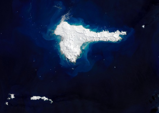
Elephant Island by Landsat 8
“When explorer Ernest Shackleton and the crew of Endurance lost their ship to crushing pack ice in the Weddell Sea in 1915, their chances of survival seemed dim. The 28 men spent months drifting on ice floes and traversing the Southern Ocean in small lifeboats until they finally spotted land. The hunk of rock and ice was not the welcoming refuge they hoped for, but it was enough.
Shackleton and the crew of the Imperial Trans-Antarctic expedition landed on the mountainous, ice-covered island today known as Elephant Island. Some say Elephant Island got its name from the sighting of elephant seals along its shores; others suggest it comes from its appearance as an elephant head. But Shackleton’s captain claimed it was a nickname given by the crew: ‘Hell-of-an-Island.’
The image above shows a rare, cloud-free view of the remote island on December 13, 2020, as captured by the Operational Land Imager (OLI) on Landsat 8. The highest points, Mount Pendragon (970 meters or 3,200 feet) and Mount Elder (945 meters or 3,100 feet), are located on the southern side. In the center, Endurance glacier collects most of the ice flowing in the southeast direction.
Elephant Island is located about 250 kilometers (150 miles) northeast of the tip of the Antarctic Peninsula. Geologically, the island is part of the Scotia Plate, which was formed from continental fragments that once formed a land bridge between South America and Antarctica. The rocky island is comprised of green and blue phyllites, blueschists, and greenschists along the coast and in ridges.
Elephant Island has few plants or animals, save for some seals and gentoo and chinstrap penguins. Although it is in a prime location for observing whales, the island is not well visited and has remained relatively under-studied due to its remoteness and difficult terrain.
Shackleton and his crew initially landed on the eastern coast at Cape Valentine, but falling rocks and the proximity to the sea made it difficult to set up safe campsites. In fact, much of the island’s coastline consists of cliffs with steep slopes rising more than 100 meters (330 feet) in places. Crew member Frank Wild scouted more stable ground to the west, with lower elevation but also more glaciers. The team set up camp, naming the site Point Wild.
Shackleton realized their chances of getting rescued from Elephant Island by passing ships were low, so he and five crewmates took a lifeboat to look for help, leaving Wild in charge.
The remaining crew built makeshift huts by resting their two remaining lifeboats upside down on rocks. To combat the perpetual darkness, they made lamps out of sardine tins, used surgical bandages for wicks, and burned seal blubber oil. Four and a half months later, Shackleton and crew returned with a ship and rescued all 22 men. King George V recognized Wild’s leadership as ‘instrumental in maintaining their courage and hope.’
Today, the island hosts one small research station occupied during the summer. At Point Wild, a monument was erected to honor the crew and their experience on the island.
[Author: NASA Earth Observatory image by Joshua Stevens, using Landsat data from the U.S. Geological Survey. Story by Kasha Patel.]” - via Wikimedia Commons
#picture of the day#picture of the day 12/13/2024#gotta be the longest desc i have ever seen on a wiki commons page#wikipedia#wikipedia pictures#wikimedia commons#nature#nasa earth observatory#u.s. geological survey#ernest shackleton#weddell sea#elephant island#wikipedia picture of the day#wikimedia picture of the day#island#southern ocean#ocean#oceancore#sea#ocean aesthetic#landsat#l
12 notes
·
View notes
Text

The Lake Mungo lunette, New South Wales, Australia
12 notes
·
View notes
Text
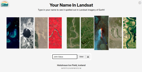
Hey, NASA did a cool thing and put it online, so you can spell things with the Earth:
12 notes
·
View notes
Text

🛰️💧Льодовик Рона у Швейцарії, один із найвідоміших у Європі, за останні десятиліття скоротився настільки, що це стало помітно навіть із космосу. Порівняння знімків Landsat за 2001 і 2024 роки демонструє, як синьо-білі крижані масиви поступилися місцем скелям і рослинності. Вчені зазначають, що з 1973 року площа швейцарських льодовиків зменшилася на 350 км², що еквівалентно втраті 27% їхнього обсягу.
Але танення льодовиків – це не лише екологічна проблема. Вододільні лінії, які визначають кордони між Італією, Швейцарією та Австрією, зміщуються разом із крижаними шапками, що зникають. Наприклад, у 2024 році танення льодовика Маттерхорн призвело до того, що найвища точка гори зрушила у бік Італії, що автоматично змінило кордон на користь Швейцарії. Такі зміни вимагають перегляду міжнародних угод, як це вже сталося між Італією та Австрією у 2006 році. Однак головна загроза криється в іншому: льодовики Альп живлять найбільші річки Європи, такі як Рона та Рейн, і їхнє зникнення може порушити водопостачання мільйонів людей.
🔎 Цікавий факт: кордон України та Румунії також поступово змінюється, але не через льодовики, а через обміління гирла Дунаю внаслідок природних руслових процесів, які прискорює глобальне потепління. Також це створює поступовий дефіцит водних ресурсів у регіоні.
#екологія#ecology#switzerland#alpes#austria#italy#matterhorn#landsat#rhine#rhona#glacier#climate change#global warming#water shortage#Österreich#Schweiz#Gletscher#Ökologie#Klimawandel#зміни клімату#глобальне потепління#альпи#льодовик#італія#австрія#швейцарія#дефіцит води#румунія#україна#дунай
3 notes
·
View notes
Text
tumblr written with landsat images
you can write your name here https://landsat.gsfc.nasa.gov/apps/YourNameInLandsat-main/index.html
2 notes
·
View notes
Text

Landsat 7 history
0 notes
Text
SciTech Chronicles. . . . . .May 20th, 2025
#NASA-Smithsonian#CO2#Landsat#AVUELO#anti-atoms#electromagnetic#superconducting#vacuum#swarms#“water runoff”#caprock#sealed#dynamically#programmable#“outer skin”#efficient#POstick#Kinesthetic#Visuo-tactile#AR
0 notes
Photo
Monitoreo satelital permite detectar cambios en la cobertura forestal de la Amazonía
El Ministerio del Ambiente (Minam) implementa tecnología satelital para el monitoreo permanente de los bosques amazónicos, como parte de sus estrategias de conservación. A través de la plataforma GeoBosques, se procesan imágenes para detectar alertas tempranas de deforestación en todo el territorio nacional.
El sistema, gestionado por el Programa Nacional de Conservación de Bosques y Mitigación al Cambio Climático del Minam, utiliza imágenes satelitales Landsat para generar estas alertas. Según la institución, la plataforma está disponible de forma ininterrumpida, todos los días del año, y puede ser consultada desde cualquier punto del país. Las alertas se actualizan aproximadamente cada 21 a 26 días.
Para verificar las alertas generadas, el Minam emplea imágenes Sentinel, que permiten una visualización más detallada de las zonas afectadas. “El Perú mantiene activas sus capacidades técnicas para la detección de cambios en la cobertura de bosques. Utilizamos imágenes satelitales Landsat para generar alertas tempranas sobre la deforestación, y de manera complementaria, las imágenes Sentinel para su verificación visual”, indicó Daniel Castillo, especialista del Programa Bosques.

El sistema, gestionado por el Programa Nacional de Conservación de Bosques y Mitigación al Cambio Climático del Minam, utiliza imágenes satelitales Landsat para generar estas alertas. (Foto: Minam)
Las imágenes Landsat cuentan con una resolución espacial de 30 metros, mientras que las Sentinel alcanzan los 10 metros. La combinación de ambas fuentes de información y el uso de algoritmos especializados permiten un análisis más preciso, incluso en áreas de difícil acceso.
Acceso libre y utilidad para la gestión pública
GeoBosques es una herramienta de acceso público que ofrece información actualizada a comunidades locales, gobiernos regionales, municipalidades y organizaciones de la sociedad civil. Su uso facilita la toma de decisiones informadas y la planificación de acciones para la conservación forestal.
El Minam también trabaja en la generación de información sobre actividad, usos y cambios de uso del suelo, que servirá como base para reportes técnicos nacionales e internacionales. Entre ellos se encuentran el Nivel de Referencia de Emisiones Forestales, el Reporte Bienal de Transparencia, el Inventario Nacional de Gases de Efecto Invernadero y procesos asociados a REDD+.
Limitaciones recientes en el monitoreo satelital
Sin embargo, el 4 de mayo, un informe de OjoPúblico reveló que el Minam ha perdido el acceso a imágenes satelitales de alta resolución proporcionadas por la empresa Planet, utilizadas durante los últimos cuatro años para mejorar la precisión en la detección de deforestación. Esta pérdida se debe a que el gobierno de Noruega decidió no renovar el contrato del proyecto NICFI, que financiaba el acceso gratuito a estos datos. Como consecuencia, la plataforma GeoBosques ha vuelto a depender únicamente de imágenes Sentinel, cuya menor resolución limita la capacidad de identificar cambios sutiles en la cobertura forestal.
Esta situación también afecta el cumplimiento de compromisos internacionales. Según el mismo informe, Perú ha tenido retrasos en la entrega de reportes sobre deforestación exigidos por la Convención Marco de las Naciones Unidas sobre el Cambio Climático. Expertos advierten que la falta de información actualizada pone en riesgo el acceso del país a financiamiento climático, al dificultar la demostración de avances concretos en la reducción de la pérdida de bosques.
Lea la nota original aquí o visita el medio Inforegión
Red de Medios Regionales
via https://pachamamaradio.org/monitoreo-satelital-permite-detectar-cambios-en-la-cobertura-forestal-de-la-amazonia/
0 notes
Text
I wrote my username with Landsat images 🌎🛰️! You can try with your own name here:
https://landsat.gsfc.nasa.gov/apps/YourNameInLandsat-ma
[Image description: “CJBOLAN” spelled out using Landsat images to represent each letter. End description.]
0 notes
Text

NASA’s Earth Day Poster for 2025 uses imagery from the Landsat satellite mission to spell out "EARTH DAY" and celebrate our home planet
image courtesy NASA/USGS/Landsat: X


Happy Earth Day!
NASA’s Earth research site: X
79 notes
·
View notes
Text
Desvelando los secretos de los planetas: la Teledetección
La teledetección espacial es una técnica que utiliza satélites u otras plataformas en el espacio para recopilar información sobre la Tierra mediante la detección y medición de la radiación electromagnética reflejada o emitida por la superficie terrestre. Esta técnica permite obtener datos sobre diferentes características del medio ambiente, como la cobertura del suelo, la vegetación, la…

View On WordPress
0 notes
Text
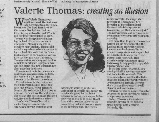


Valerie L. Thomas (born February 8, 1943) is an American data scientist and inventor. She invented the illusion transmitter, for which she received a patent in 1980. She was responsible for developing the digital media formats that image processing systems used in the early years of NASA's Landsat program.
#black tumblr#black history#black literature#black excellence#black community#civil rights#black history is american history#civil rights movement#black girl magic#blackexcellence365#american scientist#inventor#college education#american data scientist#patent#image processing#illusion transmitter#nasa#nasa landsat program#black girl#black girl motivation#morgan state university
1K notes
·
View notes
Text
I don’t have a posted DNI for a few reasons but in this case I’ll be crystal clear:
I do not want people who use AI in their whump writing (generating scenarios, generating story text, etc.) to follow me or interact with my posts. I also do not consent to any of my writing, posts, or reblogs being used as inputs or data for AI.
#not whump#whump community#ai writing#beans speaks#blog stuff#:/ stop using generative text machines that scrape data from writers to ‘make your dream scenarios’#go download some LANDSAT data and develop an AI to determine land use. use LiDAR to determine tree crown health by near infrared values.#thats a good use of AI (algorithms) that I know and respect.#using plagiarized predictive text machines is in poor taste and also damaging to the environment. be better.
293 notes
·
View notes
Text
A Website/meme shared on Dreamwidth:
Your Name (or any word, really) Spelled out in Landsat Images from NASA
Type your name, or any phrase you want (in Latin Alphabet Letters), and you'll get a string of images of those letters as seen from space.
You can download the image in .png format, or, like I did, screen cap and crop. Here's "CapricornOmnikorn:
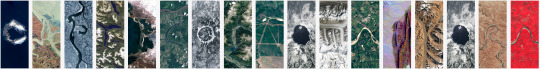
And here's "love you":
On the website, if you hover over each letter, it will tell you where on Earth it is.
46 notes
·
View notes
Text
I'm normally terrible at explaining why I like something, including my entire major. So usually when people ask me why I like GIS my gut response is "it's versatile." Which yeah, true, but it feels way more... I don't know, industrial I guess, to say that I'm only getting this degree for the job prospects.
I think a more accurate reply would be that it's an art form I like, but given that most people don't even know what GIS is and ask me what it means all the time, I think it would fly over their head so I don't normally bother. As awfully presumptuous as it is
#have you ever had the pleasure of leveling a total station to the nearest hundredth#or adjusted the magnetic declination of a compass to get the approximate location of your location on a map by taking two or more azimuths#the pain of downloading landsat imagery thsy takes 83757485638 years#ramblings
2 notes
·
View notes