#Easements
Text
Exploring the Basics and Importance of Land Surveying!
Land surveys are important tools in the realm of real estate, construction, and land development. They serve as the foundational blueprint for understanding and utilizing pieces of land effectively. A land survey involves the precise measurement and mapping of a property's boundaries, topography, and features. These surveys are conducted by licensed land surveyors who employ various techniques to provide accurate and reliable data. What is Land Surveying?
Land surveying is the process of measuring and mapping out the land. Surveyors use a combination of mathematics, technology, and physical observation to determine the boundaries and features of a piece of land. This information is crucial for creating accurate maps, planning construction projects, and resolving property disputes.

What, Exactly, Does a Land Survey Find? Here's a Step-by-Step Look at How Our Experienced Team at Dolphin Engineers Conducts a Land Survey: First, it allows you to determine the precise boundaries of your property. This information can allow you to identify the locations of structures, additions, and improvements to your property. Second, it can find the slopes and other geographic features of a property. This information may be helpful for a property owner who is planning to build more on their land and needs to know its features. Third, it finds the locations of easements and utilities. Easements offer the right to use someone else’s property for specific reasonsFinally, a land survey can identify whether the land is a floodplain. This is very good information to know before buying a property, to avoid accidentally acquiring property that is prone to flooding.
Tools and techniques used for major land surveys include theodolites for measuring angles, GPS units for location data, and total stations that integrate the functionalities of both. Drones are used for aerial surveys, capturing detailed images and data. These tools and techniques enable highly accurate and reliable surveys. Why Choose Dolphin Engineer for Your Land Surveying Needs? At Dolphin Engineer, we pride ourselves on our accuracy, professionalism, and commitment to customer satisfaction. Our team of experienced surveyors uses the latest technology to provide precise and reliable surveys for all your needs. Whether you're planning a new construction project, resolving a property dispute, or simply need an accurate map of your land, we're here to help. At Dolphin Engineer, we're dedicated to providing high-quality surveying services that you can trust.
If you have any questions or need a survey, don't hesitate to contact us. visit our website for information- https://www.dolphinengineers.com/.
#LandSurveying#PropertyBoundaries#LandDevelopment#ConstructionPlanning#DolphinEngineers#SurveyingTechnology#AccurateSurveys#PropertyDisputes#TopographicSurveys#Easements#FloodplainIdentification#ProfessionalSurveyors#RealEstateSurveying#SurveyingServices
0 notes
Text


I like this "farm". Very blue. 5 acres on the Jersey shore with a house & barn for $450,000. Cheap for New Jersey. If I sold the shore house, I could buy this and probably have $50k left over to fix the hideous bathroom and put up a fence and a run-in for Amba. It's not directly on the water, but for hurricane-related reasons that's probably a good thing. The view of the marsh from that one room still gives it cheerful sea shore vibes. At least 3 acres look very flat and useable for horses and flower farming. I'm getting ideas in my head lol. The only down side that I see aside from a few rooms in the house needing fixing is just the size of the home. It would be a lot for just myself to clean and take care of. But I'm going to save it and keep and eye on it. Let's see if it's still around when this semester is over and I graduate.
36 notes
·
View notes
Text
‘potential loustat kisses for season 2’ post that I made back in January getting notes again makes me want to create a list of unhinged loumand kisses as counterpoint/companion piece
#original post had Loumand art gallery kiss and tower kiss in the tags and honestly? not creative enough#I’ve written Easement since then I can do better
16 notes
·
View notes
Text
#6353
Make an epic moment
Worth written in a parchment
And be read with easement.
3 notes
·
View notes
Text
Easement
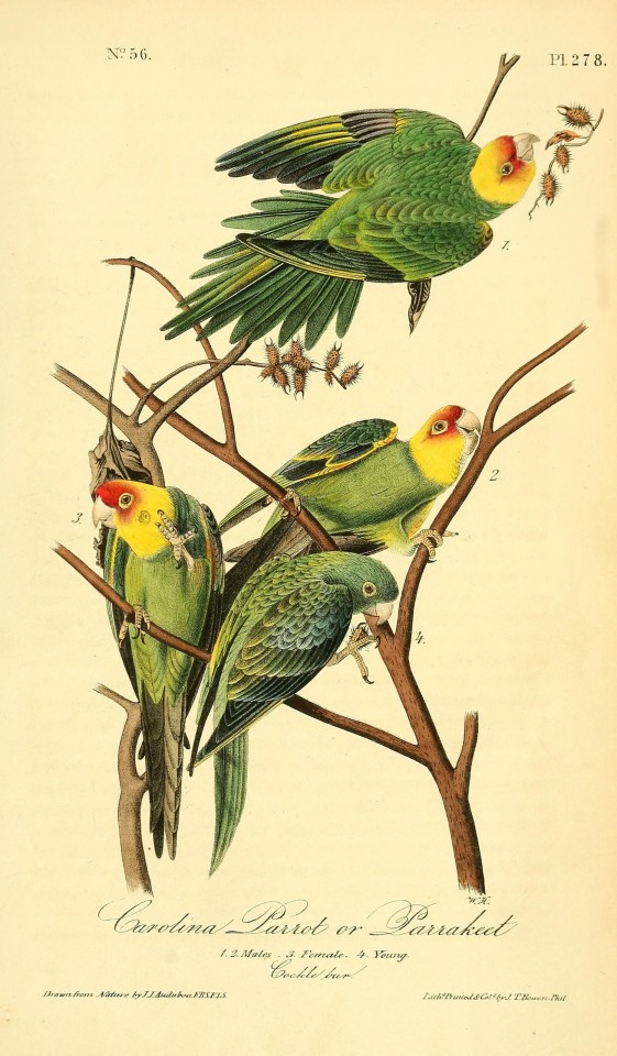
I did not see a parakeet. Nor did I expect to because the last time anyone saw the kind I could have seen was one hundred years ago. But had I seen one, it would have had a green body, a yellow neck, and a red crown, like a granny smith apple, turning into a golden delicious, ending with a fuji flourish. Unlike apples though, this parakeet would have been indigenous. Back in his day, Audubon fixed four of them, all on a branch of matured cocklebur, their name swirling below–Carolina Parrot or Parakeet—just as live ones would have swirled above and outside his page, until they all passed (a century later) into life only re-presented (drawings, pictures, reminiscence, taxidermy).[1] So, I did not see a parakeet.
But I did see cane, as I was in a canebrake. Switchcane, rivercane and hill cane, the genus Arundinaria trio, bamboos native to North America. I am not sure which species of cane I was in, though my guess is switchcane (A. tecta), as rivercane (A. gigantea) also has the name of giant cane for its remarkable height—at maturity it is taller than a grown man on a grown horse; and hill cane (A. appalachiana) has a topographic preference that did not describe the place where I stood.
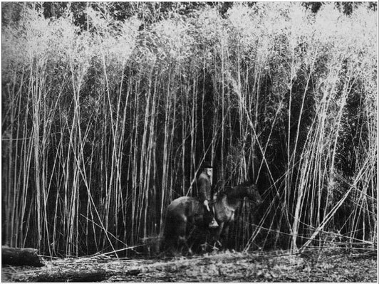
Nevertheless, they all look similar, more like plants in diagram rather than plants in dirt, their linear stems appear pencil drawn, their lance like leaves seem generated by straight edge. Enmassed, canebrakes look like early computer-generated greenery before sinuosity was possible. In a way, they are an early plant—a fire rolls through, clears the understory, perhaps takes a tree or two down with it; the flames cease and cane is among the first to resurface, and resurface quickly for it is not as dependent on reseeding as it is on its rhizome.[2] Like the longleaf pines which it once accompanied over the land, it looked forward to the fire next time. Out of the flames came thickets, which though they may have barred other plants, they were quite welcoming to Carolina parakeets, warblers, “cougars, bobcats and wolves” canebrake rattlesnakes, creole pearly eye butterfly and untold others.[3] Walls of cane were a kind of mass housing for the many migrant, squatter and settling organisms of the southeast. They (particularly river cane) also provided materials of home and place making for humans, as their straight stems were (and still are) gathered by Native American communities especially the Cherokee.[4] Once hollowed out, canes can become basket or blowgun, mat or flute, or—as has become a rustic object— fishing poles. There are not many significant canebrakes today. Cattle ate them, draining and development cleared them, fire suppression stymies their return; the scattered groupings I see along the road are remnants of a lost empire, holding out amidst a concrete ground that stifles them, a dense forest that smothers them, and farmland that suppresses them. But unlike the parakeet they remain. Though, like the parakeet, I was not in the canebrake to see the cane—it fortunately just happened to be there.
I only saw the canebrake, because I was in a conversation easement, which I only noticed because of a small, yellow, all caps sign—"NORTH CAROLINA SOIL AND WATER CONSERVATION EASEMENT BOUNDARY”. “Easement” is one of those legal terms that I knew more by general use than specific meaning. Modified by the word “conservation” easement suggested the land was protected, but why, by who and to what extent was unclear until I looked it up later. The NC Department of Environmental Quality defines conservation easements as: “voluntary legal agreements designed to ensure the long-term viability and protection of the natural resources within a surveyed and recorded boundary. The easement planning process establishes allowances and restrictions that are beneficial to the landowner, the easement holder, and the environment.”[5] The conservation easement then is not foremost a means of protection, but (much more interesting I think), it is a way of organizing layers of rights and access upon a property. Someone owns the lands, but the easement gives some else a right to use it (or not use it, in a way, when conservation is the right being exercised) which in turn inflects the rights and possibilities of both the one who possess the land and others (like myself) who neither own the land, nor hold an easement, but still gain some benefit from the easement’s existence (i.e. enjoying a now rare landscape feature).[6] The yellow sign that alerted me to presence of the easement was nailed into a sweet gum tree. In the FAQ for conservation easements one of the questions asks: “Are there way to precisely identify the boundaries of a conservation easement?”
The answer:
As part of the restoration project, all easement corners were surveyed and monumented in the ground with metal rods. Most of these rods are also topped with 2” diameter aluminum caps. DEQ also uses a variety of methods to post easement boundaries including signage, metal posts, and tree blaze. These may be a witness post or witness tree, located near the line but not the exact location of the boundary.[7]
In some ways, my studies right now could be described as figuring out the extra-legal work of these “witness trees” and their “artefacted” forms into “witness posts” (and columns and panels and all sorts of other wooden things that “witness” human contracts and contact).[8] It gave me pause then, after reading the FAQ to realize that I had witnessed a witness tree that still witnesses (instead of being one in a historical document or text), but that in the moment the sweet gum’s legal function had not even registered to me. I was much more taken by the train of ants along its trunk likely extracting honeydew from aphids up in the canopy, and by the trail of Virginia creeper going up further than the ants, in search of its own luminous food. From the tree’s perspective, witnessing a survey has been only one frame in a very long film still being made around, and around and around it.
In truth, I did even see the easement sign until I was near the tree. And the reason I was near the tree is because a few feet away from it, along the road was the initial object of my attention—a set of black and yellow object marker signs denoting some feature adjacent to the road, a feature which is this case was a culvert underneath the road. Culverts, in their projecting pipe form look like engineering/infrastructural litter, debris left over from a drainage project. In addition to being the ugliest kind they are also the cheapest and least efficient—they do little to channel a flow directly into their opening, which limits how much comes out their exit, potentially leading to the water overflowing the road. Luckily, the culvert I came to see is the recessed box kind with wings extending on its side to welcome water into its inlet, guiding it towards its outlet.[9] Embedded in the earth, moss covered, and a bit worn, there is a minimalist beauty to this kind culvert that does not readily betray the complexity of its task at once to convey ground traffic above and the traffic of water underneath. On the outlet side, some of the water pooled, its clear bottom supported small fish and tadpoles, while its silty edge moistened mosses and grasses and a bit further up also the canes. The water this culvert channels comes from the Indian Branch River, which drains into Deep Creek River, which drains into the Tar River, which drains into the Pamlico Sound, which joins the Atlantic Ocean. Follow these larger waters and you’ll find the larger history of the canes and the Cherokees, the parakeets and the many trees which have witnesses the work of so many kinds of settling, the human version being the most recent, but likely not the last. Though we often like to think otherwise, our homes and other feats of building are ultimately done under a kind of “natural easement”, the land allows us access for a while, but as all the other prior communities of plants or persons show, no claim of possession is final, no root is long and deep enough to always remain (though many can be long remnant). Maybe I will be able to spend a good deal of my life following these state and nation spanning roots, weavings, waters and rhizomes.
But it is not yet time to go so far out. Afterall, the only reason I saw the signs for the culvert, which put me in range to see the blaze on the tree, which brought me close enough to see a canebrake, which led me to imagine what it would be like to still be able to see parakeets, was because I pass the culvert nearly every day when I am home. Fifteen hundred feet from the front door, I have crossed this place many times running, enjoying the brief respite of shade provided by the gums before the land opens again for the farms; and I have driven by it many more times on the way to town, the car bouncing lightly over the culvert. So, I have noticed this spot for nearly thirty years, but this is first time I have “witnessed” the three hundred years of history flowing and growing in it. Either part separately is valuable—to live in a place and feel its features or to come to a place and learn its features, nesting sensations (the shade of the trees, the bump of the road…) or nesting histories (extinction, settlement…). But to bring them together, may, for a moment sustain that special sense which is just able to catch an apple-colored dart zipping across the far end of the eye.
Photos
[1] The Carolina Parakeet, once common from New York down to the Gulf of Mexico, seems to have gone in the first half of the 20th century. The last documented one, named Incas, died in captivity in 1918. It is unclear exactly why it went extinct though habitation destruction seems part of the problem. See: https://johnjames.audubon.org/last-carolina-parakeet and https://www.smithsonianmag.com/science-nature/why-carolina-parakeet-go-extinct-180968740/
[2] There is strong interest in canes and restoring canebrakes. For a general overview see: Barret, Richard; Grabowski, Janet; Williams, M.J. "Giant Cane and Other Native Bamboos: Establishment and Use for Conservation of Natural Resources in the Southeast" U.S. Department of Agriculture, Natural Resources Conservation Service, 2021. For a 18th account of cane use in North Carolina see: Lawson, John. A New Voyage to North Carolina. London: 1709. Digitized at https://docsouth.unc.edu/nc/lawson/menu.html. Lawson recorded many ways that cane was used by the Cherokee.
[3] See: Platt, Steven G., Christopher G. Brantley, and Thomas R. Rainwater. “Canebrake Fauna: Wildlife Diversity In A Critically Endangered Ecosystem.” Journal of The Elisha Mitchell Scientific Society 117, No. 1 (2001): 1–19.
[4] For contemporary work to maintain these traditions see: https://theonefeather.com/2012/05/22/river-cane-important-cherokee-cultural-staple/
[5] See: https://www.deq.nc.gov/about/divisions/deq-administrative-divisions/north-carolina-stewardship-program/living-your-conservation-easement#Aretherewaystopreciselyidentifytheboundariesofaconservationeasement-8672
[6] Though my enjoyment in this case was not a right because this easement is not public (i.e., I was trespassing).
[7] See link on note 4.
[8] Other have already done some of this work. See for example: Miller, Daegan. This Radical Land. Chicago: University of Chicago Press. 2018.
[9] Here is a wonderfully informative video on culverts: https://www.youtube.com/watch?v=15XJDmawbYU
Images:
Carolina Parrot or Parakeet” in The Birds of America: From Drawings Made in the United States and Their Territories Volume 4. John James Audubon. New York: J.B. Chevalier, 1842. p.306.
Image 3208 (Canebrake in Northeast Louisiana early 1900’s). USDA Bureau of Plant Introduction. See note 2 for source.
6 notes
·
View notes
Text
Thanks to @darkisrising for recommending Epic Fantasy playlists to work to. 😯
This has made my day immeasurably better.
7 notes
·
View notes
Text
writing my novel for myself and myself only
#it only has to make sense to me#i dont care dude im so tired of censoring what i write for the easement of others
4 notes
·
View notes
Text
living on a property with an easement is strange sometimes. the local power company has been doing work back there all summer and I am REALLY tired of waking up to construction noise and listening to it all day.
#talking#BLEH#like they notified us and everything they're totally legal to be doing it and the work needs doing but god. annoying.#the helicopters earlier in the spring when they were mapping (?) the area was also very weird and unpleasant#and today my grandma is all freaked bc they're running chainsaws and shes concerned about our trees...#and it's like yeah that would suck but legally if they need to take down trees on the easement they're allowed
2 notes
·
View notes
Text
I got polls so now it's time to do dialect stuff! Add in the tags your answer and where you're from! And remember, no right or wrong answers since there's literally no reason to call this any of these over the others, language is arbitrary but also rad as hell.
#linguistics#dialect#dialect variation#linguistics polls#dialect polls#accent#tree lawn#curb lawn#easement#etc.#i hope i find new ones bc this is literally my favorite dialect variation map for things i love it so much
3 notes
·
View notes
Text
NIMBY
You may have heard of this term. NIMBY is short for 'Not in my backyard'. The PCT was officially identified in 1968 but it wasn't until 1997 that the 'golden spike' marked an official completion of the trail. On paper this sounds great, doesn't it? A complete 2,650 mile ribbon of trail that stretches from the California/Mexican border north to the Canadian/Washington state border.
Well, not so fast. Even today, fifty-five years after its official designation as one of two (at the time) National Scenic Trails, sharing the spotlight with the Appalachian Trail in the east there are many miles that are very restrictive for hikers passing through.
Approximately 10 percent of the trail remains on private land with little in place to help protect the trail experience for future generations.
In a majority of cases, trail easements exist through these private parcels that allow hikers and equestrians the right to pass through. However, many of these very narrow easements are less than 30 feet wide. As a result these easements do not provide any real protection for the land adjacent to the trail. Of particular notice is that new construction and development can happen at any time on private property along the PCT.
As a result, the wildness of the trail experience is compromised every time a new road, power line or vacation home is built nearby. Often, these developments can and do push the trail onto property edges and along large fence lines if there’s no other place for it.
The PCTA continually advocates for increased federal funding for land protection and has been doing so since 1999. One avenue to gain access to these restricted lands has been through the Land and Water Conversation Fund (LWCF). Congress has been strongly urged to provide full funding for the LWCF. Yearly, $900 million from energy company royalties on offshore oil and gas drilling leases are put into the LWCF. This money is intended to create and support parks and waterways. Unfortunately, Congress typically designates only a small portion of this money for the intended purpose and instead diverts most of the LWCF money to other unrelated spending.
Over the past 18 years, almost $46 million in LWCF funding has been used to acquire and permanently protect just over 33,000 acres along the PCT.
LWCF dollars are essential to permanently protecting the last 10% of private lands along the PCT. While there have been many successes in recent years, thanks to the hard and devoted work of the PCTA, LWCF appropriations have not been adequate to keep up with the number of landowners willing to sell their property along the PCT. Opportunities to purchase some of these properties constantly come and go, and in some cases could be our last chance to protect critical lands.
Here's what you can do. To show your support, please take a moment to contact your congressional representatives and let them know that you support full funding for LWCF and the protection of the Pacific Crest Trail. Make the PCT the gem that it is by striving to keep it in all of our backyards.

4 notes
·
View notes
Text
I'm suffering bc my body decided to forget to breathe so I'm having to do it manually and my chest hurts so much bc of it
6 notes
·
View notes
Text
Sydney Water Acquisition Easement | Expert Legal Guidance
Learn about Sydney Water acquisition easements and how our expert legal team at Newhouse & Arnold can assist you with navigating the complexities. Get personalized advice and support tailored to your needs in Sydney.
#land acquisition lawyer sydney nsw#land acquisition architect#property lawyer#land resumption lawyer sydney nsw#franchise lawyer sydney#land and environment court lawyers#Sydney Water Acquisition Easement
0 notes
Text
Is It Legal to Sell Landlocked Property? Understanding the Rules and Regulations

When it comes to real estate, a landlocked property is one that does not have direct access to public roads or streets. This can present unique challenges for both buyers and sellers. Understanding the legal implications and regulations surrounding the sale of landlocked property is crucial for making informed decisions. In this blog, we'll explore whether it's legal to sell landlocked property and what you need to know about the rules and regulations.
is it legal to sell landlocked property
What is Landlocked Property?
Landlocked property refers to a parcel of land that is entirely surrounded by other properties, with no direct access to public roads. This lack of access can make it difficult to reach the property, which may affect its value and desirability.
Is It Legal to Sell Landlocked Property?
Yes, it is legal to sell landlocked property. However, selling such a property comes with specific challenges and legal considerations. The key issues typically revolve around access rights and easements.
Key Legal Considerations for Selling Landlocked Property
1. Easements
An easement is a legal right to use someone else's land for a specific purpose, such as accessing your landlocked property. There are different types of easements, including:
Express Easements: These are written agreements that grant access across another person’s property. Express easements are often recorded in public records and are legally binding.
Implied Easements: These are not written but are assumed based on the circumstances, such as historical access to the property.
Easement by Necessity: This type of easement is granted when a property is landlocked, and the only way to access it is through another property. Courts may grant this easement if it is deemed absolutely necessary for the use of the landlocked property.
2. Obtaining Access Rights
If the landlocked property does not currently have an easement, the seller or buyer may need to negotiate with neighboring property owners to obtain one. This process can be time-consuming and may involve legal proceedings if the neighboring property owners are unwilling to grant access.
3. Disclosure Obligations
In most states, sellers are required to disclose any known issues with the property, including the fact that it is landlocked. Failure to disclose this information can lead to legal complications, including potential lawsuits from the buyer.
4. Impact on Property Value
The landlocked status of a property can significantly affect its value. Buyers may be hesitant to purchase a property without guaranteed access, and lenders may be reluctant to finance such a purchase. As a result, landlocked properties often sell for less than comparable properties with direct access to public roads.
Tips for Selling Landlocked Property
Secure an Easement: Before listing the property for sale, try to secure an easement for access. This can make the property more attractive to buyers and simplify the sales process.
Work with a Real Estate Attorney: Given the legal complexities involved, it’s advisable to work with a real estate attorney who can help navigate the process and ensure that all legal requirements are met.
Be Transparent with Buyers: Clearly communicate the landlocked status of the property to potential buyers. Providing information about existing or potential easements can help build trust and avoid future disputes.
Consider the Buyer’s Perspective: Buyers will need to consider how the landlocked status affects their plans for the property. Being prepared to address their concerns and provide solutions can facilitate a smoother transaction.
Conclusion
While it is legal to sell landlocked property, doing so requires careful attention to legal details, particularly regarding access rights and easements. By understanding the rules and regulations and taking proactive steps to address potential issues, you can successfully navigate the sale of a landlocked property. Whether you’re a buyer or seller, working with professionals, such as real estate agents and attorneys, can help ensure a smooth and legally sound transaction.
#Here are some tags for the blog:#- Landlocked Property#- Real Estate Legalities#- Easements and Access Rights#- Property Sale Challenges#- Real Estate Regulations#- Selling Landlocked Property#- Property Access Issues#- Real Estate Disclosure#- Landlocked Land#- Property Value Impact
0 notes
Text


The inside of my brain while I was writing Easement btw
13 notes
·
View notes
Text
#5278
Remember the payment
Before thinking of easement.
Else, there is a punishment.
4 notes
·
View notes
Text
PROPERTY LAW YESSS I LOVE YOU EASEMENTS!!!!
0 notes
Last Seen Blogs

foodileadventures
The Foodile Adventures

egchord
hip - stah

pabriktassouvenirmurah-blog
081223570407 Grosir Tas Souvenir Surabaya Sidoarjo

fonfii-blog1
fonfii

mitchelljones
sexy youngster looking for love