#Climate map
Explore tagged Tumblr posts
Text
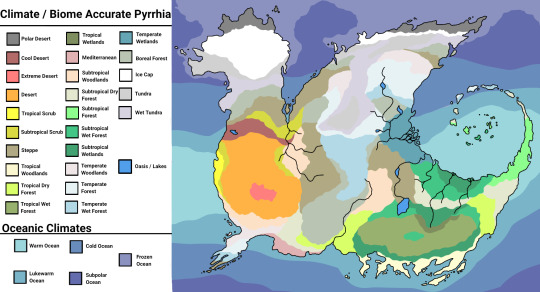
I am insane... But look, climate-accurate Pyrrhia, all because I hated the transition from the ice kingdom to the sand kingdom-
#alo art#wings of fire#wof#wof headcanon#pyrrhia#cartography#Climate map#headcanon#seriously what is wrong with me#i have too much time on my hands
2K notes
·
View notes
Text
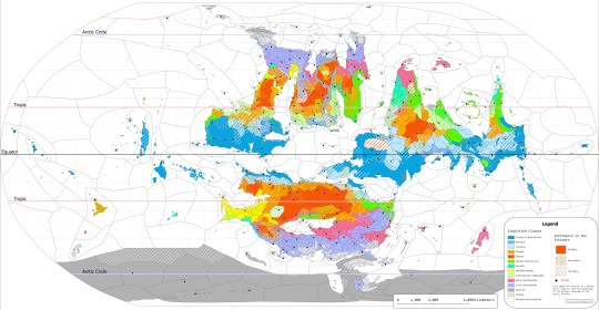
Climatic Map of the 4th World (zooming in is preferable, both to read the key and the names of cities)
7 notes
·
View notes
Text


In addition to my handmade maps, I also create climate maps based on the Köppen Climate Classification system!
you can check me out at solomonscompass.com and on Etsy, Instagram, and Facebook.
#fantasy#fantasy map#worldbuilding#dungeons and dragons#D&D#fantasy worldbuilding#writing#climate map#mapmaking#mine
6 notes
·
View notes
Photo
Is it really comparing Oahu to Mogadishu? I know it's a hot summer but we still have some moisture here.
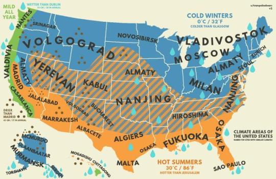
US climate with equivalent cities from around the world.
Keep reading
80K notes
·
View notes
Text
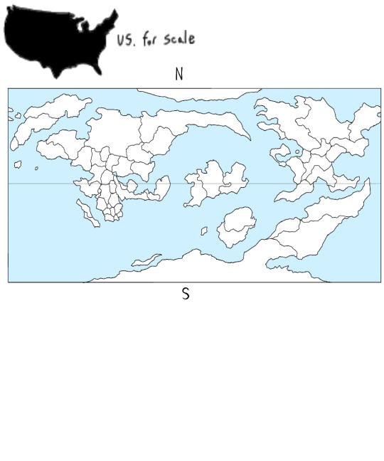


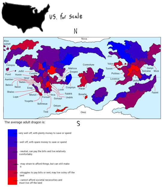
WORLD BUILDING
WORLD BUILDING
WORLD BUILDING
WORLD BUILDING
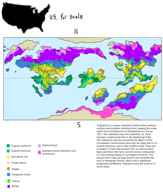
This is my favorite part of any story smhhh like climate maps? Population maps? Labeled maps? It's my fuckin jam. This isn't gonna be for any actual written story, it's just for a story in my head. The sole author/director/audience all in one ♡
It's gonna have all my favorite things! Twisted moral-less gods, cult themes, cannibalism, ritual sacrifice~
#PLEASE please please send me asks about this world I'm frothing at the mouth with information#original world#World map#Fantasy world#Fantasy world map#Original world map#Fantasy map#Climate map#Wealth map#Population map#Dragon world#You wouldn't believe how long I've been staring at climate and population maps online#Just for references#At first the planet was gonna be bigger than earth#But mass correlates directly with gravity#So a larger planet would have more intense gravity ofc. That would get in the way of flying lol#So now it's a little bit smaller than earth!#World building#My works
1 note
·
View note
Text
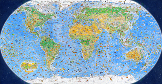
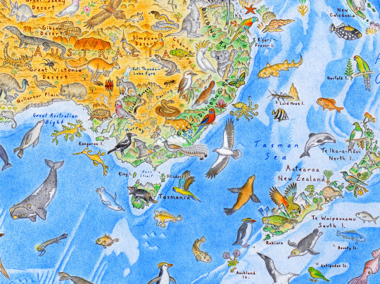
More than 1,600 Hand-Drawn Animals Roam the Earth in Anton Thomas’s ‘Wild World’ Map
949 notes
·
View notes
Text

Here's a heavily improved Imperial Wardin map, with a focus on climate and geography (uses the Koppen Climate Classification). This is an attempt to infuse pre-existing lore too established to retcon with a degree of realism, but there's only so much I can do.
The majority of the climate falls under the hot mediterranean and semi-arid classification, with small pockets of warm mediterranean and arid climes. The entire region experiences a rainshadow effect from the eastern Blackmane Mountain range, which blocks northeasterly winds from the eastern ocean and starkly divides the Sub-Viper landmass between its humid east and dry west.
Most of the interior is grassland, savannah, and scrub. Savannah heavily coincides with a history of human occupation and controlled burns, and is mostly based around oak. Grassland, scrub, and semi-desert dominates the semi-arid regions. Small pockets of high desert and salt flats occur in the arid zones.
A forest originally spanned much of the north, consisting of predominantly oak. This was gradually eliminated due to multiple factors- a warming climate, low intensity human intervention (hunter-gatherers and pastoralists clearing land with controlled burns), and high intensity exploitation (deforestation for timber). Additional woodlands found along the major riverways have been wholly eliminated by logging within the past several centuries.
The largest remaining span of woodland occurs within and north of the Highlands, and in the sparsely populated northeast, where a major and mostly intact oak forest stretches to the Blackmane mountains. A smaller pocket of woodland occurs in the volcanic highlands of Lobera. Other pockets remain, but are isolated and insignificant on the map.
Most of the geography is flat, divided by a range of hills that are the heavily eroded remains of an ancient mountain range. The highest peaks of this range comprise the contemporary Highlands, which have the highest elevations and coldest climate in the region. This is the only territory that regularly receives snowfall, and is the source of several major rivers. The rest of the range is too low to drastically affect the climate, save for the Red Hills east of the Cholemdi basin, whose rain shadow effect (heavily compounded by the basin's low elevation) renders this valley the hottest and driest part of the region. This range once formed a land bridge across the Viper into Finnerich (though this was prior to anatomically modern humans Existing) with its only remnants being smatterings of islands.
The province Lobera holds a small range of volcanic highlands, composed of a network of mostly dead volcanic craters. The volcano Odatoche is the only active site in the region, though has been dormant for centuries and has not had a major eruption in millenia. The other major geological feature is the Sons of Creation, which is the fabled site of God’s self-sacrifice from which the world was made. This is the eroded range of a very large impact crater, consisting of two impact rings (visible as a circular formation of hills) a ring lake, and an elevated center.
The most fertile land is found in Ephennos, owing to the presence of the Black River and its highly fertile delta (which contains the only major semi-permanent marshes outside of Highland river valleys). This is the second largest river in the region, being a confluence of two major river systems out of the Highlands (the Urbin/Erubin and Troibad/Nedachemi rivers). Erubinnos has the largest river, the Kannethod, which originates in the Blackmane mountains.
Agriculture around some of the other river systems is mostly or entirely dependent on their post-rainy season flooding. The most prominent is the Yellowtail river (flows south past Erub). In the very distant past, this was the longest river in the region, and carved out the Cholemdi basin and reached the sea. In the contemporary, it dries out long before even approaching the sea (though occasionally still floods the basin in abnormally rainy years). The Brilla river system out of the Red Hills (flows to Wardin) reaches the sea year-round, but has been known to run dry in exceptionally severe drought, and irrigation along its length depends on its flooding.
There are very few significant lakes in the region (small lakes are unmarked). The biggest is the volcanic crater lake Aganagarre in Lobera, the Yellowtail lake north of Erub, and the ring lake within the Sons of Creation.
#The last map of the region I posted is now obsolete. Ignore it#Idk if I've given the impression that it's partly like. High desert but it's not. I based a good chunk of its climate off the north america#southwest (though much bigger chunks fall into the mediterranean climes than the SW does)#I wrote in the Highlands after climbing Wild Rose Peak in Death Valley. Just kind of inspired by the experience of being#there in February and the temps being 80-90 degrees but then climbing a few thousand feet and suddenly its way cooler and there's#cacti covered in snow.#(I live in a region that is mostly flat and at low elevations so encountering Basic Mountain Effects was mind blowing)#When I say 'based on' it's not directly based. I kind of just get a sense of each region's climate and then find as many irl analogues#as possible to get an idea of how it would work. That is the only subtropical/semi-arid mountainous region I've ever Been to though#Otherwise I've seen the Scottish and Icelandic highlands which are not even slightly analogous.#Oh and the north shore highlands which I kind of forget are a Thing and it's not just lake effect. Not even slightly analogous either.#imperial wardin
85 notes
·
View notes
Text
You really should know about Storm "Daniel"
Unlike how much all of us Greek blogs notify our tumblr communities about the regular (at this point) arsons wildfires afflicting Greece, we did not say much about the floods the country has been suffering from right now. There was a mention here and there and I even made a joke post as the storm was starting but not a lot of stuff in general. So, I think there's a couple of things you should know and I feel like I could address about it and actually it's not just about Greece. So I believe this could interest a lot of people and it should be something known worldwide.
In the beginning of September there was an alarm about an extreme weather phenomenon forming above the Ionian Sea at the west of mainland Greece. In truth, the phenomenon was not caused by the climate change. It was just a very rare occurence where a high pressure atmosheric system was sandwiched between two currents of low pressure. Low pressure systems are the ones resposible for stormy weather while high pressure systems generally create stable weather. As the low currents encircled the high pressure system, the storm that had started forming became unusually stable for a storm. As a result, the storm moved northeast above Thessaly and other regions of the central part of Greece and... just decided to stay there for an indefinite amount of time. Furthermore, because it's September and the Ionian Sea had warmed up throughout the summer, the medicane (Mediterranean cyclone) gained tropical features as it was forming, pushing its intensity to extremes unknown to this area.
The storm remained above all of central Greece for about 4-5 days but at the meantime it was causing side-storms in neighbouring countries, such as Bulgaria and Turkey. Both countries suffered from floods causing damages and deaths.
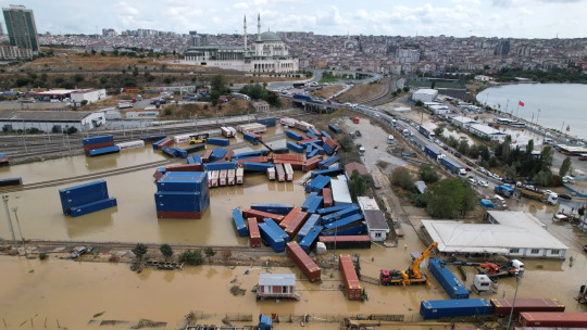
Istanbul, Turkey (CNN).
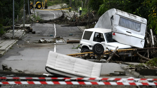
Tsarevo, Bulgaria (CNN).
Four people died in Bulgaria and seven in Turkey.
But like I told you the core of this was exactly on top of Greece's central mainland and islands. So what happened there? I happened to experience this shit first hand. My recollection of it is that it was unlike any other storm I had experienced before. My knowledge on meteorology is not very advanced, however I believe due to the high pressure part, there were actually no winds at all - or they were insignificant, so it wasn't like what you might have in mind as a conventional cyclone. It was a rainstorm but it was like a rainstorm from hell. The crucial part is that in Greece summer violent rainstorms may last for about five minutes but certainly not for five days nonstop. There was no pause, not even for a second. It kept pouring and pouring in indescribable volumes, without decreasing or slowing down, not for a moment. The fourth day it started taking short breaks.
As a person with a phobia of lightnings since childhood, I kept wearing earplugs throughout all these days. For four days, ten seconds did not pass without at least one lightning shrieking exactly on top of our heads. In the end, I am dead serious, I think my lifelong phobia has been cured somewhat due to this extreme exposure that eventually had a numbing effect. I think only the first day there was a record of 7,000 lightnings. I believe there must have been dozens of thousands overall. The lightnings also caused fires but the downpour was so overwhelming no fire could ever stand a chance.
Whether during or after the rains, what I was seeing outside was post-apocalyptic. The only thing missing was the zombies. It really looked like a background from a videogame, including a constantly lit up sky. I was not in danger though people dear to me were. The worst for me was a huge fall in the quality of living but that doesn't matter. The rains caused severe destructions across cities and villages. They caused floods, they broke bridges, they broke a massive number of roads, they made walls collapse, they destroyed springs, they damaged water and electricity outlets entirely, they drowned flocks and flocks of animals, they destroyed mountainous and coastal villages alike, they made cars float and fly over each other and they uprooted houses.

Village in Mount Pelion, Greece.
But that's not the end of it. Four days later, the storm moved southwest towards the Ionian sea, basically to the place of its original formation. It side-swept over Athens in the meantime, flooding the city, but that doesn't mean much since I could cry and Athens would still flood with my tears. Anyway. AFTER the storm left, the floods caused by it started multiplying and expanding. Picture that: a crystal clear sky, a bright sun and your phone screaming state alerts about evacuating your village or town because a lake has launched at you! Here's the thing: Thessaly is a massive plain surrounded by a ring of mountains. Half of those downpours fell right on the lowlands causing floods and destructions the first days. The other half however fell on the mountains, filled the streams heading down and they all met up and filled the lakes and the large river of Thessaly, Pineios and they all basically exploded the next days. Pineios especially exploded both in its western and eastern part, sinking the entirety of Thessaly's plains under water. As a result, floods were actively taking place days after the storm had ended and the weather was good. The phenomena have only started subduing since yesterday.

The overflowing of the river, trapped by the mountains.
Farmers won't be able to work this year and next year is questionable as well. There are huge concerns about various epidemics breaking out as more and more dead animals are found in the waters. Entire villages are under the water. There are estimations that some villages in west Thessaly might have been lost forever and their residents will have to move elsewhere. Sixteen people have died from the rainstorm and the floods.

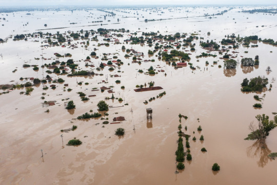
Actual villages in Karditsa, Greece.
A more longterm danger is that the ground received such an unnatural amount of water that it might have been severely eroded and destablised, making it vulnerable to natural disasters I don't want to utter. Many roads are either broken or bloated and Thessaly has been cut out from communication and transportation with the rest of the country. To this day, there are maps guiding people how to drive from North to South Greece and vice versa by entirely skipping Central Greece! (Hint: they will have to drive through Epirus, aka western Greece.) The first days there was also complete isolation from what was happening in the country and the world and also the very regions we were in as we had no electricity and our only chance was getting a call from somebody being elsewhere and telling us what is going on.

Volos, Greece (CNN)
Many regions have received within 2-4 days 55 times their monthly amount of rain or more than twice the yearly amount. Greek meteorologist Christos Zerefos estimated that such a phenomenon occurs every 300-400 years. Meteorologists were alarmed internationally - with Germans and Americans reportedly saying they hadn't studied such a phenomenon again in their career. Its intensity was record high in the history of Greece and right in the top of Europe's as well. They also agreed that such a phenomenon would be devastating even if it had hit the most advanced and prepared country.
BUT THIS IS NOT THE END. The weakened Daniel seemed to slowly move towards South Italy but it decided to take a turn and headed south towards Libya and Egypt. Quite possibly, as the storm was once again travelling across the warm Mediterranean Sea, it was rejuvenated and gained even more tropical traits. Eventually, the medicane hit Libya with unprecedented force.

The cyclone travelling from Greece to Libya.
The toll it took on Libya is unspeakable. As I am writing this,
More than 5,226 people are killed and more than 10,000 are currently missing.
Like, can you wrap your head around what I am talking about? I don't see this shit being acknowledged enough across the world. I am checking this again and again, to ensure I am reading this correctly.
Daniel has officially become the deadliest medicane on record.
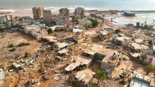
Eastern Libya, from Al Jazeera.
In the meantime, Greeks found opportunities to practice their favourite sport: political infighting. People who weren't even here when hell broke loose say that if this or that was properly done, we would not have problems at all. I even saw an idiotic Greek expat comment how "we got drowned in a little bit of rain". The truth is we should bloody thank our lucky stars and I say this with the entire awareness of half of Thessaly being currently underwater. It is true that Greek governments and people have done so many things badly, like building on top of streams and rivers, changing rivers' natural route, drying up natural lakes and all that shit that guarantees you are going to have massive problems once a serious storm breaks out. Also, the disaster revealed that there was once more a very questionable management of all the money given by the EU for anti-flooding measures after a previous flood (Ianos). Of course, I would be happy if at last we viewed this disaster as an opportunity to improve ourselves and the management of our land, however whatever happened these days wasn't the fault of anyone in particular. On the contrary, A LOT worse could have happened. A lot. Maybe Libya is not an indication because if Greece is not used to such extreme rain phenomena, then Libya is probably ten times less used to them, however we should not forget that this monster was STUCK at least five days over the heartland of Greece. For this alone we should damn be thankful we did not get it any worse and that the land endured in any way and of course now we have to correct old mistakes as well but let's do it united and determined and without wasting time once more in pointless infighting, which in this case might even be unfair. (In fact I think the thing we should blame the state the most about was not making it clear beforehand that this was going to be unprecedented, not just "very severe". They probably didn't want to cause panic and mayhem but still. We should know.) Of course I am not talking about how the state will treat the afflicted regions from now on, which is entirely its responsibility. And we should stand next to Libya. Greece has its wounds to mend but it should absolutely provide support to Libya. We know what this freak phenomenon was like.
I know this text is long but please consider reblogging this. We should know what happens on our planet. Thousands of people are dead from a freak phenomenon devastating regions across lands and seas. Also forgive any mistakes I might have made although I believe the information is correct for the most part. I didn't speak more about Libya because I don't know enough to analyze the situation as much. Perhaps there are ways of supporting the country too. As a last note, this phenomenon was not freakish because of the climate change - it was just a very unusual occurence. However, the - otherwise normal - warmth of the sea did feed and intensify the storm and the climate change might in the future cause these super rare, accidental phenomena to become more frequent.
#greece#libya#weather#climate change#storm#rainstorm#cyclone#flooding#natural disasters#world#tw death mention#world news#europe#africa#turkey#bulgaria#egypt#maps#storm daniel#greek facts#greek news#news#tw long text#tw long post#tw long#signal boost
790 notes
·
View notes
Text

59 notes
·
View notes
Text

Here's how climate change is redrawing Europe’s wine map !
'Ten years ago, you would never see a Danish wine on the list,' says Paul Robineau, executive head sommelier for the Taillevent group. 'But, with the climate changing, Denmark is on its way to make great wines.'
Courtesy: Financial Times
#human rights#humanity#equal rights#climate crisis#climate catastrophe#climate action#climate change#global warming#climate justice#environment#pollution#human footprint#rioja#wine#winelover#red wine#europe#map#winery#sustainableliving#sustainablefarming#sustainability#financial times#denmark#chardonnay
20 notes
·
View notes
Note
do we have any info about different climates and flora/fauna of different regions/continents? :0 for example what the main elven territories are like
There isn't anything about the climate as far as I remember
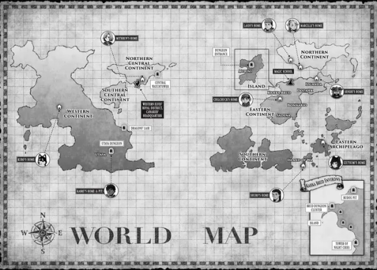
Most we have to speculate on is the world map, it has a lighter grey in the northern parts so I assume those are snowy/cold? For the northern and southern central continent we can only assume is not too cold due to elf fashion being very light for the most part. Kobolds are said to live in the desert on the western continent so I assume there is a hot and dry climate, since Utaya wasn't very far its probably not too different?
The rest idk
55 notes
·
View notes
Text
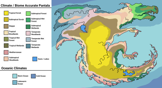
Okay, not AS good as the last one, but in order for this heckin continent to have the biomes it does, ONE: It's significantly smaller than Pyrrhia, and TWO: It would have to be near the equator.
#alo art#wings of fire#wof#wof headcanon#cartography#Pantala#climate map#headcanon#Just you wait till I suddenly feel like recreating Pyrrhia in my own image I really need a better hobby someone please save me#Take away my tablet
634 notes
·
View notes
Text
i love doing soul draining repetitive tasks for my assignments for hours and hours instead of having free time to enjoy being 20 years old <333
#bro we dont need to count and map out every fucking root of these massive plants#you're not going to solve climate change with your paper bcs people out there don't believe in it and they have like 10000 times more power#anyways being a biology student is just a highway to depression because you will learn#that you're most likely die from cancer in a 8am lecture and then immediately after that you'll go#and learn that you'll actually starve to death because of climate change instead#just positive vibes all around:)
23 notes
·
View notes
Text
"As countries around the world begin to either propose or enforce zero-deforestation regulations, companies are coming under growing pressure to prove that their products are free of deforestation. But this is often a far from straightforward process.
Take palm oil, for instance. Its journey from plantations, most likely in Indonesia or Malaysia, to store shelves in the form of shampoo, cookies or a plethora of other goods, is a long and convoluted one. In fact, the cooking oil or cosmetics we use might contain palm oil processed in several different mills, which in turn may have bought the raw palm fruit from several of the many thousands of plantations. For companies that use palm oil in their products, tracing and tracking its origins through these obscure supply chains is a tough task. Often it requires going all the way back to the plot level and checking for deforestation. However, these plots are scattered over vast areas across potentially millions of locations, with data being in various states of digitization and completeness...
Palmoil.io, a web-based monitoring platform that Bottrill launched, is attempting to help palm oil companies get around this hurdle. Its PlotCheck tool allows companies to upload plot boundaries and check for deforestation without any of the data being stored in their system. In the absence of an extensive global map of oil palm plots, the tool was developed to enable companies to prove compliance with regulations without having to publicly disclose detailed data on their plots. PlotCheck now spans 13 countries including Indonesia and Malaysia, and aims to include more in the coming months.
Palm oil production is a major driver of deforestation in Indonesia and Malaysia, although deforestation rates linked to it have declined in recent years. While efforts to trace illegally sourced palm oil have ramped up in recent years, tracing it back to the source continues to be a challenge owing to the complex supply chains involved.
Recent regulatory proposals have, however, made it imperative for companies to find a way to prove that their products are free of deforestation. Last June, the European Union passed legislation that prohibits companies from sourcing products, including palm oil, from land deforested after 2020. A similar law putting the onus on businesses to prove that their commodities weren’t produced on deforested land is also under discussion in the U.K. In the U.S., the U.S. Forest Bill aims to work toward a similar goal, while states like New York are also discussing legislation to discourage products produced on deforested land from being circulated in the markets there...
PlotCheck, which is now in its beta testing phase, allows users to input the plot data in the form of a shape file. Companies can get this data from palm oil producers. The plot data is then checked and analyzed with the aid of publicly available deforestation data, such as RADD (Radar for Detecting Deforestation) alerts that are based on data from the Sentinel-1 satellite network and from NASA’s Landsat satellites. The tool also uses data available on annual tree cover loss and greenhouse gas emission from plantations.
Following the analysis, the tool displays an interactive online map that indicates where deforestation has occurred within the plot boundaries. It also shows details on historical deforestation in the plot as well as data on nearby mills. If deforestation is detected, users have the option of requesting the team to cross-check the data and determine if it was indeed caused by oil palm cultivation, and not logging for artisanal mining or growing other crops. “You could then follow up with your supplier and say there is a potential red flag,” Bottrill said.
As he waits to receive feedback from users, Bottrill said he’s trying to determine how to better integrate PlotCheck into the workflow of companies that might use the tool. “How can we take this information, verify it quickly and turn it into a due diligence statement?” he said. “The output is going to be a statement, which companies can submit to authorities to prove that their shipment is deforestation-free.” ...
Will PlotCheck work seamlessly? That’s something Bottrill said he’s cautiously optimistic about. He said he’s aware of the potential challenges with regard to data security and privacy. However, he said, given how zero-deforestation legislation like that in the EU are unprecedented in their scope, companies will need to sit up and take action to monitor deforestation linked to their products.
“My perspective is we should use the great information produced by universities, research institutes, watchdog groups and other entities. Plus, open-source code allows us to do things quickly and pretty inexpensively,” he said. “So I am positive that it can be done.”"
-via Mongabay, January 26, 2024
--
Note: I know it's not "stop having palm oil plantations." (A plan I'm in support of...monocrop plantations are always bad, and if palm oil production continues, it would be much better to produce it using sustainable agroforestry techniques.)
However, this is seriously a potentially huge step/tool. Since the EU's deforestation regulations passed, along with other whole-supply-chain regulations, people have been really worried about how the heck we're going to enforce them. This is the sort of tool we need/need the industry to have to have a chance of genuinely making those regulations actually work. Which, if it does work, it could be huge.
It's also a great model for how to build supply chain monitoring for other supply chain regulations, like the EU's recent ban on companies destroying unsold clothes.
#deforestation#palm oil#indonesia#malaysia#agriculture#european union#united states#save the forest#open source#technology#mapping#forestry#satellite#good news#hope#climate solutions#environment
122 notes
·
View notes
Photo

Hot & Wet: 4 Basic Climates in the USA
1K notes
·
View notes
Text
Urban heat island mapping is revolutionizing how cities address extreme heat
Sign-up Your US City for a Neighborhood Heat Health Mapping Climate Study
NOAA seeks applications for 2024 urban heat island initiative
Communities must apply by January 31 for heat mapping program
Apply here:
I did this with my local community last year and wrote-up a blog about the experience focused on neighborhood heat health tips:
#heat#urban heat#map#climate#opportunity#program#apply#mapping#maps#climate heat#global warming#government program#climate mapping#climate map#climate justice#urban heat island effect#urban heat islands
2 notes
·
View notes