#Canadian Shield bedrock
Explore tagged Tumblr posts
Text

Big Sky
What do you think about my pic?
#Yellowknife#NWT#Northwest Territories#nature#travel#original photography#vacation#tourist attraction#landmark#landscape#Canada#summer 2024#cityscape#the North#photo of the day#What do you think about my pic?#rock#forest#Canadian Shield bedrock#Great Slave Lake
129 notes
·
View notes
Text
Geology and The Terror
As a geologist who is incapable of turning off their geology brain even while watching shows for fun, one of the things that baffles me a bit about The Terror is why they continuously refer to the landscape as shale when both King William Island and the filming location in Pag, Croatia are dominated by limestone. Given the desolation of the landscape, the geology is rather at the forefront of many scenes so it was fun to try and parse it out as I watched.
King William Island, Nunavut, Canada
According to the official map of the bedrock of the region as published by the Canadian government (Harrison et al., 2015), the entirety of King William Island is mapped as dolostone, dolomitic limestone, and limestone with only minor components of shale, sandstone, conglomerate, and breccia. This is a shelf marine deposit dating back to the Late Cambrian, so this is very old sedimentary rock but younger than most of the surrounding hard rock that composes various parts of the Canadian shield. Notably, the pink units mapped on the Boothia Peninsula are Paleoproterozoic in age (2.5-1.6 billion years old), potentially up to 2 billion years older than the limestones of King William Island.

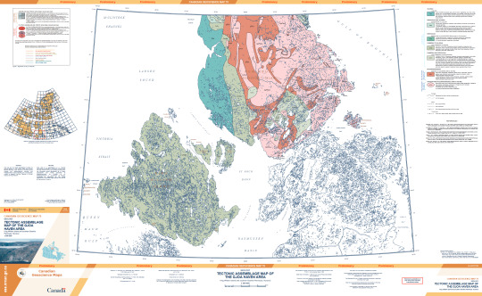
(This is an absolutely massive .pdf file with some scaled features so I would recommend viewing via the official publication to actually read anything or see fine details: publications.gc.ca/pub?id=9.557274&sl=0)
Notably, this map was published in 2015, 8 years after the novel was written. However, according to the bibliography for the map (which can be accessed via the previous link) a preliminary geologic map has existed for the area since at least 1967, though I was unable to track this publication down online. The novel was clearly thoroughly researched and Dan Simmons could have easily accessed this publication and others through multiple institutions.
The surficial geology of King William Island has also been mapped, and is predominantly glacial, as one would expect given it's location. For those unfamiliar with glacial geology processes, this is basically saying that the bedrock is buried under a bunch of glacial deposits. Glacial till is composed of rocks and sediments plucked from the bedrock and ground up. This is why the surface of the island is not one big rock, but a bunch of smaller pieces. Interestingly, the material on the southern part of the island is sandier because it contains more material derived from the Canadian Shield further south. If you're interested in glacial geology, I highly recommend zooming around a bit on Google Earth because the features here are GORGEOUS.
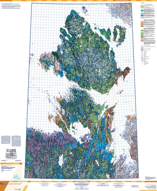
(This map is absolutely massive and the lines scale with zoom so it's hard to see at this resolution, access it here: publications.gc.ca/pub?id=9.834073&sl=0)
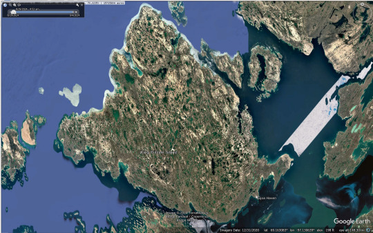
(Google Earth Pro, satellite imagery from 2020)
According to the surface geology map and Google Earth, the actual landscape of King William Island is much more water logged than it appears in the show. It's not entirely impossible that there has been some geomorphological change since 1848, but most of the features mapped would have been formed during the last ice age and as the glaciers melted and not more recently. This would have been handy for the men of the Franklin Expedition because each of these pools is filled with freshwater.
Pag, Croatia
Tracking down a geologic map of Croatia was somewhat challenging as I don't speak Croatian. I was able to find a map of the whole country, and while it's all in Croatian the symbol for the geologic time periods is universal so time periods can be correlated. This shows that the units that make up Pag are Cretaceous and Paleocene-Eocene in age.
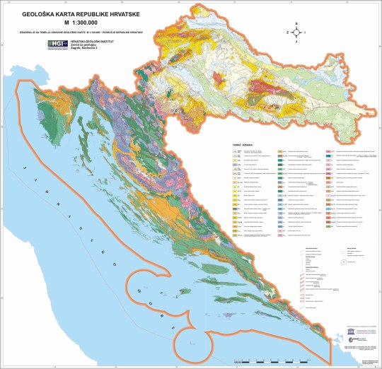
(Map accessed here: https://www.hgi-cgs.hr/en/geoloska-karta-republike-hrvatske-1300-000/)
I was able to find a .pdf (access here: http://kig.kartografija.hr/index.php/kig/article/view/158/274) that had a bit more information on the map above but at a lower resolution. This states that the Cretaceous units are dominantly carbonates from the Adriatic sea and the Eocene units are also carbonates. This makes sense as both the Cretaceous and Paleocene-Eocene boundary/PETM are times of increased global temperature correlated with increases in global sea level.
As always, the best geology website out there, Macrostrat, also came through on the unit lithologies. I was unable to access the source listed on Macrostrat, but both the Cretaceous (green) and Paleocene-Eocene units (orange) are listed as limestone.
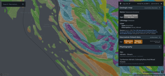
(Source: https://macrostrat.org/map/#x=16&y=23&z=2)
One of the best views that we get of the geology on Pag is the last scene with Bridgens in episode 9. During the zoom out of this scene we get a really nice view of the bedrock and debris covering it.
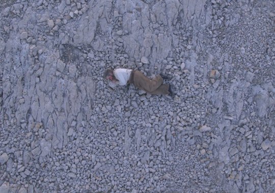
Given all of this, I'm really not sure where the landscape description as shale came from. If there is historical precedence for calling the rocks on the island shale, let me know! I have read a few books but none of the primary sources from the expeditions to this region, so if it comes from that I wouldn't be surprised.
Overall though, I have to say that the filming location was well chosen given the similarities it holds to the geology of King William Island.
#the terror#i have no idea whether this is of interest to anybody else#but i haven't been able to stop thinking about it since i started the show#because obviously the first thing i did was open up macrostrat to see what the geology was like#geology#peter posts#fr though the scene with bridgens is top tier in terms of getting a good view of the geology#it only took me three watches of the show to cave and make a post about it#franklin expedition
135 notes
·
View notes
Text
The Canadian Shield

Apparently, the Canadian Shield is a “geologic province”. That just means a large area with a lot of geology in common. I like it because it’s really WEIRD.
The Shield was created by glaciers sliding through. They scraped off all the topsoil and softer rock, and messed up all the watersheds. What developed in the ruins was a maze of endless rivers and lakes, large rocks covered in mosses and lichens, and trees. Lots of trees.¹

There are several things that I think are cool:
the rocks, moss, and lichen
the deranged drainage system
the endlessness
Rocks, Moss, and Lichen
Much of the Canadian Shield is covered in boreal forests (also called taiga). At least, wherever there’s enough dirt. But there is a LOT of exposed rock. And growing on those rocks are the coolest plants/animals in the world – lichens.
Lichens are a symbiosis of algae, fungi, and yeast! Some look like moss – all soft branched stalks. Some look like crunchy fungi or seaweed – growing off the rocks in weird ruffles. Others look like … paint? You know how some rocks will have coloured crusty spots that can be peeled off? Those are lichen! (Some are even powdery, but we don’t get many of those in the Shield.)

Then there’s ACTUAL moss. And moss is almost as cool as lichen! All wet and squishy and ridiculously complex if you look at it closely. Gorgeous stuff!
And finally, there’s the rocks themselves. If you live in an area with rocks, possibly you do not find them breathtaking. But I remember excitedly talking to my parents for SEVERAL MINUTES after seeing a rock in a field, because here in the prairies, you don’t see them.


And these are COOL rocks. Bedrock. Super hard igneous rock that doesn’t wear quickly. It forms cliffs and ravines, despite the fact that the area is quite flat on the macroscale. Canoeing under a cliff face that leans over you is an awe-inspiring experience. Staring down into the depths of the lake below you, seeing that it goes straight down, and then a few feet later the water is shallow. The rocks are big, and full of neat cracks, and pretty coloured, and … they’re good rocks.

Deranged Drainage System
Since the land is made of super hard rock that weathers slowly, and all the watersheds got messed up by the glaciers dumping rocks around the edges of the Shield, water struggles to form normal drainage systems. Rather than starting as small rivers and then combining as they flow downstream, water just collects in every lowpoint. Thousands of small lakes form, connecting to each other at odd, sometimes hidden, points, with very little predictability. Rapids and waterfalls are common. Shorelines are very irregular, with all sorts of hidden coves. It becomes difficult to figure out what is an island, and what is the mainland.

Looking down from the air, the landscape seems fractal. Sitting on a rock, staring at the opposite shore, it’s obvious that this is true.
Navigating these waterchannels takes a LOT of skill. Mapping them barely helps – the maps are complex enough that it’s hard to absorb the correct information. The Nîhithaw (Cree) navigate by attaching stories to the landmarks, which makes it fun to travel with a guide.

Endlessness
The Canadian Shield is HUGE. It covers over half of Canada! The features that make it up are small, and complex. Most of it is sparsely inhabited. There are few roads; and a lot of areas, travel is either by boat or float plane.
The effect is that of an endless landscape. By plane, you can see more lakes than you can count, all difficult to identify. They stretch to the horizon in every direction.
By boat, you can see many, many interesting and unique-seeming features. But half an hour later you’ll discover yourself in a spot that looks identical. You’re frequently slipping around blind corners and into narrow, hidden channels, which increases the sense of covering ground. But because you’re rarely going in a straight line, it’s difficult to figure out how far you’ve actually gone. It’s a maze, and it’s possible to travel it for days without seeing a single other human.

(Or you can see multiple groups of people over an hour long trip. It’s very unpredictable.)
That combination of isolation, scale, constantly changing view (that still stays the same TYPE of view), lets me truly FEEL the vastness. Everything about me gets quiet in the Shield. I’ll suddenly find my face aching from smiling so big for so long. The world is endless and peaceful and not designed for me in the slightest.
It’s exhilarating.
-
¹ There are a few different biomes in the Shield. But the main one, and the one I’ve mostly experienced, is the boreal forest. So that’s the part I’m focusing on. Especially the landscapes of the Whiteshell and northern Saskatchewan.
#geology#ecology#biomes#canada#canadian shield#Ha! Have no words today#but pretty landscape TRUMPS worldlessness!#the shield is my friend even though it doesn't even notice my existence
171 notes
·
View notes
Text
Charleston Lake
Charleston Lake is located in South Eastern Ontario, just north east of Gananoque. The lake is carved out of the Frontenac Axis, a relatively narrow extension of the Canadian Shield bedrock which dominates the landscape of Northern Ontario. The lake is the principal watershed for the Gananoque River, and boasts prime fishing locations. Charleston Lake Provincial Park is located on the shores of the lake, and offers camping, hiking, boating, fishing and interpretive sessions. Source: en.wikipedia.org/wiki/Charleston_Lake That was just the beginning of this Series on Charleston Lake so don't turn that Dial we are just getting started. On Charleston Lake there is a lot of Species Diversity, the following is just a few examples: Black Rat Snakes
Source: en.wikipedia.org/wiki/Pantherophis_obsoletus


Chipmunks (Eastern Chipmunks / Tamias striatus)
Source: en.wikipedia.org/wiki/Chipmunk

Squirrels
Source: en.wikipedia.org/wiki/Squirrel

Black Cats in the woods
Source: en.wikipedia.org/wiki/Black_cat

Leopard Frogs
Source: en.wikipedia.org/wiki/Leopard_frog

Fish:
Lake trout
Source: en.wikipedia.org/wiki/Lake_trout

Bass (Fish) (No Image Available)
(Fish Concluded)
Dragon Flies
Source: en.wikipedia.org/wiki/Dragonfly


Turtles
Source: en.wikipedia.org/wiki/Turtle


Crayfish
Source: en.wikipedia.org/wiki/Crayfish


Bees
Source: en.wikipedia.org/wiki/Bee

Seaweed
Source: en.wikipedia.org/wiki/Seaweed


Birch Trees
Source: en.wikipedia.org/wiki/Birch


Wasps
Source: en.wikipedia.org/wiki/Wasp

Eagles
Source: en.wikipedia.org/wiki/Eagle

Hummingbirds
Source: en.wikipedia.org/wiki/Hummingbird


Spiders
Source: en.wikipedia.org/wiki/Spider

Geese
Guess the Source: en.wikipedia.org/wiki/Goose

Ducks
Source: en.wikipedia.org/wiki/Duck

Swans
Source: en.wikipedia.org/wiki/Swan

These Species are key Parts of the Ecosystem and Biosphere at Charleston Lake. This Blog series will continue tomorrow when we cover Abiotic Components of the Biosphere & some concerns of the ecology of Charleston Lake.
2 notes
·
View notes
Text

The Many Arms of Réservoir Gouin
Like other parts of the Canadian Shield, water is omnipresent in the Mauricie region of Quebec. Numerous lakes, large and small, dot the surface—a byproduct of the glaciers that carved depressions into the region’s igneous bedrock during the most recent ice age.
However, people also played a role in shaping the region&rquo;s waterways when they created Réservoir Gouin, the sprawling many-armed lake shown in this satellite image. The scene was acquired by the OLI (Operational Land Imager) on Landsat 8 on October 17, 2023. Dark patches northwest of the reservoir are recent burned areas; brown and yellow areas to the east have been logged.
Construction of the Gouin dam began in 1916 to regulate the flow of the Saint-Maurice River and make it easier to float wood to pulp and paper mills downstream. After the concrete structure—measuring 26 meters (85 feet) high and 502 meters (1,647 feet) long—was finished, it transformed the network of lakes and river valleys upstream into what was then the world’s largest reservoir. It also meant that Obedjiwan (also spelled Opitciwan), an Atikamekw village on the north shore of the new reservoir, had to move to higher ground.
Before the dam’s construction, the flow of the Saint-Maurice River varied sharply from one season to the next. In 1913, for instance, it fluctuated between 170 cubic meters per second in the summer and 5,700 cubic meters per second during the spring flood, according to Hydro Québec.
The dam ultimately curtailed such swings, but the reservoir still sees seasonal variations. In winter, managers lower water levels to make room for spring snowmelt and summer rains, and they allow water levels to peak in the late summer or fall.
Such seasonal variations in the water level are observable from space. Gouin is among more than 300 lakes and reservoirs that NASA scientists monitor using data collected by radar altimeters on several satellites, including Jason-2, Jason-3, and Sentinel-6 Michael Freilich.
The project, based at NASA’s Goddard Space Flight Center, posts new water height measurements of the reservoir every two weeks. The reservoir’s water levels typically drop a few meters in the winter and have trended upward by a few meters overall since the 1990s, the satellite observations show.
NASA Earth Observatory image by Michala Garrison, using Landsat data from the U.S. Geological Survey. Story by Adam Voiland.
0 notes
Text
Top-Rated Parging Contractor in Toronto
The foundation of your Toronto home is its bedrock, literally and figuratively. It endures the brunt of harsh weather, shifting soil, and the weight of your entire structure. But protecting this crucial element often falls to a hidden layer – the parging.

Parging, sometimes referred to as stucco or veneer plaster, is a protective layer of mortar applied to the exterior foundation walls of your home. This thin coat serves a critical dual purpose:
Protection: It shields your foundation from water infiltration, preventing cracks, leaks, and potential structural damage.
Aesthetics: It creates a smooth, finished look that enhances your home's curb appeal.
When your parging shows signs of wear and tear, cracks, or water damage, it's time to find a top-rated parging contractor in Toronto. Here's what you need to know to make an informed decision.
Why Choose a Top-Rated Parging Contractor?
While parging might seem like a simple job, proper application requires expertise and experience. A qualified parging contractor will ensure the work is done correctly using the right materials and techniques. Here's why choosing a top-rated contractor is crucial:
Quality Workmanship: Experienced contractors know how to prepare the foundation surface, properly mix the parging material, and apply it correctly for optimal adhesion and longevity.
Durability: They understand the importance of using high-quality materials that can withstand Toronto's harsh climate.
Waterproofing Expertise: They know how to ensure a watertight seal between the parging and the foundation, preventing moisture infiltration.
Safety: Working with heights and heavy materials can be dangerous. Experienced contractors prioritize safety measures to protect themselves and your property.
Peace of Mind: Hiring a reputable contractor with a proven track record gives you peace of mind knowing the job will be done right.
Finding Top-Rated Parging Contractors in Toronto
With many parging contractors operating in Toronto, finding the right one can be overwhelming. Here's how to narrow down your search:
Online Reviews: Look for contractors with positive reviews on platforms like HomeStars, Google My Business, and social media. Read the reviews carefully to understand the contractor's strengths and weaknesses from past client experiences.
Industry Associations: Consider contractors who are members of reputable associations like the Canadian Home Builders' Association (CHBA) or the Masonry Contractors Association of Toronto (MCAT). Membership often indicates a commitment to quality standards and ethical practices.
Recommendations: Ask friends, neighbors, or your local building inspector for recommendations.
Get Quotes: Contact several shortlisted contractors to get free quotes. During the consultation, ask about their experience, the materials they use, their warranty policy, and their insurance coverage.
Taking Care of Your Parging
Once you have a top-rated parging contractor complete the job, there are steps you can take to extend the lifespan of your parging:
Regular Inspections: Visually inspect your parging for cracks or signs of water damage at least once a year.
Proper Drainage: Ensure proper drainage around your foundation to prevent water pooling.
Landscaping: Avoid planting trees or shrubs close to the foundation, as root growth can damage the parging.
Conclusion
Investing in a top-rated parging contractor in Toronto is an investment in your home's foundation and future. By taking the time to select a qualified professional, you can ensure your home is protected from the elements and maintain its structural integrity for years to come.
0 notes
Text
I grew up on well water also and it was AMAZING. It helps significantly that our well was 350 ft down through Canadian shield granite bedrock and tapped into an aquifer. If you turned on the cold tap it would quickly rival straight from the refrigerator level of cold. In the spring, when the sugar maples were running, it would taste sweet like maple syrup.
I grew up on a well. I didn’t really know how that made me different than other kids except that when their power went out they could still shower and flush the toilet and I couldn’t.
But the real difference is that well water often has little quirks. It’s fresh and yummy from a hole in the ground, it’s not fancy city water that goes through treatment. That means that it didn’t taste like it could be bottled up right from the tap.
In fact what it meant was it tasted like sulfur. Straight up rank eggs. We had it tested repeatedly and it was totally safe for everything, it just stank. It was just something I accepted without question. The sky was blue and water smelled like a chicken egg you'd missed because the hens had gotten sneaky and it had been slowly rotting in the hot summer sun day by day.
It wasn’t until I got older and had friends sleepover who expected a shower the next day that I really caught on that my water wasn’t what they were used to.
“What’s that smell?” they would ask in disgust.
I’d stick my head in the bathroom and look back at them in puzzlement. “What smell?”
I was completely immune. I’d drink it happily, it was as nothing to me to drink water that tasted like a demon had just pissed it out. My friends all thought I was completely off my rocker.
It wasn’t until years after I’d moved out that I smelled what everyone else did. I went to visit my parents to stay overnight. I turned on the shower and reared back. What was that smell?
City life had made me soft. I did not want a stinky egg shower anymore.
946 notes
·
View notes
Text
Post #4
Who are you to interpret nature through art? How do you interpret “the gift of beauty”?
Art is an effective way to capture and share a moment in time. Most people engage in this activity almost daily through the act of taking pictures with their phone. Subsequently, the possibility of sharing them through posting on social media widens the range this art can reach. Through my role as an interpreter, the creation and sharing of art, visual or otherwise, can foster a deeper connection with the subject of interpretation. Modern life moves at a pace much faster than we have ever previously lived. As such, some have observed a decline in imagination and compassion in the youth. This poses a challenge for interpreters as the position requests the imagination of its constituents to visualize how things may have looked in the past, as well as how the present might affect the future. Personally, I have little experience in creating any visual arts, however, I have always enjoyed experiencing it in galleries and museums. On the other hand, I have long enjoyed playing and writing music. I picked up the guitar at a young age and since then have learned to play the bass and drums as well. While I have never tried interpreting nature through music, I do not think it is outside of the realm of possibilities. In the early 20th century composer John Cage wrote some pieces inspired by his time identifying and foraging mushrooms. One of these pieces included a “silent symphony” which was meant to draw the audiences’ attention to minute noises that are often overshadowed by life’s daily cacophony. I believe a similar approach would be useful to draw people’s attention to the often overlooked, minute details in nature.
Using art to interpret nature is an astute mode of instilling desire to sense the beauty of our surroundings. I believe there is beauty in all landscapes if you know where and what to look at. Art, in any medium, can highlight these sources of beauty for an audience thus providing greater ability to see what beauty is already there. An example given in the unit module was the Group of Seven. A group of Canadian impressionist painters that captured the landscapes of Algonquin park. The windblown conifers and exposed bedrock of the Canadian shield invokes a sense of patriotism for the plethora of natural beauty held within our borders. By the time I had discovered the works of the group of seven I had already visited Algonquin, among other parks, a few times. However, the paintings still provided me with a refreshed outlook on these landscapes. Furthermore, the paintings encouraged me to continue camping in these parks with a newfound respect for the resources the hold. I believe these works would have had similar effects on Canadians since their creation. Additionally, the passion for nature cannot only be seen in the works of the artists but also their actions as Canadian citizens. Two of the groups’ members were even instrumental in the conception of Killarney Provincial Park. Art works in many ways to instill the gift of beauty. In doing so it provides space to realize natural beauty and encourage the preservation of its resources.
1 note
·
View note
Text
Click Here For Your Free Gold Investors Kit ✅:...
youtube
Click Here For Your Free Gold Investors Kit ✅: http://GoldInvestorsKit.com
Welcome to our comprehensive guide on Gold IRA rules, a crucial part of strategic retirement planning. This video is your roadmap to understanding the regulations and requirements of investing in a Gold IRA, providing you with a clear investment strategy to diversify your retirement portfolio and avoid costly mistakes.
We’ll delve into the specifics of IRS-approved gold, the bedrock of any Gold IRA. We’ll also guide you through the process of rolling over a 401k to a Gold IRA in this video here https://youtu.be/Yhernie9zCg, a vital strategy for those seeking to shield their retirement savings from inflation and economic uncertainty.
Grasping the rules around custodian requirements and secure storage options is key to avoiding penalties, and we’ll provide straightforward, concise explanations to help you navigate these aspects. We’ll also explore the tax implications and distribution rules that come with a Gold IRA account, ensuring you’re well-prepared to make informed decisions.
Whether you’re a seasoned investor or just embarking on your retirement savings journey, this video is designed to equip you with the knowledge and insights you need. So, join us as we unravel the rules of Gold IRA and pave the way to financial security.
Gold investing can be a powerful way to protect and diversify your portfolio, and a Gold IRA is one such avenue. However, it’s crucial to be aware of certain rules and regulations before opening one to avoid potential pitfalls.
Initially, a Gold IRA must be funded from a qualified retirement account such as a 401(k) or IRA. Once funds have been transferred, they can then be used to purchase gold coins or bullion.
Notably, Gold IRAs impose specific restrictions on the type of gold that can be included. Only coins and bars meeting IRS definition of pure gold may qualify to be held within an IRA - American Gold Eagles, Canadian Maple Leaves and Australian Kangaroos among them are among those eligible.
Gold IRA investments must also meet certain storage requirements; their gold must be stored at an approved depository that satisfies specific security and insurance standards.
Finally, it is essential that you collaborate with a reputable Gold IRA custodian who will guide you through the process and ensure compliance with IRS regulations.
By adhering to these rules, investors can enjoy all the benefits of gold investing while maximizing the tax savings of qualified retirement accounts.
Please share our video on What are the Rules of a Gold IRA https://youtu.be/JWuIXHF2_Hs
Stay connected with us for the latest insights on Gold IRA, retirement planning, and investment strategies.
Subscribe to our Youtube channel for comprehensive guides on Gold IRA rules, 401k to Gold IRA rollovers, and diversifying your retirement portfolio: https://www.youtube.com/@401krollovertogold/videos
Join our Facebook community where we discuss IRS-approved gold, custodian requirements, and secure storage options: https://www.facebook.com/401kgoldirarolloverguide/
Follow us on Twitter for quick updates on economic uncertainty, inflation protection, and financial security: https://twitter.com/CryptoCrispsBee
Connect with us on Linkedin for our latest post on maximizing your retirement savings with a Gold IRA rollover: https://www.linkedin.com/pulse/gold-ira-rollover-guide-maximizing-retirement-savings-rick-porter
And don’t forget to check out our latest articles on retirement savings plans and investment tips on our website: https://www.digitalprofilers.com/retirement-savings-plans/
For an even deeper dive into the world of Gold IRAs, don’t miss our comprehensive video guide on Vimeo. It’s packed with expert insights and tips to help you navigate your investment journey. Check it out here: https://vimeopro.com/cryptoeducation/gold-ira-guide/video/818533429
#GoldIRA, #RetirementPlanning, #goldirarollover
Craving More Knowledge? We’ve Got You Covered: Check Out DigitalProfilers’ Article ‘What are the Rules of a Gold IRA’ here: https://www.digitalprofilers.com/what-are-the-rules-for-a-gold-ira/
For those of you who are eager to expand your understanding of Precious Metals IRAs, we have two additional videos that you’ll find incredibly insightful.
Our first video, https://youtu.be/kXrhCATIycQ, provides a comprehensive look into the world of Precious Metals IRAs. It’s a must-watch for anyone considering this type of investment for their retirement planning.
The second video, https://youtu.be/shSQEiSGaBQ, offers valuable insights and tips on how to navigate the Precious Metals IRA landscape. It’s filled with expert advice to help you make informed decisions.
These videos are designed to arm you with the knowledge you need to effectively diversify your retirement portfolio and secure your financial future. Don’t miss out!
from Backlinks Jedi https://backlinksjedi.tumblr.com/post/719961467811741696
0 notes
Text

On a Walk
What do you think about my pic?
#Frame Lake Trail#Frame Lake#Yellowknife#NWT#Northwest Territories#nature#travel#original photography#vacation#tourist attraction#landmark#landscape#Canada#summer 2024#cityscape#architecture#the North#photo of the day#What do you think about my pic?#rock#forest#Canadian Shield bedrock
31 notes
·
View notes
Video
youtube
Click Here For Your Free Gold Investors Kit ✅: http://GoldInvestorsKit.com Welcome to our comprehensive guide on Gold IRA rules, a crucial part of strategic retirement planning. This video is your roadmap to understanding the regulations and requirements of investing in a Gold IRA, providing you with a clear investment strategy to diversify your retirement portfolio and avoid costly mistakes. We'll delve into the specifics of IRS-approved gold, the bedrock of any Gold IRA. We'll also guide you through the process of rolling over a 401k to a Gold IRA in this video here https://youtu.be/Yhernie9zCg, a vital strategy for those seeking to shield their retirement savings from inflation and economic uncertainty. Grasping the rules around custodian requirements and secure storage options is key to avoiding penalties, and we'll provide straightforward, concise explanations to help you navigate these aspects. We'll also explore the tax implications and distribution rules that come with a Gold IRA account, ensuring you're well-prepared to make informed decisions. Whether you're a seasoned investor or just embarking on your retirement savings journey, this video is designed to equip you with the knowledge and insights you need. So, join us as we unravel the rules of Gold IRA and pave the way to financial security. Gold investing can be a powerful way to protect and diversify your portfolio, and a Gold IRA is one such avenue. However, it's crucial to be aware of certain rules and regulations before opening one to avoid potential pitfalls. Initially, a Gold IRA must be funded from a qualified retirement account such as a 401(k) or IRA. Once funds have been transferred, they can then be used to purchase gold coins or bullion. Notably, Gold IRAs impose specific restrictions on the type of gold that can be included. Only coins and bars meeting IRS definition of pure gold may qualify to be held within an IRA - American Gold Eagles, Canadian Maple Leaves and Australian Kangaroos among them are among those eligible. Gold IRA investments must also meet certain storage requirements; their gold must be stored at an approved depository that satisfies specific security and insurance standards. Finally, it is essential that you collaborate with a reputable Gold IRA custodian who will guide you through the process and ensure compliance with IRS regulations. By adhering to these rules, investors can enjoy all the benefits of gold investing while maximizing the tax savings of qualified retirement accounts. Please share our video on What are the Rules of a Gold IRA https://youtu.be/JWuIXHF2_Hs Stay connected with us for the latest insights on Gold IRA, retirement planning, and investment strategies. Subscribe to our Youtube channel for comprehensive guides on Gold IRA rules, 401k to Gold IRA rollovers, and diversifying your retirement portfolio: https://www.youtube.com/@401krollovertogold/videos Join our Facebook community where we discuss IRS-approved gold, custodian requirements, and secure storage options: https://www.facebook.com/401kgoldirarolloverguide/ Follow us on Twitter for quick updates on economic uncertainty, inflation protection, and financial security: https://twitter.com/CryptoCrispsBee Connect with us on Linkedin for our latest post on maximizing your retirement savings with a Gold IRA rollover: https://www.linkedin.com/pulse/gold-ira-rollover-guide-maximizing-retirement-savings-rick-porter And don't forget to check out our latest articles on retirement savings plans and investment tips on our website: https://www.digitalprofilers.com/retirement-savings-plans/ For an even deeper dive into the world of Gold IRAs, don't miss our comprehensive video guide on Vimeo. It's packed with expert insights and tips to help you navigate your investment journey. Check it out here: https://vimeopro.com/cryptoeducation/gold-ira-guide/video/818533429 #GoldIRA, #RetirementPlanning, #goldirarollover Craving More Knowledge? We've Got You Covered: Check Out DigitalProfilers' Article 'What are the Rules of a Gold IRA' here: https://www.digitalprofilers.com/what-are-the-rules-for-a-gold-ira/ For those of you who are eager to expand your understanding of Precious Metals IRAs, we have two additional videos that you'll find incredibly insightful. Our first video, https://youtu.be/kXrhCATIycQ, provides a comprehensive look into the world of Precious Metals IRAs. It's a must-watch for anyone considering this type of investment for their retirement planning. The second video, https://youtu.be/shSQEiSGaBQ, offers valuable insights and tips on how to navigate the Precious Metals IRA landscape. It's filled with expert advice to help you make informed decisions. These videos are designed to arm you with the knowledge you need to effectively diversify your retirement portfolio and secure your financial future. Don't miss out!
0 notes
Photo

The granite bedrock of the Canadian Shield in Sylvia Grinnell Territorial Park, Iqaluit, Nunavut, Canada, was scraped clean by glaciers some 7,000 years ago.
11 notes
·
View notes
Note
Basic question. I wanna know what’s your favorite place in the world and why.
ohhhh I’m so bad at picking favourites. simple question, complicated answer. but
there’s this geographical region called the Canadian Shield. according to britannica.com, it’s shaped like this:

and is “the largest mass of exposed Precambrian rock on the face of Earth” (source).
basically: it’s bedrock, breaching the surface of the earth like a pod of enormous whales. millennia ago, in some places at least, it used to be mountains; now, they’re worn down, most of their tops eroded away. what’s left is these massive swells of bedrock that break through the dirt, and I can’t quite explain what I love so much about it but there’s something so poetic about it. it feels old, when you stand on it, and massive. it absolutely dwarfs you.
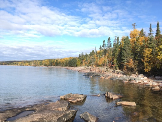
I’m not sure I can explain it any better, so here’s a photo I took on the northern shores of Lake Superior early this fall. I love this land with all my heart.
#thank you for the lovely ask!#I love canada on a geographical level#political... ehhh we’ve got work to do#but I love the land I live in. so damn much#quoth nsd#asked and answered#canadian shield#canadian geography#canada#geography
9 notes
·
View notes
Audio
Item #: SCP-037
Object Class: Euclid
Special Containment Procedure: SCP-037 is magnetically contained at Site-32. It is housed in a small subterranean room composed of a heat conducting, radiation-resistant polymer and evacuated of any atmosphere. Heat from the object is radiated into the surrounding rock. Should the integrity of the enclosure become compromised, the emergency system will generate a low power argon plasma shield until it is repaired. In the contingency of a [ACCESS DENIED].
Description: The artifact was discovered in 19██ above the Beaufort Sea at approximately the North Magnetic Pole. Intense electromagnetic interference was reported by Canadian Forces Station (CFS) Alert, followed by an extremely bright object descending toward the ocean from the sky. The SCPS Guardianresponded and discovered the object wavering in an erratic trajectory about 200 m above the surface of the water. Once containment procedures were devised it was transported to Site-32 for study.
SCP-037 is apparently a star approximately 5 cm (2 in) in diameter, with a luminosity of about 1*10-12 times that of our sun and a surface temperature of about 5000 K (determined by UBVRI analysis). The age and origin of SCP-037 is unknown, however, its nuclear activity is being carefully monitored for irregularities. Spectral analysis and comparison to known celestial bodies suggest that it is (other than its uncharacteristic size) a typical star quickly undergoing the transition to a red giant, though it is unknown if established theories of star formation and aging apply. It is thought to have entered the Earth's magnetosphere via the North Magnetic Pole.
Containment and transport of SCP-037 have been achieved by the use of powerful electromagnets, to which the artifact aligns itself according to its own magnetic field. The primary challenge to containment thus far has been its powerful electromagnetic emissions, which are intense enough to be easily seen by the naked eye from high Earth orbit. Its current enclosure is located deep underground to prevent detection and to facilitate radiative cooling into the surrounding bedrock. In effect, the entire facility and the surrounding volume of the Earth's crust act as a massive heat sink.
Over ██ years of study, the star has undergone a shift in emitted EM radiation, suggesting that it is undergoing stellar evolution at a vastly accelerated rate. If standard stellar models hold up, this will soon result in an increase in radius by a factor of 100 to 300 times, and a concomitant increase in radiated energy. Emergency containment contingencies are being studied for that eventuality. Further progression of the star's life cycle will likely terminate in a stellar nova, which is estimated to have a yield of ███████████. Extrapolations predict this to occur in ███████████. Research is underway for a method to arrest this development or to transport SCP-037 a safe distance from the planet before it occurs.
===
[Enjoy the podcast? Want access to exclusive bonus content? Consider supporting us on Patreon.]
#phinnsy#scp foundation#reading#voiceover#storytelling#podcast#sci-fi#horror#urban legend#folklore#fiction#astronomy#stars#scp 037
3 notes
·
View notes
Photo
If y'all think the Appalachian mountains are hot shit, you might be interested in the Canadian Shield, which is the oldest surface land on the planet. The youngest parts of the Canadiam shield are 2.5 billion years old, while the oldest land is 4.2 billion. They're really fucking old. Which means their mountains are even less impressive but shhh dont worry about it we love them anyways. Also, the shield has a pretty thin layer of dirt, beneath which is just rock. And by rock, I mean the bedrock which is the core of the entire continent of North America. The whole region is fascinating.
There's a reason I'll be dragging my ass 2000 km back to Thunder Bay to attend university, and that reason is so I can study geology right on the Canadian shield.
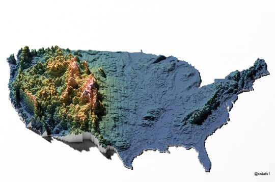
US Elevation.
by @cstats1
#the canadian shield is fucking baller#grew up on it and miss that shit every day#also the region is covered in lakes. so much good fishing out there
321K notes
·
View notes
Text

Canadian Conservative leader, Pierre Poilievre, wants to defund the CBC. A surprising new labelling policy at Elon Musk's Twitter gave him the chance to raise the profile of that agenda
https://nationalpost.com/opinion/i-run-cbc-news-elon-musks-twitter-changes-had-to-be-called-out
#Twitter#free speech#spin#labels#press#funding#shadow bans#Elon Musk#birdwatching#CBC#Conservatives#Pierre Poilievre#Canada#news#via Politicoast#National Post#world news
0 notes