#Amargosa Range
Explore tagged Tumblr posts
Visit Tumblr Blog
Explore Tumblr blogs with no restrictions, modern design and the best experience.
Last Seen Tumblr Blogs


Fun Fact
69% of Tumblr users are millennials.
Video

flickr
Sometimes You’re Sitting in a Parked Car and See Amazing Colors and Patterns on a Mountainside (Death Valley National Park) by Mark Stevens Via Flickr: While at the Death Valley Pay Station with a view looking to the southwest to a mountainside of the Amargosa Range. This is in Death Valley National Park. What I was attempting to do in capturing this image was finding a balance between the colors with the patterns and shapes on this mountainside and that of the skies above as a color contrast.
#Amargosa Range#Azimuth 254#Borax Mine#Color Efex Pro#Day 5#Death Valley#Death Valley National Park#Death Valley Pay Station#Desert Landscape#Desert Mountain Landscape#Desert Plant Life#DxO PhotoLab 6 Edited#Great Basin Ranges#HDR#HDR Efex Pro 2#Intermountain West#Joshua Tree National Park and California#Landscape#Landscape - Scenery#Looking SW#Mojave Desert#Mountain Peak#Mountains#Mountains in Distance#Mountains off in Distance#Mountainside#Nature#Nikon D850#No People#Outside
5 notes
·
View notes
Text

VOLE is just LOVE rearranged.
Amargosa Vole (Microtus californicus scirpensis)
Small range around the Amargosa river
Status: Endangered
17 notes
·
View notes
Text
Ash Meadows Amargosa pupfish males (blue) competing for a female’s (gray/green) attention
these fish are related to the more famous devils hole pupfish, and both are found within the bounds of death valley national park. this fish is critically imperiled, with a small endemic range.
#fish#ecology#fishblr#nature#death valley#honestly I just think they’re cute. and this area of the park was beautiful
186 notes
·
View notes
Photo

Lawsuit Aims to Help Amargosa Voles
The Center just sued the Bureau of Land Management to protect highly imperiled Amargosa voles from unmanaged human activity in their protected critical habitat. Off-road vehicles, unattended campfires, and people using the marshy lands for toilet functions have severely degraded the mouselike animals’ tiny remaining range — near a popular hot spring outside Tecopa, California.
#center for biological diversity#photographer#amargosa voles#voles#mammal#animal#california#tecopa#nature#wildlife
25 notes
·
View notes
Text

Zabriskie Point, part of the Amargosa Range located east of Death Valley in Death Valley National Park, California
2 notes
·
View notes
Text

Zabriskie Point, part of the Amargosa Range located east of Death Valley in Death Valley National Park, California [Photo credit: Johannes Plenio]
3 notes
·
View notes
Text
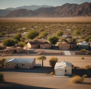
Amargosa Valley NV Properties
Amargosa Valley NV properties is a small town located in Nye County, Nevada, about 100 miles northwest of Las Vegas. The area is known for its natural beauty, with the Amargosa Desert and the Amargosa River running through the area, and for its proximity to the Ash Meadows National Wildlife Refuge and the Death Valley National Park.
Rural NV Properties
Amargosa Valley NV Properties offers a diverse range of homes and properties to cater to various needs and preferences. Whether you're looking for a cozy single-family home or a spacious estate, the options available in Amargosa Valley NV Properties are sure to meet your requirements. With a buyer-friendly housing market and a favorable climate, Amargosa Valley presents an enticing opportunity for real estate investment. We will explore the different property types, delve into the housing market trends, highlight the amenities and facilities, and identify the best neighborhoods in Amargosa Valley. We will provide valuable tips for buying property in this promising region. Let's dive into the world of Amargosa Valley NV Properties and discover the exciting possibilities that await.
Available Property Types
The diverse range of available property types in Amargosa Valley, NV caters to a variety of preferences and budgets, offering options such as single-family homes, condos/townhomes, luxury apartments, and large acreage properties. These properties provide ample opportunities for individuals and families looking to invest in the Amargosa Valley NV Properties real estate market. Whether someone is looking for a cozy single-family home, a stylish condo or townhome, a luxurious apartment, or a sprawling acreage property, there is something to suit every taste and budget. The real estate listings held by the site owner are marked with detailed descriptions and specifications, making it easy for potential buyers to find the perfect housing option in Amargosa Valley, NV. With a wide range of property types available, Amargosa Valley offers something for everyone in the housing market.
Housing Market Trends
The Amargosa Valley NV properties housing market in NV exhibits noteworthy trends that reflect the current state of real estate in the area. According to data from the Greater Las Vegas Association of Realtors' Internet Data Exchange Program, the median listing home price in Amargosa Valley, NV is $48,000. Houses for sale in the area typically spend an average of 194 days on the market, indicating a slower-paced market.
Amenities and Facilities
Amargosa Valley NV properties offers a wide range of amenities and facilities to cater to the diverse needs of its residents and visitors. In terms of real estate, Amargosa Valley NV Properties provides various options for renting, including apartments, luxury apartments, and townhomes. The area boasts real estate listings with large acreage, ranging from 9.53 acres to 320 acres, offering different preferences to potential buyers. Access to social media platforms allows users to connect with listing brokers and stay updated on available properties. Home sizes in Amargosa Valley vary significantly, from a modest 728 sqft to expansive properties spanning 268.13 acres. With decreasing home prices and a slowdown in market activity, now is an opportune time to explore the amenities and facilities that Amargosa Valley NV Properties has to offer.
Tips for Buying Property in Amargosa Valley
When considering a property purchase in Amargosa Valley, there are several key tips to keep in mind. It is important to do thorough research on the real estate market in the area. This includes understanding the current trends, prices, and availability of houses in Amargosa Valley NV Properties. It is advisable to work with reputable brokerage firms that specialize in the area. These firms have extensive knowledge and experience in the local market and can provide valuable insights and guidance throughout the buying process. Potential buyers should carefully consider their budget and financing options to ensure a smooth transaction. Visiting the property in person and conducting inspections is crucial to ensure that the house in Amargosa Valley meets all requirements and is in good condition.
Frequently Asked Questions
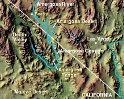
What Is Amargosa Valley Known For? Amargosa Valley NV properties is known for its diverse range of homes and properties, favorable housing market for buyers, and inviting climate with pleasant temperatures throughout the year. It offers something for everyone, making it an attractive destination for residents and tourists. What is the source of the Amargosa River? The Amargosa River proudly claims two sources, depending on who you ask – a surface water one and a hidden, subterranean one. On the surface: The Amargosa's story begins near Beatty, Nevada, at the southern foot of Pahute Mesa. Here, at an elevation of around 3,900 feet, Thirsty Canyon Wash dumps its precious cargo into the thirsty earth, marking the official start of the river's visible journey. From there, it flows southwestward into Oasis Valley, painting streaks of life across the parched desert landscape.
Opens in a new window

fr.wikipedia.org Amargosa River source, Pahute Mesa, Nevada Below the surface: But the Amargosa's tale goes deeper. Its true source lies in a vast underground reservoir known as the Carbonate Aquifer. This hidden treasure trove of water stretches across the Mojave Desert, fed by a complex network of springs and seeps. The Amargosa River taps into this aquifer at various points along its course, replenishing its surface flow and sustaining the fragile desert ecosystem. So, there you have it! The Amargosa River, a desert lifeline, draws its lifeblood from both the visible and the unseen, a testament to the intricate dance of water in this arid land. What is the elevation of Amargosa Valley? Amargosa Valley sits at an elevation of 2,664 feet (805 meters) above sea level. This places it in the lower to moderate range of elevations typically seen in the Mojave Desert, contributing to its characteristic landscape of flat, sandy expanses interrupted by rocky mounds and hills. What county is Amargosa Valley in? Amargosa Valley is located in Nye County, Nevada, although the Amargosa River itself straddles the border between Nevada and California. The vast majority of the valley, including the unincorporated town of Amargosa Valley, falls within Nye County's jurisdiction.
Amargosa Valley NV Properties
The area is relatively rural and is primarily used for farming and ranching.
As for land and properties, there is a variety of options available in Amargosa Valley, including residential properties, commercial properties, and large plots of land that are ideal for farming or ranching. Prices for land and properties in the area vary depending on the size and location of the property, with some properties costing as low as $50,000 and others going as high as several hundred thousand dollars. It is worth noting that this area is still relatively rural and many properties are not connected to city services such as water, sewage and electricity, so buyers should be prepared to install their own septic systems and wells if they choose to purchase a property in the area.
Nye County NV Properties
There are several reasons why someone might consider purchasing land or property in Amargosa Valley NV properties, Nevada: - Scenic beauty: The Amargosa Valley is known for its natural beauty, with the Amargosa Desert and the Amargosa River running through the area, and for its proximity to the Ash Meadows National Wildlife Refuge and the Death Valley National Park. - Outdoor activities: The area offers a wide range of outdoor activities, such as hiking, camping, fishing, and hunting, making it a great place for outdoor enthusiasts. - Privacy: The area is relatively rural, and many properties are located on large plots of land, providing a sense of privacy and seclusion. - Investment potential: The area is growing in popularity, and as more people discover the beauty and potential of the area, the value of land and properties is likely to increase. - Self-sufficiency: Many people who purchase land in the area are interested in living a more self-sufficient lifestyle, growing their own food, and raising animals. - Affordable: compared to other locations in the state or nearby cities like Las Vegas, the land and properties in Amargosa Valley are relatively affordable. - Natural Resources: The area offers natural resources such as water and minerals, which can be beneficial to those who plan to establish a business or use the land for farming or ranching. Keep in mind that this area is relatively remote and can be isolated in terms of services and access to amenities, so it's important to research the area and make sure it fits your needs before making a purchase. Amargosa Valley NV properties are active in both Clark County and Nye County, Lincoln County. The Amargosa Valley near Pahrump and Death Valley and about 2 hours from Las Vegas. Rural areas real estate services including Amargosa Valley, Beatty, Indian Springs, Las Vegas, Pahrump, Sandy Valley, Searchlight, Alamo, Moapa. Research homes, lots and land for sale in Amargosa Valley, NV including acres of undeveloped land, small residential lots, farm land, commercial lots, and large rural located in 89020 zip code. Amargosa Valley NV Properties Amargosa Valley NV properties offers a diverse range of homes and properties that cater to various needs and preferences. The buyer-friendly housing market in Amargosa Valley presents a promising opportunity for real estate investment. The region's pleasant year-round climate further adds to its appeal for residents and tourists. With a variety of property types available and a range of amenities and facilities, individuals with different requirements can find a suitable option in Amargosa Valley. Top Realtor! When buying Las Vegas homes for sale. Amargosa Valley NV Properties Read the full article
0 notes
Text
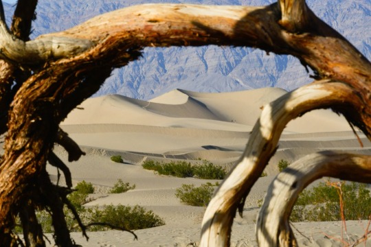
Hikers are seen in the distance at the Mesquite Sand Dunes in Death Valley National Park, California. This rugged desert landscape holds the world's record for the hottest air temperature—134°F in 1913. Tourists still flock here to experience the blistering heat. Photograph By Raul Touzon, National Geographic Image Collection
How Did Death Valley 🏜️ Gets Its Name? Not From The Heat
In December 1849, a group of settlers seeking their fortunes stumbled upon this inhospitable valley. The few who made it out alive assigned the haunting moniker.
— By Erin Blakemore | July 25, 2023
As a heat wave continues to blanket the Northern Hemisphere, tourists are making pilgrimages to the hottest place on Earth—Death Valley, California—in hope of experiencing a new world-record high temperature. The valley already holds the record for hottest air temperature ever recorded, a whopping 134°F in 1913.
But if they think the valley was named after its scorching summer temps, they’re wrong—it actually got its name from a winter disaster. Here’s how Death Valley got its name, and why it continues to lure visitors with its extreme weather and barren landscape.
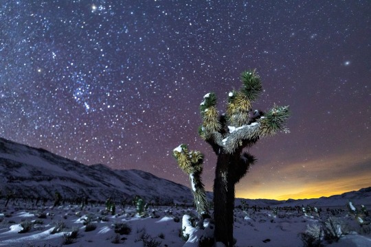
Photographing Death Valley’s starry skies shines a light on pollution. A national park artist-in-residence captures the fragility and beauty of the desert at night. August 20, 2020! As an artist-in-residence at Death Valley National Park, photographer Harun Mehmedinović captured images of its night skies and increasing light pollution. In this snowy shot, he caught both stars and, on the right, the glow of the city of Las Vegas. Photograph By Harun Mehmedinović
Inside A Desolate Desert
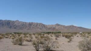
Located in southeastern California near the Nevada border, Death Valley is nestled in the northern Mojave Desert between four mountain ranges: the Panamint Range to the west, the Amargosa Range to the east, the Grapevine Mountains to the north, and the Owlshead Mountains to the south.
The area’s original inhabitants, the Timbisha Shoshone, lived in harmony with the valley for millennia. But when European settlers encountered it during their westward migration, they were flummoxed by the landscape. Though surrounded by mountain ranges, the valley is situated at the lowest elevation in the United States. The alkaline desert floor is bone dry and lacks vegetation, while the surrounding mountains trap the heat reflected by the sparse desert floor—making it blindingly hot in the summer and inhospitable even in winter.
Even before gold was discovered there in 1849, California attracted white settlers searching for a new life filled with natural riches. Many of these emigrants were completely unprepared for the arduous trip across both mountain and desert—and some fell victim to people who falsely claimed they knew the safest, fastest routes.
In one particularly famous case in 1846, a group of pioneers known as the Donner Party became snowbound after following the shortcut that a booster named Lansford Hastings had advertised. Stuck in the Sierra Nevadas, some of these pioneers eventually resorted to cannibalism and lost nearly half of their group to starvation and exposure.
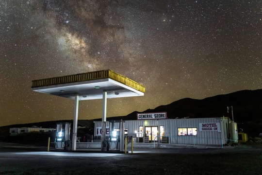
Photographing Death Valley’s starry skies shines a light on pollution. A national park artist-in-residence captures the fragility and beauty of the desert at night. August 20, 2020! The Milky Way looks brighter above Death Valley’s Panamint Springs thanks to the dim lighting at this gas station. Mehmedinović says the image shows the benefit of cutting out excessive light around national parks. Photograph By Harun Mehmedinović
On The Trail To Death Valley
Despite the Donner Party disaster—and the fact that they lacked familiarity with the terrain—boosters and wagon train leaders still attempted to find shortcuts on their journeys to California, especially after gold was discovered there.
In October 1849, members of trail leader Jefferson Hunt’s Mojave San Joaquin Company wagon train grew impatient with Hunt’s pace and his preferred route, known as the Old Spanish Trail. Some worried they’d be stuck in the mountains during the winter like the Donner Party if they didn’t move more quickly. They briefly convinced Hunt to try an alternative route, but Hunt returned from a reconnaissance mission nearly dead of thirst and told them he’d keep to the Old Spanish Trail.
A subset of the party still thought they could find a path west across the Mojave Desert, however—and when they met up with another, smaller party on the trail, they were shown a hand-drawn map of a cutoff that was endorsed, they were told, by some of the region’s most experienced trappers and mountaineers. After Hunt refused to take the shortcut, which would shave 500 miles and potentially months off the journey, much of the party broke off to try out the supposedly superior route.
At first, it seemed like they’d made the right choice: travel was easy, and they made good time. But soon they encountered more and more inhospitable terrain, and increasing disputes about how to proceed. One group headed toward a nearby mountain in hopes of finding water. The other, a group of younger, unmarried men who called themselves “Jayhawkers,” broke off into their own party and attempted to press due west to find the mountaineers’ advertised trail—a route that, it turns out, didn’t really exist.
As both groups journeyed, water became harder to find, and many turned back in search of Hunt rather than face the coming winter in the deadly Sierras. “Grass there is scarce, wood there is none,” wrote Jayhawker Sheldon Young of the landscape. “It is a dubious looking country.”
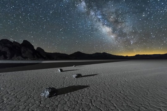
Photographing Death Valley’s starry skies shines a light on pollution. A national park artist-in-residence captures the fragility and beauty of the desert at night. August 20, 2020! Light pollution from cities can encroach on rural areas. Here, in Mehmedinović’s photograph of Death Valley’s Racetrack Playa, the glow on the right comes from Las Vegas, more than 200 miles away. Photograph By Harun Mehmedinović
Disaster Strikes
Weak and exhausted, in December 1849 both groups eventually entered a massive valley filled with salt flats and surrounded by mountains on all sides. Water was scarce in the desert valley; they were only able to locate highly alkaline water sources.
The Jayhawkers slaughtered many of their own oxen to eat and walked across the valley, eventually finding a Native American who guided them to safety. The other party tried going the other direction. As they pressed onward, this time another group of men decided to strike out on their own, and would ultimately die of exposure along their preferred trail.
On the verge of dehydration, the remaining members of the original party were briefly saved by a snowstorm. But over time, oxen dropped dead from thirst and exhaustion, and several men died. Finally, all but a few of the men broke off find their way over the mountains. The others waited patiently at the bottom of the valley.
Finally, after more than a month, the remaining party members—mostly women and young children—were rescued by two young men they’d sent off to get supplies. As they made their final crossing of the Panamint Mountains, one of the party members is said to have turned toward the valley and said “Goodbye, Death Valley.” Overall, it took the shortcut seekers more than four months to find their way to the part of California they sought.
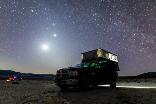
Photographing Death Valley’s starry skies shines a light on pollution. A national park artist-in-residence captures the fragility and beauty of the desert at night. August 20, 2020! "These images are meant to evoke a sense of wonder and curiosity,” says Mehmedinović. “I see images as a gateway to a discussion on the importance of the night sky and our impact on the environment.” Photograph By Harun Mehmedinović
The Highest Temperature Recorded on Earth?
The name stuck—and today, the valley is still known as one of the most barren and dangerous places in the United States. In 1913, the ambient air temperature reportedly rose to 134 degrees, still the world-record high air temperature.
Modern-day meteorologists dispute this reading, pointing out that the temperature was not in line with that of other nearby places and that even freak “hot spots” in the valley cannot account for those variations.
“It is possible to demonstrate that a temperature of 134°F in Death Valley on July 10, 1913, was essentially not possible from a meteorological perspective,” wrote meteorologist Christopher C. Burt in a 2016 analysis. However, the World Meteorological Organization, which validates world-record temperatures, still considers the reading a world record.
The group “is always willing to investigate any past extreme record when new credible evidence is presented,” the WMO wrote in a 2020 release, but to date the analysis has never been officially invalidated.
In the meantime, as a potential new extreme approaches, the organization says it’s ready to examine and validate any new records. Death Valley may not have gotten its name from a scorching summer’s day. But 174 years after it was named, the barren, salty valley is still as inhospitable as it was in 1849.
#Death Valley 🏜️#Inhospitable#California#High Temperature World Record#Desolate Desert 🐪#Mojave Desert#Timbisha Shoshone#European Settlers#United States 🇺🇸#The Alkaline Desert 🌵#Donner Party#Sierra Nevadas#Cannibalism#Jefferson Hunt#Mojave San Joaquin#Jayhawkers#Deadly Sierras#Panamint Mountains ⛰️#Meteorologist Christopher C. Burt#World Meteorological Organization (WMO)
0 notes
Text
A Step-by-Step Guide to Taking the Ultimate Death Valley Tour From Las Vegas
Overview of Death Valley and Its Incredible Natural Wonders
Death Valley is a vast, arid region located in eastern California, in the United States. The valley stretches over 3,000 square miles and is the lowest, driest, and hottest area in North America. Despite its harsh environment, Death Valley is home to many unique and incredible natural wonders.
One of the most striking features of Death Valley is its landscape. The valley is surrounded by towering mountains, including the Panamint Range to the west and the Black Mountains to the east. The valley floor is a vast expanse of salt flats, sand dunes, and rocky canyons, which provide a unique and otherworldly landscape to explore.
Death Valley is also home to several natural wonders, including:
Badwater Basin: This is the lowest point in North America, with an elevation of 282 feet below sea level. The basin is a vast expanse of salt flats that are beautiful to explore.
Mesquite Flat Sand Dunes: These are some of the most beautiful sand dunes in the park, and they offer a great opportunity for hiking and photography.
Zabriskie Point: This is a popular viewpoint that offers stunning panoramic views of the surrounding landscapes, including the badlands and the Amargosa Range.
Artist's Drive and Palette: This is a scenic one-way drive that offers breathtaking views of the colorful rock formations, including the famous Artist's Palette.
Scotty's Castle: This is a historic mansion that was built in the 1920s and offers a glimpse into the park's history and architecture.
Dante's View: This is a viewpoint that offers stunning panoramic views of the valley and the surrounding mountains, and it's a great place to watch the sunrise or sunset.
Ubehebe Crater: This is a volcanic crater that offers a unique and otherworldly landscape to explore.
Overall, Death Valley National Park is a unique and incredible natural wonder, offering a glimpse into the harsh beauty of the desert landscape. Visitors can explore the park's stunning landscapes, natural wonders, and rich history, making it an unforgettable destination for adventure seekers and nature lovers alike.
Preparing for the Ultimate Tour of Death Valley - What You Need to Know
If you're planning a tour of Death Valley, here are some things you need to know to prepare for an ultimate experience:
Plan your visit: Death Valley is a vast park, and it's important to plan your visit to make the most of your time. Consider which attractions you want to see, and plan your itinerary accordingly.
Dress appropriately: The weather in Death Valley can be extreme, with hot days and cool nights. Dress in layers, and wear comfortable clothing and shoes suitable for hiking.
Bring plenty of water: Dehydration is a real danger in Death Valley, so bring plenty of water, and drink it regularly to stay hydrated.
Watch out for wildlife: Death Valley is home to several species of wildlife, including snakes, scorpions, and coyotes. Be aware of your surroundings, and take precautions to avoid encounters with wildlife.
Stay on designated trails: To protect the fragile ecosystem of Death Valley, it's important to stay on designated trails and not venture off into areas where you could cause damage.
Respect park rules and regulations: To help preserve the park's natural beauty and protect its resources, be sure to follow all park rules and regulations.
Bring a map and compass: Cell phone coverage can be spotty in Death Valley, so bring a map and compass to help you navigate the park.
Be prepared for emergencies: In case of an emergency, be sure to bring a first aid kit, and let someone know your itinerary and when you plan to return.
By following these tips, you can prepare for an ultimate tour of Death Valley and have a safe and enjoyable experience exploring this unique and beautiful landscape.
Exploring Death Valley - Tips for Making the Most Out of Your Trip
If you're planning a trip to Death Valley, here are some tips to help you make the most out of your experience:
Visit during the off-season: The summer months can be incredibly hot in Death Valley, so consider visiting during the fall or winter when the weather is more mild.
Take your time: Death Valley is a vast park, and there's a lot to see and explore. Take your time and don't try to cram everything into one day.
Start early: If you plan on hiking or exploring outdoors, it's best to start early in the morning when the temperatures are cooler.
Bring a camera: Death Valley offers some incredible opportunities for photography, so be sure to bring a camera and capture some amazing shots.
Take guided tours: If you're not sure where to start, consider taking a guided tour with a knowledgeable guide who can show you the best spots in the park.
Check the weather: The weather in Death Valley can be unpredictable, so be sure to check the forecast before you go and plan accordingly.
Be prepared for the terrain: Death Valley offers a range of terrain, from rocky canyons to sand dunes. Be prepared for the terrain you plan to explore.
Bring snacks and food: There are limited food options in Death Valley, so be sure to bring snacks and food to keep you fueled throughout the day.
Respect the park: Death Valley is a beautiful and fragile ecosystem, so be sure to follow all park rules and regulations and respect the park's natural beauty.
By following these tips, you can make the most out of your trip to Death Valley and have an unforgettable experience exploring this unique and beautiful landscape.
The Best Way To Get From Las Vegas To Death Valley and Back Again
There are several ways to get from Las Vegas to Death Valley and back again, depending on your preferences and budget. Here are some options to consider:
Rent a car: Renting a car is a popular option for those visiting Death Valley from Las Vegas. There are several car rental companies located at the Las Vegas airport, and it's about a 2-3 hour drive to Death Valley.
Book a guided tour: If you prefer not to drive, you can book a guided tour from Las Vegas that includes transportation to and from Death Valley, as well as a knowledgeable guide who can show you the best spots in the park.
Take a shuttle: There are several shuttle services that operate between Las Vegas and Death Valley, such as the Death Valley Express Shuttle or the Death Valley Adventure Tour.
Hire a private car or driver: If you prefer a more luxurious and personalized experience, you can hire a private car or driver to take you from Las Vegas to Death Valley and back again.
No matter which option you choose, be sure to plan ahead and book your transportation in advance to ensure a smooth and enjoyable trip to Death Valley.
0 notes
Photo

Zabriskie Point. Death Valley, CA
#pxpx500travel#death valley#california#national park#mountain#rocks#Amargosa Range#Zabriskie Point#C
0 notes
Photo

“Death Valley National Park, California. Toward the west slope of the Amargosa Range from Furnace Creek Ranch. Borax lake beds in the foreground. Limestone and quartzite in the high peak. October 13, 1900.”
USGS Denver Library Photographic Collection Library ID: wfb00065
0 notes
Video
Releasing the Stresses of a Day in Death Valley National Park by Mark Stevens Via Flickr: A setting looking to the northwest while taking in views amongst large rock formations with a look down into the basin and valley and then to the snowcapped peaks of the Panamint Range. This is in Death Valley National Park while walking along the Dantes View Trail.
#Aguereberry Point#Amargosa Range#At Dantes View#Azimuth 302.10#Blue Skies#Blue Skies with Clouds#Chloride Cliff#Dantes View#Dantes View Trail#Day 5#Death Valley#Death Valley National Park#Desert Landscape#Desert Mountain Landscape#Desert Plant Life#DxO PhotoLab 6 Edited#Grapevine Peak#Great Basin Ranges#Intermountain West#Joshua Tree National Park and California#Landscape#Landscape - Scenery#Looking NW#Mojave Desert#Mountain Peak#Mountains#Mountains in Distance#Mountains off in Distance#Mountainside#Nature
3 notes
·
View notes
Photo

Manly Beacon at Zabriskie Point, Death Valley
What do you think about my pic?
#Zabriskie Point#Death Valley#Death Valley National Park#desert#What do you think about my pic?#landscape#mountains#layers#geology#landscape photography#photography#California#usa#summer 2008#Amargosa Range#sediments#Manly Beacon#landmark#tourist attraction#hot
1 note
·
View note
Text
The Best News of Last week
Hi, this is Erica. Let's start the week with some good news from around the world
📖 A new bill will provide millions of children in CA with free books thanks to Dolly Parton

A new bill signed into law will now provide millions of children in California with free books thanks to Dolly Parton.
The bill, SB 1183, was signed into law by Gov. Gavin Newsom and will provide funding for Parton’s “Imagination Library” program, providing free books to children from birth to 5 years old.
Aiming to encourage preschool children to develop an early love of reading and learning, the bill received bipartisan support in both houses.
🦁 Pride of lions airlifted from Ukraine to Colorado in “biggest-ever warzone rescue of lions”

A pride of lions that were living at the Bio Park Zoo in Odessa, a southern city in Ukraine that has been impacted by the Russian-Ukraine war, has been airlifted to the Wild Animal Sanctuary in Colorado, according to a news release.
“The big cats were urgently relocated when the war first broke by a convoy that journeyed over 600 miles across Ukraine and Moldova, arriving in Targu Mures, Romania, on May 24, 2022. The Targu Mures Zoo provided a temporary home for the animals for several months so that an emergency travel permit could be approved for the eleven lions to board an international rescue flight,” the release said.
🐶 Hundreds of Dogs Saved From Nevada Breeding Farm in Huge Police Operation

Authorities have seized around 300 dogs from a property in Nevada in what officials have described as a “large-scale” animal cruelty situation. Detectives from Nye County Sheriff’s Office (NCSO) obtained a search warrant for a property in Amargosa Valley following an investigation and visited the location on Tuesday.
There, officials arrested a couple — Oskana Higgins and Vasili Platunov — on felony animal abuse and neglect charges, the NCSO said.
✍️ This 33-year-old made more than 1,000 Wikipedia bios for unknown women scientists

Jessica Wade began writing Wikipedia biographies about women and minority scientists who never got their due — from employers, from other scientists, from the public. Wade has written more than 1,600 Wikipedia entries for long-ignored women scientists, and she has firm beliefs on ideas on how to support girls interested in the field.
She won awards and medals and was cited by Jimmy Wales, the founder of Wikipedia.
🐦 When you next hear cheerful twittering of birds, you should stop and listen: new study suggests that listening to birdsong reduces anxiety and paranoia

Birdsongs alleviate anxiety and paranoia in healthy participants.
Fun fact: Did you know that they play bird songs at Tokyo subway stations to stop people getting stressed out on their morning commute?
☄️ Nasa’s Dart spacecraft ‘changed path of asteroid’

Scientists have now confirmed the orbit of a 160m-wide (520ft) space rock known as Dimorphos was altered when the Dart probe struck it head on last month. Researchers came to the conclusion after making measurements using a range of space and Earth-based telescopes.
The mission was conceived to test a potential strategy to defend the Earth against threatening objects.
🤖 Tiny Robots Have Successfully Cleared Pneumonia From The Lungs of Mice
Scientists have been able to direct a swarm of microscopic swimming robots to clear out pneumonia microbes in the lungs of mice, raising hopes that a similar treatment could be developed to treat deadly bacterial pneumonia in humans. The technology is still at a proof-of-concept stage, but the early signs are very promising.
“Based on this mouse data, we see that the microrobots could potentially improve antibiotic penetration to kill bacterial pathogens and save more patients’ lives,” says Victor Nizet, a physician and professor of pediatrics at the University of California, San Diego.
That’s it for this week. This newsletter will always be free. If you liked this post you can support me with a small kofi donation:
Buy me a coffee ❤️
Have a great week ahead.
Subscribe to the newsletter
416 notes
·
View notes
Link
Some of the creatures that are susceptible to extinction, and that are subject to various efforts to protect them, are chinook salmon, giant sequoias, joshua trees, desert tortoises, California red-legged frogs, gray whales, Devil’s Hole pupfish, Amargosa vole, delta smelt, longfin smelt, Pacific pocket mouse, southern mountain yellow-legged frogs, native rainbow trout, arroyo chubs, western monarch butterflies, and more.
Excerpt from this story from the LA Times:
Globally, more than a million plants and animals face extinction due to habitat loss, climate change and other factors related to human activity, and this alarming loss of biodiversity is only accelerating. In California, conservationists and biologists have identified scores of species in potential peril, including many icons of the state’s beloved wildlands — chinook salmon, giant sequoias, Joshua trees, desert tortoises, California red-legged frogs, gray whales.
Now, a hellish summer of extreme fire activity, drought and heat are again pushing some species to the brink of oblivion. Seized by a newfound urgency, state and federal biologists, research institutions, conservation organizations and zoos have been racing to save the most threatened species with a bold campaign of emergency translocations, captive breeding programs and seed banks. Some have likened the effort to a modern-day Noah’s Ark.
“I can’t think of a single terrestrial ecosystem that’s not being stressed to the limits of its physiological tolerance right now,” said Dan Cooper, a consulting biologist and expert on the plants and animals of Los Angeles County.
Several all-out rescue efforts are taking place across the Amargosa River area, a region of eerily flat arid vistas, isolated oases, streams and rugged mountain ranges between Death Valley National Park and Mojave National Preserve. It is home to 61 endemic species, including four species of cave-dwelling insects that feed on crickets and scorpions that tumble down into their dark lairs from above.
20 notes
·
View notes
Video
Pyramid Peak Sunset by James Marvin Phelps Via Flickr: Pyramid Peak (right side of photo) is the highest peak in the Amargosa Range-topping out at 6703 feet above sea level. Pyramid Peak Sunset Funeral Mountains Amargosa Range Death Valley National Park California March 2022
#Death Valley#National Park#California#Mountains#Funeral “Death Valley#Funeral Mountains#Pyramid Peak#Sunset#Clouds#Sky#Color#Landscape#Desert#Nature#Outdoors#James Marvin Phelps Photography
2 notes
·
View notes