#thinkaboutmaps
Explore tagged Tumblr posts
Photo
via Gridllr.com — gridlify your Likes!

The 3 tallest mountains - depending on how you measure them.
by thinkaboutmaps
#maps#thinkaboutmaps#igsourced#mountains#mount everesn#chimborazo#mauna kea#3 tallest mountains#depending#how you measure them.
5K notes
·
View notes
Text

For Google Maps Users in U.S., It’s Now the Gulf of America
read more
read more
#google#userresearch#user#googleforstartups#userflow#thinkaboutmaps#maps#userexperience#usertesting#userinterface#worldmaps#users#userjourney#userexperiencedesign#mapping#onpageseo#keywordtool#keywordresearchtools#map#worldmap#userfriendly
0 notes
Text
0 notes
Text

thinkaboutmaps London's Piccadilly tube station. Piccadilly Circus is a road junction and public space of London's West End in the City of Westminster. It was built in 1819 to connect Regent Street with Piccadilly. In this context, a circus, from the Latin word meaning "circle", is a round open space at a street junction.
Source: by Douglas MacPherson (1871-1951)
0 notes
Photo

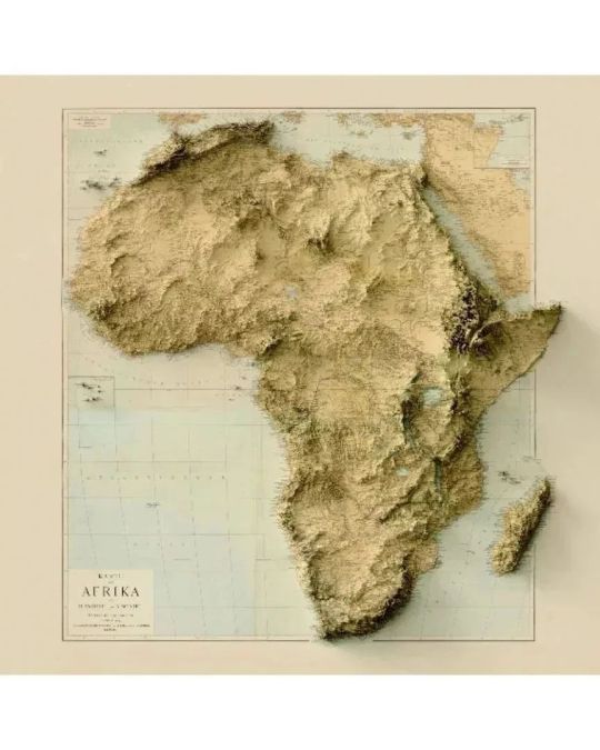
Repost @thinkaboutmaps —— Exaggerated relief maps by @thinkaboutmapsshop showing almost all the continents. These are old maps with digitally rendered reliefs. Year of the original maps: Africa (1884), North and Central Americas (1911), South America (1907), Europe (1875), Middle East (1916) and Asia and Australia (1939). 🌀 Posters and framed maps available with 20% off and free shipping worldwide (2D maps). Check out the link in our bio! . FOLLOW @thinkaboutmaps and @thinkaboutmapsshop for more! . . . . . . . 🌀 #thinkaboutmapsshop #thinkaboutmaps #3d #art #map #maps #mapping #old #oldmaps #geology #mountain #relief #topography #southamerica #asia #oceania #australia #europe #africa #northamerica #centralamerica #middleeast https://www.instagram.com/p/ClwUqOkylhk/?igshid=NGJjMDIxMWI=
#thinkaboutmapsshop#thinkaboutmaps#3d#art#map#maps#mapping#old#oldmaps#geology#mountain#relief#topography#southamerica#asia#oceania#australia#europe#africa#northamerica#centralamerica#middleeast
2 notes
·
View notes
Photo

Lo nuevo: Petal Maps, el nuevo Google Maps de Huawei. #gogolemaps #petalmaps #huawei #mapping #earth #geo #city #cities #country #climate #weather #thinkaboutmaps #thinkaboutmapsshop #costarica #geek https://t.co/qbe4HTNbV2 https://www.instagram.com/p/CG3VE7OAkiL/?igshid=ise1h35281ox
#gogolemaps#petalmaps#huawei#mapping#earth#geo#city#cities#country#climate#weather#thinkaboutmaps#thinkaboutmapsshop#costarica#geek
0 notes
Video
instagram
(via Think About Maps on Instagram: “Map showing the profile of the Great Lakes 🌀 Source: https://t.co/xlXTzbLEwk. . FOLLOW @thinkaboutmaps and @thinkaboutmapsshop for…”)
3 notes
·
View notes
Photo

Estos son los países que más deforestación han sufrido los últimos 25 años, es aterrador ver como la Amazonía está siendo explotada por los cultivadores de productos como la soja, la palma de aceite y pastos para la ganadería, además de las concesiones mineras, ganadería, hidroeléctricas, deforestación ilegal y la pocas medidas preventivas del gobierno brasileño, hace que muchas zonas antes protegidas estén en riesgo total de ser explotadas por multinacionales y empresas privadas. El caso de Indonesia es aterrador que a sustituido casi un 85% de WWF su selva ecuatorial por cultivos de Palma de aceite, derivando en la pronta extinción de especies autóctonas. Es triste ver esta clase de estadísticas pero es la realidad que vive el planeta, los árboles son la única forma que tiene la tierra y nosotros para respirar y evitar el cambio climático. Te invitamos a que etiquetes 👇a muchas personas para que una vez por todas nos quitemos la vendas y empecemos actuar. 📸: @thinkaboutmaps . . . These are the countries that have suffered the most deforestation in the last 25 years, it is terrifying to see how the Amazon is being exploited by growers of products such as soybeans, oil palm and pastures for livestock, in addition to mining concessions, livestock, hydroelectric, illegal deforestation and the few preventive measures of the Brazilian government, makes many previously protected areas at total risk of being exploited by multinationals and private companies. The case of Indonesia is terrifying that it has replaced almost 85% of WWF its equatorial forest with palm oil crops, resulting in the prompt extinction of native species. It is sad to see this kind of statistics but it is the reality that the planet lives, trees are the only way for the earth and us to breathe and avoid climate change. We invite you to label many people so that once and for all we take off the bandages and start acting. 📸: @thinkaboutmaps
19 notes
·
View notes
Photo

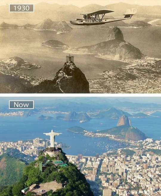
Cities - before and after 1. Rio de Janeiro: 1930 - now 2. Shanghai: 1987 - now 3. New York: 1962 - now 4. Seoul: 1900 - now 5. Jakarta: 1960 - now 🌀 Source: boredpanda.com . FOLLOW @thinkaboutmaps for more! . ▪️connect to us will connect you to "architecture" you "ever" seen from @architecturever_ ▪️subscribe us on YouTube ▪️visit us on www.architecturever.com link in bio ▪️For More Follow : @architecturever_. @greenarchitecturever @natureinspirations_ ▪️Credit Or Removal :( DM ) Or Gmail 📩 #architecturever #greenarchitecturever #greenarchitecture #indianarchitecture #allofarchitecture #sketch_arq #designandlive #Design_Only #futurearchitects2050 #architecture4future #future #architecture #amazing #concept #design #contemporary #instaarchitecture #love #architektur #architect #luxury #architettura #interiordesign #instatravel #travel #architecturestudent #archistudent #archimodel #معماری https://www.instagram.com/p/B3Hv2CaJWLt/?igshid=yyced87atkwu
#architecturever#greenarchitecturever#greenarchitecture#indianarchitecture#allofarchitecture#sketch_arq#designandlive#design_only#futurearchitects2050#architecture4future#future#architecture#amazing#concept#design#contemporary#instaarchitecture#love#architektur#architect#luxury#architettura#interiordesign#instatravel#travel#architecturestudent#archistudent#archimodel#معماری
0 notes
Video
instagram
(via Think About Maps on Instagram: “The 3 tallest mountains - depending on how you measure them by @sketchplanations 🌀 Source: @sketchplanations . FOLLOW @thinkaboutmaps and…”)
2 notes
·
View notes
Video
tumblr
Terremotos ocurridos en el Siglo XX ⌛🌎 y como dibujan perfectamente las placas tectónicas... 📹: @thinkaboutmaps . . . #lafalladesanandrés #terremoto #terremotocentroitalia #terremotoitalia #terremotomexico #earthquake #terremotoenméxico #terremotoecuador #terremotoenmexico #terremotoméxico #mexico #terremotoenecuador #terremotolafalladesanandrés #terremotos #terremoto2015 #ecuador #sismo #geology #geologia #igeologia #geologylove #earthquakenepal #earthquakedamage #earthquaker #earthquake #earthquakerdevices #earthquakes #earthquakerelief #earthquakedevices #earthquakemexico http://bit.ly/2Pj3BIR
3 notes
·
View notes
Photo

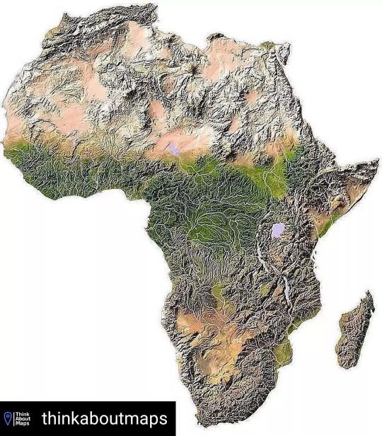
Reposted from @thinkaboutmaps Topographic map of Africa. 🌀 "The average elevation of the continent approximates closely to 600 m (2,000 ft) above sea level, roughly near to the mean elevation of both North and South America, but considerably less than that of Asia, 950 m (3,120 ft). In contrast with other continents, it is marked by the comparatively small area of either very high or very low ground, lands under 180 m (590 ft) occupying an unusually small part of the surface; while not only are the highest elevations inferior to those of Asia or South America, but the area of land over 3,000 m (9,800 ft) is also quite insignificant, being represented almost entirely by individual peaks and mountain ranges. . “As a general rule, the higher tablelands lie to the east and south, while a progressive diminution in altitude towards the west and north is observable. Apart from the lowlands and the Atlas mountain range, the continent may be divided into two regions of higher and lower plateaus, the dividing line (somewhat concave to the north-west) running from the middle of the Red Sea to about 6 deg. S. on the west coast”. 🌀 FOLLOW @thinkaboutmaps and @thinkaboutmapsshop for more! 🌀 #maps #map #mapping #geography #earth #city #cities #country #climatechange #travel #touristic #education #topography #geology #inselberg #germany #africa #main #features #plateau #namibia #egypt #southafrica #geomorfology #plain #kilimanjaro #elevation #mountain #atlasrange https://www.instagram.com/p/Cf011OaLAd4/?igshid=NGJjMDIxMWI=
#maps#map#mapping#geography#earth#city#cities#country#climatechange#travel#touristic#education#topography#geology#inselberg#germany#africa#main#features#plateau#namibia#egypt#southafrica#geomorfology#plain#kilimanjaro#elevation#mountain#atlasrange
0 notes
Video
instagram
메르카토르 도법과 각 나라들의 실제 크기들. 아프리카가 무지 크다는... Reposted from @thinkaboutmaps Video showing the Mercator projection to the true size of each country in relation to all the others. 🌀 Source: @ neilrkaue - https://bit.ly/2Oq206Z . . FOLLOW @thinkaboutmaps for more! 🌀 #maps #map #mapping #geography #earth #city #cities #country #climatechange #travel #mercator #projection #animating #true #size #relaton #africa #canada #europe #southamerica #asia #oceania https://www.instagram.com/p/CaJLO4lAEC5/?utm_medium=tumblr
#maps#map#mapping#geography#earth#city#cities#country#climatechange#travel#mercator#projection#animating#true#size#relaton#africa#canada#europe#southamerica#asia#oceania
0 notes
Photo

The 3 tallest mountains - depending on how you measure them.
by thinkaboutmaps
5K notes
·
View notes