#recessed stucco arch
Explore tagged Tumblr posts
Text
Mediterranean Porch

An example of a huge mediterranean tile screened-in side porch design with a roof extension.
#recessed stucco arch#scroll tile detail#mediterranean screened room#large screen panels#scroll iron porch railing#tuscan screened terrace
0 notes
Photo

Patio - Outdoor Kitchen Inspiration for a huge mediterranean backyard stone patio kitchen remodel with a gazebo
#yellow stucco walls#yellow stucco column#black ceiling fan#lighting in arch#beige granite countertops#orange padded chairs#recessed lighting
0 notes
Photo

Backyard Porch Huge tuscan stone back porch idea with a roof extension
#recessed stucco arches#stone columns#ornate iron screen porch rail#multi level outdoor spaces#chiseled edge wall & column caps#stone planters
0 notes
Text

English Village
3418-3450 Grove Avenue
Built, 1927
Architect, Bascom J. Rowlett
VDHR 127-0374
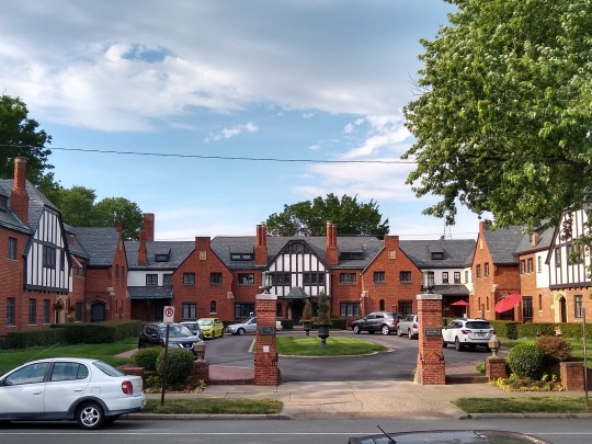
June 2020
Housing ahead of its time.
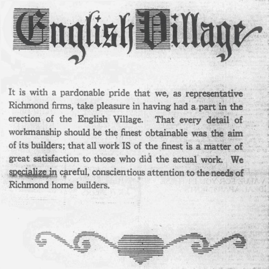
(Newspapers.com) — Richmond Times Dispatch, Sunday, July 10, 1927
The sales prospectus of English Village citing "...the new lifestyle ... while enjoying all the amenities, including privacy of single house living ... with an atmosphere of social respectability..." lt reads like a contemporary advertisement for carefree condominium ownership, yet the ad is over fifty years old.
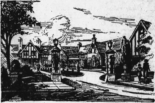
(Newspapers.com) — Richmond Times Dispatch, Sunday, July 10, 1927
Incorporated April 14, 1927, English Village was designed as a cooperative community both for economy and for efficiency while at the same time maintaining a gracious lifestyle. The Village by-laws, still in force, state that "it is the purpose and object of this corporation to maintain and operate the property in English Village on a mutual and cooperative basis.&. without any profits or other gains or remuneration to the corporation, excepting assessments made as hereinafter provided necessary for the upkeep and expense of maintaining the property and providing heat and hot water to the seventeen dwellings located in English Village."

(Newspapers.com) — Richmond Times Dispatch, Sunday, July 10, 1927
This cooperative planned comity was a radical experiment in housing for Richmond as well as for the rest of the country since most of the multi-family housing constructed at the time were apartment complexes in the city or rowhouses in the suburbs.
While many different types of cooperatives in this country enlisted members at the beginning of the 20th century -- credit unions, agricultural co-ops, retail consumers, workers' productive, insurance and others -- cooperative home ownership was a fairly new concept in 1926.
(Newspapers.com) — Richmond Times Dispatch, Sunday, July 10, 1927
At that time, articles appearing in popular periodicals extolling the merits of cooperative apartment ownership, and in 1928, an article appeared in Arts and Decoration entitled, "Cooperatives: the New Way of Buying a Home." The reasons behind cooperative homeownership, the author said, were that they were "...cheaper, more desirable, more flexible in plan... owners realized a savings in rent . . . they had a voice in management." This philosophy had already been espoused by Davis Brothers a year before in their advertisements for English Village.

(Newspapers.com) — Richmond Times Dispatch, Sunday, July 10, 1927
Unlike most of this country's housing co-ops of the 1920s which were built for the working class by industry, philanthropists, or non-profit governmental agencies, English Village was built in the fashionable Grove Avenue neighborhood for the upwardly mobile middle class by private entrepreneurs. According to an article in the real estate section of the Richmond Times Dispatch dated January 23, 1927, English Village would have all the latest modern conveniences including: separate garages; electric refrigeration; community heating; a parked entrance-way as well as "a janitor and cook service on the cooperative plan.
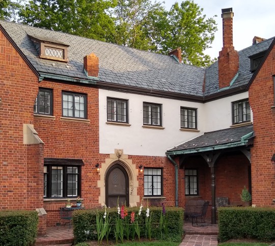
June 2020
Advertised by Davis Brothers as "English Architecture al; its best," the Village was designed by Rowlett, a lesser known Richmond architect, who was noted for a number of fine residences and apartment buildings in Richmond in the 1920s. Reminiscent of the Shelby Apartments of Kingsport, Tennessee, built in 1926, Rowlett's Tudor Revival mannerisms lent variety to the multi-unit complex.

June 2020
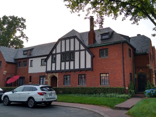
Designed for economy, efficiency, and permanency of building materials without sacrificing aesthetics, the Villas is composed of seventeen attached units two-and-a-half stories high built of brick walls, a distinctive water table, buttressing, prominent gables, and half-timbering in some of the second-story gables. The overall appearance is that, of asymmetry yet the plan is symmetrical with each half being the mirror image of the other. The plan consists of a symmetrical main block and two wings extended forward at each end of the rectangular main block. The wings are asymmetrical but mirror images of each other.

June 2020
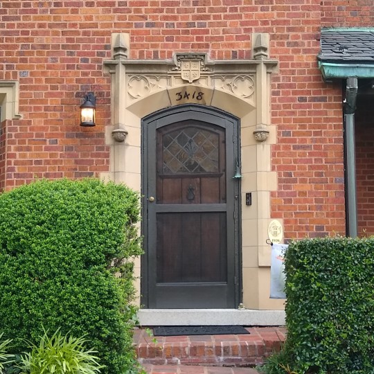
The off-centered doorways are capped with 'Tudor-arched lintels made of cast concrete embellished with designs of lions heads, coats of arms, grape vines, and the diaper motif. Some of the door surrounds are quoinwork of cast cement made to look like stone. The Arts and Crafts philosophy is apparent in the treatment of the doorways.
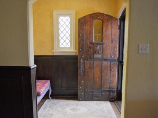
(The English Village)
The doors are board-and-batten with stained-glass windows and wrought-iron strap hinges and thumb latch door handles and knockers. Fenestration on the first and second floors consists of a variety of window shapes and sizes; round-headed windows with leaded stained glass, small narrow rectangular leaded stained-glass windows with label moldings of cast concrete, and metal casement windows set in groups of two's and three's.

June 2020
The cornice in the second story is small and molded. The lines of the gray slate-covered hipped roof are broken by shed dormers, stepped gables, gable ends, some of which have jerkin heads, and large decorative chimney stacks. The focal point of the building is the main block which faces the central courtyard.
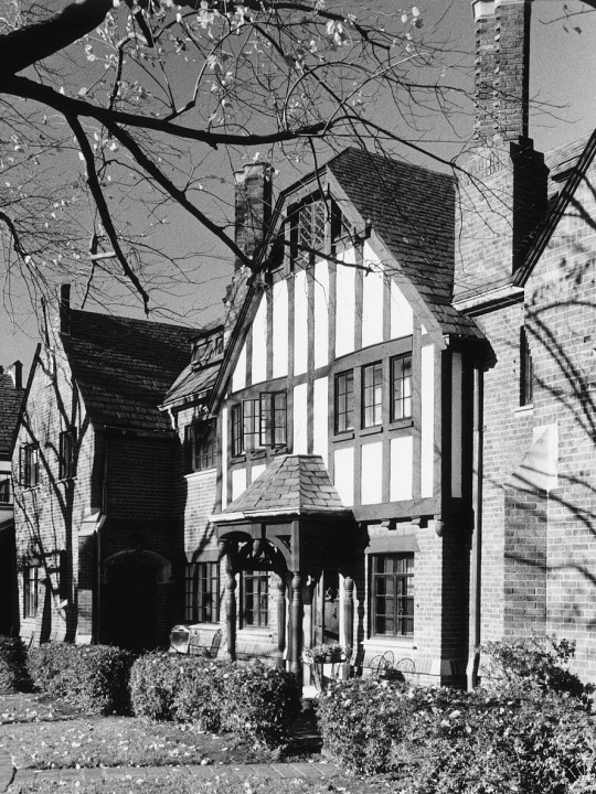
(VDHR) — 1983 VDHR nomination photo
The horizontal lines of the main block are interrupted by the vertical lines of the prominent central gable with second-story half-timbering and the vertical thrusting of the chimney stacks flanking either side of the gable end. The one-bay entrance porch again reflects the Arts and Crafts era with its heavily turned wooden posts with brackets and carved acorns and slate roof. Except for this rather ornate porch, Rowlett gas somewhat restrained in the use of ornamentation, but rather used quality materials for color and texture.

June 2020
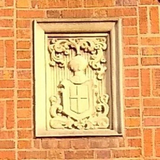
The brickwork is laid in Flemish bond with a tapestry-like pattern in the gable peaks. Cast-cement recessed panels with molded coat of arms designs are also located in the top of the gables. The gutters and downspouts are made of copper. Other uses of ornamentation include a distinctive brick beveled water table which serves, visually, to tie the units together, and brick corbelling under the eaves on the gable ends.
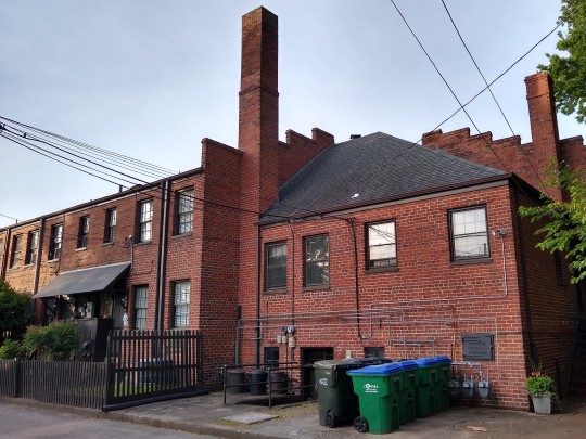
June 2020
The south, east, and west elevations fronting Grove Avenue present the formal side of the Villas, while the north, east, and west elevations facing the rear alley are more utilitarian and resemble the typical rear elevations of rowhouses in Richmond. The plain rectangular common brick walls of the first and second stories are laid in common bond.

June 2020
Simple hoods with brackets shelter the rear doorways. Fenestration consists of 6/6 lights with double-hung sash. Each dwelling has its own private tiny rear patio or garden area enclosed by a picket fence. "Modern refrigeration" boxes are still conveniently located near the back kitchen doors. The furnace room and four-room apartment for the custodian is located on the northwest corner on the rear of the building facing the alley. Seventeen attached brick garages with metal shed roofs are located on the north side of the concrete paved alley.

(Newspapers.com) — Richmond Times Dispatch, Sunday, July 19, 1927
The interior plan which varies slightly for each unit was designed for comfort, convenience, and efficiency and for a servantless lifestyle. One enters through an interior vestibule dimly lit by stained-glass windows. Tudor arched doorways lead from the living room to the dining room to a compact galley-type kitchen at the rear. An open stairway on one side of the living room leads to three bedrooms and a porcelain tiled bathroom upstairs. Some living rooms are equipped with corner fireplaces with cast cement Tudor styled mantels and terra cotta tiled hearths.

(Newspapers.com)
The original mantels were left unpainted to resemble carved stone, however, most of the mantels have been painted over. The ceilings are low with coved ceilings in the hallways, living rooms and dining rooms. Party walls are constructed of cinder block with a stucco finish. The walls were originally painted a cream. The woodwork, including the two-paneled doors with glass door handles, door and window trim , stairway newel post, handrail and turned balusters, was originally stained a dark oak. The creamy walls and the lighter red oak floors were meant to contrast with the darker tones of the doors, windows, and trim.
June 2020
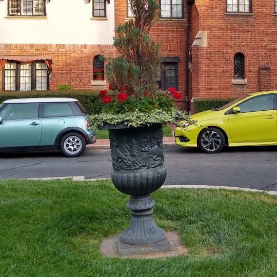
The original landscaping plan consisted of fir, spruce, elm, and hemlock trees combined with ornamental shrubs and lined with terra cotta patios and walkways. A water fountain graced the central courtyard. The circular drive was paved with brick. A playground was located in the northeast corner of the lot behind the buildings. Brick walls enclosed the grounds with a gateway leading to the driveway.

(The Cultural Landscape Foundation) — Charles Gillette
In 1947, the original landscaping plan was altered by Charles Gillette, a Richmond landscape architect. The fountain was removed and replaced by the present flagpole. The driveway was paved with asphalt and the playground no longer exists.

June 2020
The corporate structure and by-laws of English Village Corporation were much the same as that of Garden Homes Cooperative in Milwaukee, one of the first cooperatives in the country, built in the early 1920s. The homeowners in both cases bought shares in the corporation. Besides paying for stock, the homeowners also paid a rental sufficient to cover interest, taxes, insurance, depreciation, repairs and maintenance. But while the home ownership was collective in Milwaukee with no clear title to the property, English Village stockholders retained clear title to their individual properties similar to today s condominium ownership.
June 2020
Since its beginning in 1927, the business of English Village Corporation has been transacted at an annual meeting, or special meeting; if needed, with duly-elected officers and a board of directors managing the property. Each stockholder is assessed one-seventeenth of the total expenses for the maintenance and upkeep of the buildings and grounds.

June 2020
During the depression many of the early owners lost their homes through mortgage foreclosures. However, by 1934, the deeds indicate that all the dwellings were once again owned by families who resided there. The Robert L. Atwell family, original owners of one of the dwellings, managed to hold on to their property and still retain it to this day.
June 2020
English Village Corporation no longer contains all of its restrictive covenants, but it does retain an important one in the original by-laws which has helped maintain the architectural integrity of the building. Homeowners are restricted from making any changes to the exterior of their individual homes which would constitute a departure from and in contrast to the original architectural plan and design of the village structure as a whole. English Village, a product of the era of community consciousness, functionalism, and the Garden Cities ideal, remains an excellent example of an early 20th-century planned cooperative community. (VDHR)
June 2020
A thing of beauty is a joy forever, and that goes double for English Village, still looking good at 93 years young. That’s also true of Architecture Richmond’s write up on this unique Richmond location, a worthy read.
(English Village is part of the Atlas RVA! Project)
2 notes
·
View notes
Photo


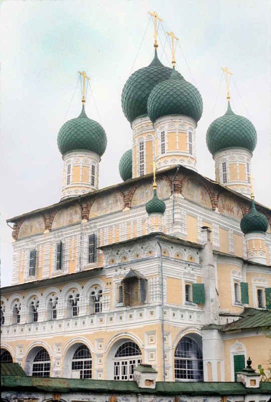


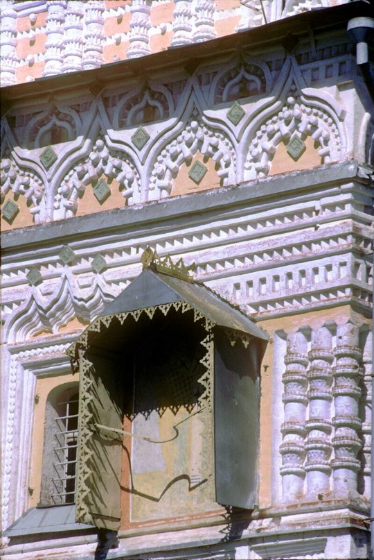


Resurrection of Christ Cathedral (Tutayev, Yaroslavl Oblast):
South-west view, with the bell tower and Holy Gate on the right.
South view, showing the bell tower and Holy Gate.
South-east view, showing St. Nicholas Chapel.
West view.
South view, showing St. Nicholas Chapel.
South view, with decorative details of St. Nicholas Chapel.
Ceiling frescoes from the Book of Genesis in the north gallery.
Frescoes in the west gallery (vault and piers).
Tutayev was originally two settlements located opposite each other on either side of the Volga. On the right bank was Borisoglebsk, and on the left bank was Romanov.
The name “Borisoglebsk” comes from a local wooden church dedicated to Princes Boris and Gleb, who were martyred during a Kievan dynastic struggle in the early 1000s, and later canonized. In the 1400s, the settlement was referred to as the Borisoglebsk Fishing Quarter. The settlement became formally known as Borisoglebsk in 1777, as part of Catherine the Great's administrative reforms of the Russian provinces. In 1822, the two settlements were united as Romanov-Borisoglebsk. The final name change to Tutayev was in 1918, to honour a Red Army soldier killed during the fighting against the Bolsheviks in nearby Yaroslavl.
Borisoglebsk was sacked in the early 1600s during the Time of Troubles, but in the second half of the century it prospered from trade on the Volga. Later in the century was the Schism of the Old Believers, who had a large presence in the region. It is likely that the official church wanted to make a statement that proclaimed the glory of official Orthodoxy, and that was part of the reason for the cathedral's construction.
In 1652, a brick church was built on the site of the wooden Church of Sts. Boris and Gleb. It was dedicated to the Hodegetria Icon (the Smolensk Icon of the Virgin). However, this church suffered a partial collapse in 1670.
After the collapse, a much larger shrine was rebuilt, dedicated to the Resurrection. Walls from the earlier church were used for much of the ground level, and so was the altar dedicated to the Hodegetria Icon. The lower level was used for worship during the rebuilding period. Its secondary altars were dedicated to John the Baptist (in the north) and St. Charalambos of Magnesia.
Construction was finished in 1678. The lower level was used for winter services, as it was easier to heat. The upper level (known as a summer church) contained the main altar, dedicated to the Resurrection of Christ, and a secondary altar dedicated to Sts. Boris and Gleb, in remembrance of the earlier wooden church.
The basic structure of the cathedral has a square plan, rising in a pattern formed by large windows separated by groups of attached ornamental columns, which are painted white on a yellow stuccoed surface. Beneath the roof cornice, there are semicircular gables filled with paintings showing scenes from the life of Christ. These gables can best be seen in the fourth photo, although the details are not visible.
The metal roof has five onion domes (the central one being the highest), which are made up of metal shingles painted dark green. Each dome supports a tall gilded cross. The “drums”, or elevated cylinders, that support the cupolas echo the decorative pattern of the stuccoed walls beneath them. As is common in Yaroslavl architecture, the height of the cupolas, drums and crosses equals the height of the main structure they rest upon.
On the north, south and west façades are shirinki (recessed decorative squares) between the arcaded gallery windows. Many of them contain ceramic tiles. At the east end of the north gallery is a chapel dedicated to Sts. Peter and Paul, and at the east end of the south gallery the chapel is dedicated to St. Nicholas.
On the west and south sides, the elevated galleries are connected via stairways to elaborately decorated porches. The ground level has large arches that emphasize the masonry support for the upper part of the structure.
The south side of the cathedral compound has a Holy Gate facing the main square, and a bell tower with a distinctive “tent” tower, built at the end of the 1600s.
The parish continued to exist during the Soviet era, even though many of its clergy were killed or died in exile during the 1930s. The cathedral survived mostly intact. Locals and pilgrims claim that it has miraculous healing powers.
#history#military history#architecture#christianity#russian civil war#schism of the old believers#russian architecture#russian orthodox church#russia#ussr#yaroslavl oblast#tutayev#prince boris#prince gleb#charalambos
12 notes
·
View notes
Photo


Architecture, Pasadena (No. 6)
144 West Colorado
Constructed: 1910 Tanner Motor Liven Altered: 1929, Bennett and Haskell, architects This two-story Spanish Colonial Revival style building is topped by a tiled shed roof and sheathed in stucco. Constructed in 1910 for the Tanner Motor Livery, the original use is still evident from the two scored-concrete floor areas for washing horses. The facade is symmetrically organized with three large openings on the ground level. The central one is wider than those to each side and originally accommodated the ingress and egress of carriages and then automobiles. Multi-paned wood casement windows are set in pairs on the second story. Cast stone relief work is used as a decorative frieze as well as panels between the windows. The building underwent a certified rehabilitation in 1991.
132-134 West Colorado
Constructed: 1919, R.E. Millsap, architect Altered: 1929, Leo Bachmann, architect This two-story Churrisgueresque style commercial building features a tower element on the east end. The tower is capped by a tiled roof and has two arched openings with multi-paned windows above the iron grille balcony and ground floor entrance. The main storefront is marked by large Baroque frieze of cast concrete depicting shield and portrait medallions topped with twelve finials. The storefront below the frieze has an expansive band of windows and a side entrance with a double-hung window arranged directly above the door. The painted brick rear facade is composed of two windows and a door asymmetrically arranged. The exposed brick east facade features six arched window openings. This building is in good condition and exhibits some of the exuberance of the Spanish Colonial with Baroque detailing. The building underwent a certified rehabilitation in 1986, and was subsequently altered in 1997.
124-128 West Colorado
Constructed: 1923, D.E. Postle, architect This single-story Spanish Colonial Revival style commercial building was constructed to conform to the future street widening. Ornamental scalloped parapets that accentuate the center storefront set off the tiled shed roof. Plain pilasters frame either side of the building, and decorative moldings outline each of the three storefronts. Other details include thick bulkheads, recessed storefront entrances, and scalloped transoms. The building was rehabilitated in 1998
Source
#Tanner Motor Liven#W Colorado Boulevard#Historic Old Pasadena District#usa#Spanish Colonial Revival#original photography#cityscape#detail#landmark#tourist attraction#California#travel#summer 2017#vacation#Churrisgueresque#relief#exterior#facade#architecture#window#roof#stairs#tiles#color#colourful
2 notes
·
View notes
Photo
[id: tweet by Doth (@DothTheDoth) from 06 August 2020: “Life finds a way” with a retweet of a (verified) New York Post (@nypost) tweet of its article: “Medieval ‘wine windows’ are reopening, reviving Italian plague tradition trib.al/T8B4mMt” followed by two pictures of tan hands handing drinks through small arched openings (about one and a half times the height of a wine glass) in walls. The image on the left shows an opening surrounded by a raised concrete rim, incised in radiating lines along the curve of the arch to suggest keystones, with a brass plaque beneath that says “BUCHETTE del VINO WINE WINDOW”. A pale hand with a delicate bracelet accepts the glass of red wine being handed through it. The image on the right has a rough stucco-like texture on the raised rim around the window, which is set in a yellow wall and has the same plaque beneath. Behind the iron window grate around the full-sized window right above the wine window is a blackboard that says “& Cocktails”, and indeed the drink being offered is a cocktail.]/end id.
[id: Eight small images of wine windows, all of a similar size and arched shape, surrounded by thick rims. The first window is in a rough concrete wall with a recessed rim thereof, and the opening sealed with rough stone or concrete. The second window is in a wall of dark rough stone blocks, and has a raised concrete rim with incised lines suggesting stones all around and pointed at the top. It seems to have a flat door deep in the shadowed opening. The third has a pointed raised rim that is pitted and slightly uneven. The opening has been covered with a metal plate that has 12 buzzers with labelled plaques on it. The fourth has a unadorned raised rim and old dark metal cover. The fifth window has been surrounded by a plaster wall so that it sits flush with the wall and has the opening covered with a riveted mailbox door with a slit. The sixth has been similarly plastered around its rough concrete rim, and is closed by a piece of plywood with writing on it. The seventh looks like a slightly shabbier version of the left window seen in the article. The final window has been sealed flush, but the rim is inscribed with “Cantina Brichieri Colombi”, worn down on the final word.]/end id.

133K notes
·
View notes
Text
Putting Names to Built Things: Naming the Architecture and Ornament of Dark Souls and Bloodborne [Part 2]

Above: the Princes’ chamber, from Dark Souls 3.

1. Usually you will see this structure -- what is essentially a boss that has been elongated so that it droops down, much like a stalactite -- in late Gothic vaulting and 16th-/17th-century French and English stucco ceilings. It’s called a pendant, and it’s interestingly applied here as the underside to a wooden entablature.

2. You could call this a baldachin or ciborium. It’s a canopy over a throne, altar, doorway, etc., and can project from a wall or be free-standing (as seen here). A famous real-life example is the baldachin designed by Gian Lorenzo Bernini for the high altar of St. Peter’s Basilica in Rome. A baldachin doesn’t necessarily need to utilize columns; it can also be made of cloth.

3. The narrow, pointed-arch window you see in the back is known as a lancet window. Just think: “lancet” → “lance” → “long and pointy.” Among the Dark Souls trilogy I would say that its most memorable appearance is above Gwyn’s tomb in Dark Souls’ Darkmoon Tomb.

Above: the altar of Ariandel Chapel, from Dark Souls 3.

1. An arrangement similar to the example above. This area enclosing the altar is an apse: a semicircular or polygonal extension to -- or, as this is, termination of -- a larger rectangular space. It’s usually opposite an entrance.

2. All of those sculpted designs you see in the blind arches are tracery -- ornamental intersecting bands in the upper part of a window, screen, or panel, or used decoratively in blind arches and vaults. If it looks “gothic” to you (and it is -- very early Gothic, probably 13th-century-derived), that’s because the design employs foils, those distinctive lobe-/leaf-shaped curves formed by the cusping of a circle or arch. The number of foils involved is indicated by a prefix: here, that’d be trefoil, as there are three (tre-) concave curves.

3. Do the right (...or wrong) things, and a path leading beneath the altar will be opened to you. In general terms, this space is known as a crypt, but because I like to be particular it is actually a confessio, which is a subterranean chamber or recess located below or near the altar. A confessio’s purpose was to shelter a relic, and indeed if you walk to the chamber’s back wall you’ll find an arched recess containing the remains of a (half-dragon?) person.
33 notes
·
View notes
Photo

“Arch Rivals, No.3”
#alcove#arc#arch rivals#arches#Curvature#curve#fence#gate#niche#nook#pavilion#recessed#shadows#stucco#sunlight#Sunnyside#Sunnyside Pavilion#texture#Toronto#waterfront#wrought iron
0 notes
Text
I had a whole bunch of thoughts on what alpha Dave’s house would be like before he’d have to stop living in one place and travel around to avoid the Condesce. (Placed under a readmore for your convenience.)
Before entering the house:
recessed fuschia-tinted lighting along roofline
breezeblock arches, topped by glass tile keystones w/ green LED accents, over all windows
argyle brick driveway
garage made of solid concrete. no entry. it’s just a garage-shaped concrete block.
giant white pixel bust of his own head made of thin hollow plastic in the center of the front yard (chipped and moldy, but somehow refined)
80-foot willow tree (plastic but indistinguishable from the real thing)
rock garden up to porch filled entirely with stupid carved single-word yoga rocks that have been individually vandalized with sharpie
40-foot welcome mat spilling off of the porch and onto the rock garden ("WELCOUMp,.." is in comic sans but only occupies the first 12 feet)
beige stuccoed front double doors
beige stuccoed vertical bar handles on said doors
The entryway:
three story tall foyer (the rest of the house is only one story tall)
three story tall bead curtain immediately inside doorway with a bead shading pattern that looks like a subtle dick
hand cranked wooden gear vertical coat rack (goes up all three stories and holds random clothing)
bronze foot-tall laser-etched statue of Shadow the Hedgehog holding a Gatling gun up with both hands to act as a boot scraper
chandelier that hangs all the way down almost at face level and is missing almost all of the many crystals, with a gas line piping enough fuel for a single chaotic blue flame out of one bulb fixture
key holder, but it's full of those amazon instant purchase buttons for random objects and a number of assorted awards hung up with twine
flying buttress archway into house that points into two carved stone butts
The living room:
grandmotherly flower couch clumsily converted into ceiling swing using only nylon rope
basketball-sized spherical lava lamps on milk crates
airbrush wall mural of Remedios Varo’s 1966 The Candle Game with the heads replaced by Whoopi Goldberg and Grimace
duvet with "jazzy 90's" pattern but the normal white background is replaced with a dim pastel gradient
specially-constructed wildly curved 55" CRT television (always on, picture clearly distorted at sides and colors warped)
angular chaise lounge between TV and couch covered in dirty dishes and empty noodle cups
spray painted filing cabinet filled with movie ideas and doodles next to couch
gas fireplace with a large dyed ceramic Doritos bag as the fake log
The kitchen:
walk-in pantry filled with movie props and one shelf with actual food (he eats takeout a lot and the veggies in the fridge get cycled through with whatever’s fresh)
circular 15' diameter stove island (six electric burners and four gas burners)
5 hamburger phones on the counter ganked into a single tapedeck answering machine for licensing calls
10" television hooked up to hard drive and internet for cooking jams/news plotting/actually seeing TV without horrifying distortion
exercise bike horribly Frankensteined with a Bowflex (also untouched)
If there’s any interest I might do more of this.
#text#hs#alpha dave#dave strider#headcanon#homestuck#alpha timeline#see I can still make original content#sometimes
10 notes
·
View notes
Text
Tomb of Asif Khan
The Tomb of Asif Khan is a mausoleum located in Shahdara Bagh in Lahore, Punjab. It was constructed for the Mughal statesman Abul-Hasan ibn Mirza Ghiyas Beg, who was titled Asif Khan.Asif Khan was the brother of Empress Nur Jahan, and father of Arjumand Bano Begum, who became the consort of Shah Jahan under the name Mumtaz Mahal. In 1636, he was elevated as Khan-e-Khana and commander-in-chief and a year later became the governor of Lahore.
Asif Khan died on 12 June 1641 in a battle against the forces of rebel Raja Jagat Singh. His tomb was commissioned to be built in the Shahdara tomb complex in Lahore by Shah Jahan. It was built to the west of the tomb of Jahangir, facing it. It took four years and was completed in 1645 at a cost of 0.3 million rupees. Some historians believe that Maharajah Ranjit Singh plundered his tomb for its marble and sandstone to be used in his building projects.[1]Today the tomb and the walls as well as the main gate are dilapidated. The tomb, along with the adjacent Akbari Sarai and the Tomb of Jahangir, is on the tentative list as a UNESCO World Heritage Site.[2]
Architecture
The tomb is built entirely of brick. The main chamber is of octagonal plan, with a large central double-layered bulbous dome. It stands in the centre of a large Mughal garden, which is divided into four squares. Octagonal tombs were never used for emperors but they were commonly employed for burial of high-ranking noblemen such as Asaf Khan. The bulbous dome that crowns the tomb is an innovation of Shah Jahan's era that was used to great effect at other sites such as the Taj Mahal. [3]It once had a water reservoir, which fed into fountains and pathways. The floor of the platform on which the tomb stands was created in Sang-e Abri, while the outer walls were covered with red sandstone.
Each side has a deeply recessed iwan, or alcove, with a door and arched window looking into the tomb. The exterior originally was adorned with marble stone inlay work and veneered with stucco tracery, and blue kashi tiles typical of Lahore. The floors were decorated with marble, inlaid with precious stones.[4]The interior was renowned for its lavish use of white marble and precious stone inlay, which has since disappeared. The inner dome ceiling is decorated in a high plaster relief of interlacing patterns, but much of it has fallen off. The tomb contains the marble cenotaph, carved with inscriptions from the Qur'an, similar to that in Emperor Jahangir's adjacent tomb.
Historian Harold Hargreaves says about the tomb, "Despite its simplicity, there is a sense of restful quietude at this site (Asif Khan's Tomb) which renders it one of the most fascinating monuments in the neighborhood of Lahore."[citation needed]
0 notes
Text
ATV Accident Lawyer Sandy Utah
Sandy is located at the base of the Wasatch Mountains thirteen miles south of Salt Lake City; Sandy was a likely area for early settlement. The area was first used by nomadic bands of Paiute, Shoshone, and Bannock Indians who roamed along the base of the mountains as they traveled from their winter home at Utah Lake to their summer fishing grounds at Bear Lake. Permanent settlers first moved into Sandy during the 1860s and 1870s because of the availability of land in the less crowded southern end of the Salt Lake Valley.
youtube
The original plat was essentially one square mile, situated on an alluvial terrace running north and south along the eastern edge of the Jordan River drainage system and paralleling the mountain range. Farmers willing to try their hand at the thirsty soil that inspired Sandy’s name took up land along State Street, which stretched from downtown Salt Lake City to Point of the Mountain. But it was mining that shaped Sandy’s first four decades. When silver mining began in Little Cottonwood Canyon, entrepreneurs recognized Sandy’s value as a supply station; soon its main street was lined with hotels, saloons, and brothels serving miners ready to spend their newly earned wages. Three major smelters were located in Sandy the Flagstaff, the Mingo, and the Saturn making Sandy the territory’s most significant smelting center for a number of years. Sandy was incorporated in 1893, largely as part of an effort to combat what Mormon inhabitants considered “unsavory” elements in the town. Due to its mine-based beginnings, Sandy was somewhat of a boom town, unlike the majority of other rural Utah towns. After incorporation, it was almost as if Sandy had redefined itself. Gone were the large numbers of single, transient men. By 1900 there were only a handful of saloons and hotels, and Sandy began to more closely resemble other rural Utah towns–a place where everyone knew everyone else.
youtube
Church, farming, business, and family formed the focus of the inhabitants’ world. In the late 1960s, however, this rural town dramatically changed course with its second boom. It had always been assumed by local leaders and citizens that Sandy would grow outward from its logical and historic center the nexus of Main and Center streets. However, population growth overwhelmed the physical center as neighborhoods spread out in every direction over the land. Sandy High School students originally attended Jordan High School, which was completed in 1913. In 1962 Hillcrest High School was completed, followed by Brighton in 1969 and Alta in 1978. Sandy students attend seven middle schools and over a dozen elementary schools. The community is served by a new modern library completed in 1991. Sandy’s major employers at the present are Alta View Hospital, Becton Dickinson/Deseret Medical, Economy Builders Supply, Jordan School District, MacManagement, Sandy City, Shopko, Wasatch Building Products, Inc., Western Rehabilitation Institute, Discover Card, and the South Towne Mall. The Sandy Historic District was listed on the National Register of Historic Places in 2006. Portions of the content on this web page were adapted from a copy of the original nomination document. The Sandy Historic District is located in the northeast section of Sandy, twelve miles south of Salt Lake City. The original square mile of the historic city is contained within its boundaries. The Salt Lake valley lies between the Oquirrh Mountains on the west and the Wasatch Mountains to the east. The entrances of Big and Little Cottonwood canyons with their historic mining areas are directly to the east of Sandy and those of Bingham Canyon across the valley to the west.
youtube
The UTA Salt Lake valley light rail system, TRAX, runs along a previously under-utilized railway corridor on a slight diagonal through the Sandy Historic District, and the “Historic Sandy” (9000 South) TRAX station is found in the district. The station itself is not historic but named after the oldest section of the city, the area of the Sandy Historic District. In a similar pattern to other towns in Utah, the majority of streets in the Sandy Historic District are laid out in an orthogonal grid. Sandy streets are narrower, however, and the blocks are smaller than the ten-acre blocks in Salt Lake City to the north. The street numbering in Sandy originally began at the commercial intersection of Main and Center Streets. There are four parks in the Sandy Historic District: Main Street Park, Bicentennial Park, Center Street Park, and Sandy Station Park. The Sandy Historic District runs along the east side of State Street on the west, along both sides of Pioneer Avenue (8530 South) on the north, from the north side of 9000 South on the south and 280 East to the east. To the east of 280 east, the district covers buildings on either side of the older streets of 8680 South, 8800 South and Locust Street between 280 East and 700 east. The boundaries of the Sandy Historic District have been drawn to encompass the highest concentration of historic buildings in Sandy. The Sandy Historic District is composed of residential, commercial, and institutional buildings from two primary construction phases based on the Sandy City multiple property submissions: “The Mining, Smelting and Small Farm Era c.1871-1910″ context and the “Agriculture, Small Business and Community Development 1906-1946″ context. (The historic district contexts established in this nomination vary only slightly from the MPS contexts.) There are 540 primary buildings and 170 outbuildings in the district. Single family houses constitute 92 percent of the structures with 11 or 4 percent multi-family residential buildings. The majority of the buildings in the Sandy Historic District, 266: 317 less 51 previously listed buildings), or 54%, and 135 of the outbuildings contribute to the historic character of the district. Out-of-period and altered structures are scattered throughout the area but overall the district retains its historic feeling and association. The oldest known extant buildings in the Sandy Historic District date from this era. Classical styles are found in the earliest Utah buildings from 1847 through 1890 and later. There are 14 buildings with elements of Classical styling identified in the Sandy Historic District. Their forms tend to be gabled with rectangular, symmetrical facades and smooth wall surfaces. House types associated with Classical styles are hall-parlors, cross wings and other relatively plain forms. Victorian eclectic styles were popular in Utah from 1885 to 1910 and 61 of the buildings in the Sandy Historic District use the then fashionable Victorian styles. Victorian Eclectic is the term used to describe a style that combines elements of related styles of the era such as Queen Anne, Italianate, Greek revival and Colonial Revival. They are characterized by asymmetrical facades, irregular massing, segmental arched window openings and patterned wooden shingles on the gable ends. The forms or types of the houses from this era found in the historic district are cross wings, central-block-with-projecting-bays, and central passage types. Some yards contain coops, barns or other buildings related to agricultural activities. Many small businesses built structures in this period. The Sandy City Bank (NR 7/9/1997) at 212 E. Main Street (8720 South) constructed its brick single story Second Renaissance Revival corner building in 1907.
youtube
The brick stucco-covered one-part block, historically known as Anderson’s Meat Market, at 115 E. Main Street (8720 South) has an angled recessed corner entrance, large display windows on both facades, and a stepped parapet. The Sandy Post Office at the corner of Main and Center Streets (123-9 E. Main Street) is a brick one-part block with sign panels, a stepped parapet roof visible on the sides and large plate glass display windows. Bungalows were the most popular house form in Utah in the first quarter of the twentieth century, and Sandy reflects the styling trends in the state with 55 examples of Bungalows in the Sandy Historic District. The characteristic rectangular footprint vernacular Prairie School-style Bungalows usually has a low-pitched hipped roof with wide eaves and a full-width front porch under the main roofline. There are 19 Period Revival cottages in the Sandy Historic District. They are mostly of brick with irregular, picturesque massing and steep front-facing cross gables with asymmetric facades. Period Revival styles are found in Utah from 1890 to 1940 with the greatest number of residential examples built between the wars. The World War II and post war years of the 1940s and 1950s saw the construction of World War II-era cottages and early Ranch houses in Sandy. There are 120 houses in the Sandy Historic District from this era. Most of the explosive population growth in Sandy has been outside of the historic district area although noncontributing and out-of-period buildings appear throughout the Sandy Historic District. Although there are noncontributing buildings in the district, the majority of buildings retains their integrity and contributes to the historic association and feeling of the area. There are 51 buildings within the Sandy Historic District that have been previously listed in the National Register of Historic Places. Because this was the original section of Sandy, the contexts of the historic district closely mirror those of the multiple property submission.
youtube
The district is significant because it comprises the original core of the city. The Sandy Historic District comprises the area initially laid out in 1873 as the town of Sandy, known as the “original square mile.” The history and early development of Sandy City was directly related to economic and social activities that occurred largely outside of the boundaries of Sandy City. Located twelve miles south of Salt Lake City, Sandy is at the crossroads of several mining districts, Bingham Canyon to the west, and the Big and Little Cottonwood canyons to the east. Sandy’s early history and economic development reflected the fortunes of the mining operations. Agriculture, primarily small farms, also existed in the city and, after the closing of the mines and the moving or closing of the smelters, agriculture enabled the city to survive into the twentieth century as Sandy transformed itself from a small mining-dependent town into a large suburban community at the southeast end of the Salt Lake Valley. The buildings of the Sandy Historic District are significant because they are the best concentration of historic buildings and depict the historical development of the city. The collection of buildings provides a good cross section of the architectural styles and types throughout the contextual periods. The concentration of the variety of resources of the historical plat clearly stands out in this now large city (much of the current geographic city boundary of Sandy is a result of post-1960 annexation of surrounding land). The historic district is a contributing resource to the city of Sandy. There was little settlement or civic activity in the Sandy area before the opening of the mines in the Little Cottonwood and Bingham Canyons in the late 1860s. Railroad access providing transportation for ore from the mines to smelters and sampling mills was a key to the growth of Sandy in this time period. In 1871 the Utah Southern Railroad was extended to Sandy providing a direct rail link to Salt Lake City. Due to its central location, a railroad station with rail connections to the mines of Bingham Canyon on the west and the mines of Little Cottonwood Canyon on the east was dedicated in 1873.
youtube
At that time in a survey of the 160-acre Sandy town site, the town had 60 buildings with a population of 250. The success of the mines in the 1870s and the allied operations of smelting and sampling provided industrial jobs for many in Sandy. A service economy grew up to supply the mines as well as providing housing and entertainment for the workers. There were three major smelters and three sampling mills established in Sandy in the 1870s and 1880s, making it a regional center for dealing with ore from the mines in the surrounding canyons. The Flagstaff smelter (440 E. 8680 South, demolished) and the Mingo (or Mountain Chief) opened in 1873 (demolished) and the adjoining Saturn in 1872 (demolished). Hans N. Bjork came to Sandy from Sweden with his two brothers and found a job in the Mingo Smelter. The Pioneer Sampling Mill (demolished) was located at approximately 8580-8680 South 150 East and built in 1874. One of its early managers, Arthur J. Gushing, moved to Sandy in 1880 with his wife, Ellen Major. By 1880 the population of Sandy was 488, almost doubling from the 1873 figures but presumably less than the boom in the mid-1870s. By 1900 it had increased to 1,632. Unlike other communities in Utah at the time that were predominantly Mormon, the population of Sandy included people of other, non-LDS religions. A frame Classical style Congregational Church (8831 South 220 East) was built c.1895 (demolished). The Mormons in Sandy tended to be connected with small family farms and businesses. The non-Mormons (or gentiles as they were known locally) were drawn to Sandy to work with aspects of the mining industry. The first community school was established in 1881 and the first LDS ward in 1882. By the 1890s the mines were beginning to fail and the end of that era changed the character and population of Sandy. The Mingo smelter closed in 1890 and its equipment was sold to the Germania smelter in Murray, two miles to the north. The period ended with the moving of the Bingham Canyon smelting operations to Garfield, near the Great Salt Lake, in 1906. Many of the non-Mormon population of miners and smelter workers left with the decline in the mining industry. As an example of the change in the composition of the town, by 1900 there were only four saloons left of the earlier seventeen establishments. As the mining and smelting operations failed or moved to other towns, small farms sustained Sandy. The Sandy economy diversified from its previous mining economy to that of agriculture and small businesses. The total population of Sandy changed very little between the censuses of 1900 and 1950, growing only from 1,632 to 2,095. During the 1950s the population swelled, bringing the total to 3,322 in 1960. Sugar beet and poultry production grew as well as the businesses that supported them. Local businesses turned to construction with brick, rather than frame, and a number of examples of the early brick commercial buildings are still extant. The Bateman Agriculture & Development Company built a brick early twentieth century commercial one-part block in 1910 at 198 East 8760 South (NR 8/8/96) to house its specialty store, on the site of the former Scott and Anderson Sampling Mill. Iconic photos of the store show George Bateman, paralyzed in a coal wagon accident in 1911, in his wheelchair outside the store. He was the son of the founder and managed the business, living with his family behind the store, until his death in 1938. Many residents combined agriculture and commerce, initially living on agricultural land and later moving to town. William W. Wilson, mayor of Sandy from 1912 to 1922, moved to Sandy in 1877 and had farm land to the east. He and his Swedish wife, Anna Outland, built their frame (now stucco) house in 1907 at 145 E. 8680 South. He served as vice-president and later president of the Sandy City Bank that was built the same year at the corner at 212 E. Main Street (NR 7/9/1997). The bank served businesses across the south end of the valley and showed the role of Sandy as a business center. In 1927 Wilson, after the death of Anna, built a striated brick Prairie School Bungalow for his second wife, Christine, down the street at 113. E. 8680 South. The mining industry continued to influence the population of Sandy, though providing jobs in smelters outside of Sandy for Sandy natives, rather than attracting immigrant workers. George Hansen was born here and worked as a smelter man and runner. He purchased the modest 1903 frame half-crossing at 93 East 8880 South in 1910 and lived there with his wife, Dora Goff, and family until 1919 when he sold to another smelter man, Rowland Hard castle, also a native of Sandy. Florence Marriott Radon was born in Sandy in 1882 and married Lafayette Radon who worked in the grocery and confectionery business as well as a watchman for the U.S. Smelting & Refining Company. Civic improvements helped create a community feeling for the city. The first Salt Lake City streetcar line was extended from Murray to Sandy in 1907, giving quick access to the capital city. The streetcar track came south along State Street and traveled east along Main Street. Lighting of public spaces grew as in 1913 Utah Power and Light installed over 100 streetlights. The Sandy City Post Office was brick one-part-block at 123 East Main Street built c.1914. Typical of early twentieth century commercial one-part blocks, it has a stepped parapet visible on the side walls and recessed sign panels on the facade.
Sandy Utah ATV Injury Attorney Free Consultation
When you need legal help due to an ATV injury in Sandy Utah, please call Ascent Law LLC for your free consultation (801) 676-5506. We want to help you.
Ascent Law LLC 8833 S. Redwood Road, Suite C West Jordan, Utah 84088 United States Telephone: (801) 676-5506
Ascent Law LLC
4.9 stars – based on 67 reviews
Recent Posts
Salt Lake City Family Law Firm
Are Death Records Public Record?
What Is The Fastest Way To Get Out Of Debt?
FLP vs. LLC
How To Get Custody Of Your Child In Utah
Is It Hard To File Chapter 7 In Utah?
Source: https://www.ascentlawfirm.com/atv-accident-lawyer-sandy-utah/
0 notes
Text

Bolling Haxall House
AKA, The Woman’s Club
211 East Franklin Street
Built 1858
VDHR 127-0033
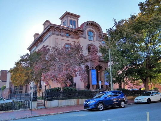
October 2019
Mary Wingfield Scott brings it!
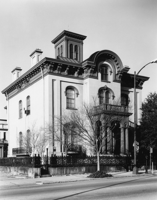
(VDHR) — 1971 nomination photo
The Haxall house is a three-story, Italian Villa style structure of sandstone colored stucco, scored to imitate ashlar. There is a projection for the full height of the building in the center of the entrance facade.
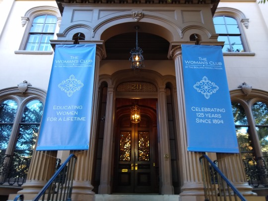
October 2019 — showing raised portico
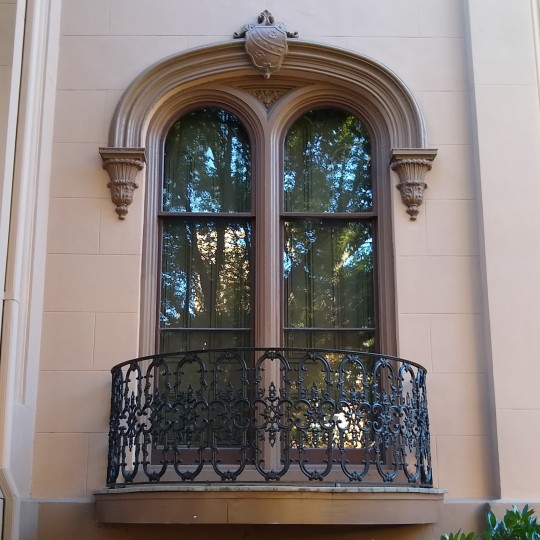
On the first floor level is a raised portico with arched openings, supported by four fluted columns with capitals composed of a simple necking, an egg-and-dart patterned echinus, and a flat abacus. The portico has a panelled entablature with a dentiled cornice. Two large pilasters flank a recess which leads to the front door. The recess is framed by an elliptical arch, sidelights, and pilasters. The front door frame repeats this design in walnut. The door itself is a double one with cutglass and walnut panels.

October 2019 — showing basement windows, semi-circular balcony, & eyebrow windows
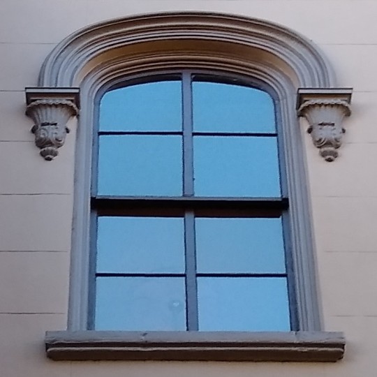
The fenestration of the entrance facade is symmetrical. The basement windows are half-sized with elliptical arches and are devoid of ornament. The windows on the first floor arc double-arched units with cast iron hood mouldings, decorated with coats-of-arms in the centers and pendantls at each end. There are semi-circular balconies with iron railings at,.the bases of the windows. The second floor windows are single-arched with the same hood mouldings, but without the coats-of-arms. They have simple trim and stone sills. The two windows in the projection correspond to the height and treatment of the first and second floors respectively.
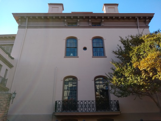
October 2019 — showing dentiled cornice
The house is crowned by an elaborate, double-bracketed, dentiled cornice. The fenestration is continued into the cornice by "eyebrow" windows framed by single brackets. At the top of the central projection, the cornice arches to form a semi-circular pediment. The right wall of the house is blank except for two narrow, semicircular arched windows on the first and second floor levels which are flush with a wing which projects at this point from the house. The windows in both the main body of the house and the .wing are semi-circular arched with hood mouldings, simple trim, and· stone sills. The cornice continues around the main part of the house, but not into the wing. The end wall of the wing is stuccoed "ashlar" and is blank.
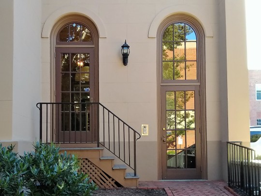
October 2019
The left facade is fenestrated in the same manner as the front of the house with a half basement window, single-arched windows on the first and second floors, and an "eyebrow" window in the cornice. The windows are spaced in the center of the facade so as to form pairs. On the first floor level, there is one long semi-circular balcony for both windows. All the windows have simple hood mouldings and stone sills. The cornice continues. The auditorium entrance joins 'the house at the end of this side.
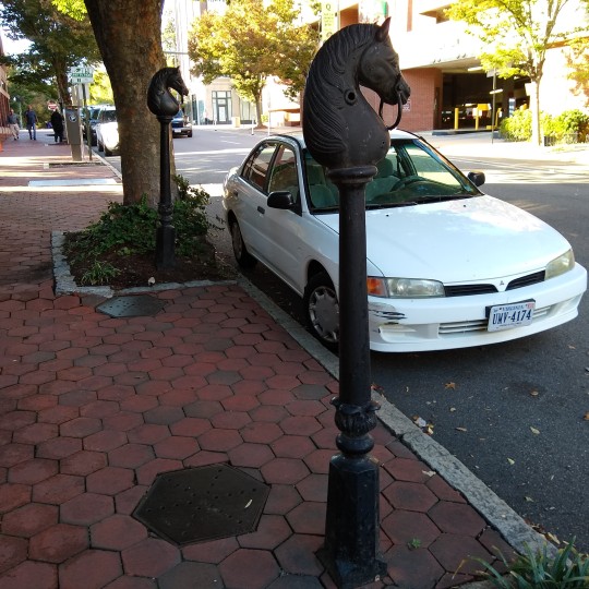
October 2019 — showing evil hexagonal bricks & horse hitching posts
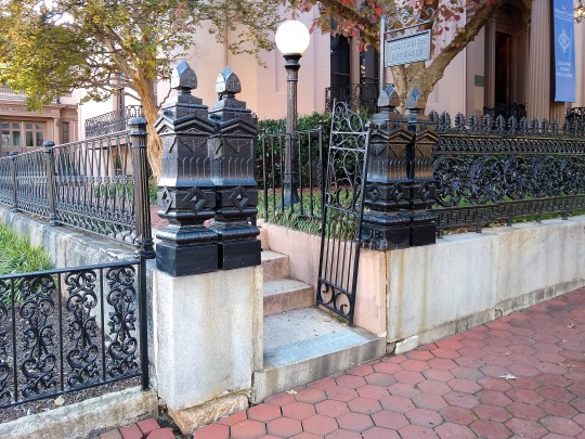
The sidewalk in front of the Bolling Haxall house was originally paved in hexagonal bricks. These unusual paving blocks were regarded as evil by some members of the Richmond populace, and nurses would lead their charges into the gutter rather than have them traverse the bricks of ill omen.
Today, there are two cast-iron, horse-head hitching posts in front of the house. These once stood on Capitol Street where they were used for the horses of the state legislators. There is a fine cast-iron fence set in granite around the fronof the house. This iron-work is believed to have been cast by George Lownes, who did a similar, signed fence in Hollywood Cemetery.
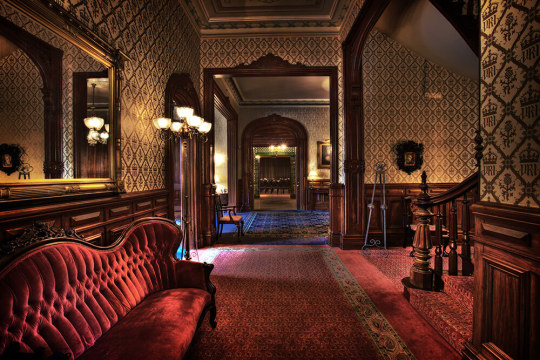
(Richmond Weddings)
The first floor of the interior of the Haxall house consists of a long entrance hall running the length of the house from the front door to the back porch. To the right of the entrance is an octagonal-shaped library, and to the left is a double parlour, separated by sliding doors. Beyond the library on the right-hand side is the semi-circular stair hall with sculptural niches and the walnut stairway added during Dr. Willis' residence. At the top of the stairwell is a stained-glass dome. At the rear of the house is a second hall with a fireplace, as well as three, large double doors which originally opened onto the porch and now lead to the auditorium.
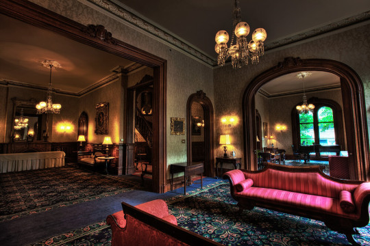
(Richmond Weddings)
The plan of the second floor is similar to that of the first, except that the partition has been removed between the double parlour in order to form a larger room for parties and meetings.
In addition to the double-spiral, walnut staircase and the dome preserved from Dr. Willis' day, the panelled walnut wainscoting which he added to the walls of the entrance and stair halls also remains. The doors and door frames that face into the entrance area are panelled and carved in walnut.
October 2019
The octagonal library on the first floor has been restored to its nineteenth century appearance. The original, carved, pink marble mantel is complemented by a patterned ceiling painted in subtle browns, beiges, pinks, and greens. The walls are painted in shades of brown, beige, and white to imitate panelling. There are walnut, glass-front bookcases in four of the corners of the room.
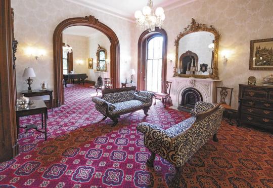
(Richmond Weddings)
The double parlours have elaborately carved, white marble mantels. The doors and windows have white trim with small colonettes at the sides leading up to a cartouche in the center of an elliptical arch. This same design is used with slight variation for all of the door and window frames on the first floor.
There is a cove moulding around the top of all the first floor ceilings and plaster work around the bases of the crystal chandeliers. The second floor is much simpler in its decorative treatment. The three fireplaces are all of white marble in a simple design. The frames of the doors and windows are squared-off, not arched as on the first floor, and have only a plain moulding.
October 2019
When repairs and redecorating of the club were undertaken in 1961 and 1962, the walls of the octagonal-shaped library were discovered to have been painted to simulate paneling in the nineteenth century. The ceiling also yielded evidence of painting in an elaborate design. The walls were repapered at first, but in 1965-1966, Miss Mary Wingfield Scott made it possible for the library to be returned to its original decor.
October 2019
In 1965-1966, the House Committee of the club supervised major structural and redecorating repairs to the house. The cupola was strengthened and repainted, deteriorated cornice mouldings and dentils were replaced, and the exterior of the building was restored to its original sandstone color (obtained from iron filings) with the stucco finish scored to imitate ashlar. Curved iron details over the windows were discovered, and the cast iron balconies around the windows were made visible by the removal of box bushes.
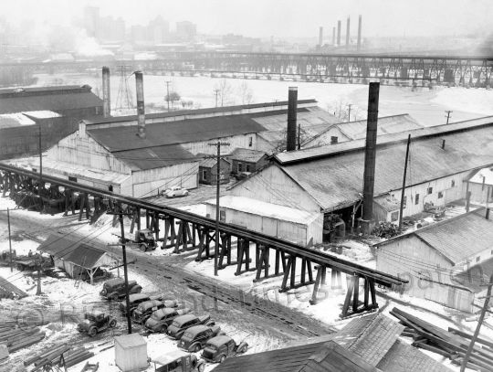
(Pinterest) — Old Dominion Nail Works, February 1948
Bolling W. Haxall was the fifth son of a prosperous mill owner, Philip Haxall. The former Haxall began his career as a clerk in the Haxal Mills and became a partner in 1842. He had a wide range of business talents 'for he was also the president of the Old Dominion Iron and Nail Works and had an interest in the Richmond and Petersburg Railroad. His obituary in the Dispatch of June, 1885, referred to him as “a most energetic successful man of business, whose advice was often sought and highly valued. His house is a testimony to his material success and to the taste of the time.
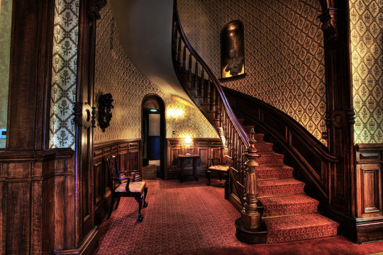
(Richmond Weddings) — showing walnut stairway
Haxall sold his house to Dr. Francis T. Willis in 1869 and I moved to the block west, across from Linden Row. Dr. Willis made several changes in the house. He added a beautiful walnut stairway and frescoed walls with hardwood wainscoting on the main floor. His eye for beauty led to tragedy, however, for his daughter, Emily, a sleepwalker, was killed in a fall down the curving staircase. In despair, Dr. Willis sold the house in i900 to the Woman's Club, which had: been formed by Mrs. L. L. Lewis in 1894 for the literary culture of its members; for their intellectual, social, and moral development, and to strengthen their individual efforts for humanity.
To pay off their mortgage, the ladies of the club rented the second and third floors of the house and the outbuildings as apartments In 1916, the burgeoning enrollment of the club required the addition of an auditorium to the back of the house. This partially destroyed. the rear porches on two floors.
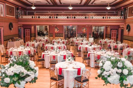
(Richmond Weddings) — auditorium
The auditorium was enlarged in 1924. 1928 saw some major changes on the interior of the Bolling Haxall house. A partition was removed from.between the double parlour on the second floor in order to make a large assembly room- The third floor was converted into studios with a separate entry and stairway, and a balcony was added to the auditorium. (VDHR)
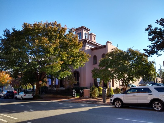
October 2019 — trees giving us the finger
Yet as wonderful as the Women’s Club truly is, it has clearly been targeted by the Insidious Tree-Architecture Conspiracy, that dread cabal that has conifers everywhere laughing at the human species. What can you do but shake your fist in silent rage?
(Bolling Haxall House is part of the Atlas RVA! Project)
5 notes
·
View notes
Text
ATV Accident Lawyer Sandy Utah
Sandy is located at the base of the Wasatch Mountains thirteen miles south of Salt Lake City; Sandy was a likely area for early settlement. The area was first used by nomadic bands of Paiute, Shoshone, and Bannock Indians who roamed along the base of the mountains as they traveled from their winter home at Utah Lake to their summer fishing grounds at Bear Lake. Permanent settlers first moved into Sandy during the 1860s and 1870s because of the availability of land in the less crowded southern end of the Salt Lake Valley.
youtube
The original plat was essentially one square mile, situated on an alluvial terrace running north and south along the eastern edge of the Jordan River drainage system and paralleling the mountain range. Farmers willing to try their hand at the thirsty soil that inspired Sandy’s name took up land along State Street, which stretched from downtown Salt Lake City to Point of the Mountain. But it was mining that shaped Sandy’s first four decades. When silver mining began in Little Cottonwood Canyon, entrepreneurs recognized Sandy’s value as a supply station; soon its main street was lined with hotels, saloons, and brothels serving miners ready to spend their newly earned wages. Three major smelters were located in Sandy the Flagstaff, the Mingo, and the Saturn making Sandy the territory’s most significant smelting center for a number of years. Sandy was incorporated in 1893, largely as part of an effort to combat what Mormon inhabitants considered “unsavory” elements in the town. Due to its mine-based beginnings, Sandy was somewhat of a boom town, unlike the majority of other rural Utah towns. After incorporation, it was almost as if Sandy had redefined itself. Gone were the large numbers of single, transient men. By 1900 there were only a handful of saloons and hotels, and Sandy began to more closely resemble other rural Utah towns–a place where everyone knew everyone else.
youtube
Church, farming, business, and family formed the focus of the inhabitants’ world. In the late 1960s, however, this rural town dramatically changed course with its second boom. It had always been assumed by local leaders and citizens that Sandy would grow outward from its logical and historic center the nexus of Main and Center streets. However, population growth overwhelmed the physical center as neighborhoods spread out in every direction over the land. Sandy High School students originally attended Jordan High School, which was completed in 1913. In 1962 Hillcrest High School was completed, followed by Brighton in 1969 and Alta in 1978. Sandy students attend seven middle schools and over a dozen elementary schools. The community is served by a new modern library completed in 1991. Sandy’s major employers at the present are Alta View Hospital, Becton Dickinson/Deseret Medical, Economy Builders Supply, Jordan School District, MacManagement, Sandy City, Shopko, Wasatch Building Products, Inc., Western Rehabilitation Institute, Discover Card, and the South Towne Mall. The Sandy Historic District was listed on the National Register of Historic Places in 2006. Portions of the content on this web page were adapted from a copy of the original nomination document. The Sandy Historic District is located in the northeast section of Sandy, twelve miles south of Salt Lake City. The original square mile of the historic city is contained within its boundaries. The Salt Lake valley lies between the Oquirrh Mountains on the west and the Wasatch Mountains to the east. The entrances of Big and Little Cottonwood canyons with their historic mining areas are directly to the east of Sandy and those of Bingham Canyon across the valley to the west.
youtube
The UTA Salt Lake valley light rail system, TRAX, runs along a previously under-utilized railway corridor on a slight diagonal through the Sandy Historic District, and the “Historic Sandy” (9000 South) TRAX station is found in the district. The station itself is not historic but named after the oldest section of the city, the area of the Sandy Historic District. In a similar pattern to other towns in Utah, the majority of streets in the Sandy Historic District are laid out in an orthogonal grid. Sandy streets are narrower, however, and the blocks are smaller than the ten-acre blocks in Salt Lake City to the north. The street numbering in Sandy originally began at the commercial intersection of Main and Center Streets. There are four parks in the Sandy Historic District: Main Street Park, Bicentennial Park, Center Street Park, and Sandy Station Park. The Sandy Historic District runs along the east side of State Street on the west, along both sides of Pioneer Avenue (8530 South) on the north, from the north side of 9000 South on the south and 280 East to the east. To the east of 280 east, the district covers buildings on either side of the older streets of 8680 South, 8800 South and Locust Street between 280 East and 700 east. The boundaries of the Sandy Historic District have been drawn to encompass the highest concentration of historic buildings in Sandy. The Sandy Historic District is composed of residential, commercial, and institutional buildings from two primary construction phases based on the Sandy City multiple property submissions: “The Mining, Smelting and Small Farm Era c.1871-1910″ context and the “Agriculture, Small Business and Community Development 1906-1946″ context. (The historic district contexts established in this nomination vary only slightly from the MPS contexts.) There are 540 primary buildings and 170 outbuildings in the district. Single family houses constitute 92 percent of the structures with 11 or 4 percent multi-family residential buildings. The majority of the buildings in the Sandy Historic District, 266: 317 less 51 previously listed buildings), or 54%, and 135 of the outbuildings contribute to the historic character of the district. Out-of-period and altered structures are scattered throughout the area but overall the district retains its historic feeling and association. The oldest known extant buildings in the Sandy Historic District date from this era. Classical styles are found in the earliest Utah buildings from 1847 through 1890 and later. There are 14 buildings with elements of Classical styling identified in the Sandy Historic District. Their forms tend to be gabled with rectangular, symmetrical facades and smooth wall surfaces. House types associated with Classical styles are hall-parlors, cross wings and other relatively plain forms. Victorian eclectic styles were popular in Utah from 1885 to 1910 and 61 of the buildings in the Sandy Historic District use the then fashionable Victorian styles. Victorian Eclectic is the term used to describe a style that combines elements of related styles of the era such as Queen Anne, Italianate, Greek revival and Colonial Revival. They are characterized by asymmetrical facades, irregular massing, segmental arched window openings and patterned wooden shingles on the gable ends. The forms or types of the houses from this era found in the historic district are cross wings, central-block-with-projecting-bays, and central passage types. Some yards contain coops, barns or other buildings related to agricultural activities. Many small businesses built structures in this period. The Sandy City Bank (NR 7/9/1997) at 212 E. Main Street (8720 South) constructed its brick single story Second Renaissance Revival corner building in 1907.
youtube
The brick stucco-covered one-part block, historically known as Anderson’s Meat Market, at 115 E. Main Street (8720 South) has an angled recessed corner entrance, large display windows on both facades, and a stepped parapet. The Sandy Post Office at the corner of Main and Center Streets (123-9 E. Main Street) is a brick one-part block with sign panels, a stepped parapet roof visible on the sides and large plate glass display windows. Bungalows were the most popular house form in Utah in the first quarter of the twentieth century, and Sandy reflects the styling trends in the state with 55 examples of Bungalows in the Sandy Historic District. The characteristic rectangular footprint vernacular Prairie School-style Bungalows usually has a low-pitched hipped roof with wide eaves and a full-width front porch under the main roofline. There are 19 Period Revival cottages in the Sandy Historic District. They are mostly of brick with irregular, picturesque massing and steep front-facing cross gables with asymmetric facades. Period Revival styles are found in Utah from 1890 to 1940 with the greatest number of residential examples built between the wars. The World War II and post war years of the 1940s and 1950s saw the construction of World War II-era cottages and early Ranch houses in Sandy. There are 120 houses in the Sandy Historic District from this era. Most of the explosive population growth in Sandy has been outside of the historic district area although noncontributing and out-of-period buildings appear throughout the Sandy Historic District. Although there are noncontributing buildings in the district, the majority of buildings retains their integrity and contributes to the historic association and feeling of the area. There are 51 buildings within the Sandy Historic District that have been previously listed in the National Register of Historic Places. Because this was the original section of Sandy, the contexts of the historic district closely mirror those of the multiple property submission.
youtube
The district is significant because it comprises the original core of the city. The Sandy Historic District comprises the area initially laid out in 1873 as the town of Sandy, known as the “original square mile.” The history and early development of Sandy City was directly related to economic and social activities that occurred largely outside of the boundaries of Sandy City. Located twelve miles south of Salt Lake City, Sandy is at the crossroads of several mining districts, Bingham Canyon to the west, and the Big and Little Cottonwood canyons to the east. Sandy’s early history and economic development reflected the fortunes of the mining operations. Agriculture, primarily small farms, also existed in the city and, after the closing of the mines and the moving or closing of the smelters, agriculture enabled the city to survive into the twentieth century as Sandy transformed itself from a small mining-dependent town into a large suburban community at the southeast end of the Salt Lake Valley. The buildings of the Sandy Historic District are significant because they are the best concentration of historic buildings and depict the historical development of the city. The collection of buildings provides a good cross section of the architectural styles and types throughout the contextual periods. The concentration of the variety of resources of the historical plat clearly stands out in this now large city (much of the current geographic city boundary of Sandy is a result of post-1960 annexation of surrounding land). The historic district is a contributing resource to the city of Sandy. There was little settlement or civic activity in the Sandy area before the opening of the mines in the Little Cottonwood and Bingham Canyons in the late 1860s. Railroad access providing transportation for ore from the mines to smelters and sampling mills was a key to the growth of Sandy in this time period. In 1871 the Utah Southern Railroad was extended to Sandy providing a direct rail link to Salt Lake City. Due to its central location, a railroad station with rail connections to the mines of Bingham Canyon on the west and the mines of Little Cottonwood Canyon on the east was dedicated in 1873.
youtube
At that time in a survey of the 160-acre Sandy town site, the town had 60 buildings with a population of 250. The success of the mines in the 1870s and the allied operations of smelting and sampling provided industrial jobs for many in Sandy. A service economy grew up to supply the mines as well as providing housing and entertainment for the workers. There were three major smelters and three sampling mills established in Sandy in the 1870s and 1880s, making it a regional center for dealing with ore from the mines in the surrounding canyons. The Flagstaff smelter (440 E. 8680 South, demolished) and the Mingo (or Mountain Chief) opened in 1873 (demolished) and the adjoining Saturn in 1872 (demolished). Hans N. Bjork came to Sandy from Sweden with his two brothers and found a job in the Mingo Smelter. The Pioneer Sampling Mill (demolished) was located at approximately 8580-8680 South 150 East and built in 1874. One of its early managers, Arthur J. Gushing, moved to Sandy in 1880 with his wife, Ellen Major. By 1880 the population of Sandy was 488, almost doubling from the 1873 figures but presumably less than the boom in the mid-1870s. By 1900 it had increased to 1,632. Unlike other communities in Utah at the time that were predominantly Mormon, the population of Sandy included people of other, non-LDS religions. A frame Classical style Congregational Church (8831 South 220 East) was built c.1895 (demolished). The Mormons in Sandy tended to be connected with small family farms and businesses. The non-Mormons (or gentiles as they were known locally) were drawn to Sandy to work with aspects of the mining industry. The first community school was established in 1881 and the first LDS ward in 1882. By the 1890s the mines were beginning to fail and the end of that era changed the character and population of Sandy. The Mingo smelter closed in 1890 and its equipment was sold to the Germania smelter in Murray, two miles to the north. The period ended with the moving of the Bingham Canyon smelting operations to Garfield, near the Great Salt Lake, in 1906. Many of the non-Mormon population of miners and smelter workers left with the decline in the mining industry. As an example of the change in the composition of the town, by 1900 there were only four saloons left of the earlier seventeen establishments. As the mining and smelting operations failed or moved to other towns, small farms sustained Sandy. The Sandy economy diversified from its previous mining economy to that of agriculture and small businesses. The total population of Sandy changed very little between the censuses of 1900 and 1950, growing only from 1,632 to 2,095. During the 1950s the population swelled, bringing the total to 3,322 in 1960. Sugar beet and poultry production grew as well as the businesses that supported them. Local businesses turned to construction with brick, rather than frame, and a number of examples of the early brick commercial buildings are still extant. The Bateman Agriculture & Development Company built a brick early twentieth century commercial one-part block in 1910 at 198 East 8760 South (NR 8/8/96) to house its specialty store, on the site of the former Scott and Anderson Sampling Mill. Iconic photos of the store show George Bateman, paralyzed in a coal wagon accident in 1911, in his wheelchair outside the store. He was the son of the founder and managed the business, living with his family behind the store, until his death in 1938. Many residents combined agriculture and commerce, initially living on agricultural land and later moving to town. William W. Wilson, mayor of Sandy from 1912 to 1922, moved to Sandy in 1877 and had farm land to the east. He and his Swedish wife, Anna Outland, built their frame (now stucco) house in 1907 at 145 E. 8680 South. He served as vice-president and later president of the Sandy City Bank that was built the same year at the corner at 212 E. Main Street (NR 7/9/1997). The bank served businesses across the south end of the valley and showed the role of Sandy as a business center. In 1927 Wilson, after the death of Anna, built a striated brick Prairie School Bungalow for his second wife, Christine, down the street at 113. E. 8680 South. The mining industry continued to influence the population of Sandy, though providing jobs in smelters outside of Sandy for Sandy natives, rather than attracting immigrant workers. George Hansen was born here and worked as a smelter man and runner. He purchased the modest 1903 frame half-crossing at 93 East 8880 South in 1910 and lived there with his wife, Dora Goff, and family until 1919 when he sold to another smelter man, Rowland Hard castle, also a native of Sandy. Florence Marriott Radon was born in Sandy in 1882 and married Lafayette Radon who worked in the grocery and confectionery business as well as a watchman for the U.S. Smelting & Refining Company. Civic improvements helped create a community feeling for the city. The first Salt Lake City streetcar line was extended from Murray to Sandy in 1907, giving quick access to the capital city. The streetcar track came south along State Street and traveled east along Main Street. Lighting of public spaces grew as in 1913 Utah Power and Light installed over 100 streetlights. The Sandy City Post Office was brick one-part-block at 123 East Main Street built c.1914. Typical of early twentieth century commercial one-part blocks, it has a stepped parapet visible on the side walls and recessed sign panels on the facade.
Sandy Utah ATV Injury Attorney Free Consultation
When you need legal help due to an ATV injury in Sandy Utah, please call Ascent Law LLC for your free consultation (801) 676-5506. We want to help you.
Ascent Law LLC 8833 S. Redwood Road, Suite C West Jordan, Utah 84088 United States Telephone: (801) 676-5506
Ascent Law LLC
4.9 stars – based on 67 reviews
Recent Posts
Salt Lake City Family Law Firm
Are Death Records Public Record?
What Is The Fastest Way To Get Out Of Debt?
FLP vs. LLC
How To Get Custody Of Your Child In Utah
Is It Hard To File Chapter 7 In Utah?
Source: https://www.ascentlawfirm.com/atv-accident-lawyer-sandy-utah/
0 notes
Photo


Architecture, Pasadena (No. 3)
In marked contrast to the Spanish Colonial Revival facades on either side, this large two-story reinforced building has an Art Deco fa9ade. While some portions of the structure date from 1887, almost all of the recognizable elements of the building are from the 1929 Art Deco construction. Fluted pilasters and a band of relief abstract swirls, zig-zag, flower and wave patterns between the first and second floor make this building one of the best examples of the style within the district. All pilasters and the relief are of poured concrete. A transom runs above the length of the ground floor windows, accented with an Art Deco star-design grill above the center recessed entrance. The second story is marked by a horizontal ribbon of 13 double-hung windows more typical of the Moderne style. The interior of the building was remodeled in the 1980s, but the front facade is intact.
This two-story Spanish Colonial Revival structure is tied to 14-16 E. Colorado Boulevard with its Mission tile shed roof and curved downspouts. Three large, single-pane windows are arranged symmetrically on the second story of the building. The architectural details are almost identical to 14-16 East Colorado Boulevard. The capitals were restored and replaced during its certified rehabilitation in 1985.
This two-story stucco-over-brick building is in the Spanish Colonial Revival style. Architects, Bennett and Haskell designed other buildings in the district; this structure is very similar to 14-16 East Colorado Boulevard. The facade is symmetrically organized about a centrally located entrance to the upper story. The entrance sits in an arched opening topped by decorative relief work. Two each side are storefronts with brackets in the upper corners. Double-hung windows defined by wrought iron railings and twisted columns are arranged symmetrically on the second story. A wide decorative frieze sits below the shed roof, which is fit with red tiles. A contoured molding runs the length of the roofline and in between the two stories. The building underwent a certified rehabilitation in 1984.
This two-story stucco-over-brick Spanish Colonial Revival building is characterized by a decorative boxed cornice at the roofline, which runs just above an ornate frieze. Decorative moldings run above and below the three double-hung windows. Narrow pilasters separate the windows. Wide pilasters with decorative capitals frame the three-light glass panels that comprise most of the first story fa9ade. The recessed entrance is arranged asymmetrically on the far left corner of the street facade. The building was rehabilitated in 1994. The storefront is not original.
This large two-story brick-faced building is accented by classical details throughout. A heavy decorative shell and scalloped pattern comprise the ornamentation at the cornice, parapet, and central entrance. The second story casement windows with narrow transoms are arranged in groups of two and are separated by decorative vertical panels. These concrete panels depict an intricate flower, vase, and scroll design. The same design is used to decorate the flat flush pilasters at the corners and entrances on the first story. Wide transoms and recessed entrances mark the display windows on the first story. The grand, central, recessed entrance to the second story is elaborately decorated with the aforementioned classical frieze and the Richardson name. The building is historically important due to its connection with the Richardson family, a prominent Pasadena family. Harry Horton, the architect of the 1929 remodel, also designed neighboring buildings on the street. The building was rehabilitated in 2000, and again in 2004.
Source
#East Colorado Boulevard#Pasadena#Spanish Colonial Revival#architecture#cityscape#travel#original photography#Historic Old Pasadena District#facade#detail#window#landmark#tourist attraction#summer 2017#usa#California#Scandia Building#Richardson Block#Richardson Building#exterior
2 notes
·
View notes
Text
ATV Accident Lawyer Sandy Utah
Sandy is located at the base of the Wasatch Mountains thirteen miles south of Salt Lake City; Sandy was a likely area for early settlement. The area was first used by nomadic bands of Paiute, Shoshone, and Bannock Indians who roamed along the base of the mountains as they traveled from their winter home at Utah Lake to their summer fishing grounds at Bear Lake. Permanent settlers first moved into Sandy during the 1860s and 1870s because of the availability of land in the less crowded southern end of the Salt Lake Valley.
youtube
The original plat was essentially one square mile, situated on an alluvial terrace running north and south along the eastern edge of the Jordan River drainage system and paralleling the mountain range. Farmers willing to try their hand at the thirsty soil that inspired Sandy’s name took up land along State Street, which stretched from downtown Salt Lake City to Point of the Mountain. But it was mining that shaped Sandy’s first four decades. When silver mining began in Little Cottonwood Canyon, entrepreneurs recognized Sandy’s value as a supply station; soon its main street was lined with hotels, saloons, and brothels serving miners ready to spend their newly earned wages. Three major smelters were located in Sandy the Flagstaff, the Mingo, and the Saturn making Sandy the territory’s most significant smelting center for a number of years. Sandy was incorporated in 1893, largely as part of an effort to combat what Mormon inhabitants considered “unsavory” elements in the town. Due to its mine-based beginnings, Sandy was somewhat of a boom town, unlike the majority of other rural Utah towns. After incorporation, it was almost as if Sandy had redefined itself. Gone were the large numbers of single, transient men. By 1900 there were only a handful of saloons and hotels, and Sandy began to more closely resemble other rural Utah towns–a place where everyone knew everyone else.
youtube
Church, farming, business, and family formed the focus of the inhabitants’ world. In the late 1960s, however, this rural town dramatically changed course with its second boom. It had always been assumed by local leaders and citizens that Sandy would grow outward from its logical and historic center the nexus of Main and Center streets. However, population growth overwhelmed the physical center as neighborhoods spread out in every direction over the land. Sandy High School students originally attended Jordan High School, which was completed in 1913. In 1962 Hillcrest High School was completed, followed by Brighton in 1969 and Alta in 1978. Sandy students attend seven middle schools and over a dozen elementary schools. The community is served by a new modern library completed in 1991. Sandy’s major employers at the present are Alta View Hospital, Becton Dickinson/Deseret Medical, Economy Builders Supply, Jordan School District, MacManagement, Sandy City, Shopko, Wasatch Building Products, Inc., Western Rehabilitation Institute, Discover Card, and the South Towne Mall. The Sandy Historic District was listed on the National Register of Historic Places in 2006. Portions of the content on this web page were adapted from a copy of the original nomination document. The Sandy Historic District is located in the northeast section of Sandy, twelve miles south of Salt Lake City. The original square mile of the historic city is contained within its boundaries. The Salt Lake valley lies between the Oquirrh Mountains on the west and the Wasatch Mountains to the east. The entrances of Big and Little Cottonwood canyons with their historic mining areas are directly to the east of Sandy and those of Bingham Canyon across the valley to the west.
youtube
The UTA Salt Lake valley light rail system, TRAX, runs along a previously under-utilized railway corridor on a slight diagonal through the Sandy Historic District, and the “Historic Sandy” (9000 South) TRAX station is found in the district. The station itself is not historic but named after the oldest section of the city, the area of the Sandy Historic District. In a similar pattern to other towns in Utah, the majority of streets in the Sandy Historic District are laid out in an orthogonal grid. Sandy streets are narrower, however, and the blocks are smaller than the ten-acre blocks in Salt Lake City to the north. The street numbering in Sandy originally began at the commercial intersection of Main and Center Streets. There are four parks in the Sandy Historic District: Main Street Park, Bicentennial Park, Center Street Park, and Sandy Station Park. The Sandy Historic District runs along the east side of State Street on the west, along both sides of Pioneer Avenue (8530 South) on the north, from the north side of 9000 South on the south and 280 East to the east. To the east of 280 east, the district covers buildings on either side of the older streets of 8680 South, 8800 South and Locust Street between 280 East and 700 east. The boundaries of the Sandy Historic District have been drawn to encompass the highest concentration of historic buildings in Sandy. The Sandy Historic District is composed of residential, commercial, and institutional buildings from two primary construction phases based on the Sandy City multiple property submissions: “The Mining, Smelting and Small Farm Era c.1871-1910″ context and the “Agriculture, Small Business and Community Development 1906-1946″ context. (The historic district contexts established in this nomination vary only slightly from the MPS contexts.) There are 540 primary buildings and 170 outbuildings in the district. Single family houses constitute 92 percent of the structures with 11 or 4 percent multi-family residential buildings. The majority of the buildings in the Sandy Historic District, 266: 317 less 51 previously listed buildings), or 54%, and 135 of the outbuildings contribute to the historic character of the district. Out-of-period and altered structures are scattered throughout the area but overall the district retains its historic feeling and association. The oldest known extant buildings in the Sandy Historic District date from this era. Classical styles are found in the earliest Utah buildings from 1847 through 1890 and later. There are 14 buildings with elements of Classical styling identified in the Sandy Historic District. Their forms tend to be gabled with rectangular, symmetrical facades and smooth wall surfaces. House types associated with Classical styles are hall-parlors, cross wings and other relatively plain forms. Victorian eclectic styles were popular in Utah from 1885 to 1910 and 61 of the buildings in the Sandy Historic District use the then fashionable Victorian styles. Victorian Eclectic is the term used to describe a style that combines elements of related styles of the era such as Queen Anne, Italianate, Greek revival and Colonial Revival. They are characterized by asymmetrical facades, irregular massing, segmental arched window openings and patterned wooden shingles on the gable ends. The forms or types of the houses from this era found in the historic district are cross wings, central-block-with-projecting-bays, and central passage types. Some yards contain coops, barns or other buildings related to agricultural activities. Many small businesses built structures in this period. The Sandy City Bank (NR 7/9/1997) at 212 E. Main Street (8720 South) constructed its brick single story Second Renaissance Revival corner building in 1907.
youtube
The brick stucco-covered one-part block, historically known as Anderson’s Meat Market, at 115 E. Main Street (8720 South) has an angled recessed corner entrance, large display windows on both facades, and a stepped parapet. The Sandy Post Office at the corner of Main and Center Streets (123-9 E. Main Street) is a brick one-part block with sign panels, a stepped parapet roof visible on the sides and large plate glass display windows. Bungalows were the most popular house form in Utah in the first quarter of the twentieth century, and Sandy reflects the styling trends in the state with 55 examples of Bungalows in the Sandy Historic District. The characteristic rectangular footprint vernacular Prairie School-style Bungalows usually has a low-pitched hipped roof with wide eaves and a full-width front porch under the main roofline. There are 19 Period Revival cottages in the Sandy Historic District. They are mostly of brick with irregular, picturesque massing and steep front-facing cross gables with asymmetric facades. Period Revival styles are found in Utah from 1890 to 1940 with the greatest number of residential examples built between the wars. The World War II and post war years of the 1940s and 1950s saw the construction of World War II-era cottages and early Ranch houses in Sandy. There are 120 houses in the Sandy Historic District from this era. Most of the explosive population growth in Sandy has been outside of the historic district area although noncontributing and out-of-period buildings appear throughout the Sandy Historic District. Although there are noncontributing buildings in the district, the majority of buildings retains their integrity and contributes to the historic association and feeling of the area. There are 51 buildings within the Sandy Historic District that have been previously listed in the National Register of Historic Places. Because this was the original section of Sandy, the contexts of the historic district closely mirror those of the multiple property submission.
youtube
The district is significant because it comprises the original core of the city. The Sandy Historic District comprises the area initially laid out in 1873 as the town of Sandy, known as the “original square mile.” The history and early development of Sandy City was directly related to economic and social activities that occurred largely outside of the boundaries of Sandy City. Located twelve miles south of Salt Lake City, Sandy is at the crossroads of several mining districts, Bingham Canyon to the west, and the Big and Little Cottonwood canyons to the east. Sandy’s early history and economic development reflected the fortunes of the mining operations. Agriculture, primarily small farms, also existed in the city and, after the closing of the mines and the moving or closing of the smelters, agriculture enabled the city to survive into the twentieth century as Sandy transformed itself from a small mining-dependent town into a large suburban community at the southeast end of the Salt Lake Valley. The buildings of the Sandy Historic District are significant because they are the best concentration of historic buildings and depict the historical development of the city. The collection of buildings provides a good cross section of the architectural styles and types throughout the contextual periods. The concentration of the variety of resources of the historical plat clearly stands out in this now large city (much of the current geographic city boundary of Sandy is a result of post-1960 annexation of surrounding land). The historic district is a contributing resource to the city of Sandy. There was little settlement or civic activity in the Sandy area before the opening of the mines in the Little Cottonwood and Bingham Canyons in the late 1860s. Railroad access providing transportation for ore from the mines to smelters and sampling mills was a key to the growth of Sandy in this time period. In 1871 the Utah Southern Railroad was extended to Sandy providing a direct rail link to Salt Lake City. Due to its central location, a railroad station with rail connections to the mines of Bingham Canyon on the west and the mines of Little Cottonwood Canyon on the east was dedicated in 1873.
youtube
At that time in a survey of the 160-acre Sandy town site, the town had 60 buildings with a population of 250. The success of the mines in the 1870s and the allied operations of smelting and sampling provided industrial jobs for many in Sandy. A service economy grew up to supply the mines as well as providing housing and entertainment for the workers. There were three major smelters and three sampling mills established in Sandy in the 1870s and 1880s, making it a regional center for dealing with ore from the mines in the surrounding canyons. The Flagstaff smelter (440 E. 8680 South, demolished) and the Mingo (or Mountain Chief) opened in 1873 (demolished) and the adjoining Saturn in 1872 (demolished). Hans N. Bjork came to Sandy from Sweden with his two brothers and found a job in the Mingo Smelter. The Pioneer Sampling Mill (demolished) was located at approximately 8580-8680 South 150 East and built in 1874. One of its early managers, Arthur J. Gushing, moved to Sandy in 1880 with his wife, Ellen Major. By 1880 the population of Sandy was 488, almost doubling from the 1873 figures but presumably less than the boom in the mid-1870s. By 1900 it had increased to 1,632. Unlike other communities in Utah at the time that were predominantly Mormon, the population of Sandy included people of other, non-LDS religions. A frame Classical style Congregational Church (8831 South 220 East) was built c.1895 (demolished). The Mormons in Sandy tended to be connected with small family farms and businesses. The non-Mormons (or gentiles as they were known locally) were drawn to Sandy to work with aspects of the mining industry. The first community school was established in 1881 and the first LDS ward in 1882. By the 1890s the mines were beginning to fail and the end of that era changed the character and population of Sandy. The Mingo smelter closed in 1890 and its equipment was sold to the Germania smelter in Murray, two miles to the north. The period ended with the moving of the Bingham Canyon smelting operations to Garfield, near the Great Salt Lake, in 1906. Many of the non-Mormon population of miners and smelter workers left with the decline in the mining industry. As an example of the change in the composition of the town, by 1900 there were only four saloons left of the earlier seventeen establishments. As the mining and smelting operations failed or moved to other towns, small farms sustained Sandy. The Sandy economy diversified from its previous mining economy to that of agriculture and small businesses. The total population of Sandy changed very little between the censuses of 1900 and 1950, growing only from 1,632 to 2,095. During the 1950s the population swelled, bringing the total to 3,322 in 1960. Sugar beet and poultry production grew as well as the businesses that supported them. Local businesses turned to construction with brick, rather than frame, and a number of examples of the early brick commercial buildings are still extant. The Bateman Agriculture & Development Company built a brick early twentieth century commercial one-part block in 1910 at 198 East 8760 South (NR 8/8/96) to house its specialty store, on the site of the former Scott and Anderson Sampling Mill. Iconic photos of the store show George Bateman, paralyzed in a coal wagon accident in 1911, in his wheelchair outside the store. He was the son of the founder and managed the business, living with his family behind the store, until his death in 1938. Many residents combined agriculture and commerce, initially living on agricultural land and later moving to town. William W. Wilson, mayor of Sandy from 1912 to 1922, moved to Sandy in 1877 and had farm land to the east. He and his Swedish wife, Anna Outland, built their frame (now stucco) house in 1907 at 145 E. 8680 South. He served as vice-president and later president of the Sandy City Bank that was built the same year at the corner at 212 E. Main Street (NR 7/9/1997). The bank served businesses across the south end of the valley and showed the role of Sandy as a business center. In 1927 Wilson, after the death of Anna, built a striated brick Prairie School Bungalow for his second wife, Christine, down the street at 113. E. 8680 South. The mining industry continued to influence the population of Sandy, though providing jobs in smelters outside of Sandy for Sandy natives, rather than attracting immigrant workers. George Hansen was born here and worked as a smelter man and runner. He purchased the modest 1903 frame half-crossing at 93 East 8880 South in 1910 and lived there with his wife, Dora Goff, and family until 1919 when he sold to another smelter man, Rowland Hard castle, also a native of Sandy. Florence Marriott Radon was born in Sandy in 1882 and married Lafayette Radon who worked in the grocery and confectionery business as well as a watchman for the U.S. Smelting & Refining Company. Civic improvements helped create a community feeling for the city. The first Salt Lake City streetcar line was extended from Murray to Sandy in 1907, giving quick access to the capital city. The streetcar track came south along State Street and traveled east along Main Street. Lighting of public spaces grew as in 1913 Utah Power and Light installed over 100 streetlights. The Sandy City Post Office was brick one-part-block at 123 East Main Street built c.1914. Typical of early twentieth century commercial one-part blocks, it has a stepped parapet visible on the side walls and recessed sign panels on the facade.
Sandy Utah ATV Injury Attorney Free Consultation
When you need legal help due to an ATV injury in Sandy Utah, please call Ascent Law LLC for your free consultation (801) 676-5506. We want to help you.
Ascent Law LLC 8833 S. Redwood Road, Suite C West Jordan, Utah 84088 United States Telephone: (801) 676-5506
Ascent Law LLC
4.9 stars – based on 67 reviews
Recent Posts
Salt Lake City Family Law Firm
Are Death Records Public Record?
What Is The Fastest Way To Get Out Of Debt?
FLP vs. LLC
How To Get Custody Of Your Child In Utah
Is It Hard To File Chapter 7 In Utah?
from Michael Anderson https://www.ascentlawfirm.com/atv-accident-lawyer-sandy-utah/ from Divorce Lawyer Nelson Farms Utah https://divorcelawyernelsonfarmsutah.tumblr.com/post/619173894934462464
0 notes