#new basin canal
Explore tagged Tumblr posts
Visit Tumblr Blog
Explore Tumblr blogs with no restrictions, modern design and the best experience.
Last Seen Tumblr Blogs


Fun Fact
Kazakhstan’s Minister of Communications and Informatics has blocked the Tumblr site because it contained 60 sites of terrorism, extremism, and pornography in 2015.
Text

"TURNING BASIN AND CANAL COMPLETED," Toronto World. December 11, 1918. Page 5. --- Nothing official has been received from the department of public works at Ottawa regarding the continuation of the work on the Ashbridge Bay harbor by the Toronto office. The work on the ship canal and turning basin in the Toronto industrial harbor district was practically completed, yesterday. The diking improvements which have been under construction for the last four years are acknowledged by all prominent construction men to be one of the finest pieces of harbor work to be found in North America, in this district is situated the British Forgings and other plants of like calibre. It will undoubtedly develop into one of Toronto's foremost manufacturing districts.
For 900 feet the ship canal extends) into the heart of the district. This canal is 100 feet wide and 24 feet deep, and will accommodate the largest ships now on the great lakes. Turning Basin. At the end of the ship canal is a turning basin of modern type, 1100 feet square. Channel 900 feet long by 100 feet wide provides for the overflow of water from the basin. Along the canal and the waterfront are constructed concrete marginal walls, together with four thousand feet. of crib-work superstructure. Between five and six hundred men have been employed on this work by the contractors, the Canadian Stewart Company. It is estimated that the cost will reach $3.000,000, but that the urgently needed improvements will undoubtedly prove their value to the shipping interests in the next few years. It is believed that the city and government co-operating, intend undertaking more extensive harbor improvements during the year 1919.
#toronto#toronto harbour#toronto harbour commission#turning basin#ship canal#docking system#manufacturing district#industrial harbor#shipping news#world war 1 canada
0 notes
Text
Here Are Some Weird And Wonderful Histories Of Cincinnati’s Most Famous Bathtubs
Over the years, Cincinnati has found itself tangled in some unique and curious bathtub mythology. Since so much of our city’s history involved the manufacture of soap, that may not be surprising at all. Here are some of the Queen City’s more iconic bathtub tales.
The Great Cincinnati Bathtub Hoax Cincinnati’s most famous bathtub never existed at all. It was created out of thin air on 28 December 1917, when a satirical essay by H. L. Mencken, titled "A Neglected Anniversary," was published in the New York Evening Mail. In this essay, Mencken claimed that the very first bathtub in the United States was installed in a Cincinnati home by one Adam Thompson in 1842. Further, Mencken claimed, “Some papers designated it as an epicurean luxury, others called it undemocratic, as it lacked simplicity in its surroundings. Medical authorities attacked it as dangerous to health.” Although this was totally “fake news,” and although Mencken himself was eventually compelled to expose his own hoax, the Great Cincinnati Bathtub Hoax was repeated as truth many times over the next century and still pops up as “fact” online today. Cincinnati, of course, puffed with pride on learning of the city’s pioneering role in American hygiene, to the extent that John Behle, manager of Cincinnati’s 1935 Municipal and Industrial Exposition, attempted to procure the antique vessel from Henry Ford for display! Ford, according to a rumor based on a rumor, had allegedly acquired Mr. Thompson’s non-existent tub for his own collection.

Cincinnati’s First Real Bathtubs It is very likely that the earliest residents of Cincinnati bathed in the Ohio River. As late as 1837, the revised City Ordinances of Cincinnati attempted to prohibit bathing in the river and even later, it was said that famed journalist Lafcadio Hearn only consented to indoor bathing when it was too cold to splash around our riverfront. Private citizens, when the urge struck them, performed their ablutions in the same washtub in which they did their laundry, but they could have used actual bathtubs as early as 1826 when Peter Gibson, a pioneer plumber, advertised his ability to install baths in Cincinnati homes. That was a good 16 years before Mencken’s imaginary tub. Although Cincinnatians had access to bona fide bathtubs as early as the 1820s, such laving basins were not often found in private homes but at Archibald Woodruff’s bathhouse. Woodruff led a colorful life. He was once arrested on orders from Napoleon himself, and he created Cincinnati’s first pleasure gardens. While engaged in various other business ventures, he maintained Woodruff’s Bath House on Sycamore Street across from the National Theater. There he offered warm, cold, shower, and salt-water baths. Woodruff advertised the availability of spare bathtubs for the benefit of invalids, to be delivered anywhere in the city.
Florentine Hotel Stakes A Claim Legend has it that no Cincinnati hotels offered in-house bathing until the Florentine Hotel – a short-lived establishment whose building was later occupied by a dime museum – installed a hefty bathtub in one of its upstairs rooms around 1860. To get this monstrosity, described as “large as a canal boat,” into the hotel a derrick was constructed on Vine Street. According to the Cincinnati Times-Star [14 December 1920], “Thousands of Cincinnatians viewed the tub as a great curiosity, as the thought of lying down while ‘taking a wash’ appealed to their sense of humor.”
Doctor Karshner’s Electro-Therapeutic Baths In 1858, Cincinnatians were invited to visit the Electric Infirmary of Doctor William Karshner on Barr Street in the West End to immerse themselves in the patented “Electro-Therapeutic” tubs available there. Inquiring patients found two metal tubs connected to galvanic batteries, one allegedly “negative” to “strengthen the system,” and the other “positive” to eliminate impurities. The patient reclined on an array of gutta percha straps, while scrubbing themselves with an electrified sponge. Doctor Karshner claimed his electrically charged tubs could cure syphilis, scrofula, delirium tremens, hysteria, consumption, asthma and a variety of mental conditions. He received a U.S. patent in 1859 for his “electrical bath,” and licensed his system to doctors up and down the Ohio River. After a couple of somewhat vague lawsuits against him and his wife, Doctor Karshner disappears from the historical record. He was the first, but far from the last, Cincinnati purveyor of electrical cures.

Floating Bath House The Floating Bath House, opened in the 1870s by brothers Robert and Rudolph Schmidt, was a sight to behold, 200 feet long and 50 feet wide and rising 15 feet out of the water. The center of the vessel had no floor, allowing swimmers to plunge into Ohio River water through an opening 65 feet long and 20 feet wide. Aligned with the river currents, fresh water flowed through the Bath House continually. The swimming area was surrounded by 68 dressing rooms supplied with a couple of towels, soap, a mirror and a bathing hose. Fore and aft of the main bathing area was an array of 24 private bathing areas – essentially, bath tubs filled with circulating river water. Naturally, the Floating Bath House raised protests from Cincinnatians. A letter, signed only “August” appearing in the Cincinnati Enquirer [30 May 1874], complained, “It is a well enough institution for private baths; but oh, for the public baths. At times there are at least sixty-five together in one tub. Is this not outrageous? Where do a great many young men go to spend their Sunday instead of going to church? They go to the river.” That complaint was confined to men because, before 1880, only men were allowed onto the Floating Bath House. Women gained access after years of complaint and enjoyed the joys of river-bathing two days a week, though always on the lookout for Peeping Toms.

Lily Langtry’s Apollinaris Water Bath In February 1883, legendary British beauty Lillie Langtry arrived in Cincinnati for an engagement at Robinson’s Opera House and took rooms at the Grand Hotel. Inevitably, her maid drew a bath, but after one glance at the murky, coffee-colored fluid Lily refused to subject her beauty to such treatment. It would be 25 years before Cincinnati filtered the water it pumped directly from the Ohio River. Miss Langtry dressed and hurried down to see the hotel manager. Struck by inspiration, he ordered enough Apollinaris water delivered to her suite to suffice for her bath. She was immediately satisfied, and the manager continued to send up bottles of the sparkling water throughout her stay at the hotel. An enterprising marketer for the Apollinaris water company, on learning of this creative use of his product, had a gold plate engraved to designate Room 100 of the Grand Hotel as the “Apollinaris Suite” and that plate hung on the door for the next 50 years. Generations of young men, inspired by visions of Lillie Langtry, sans clothing, immersing her voluptuous body into a tub of sparkling water, kept that room occupied for decades.
The Demon Bathtub of Cincinnati The Alta Flats, a respectable apartment building on the southwest corner of Sycamore and Fourth Streets, held a ghastly Gay Nineties secret. Two people, five years apart, died mysteriously in the same bathtub. Frank Cabell was the first to die, on a cold November day in 1893. He was 27, a clerk for a railroad and a dedicated student of Theosophy. One evening, Frank agitatedly told his brother, who roomed with him, that a “White Mahatma” had accused him of an unpardonable sin. Frank was found next morning with his throat slashed in the tub. Almost exactly five years later, on 6 Nov 1898, the coroner arrived at the very same apartment to find a dead, nude woman in the very same bathtub. Edith Garfield, aged 23, had drowned after what was described as a “debauch,” a “merry night,” and an “orgy” in the rooms then occupied by a well-known stationer. The dead woman was a prostitute “kept” by yet another man who worked as a cashier in his father’s bank. Also involved in the “debauch” was a married woman, who fled the flat after the body was discovered. No one was ever charged. Were the two deaths just a coincidence? Not according to the Enquirer, which opined: “Does the spirit of the great white Mahatma lure unfortunates on to death in the Alta apartment house?”
Procter & Gamble’s Imputed Bathtub It was just 20 years ago that a Procter & Gamble archivist disclosed evidence that the company had spent the previous 125 years pushing a thoroughly bogus explanation for the origins of Ivory Soap. According to the “official” story, a machine tender in 1879 left his stirring kettle run through his lunch break, whipping too much air into a batch of P&G white soap. The batch shipped, and the company began getting requests for more of that “floating soap.” P&G discovered the cause of the errant batch, branded it Ivory after a verse in the Bible, and the rest was history. Until, that is, the archivist found this line in James N. Gamble’s 1863 research notebook: "I made floating soap today. I think we'll make all of our stock that way." The founder’s son, in other words, created floating soap 15 years before the company went to market with it. Lost in this legend – whichever version you want to believe – is a simple question. How did they know the soap floated? Presumably, someone put it in a tub of water. Was that tub at Jimmy Gamble’s laboratory in Brighton? Or was it at home with Mrs. Gamble? Or was it an apocryphal customer’s tub? Somewhere, there is an unsung bathtub that revealed the magic of Ivory Soap.

Big Bill’s Bathtubs Cincinnati’s bathtub infatuation extends even to the White House. That proud son of the Queen City, William Howard Taft, finds himself inextricably linked to two bathtubs. The more famous bathtub never existed at all and the bathtub that did exist is hardly mentioned these days. Despite a century of denials, there are folks who still believe that Big Bill got stuck in a bathtub at the White House and required the assistance of four men to extract him. Easily believable because Taft topped six feet in height and weighed somewhere north of 300 pounds, but it never happened. The first mention of Taft’s indelicate predicament didn’t appear until a White House usher named Irwin “Ike” Hoover’s posthumous memoirs appeared in 1934. In reality, soon after his election, Taft sailed south on the battleship North Carolina to inspect the Panama Canal. On board was an immense bathtub, manufactured by the Jordan Mott Company of New York, capable of holding four normal sized men. A photo of this gargantuan fixture appeared in the February 1909 Engineering Review and similar tubs were installed at the White House, the Presidential Yacht, and Taft’s brother’s home in Texas to ensure our hefty chief executive remained unstuck.
Arnold’s Legendary Bathtub Although it’s a fixture at the annual Bockfest parade, the famous bathtub of Arnold’s Bar & Grill owes its reputation more to the silver tongues of Elmer Arnold and Jim Tarbell than to the Eighteenth Amendment. Both men were exceptionally prolific raconteurs, and Elmer, the last of the Arnold family to manage the establishment, deftly avoided fact-checking when he put his family’s saloon on the market in 1959. Official records confirm that Arnold’s totally shut down throughout Prohibition while the Arnold family decamped from Eighth Street to Mount Lookout. Elmer reluctantly reopened the restaurant in 1933 only because his chosen career – selling horseshoe nails – had dried up. While it is true that Elmer’s father, Hugo, was convicted on bootlegging charges in 1922, Dad was caught with quarts of bonded whiskey, not bathtub gin, suggesting that George Remus, rather than upstairs plumbing, was the source. Elmer was smart enough to know that a good rumor would pique the interest of buyers. When Tarbell took over Arnold’s in 1976, he was not about to let a good legend fade away. With customers clamoring to dine in the bathtub room, he knew he had marketing gold and launched the motorized bathtub that enlivens so many parades today.
#cincinnati bathtubs#procter & gamble#lily langtry#h.l. mencken#arnold's bar & grill#william howard taft#bathtub hoax
6 notes
·
View notes
Text

Roman Gem Engraved with Mythological Figure Discovered in Italy
During excavations at Lio Piccolo (Cavallino-Treporti), conducted by Ca’ Foscari University, a precious agate stone carved with a mythological figure was found in the flooded site from the Roman period.
Researchers found the ancient piece of jewelry during an excavation dive in Lio Piccolo, a village just north of Venice city.
The cut agate gem is engraved with a mythological figure and is considered an unusual artifact, particularly in an underwater environment. The high quality of the jewelry suggests that wealthy Romans visited the area.
Professor Carlo Beltrame, who led the excavation alongside Dr. Elisa Costa, said in a statement that it was a rare find, especially in an underwater environment.

“In a lagoon environment it is a rather rare find, to date we have news of two other precious gems found in Torcello and at Barena del Vigno,” Beltrame said.
Lio Piccolo used to be, and remains, a thriving fishing area. The underwater excavations have helped archeologists to understand the history of the area.
A structure with a brick base and oak walls from the first and second centuries CE sits 11 feet below the water’s surface. Initially, researchers thought it was used for oyster conservation and farming, but it was later determined to be a holding tank for oysters prior to consumption.

“Alongside this system there is a brick paving laid on poles, many fragments of valuable frescoes and some fragments of black and white mosaic which, in the 1980s, prompted the discoverer of this site, the amateur archaeologist Ernesto Canal, to interpret it as a prestigious villa,” Beltrame said. “The basin and the floor plans offer a precious marker, because they are well dated, for the study of the variations of the sea and of the local subsidence.”
Lio Piccolo is less than 10 miles northeast of Venice.
By Leman Altuntaş.

#Roman Gem Engraved with Mythological Figure Discovered in Italy#Lio Piccolo#agate stone#ancient artifacts#archeology#archeolgst#history#history news#ancient history#ancient culture#ancient civilizations#roman history#roman empire#roman art
109 notes
·
View notes
Text
Excerpt from this press release from the Department of the Interior:
The Department of the Interior today announced a $849 million investment from President Biden’s Investing in America agenda to revitalize aging water delivery systems across the West. The funding supports 77 projects in Arizona, California, Colorado, Idaho, Montana, New Mexico, North Dakota, Oregon, South Dakota, Utah and Washington to improve water conveyance and storage, increase safety, improve hydropower generation, and provide water treatment. This includes 14 projects totaling $118.3 million in the Colorado River Basin.
Today’s announcement follows the release of five alternatives earlier this month that will be analyzed as part of the Post-2026 Operations for the Colorado River Basin. Since Day One of the Biden-Harris administration, the Department has led critical discussions over how to bring the Colorado River back from the brink of crisis in the face of an unprecedented 24-year drought. Having achieved overwhelming success in 2023 on interim operation plans to guide operations through 2026 with a historic consensus agreement, and following more than a year of collaboration with the states and Tribes who call the Colorado River Basin home, the release of alternatives is the next step in a responsible path to guide post-2026 operations for the Colorado River.
The projects selected for funding today are found in all the major river basins and regions where Reclamation operates. Among the 77 projects selected for funding are efforts to restore canal capacity, sustain water treatment for Tribes, replace equipment for hydropower production and provide necessary maintenance to aging project buildings.
7 notes
·
View notes
Text
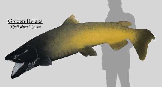
Salmonids of Artechocene Antarctica:
While thawing, the glaciers of Antarctica created an abundance of meltwater streams that now feed countless kilometres of freshwater ecosystems. At first nothing more than insect larvae and some crustaceans called these new environments home, but eventually fish entered the equation and quickly dominated.
One group of these fish were salmonids coming from South American coasts, descendants of invasive species such as the brown trout. They weren't the first, but they were much better at filling a lot of niches than the native Nothotenioids, which lacked hemoglobin and swim bladders.
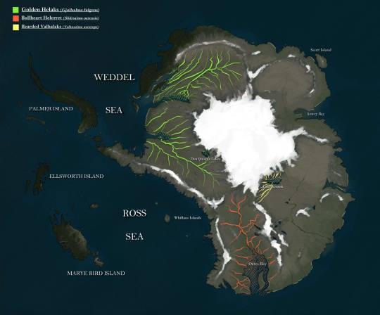
And so they almost outcompeted these to extinction, and diversified into several genera classified roughly in three distinct groups: Helaks, Helerrets, and Valhallaks.

Most of the Helaks species are amongst the largest predators of the continent, and the Golden Helaks (Gjollsalmo fulgens) is the largest of them all, measuring up to 2 meters (7ft) long and more than 100kg (250lb) in weight. They're apex predators, using their size to block scape routes for prey fish of any size and swallowing them whole, preventing them from scaping thanks to its huge backwards facing teeth. They're also known to eat crustaceans and even birds that venture too deep into the water. They live in every waterway across Antarctica, with the adults being confined to the deeper canals and lakes.
Helerrets are the most common salmonids that can be found in the rivers, lakes and wetlands of the continent. These medium sized predators mainly feed on the abundance of mollusks and other hard shelled invertebrates, as well as smaller vertebrates occasionally. This diet is enabled by their strong jaws, combined with blunt teeth that can crack open the shells of most freshwater invertebrates in their habitats. They're also the only Antarctic salmonids that retain the anadromous habits of its ancestors, living in freshwater but migrating to coastal waters to reproduce and release their young into the rich waters of the Southern Ocean.
The Bullheart Helerret (Slidrsalmo oatensis) in particular is native to the drainage basins that flow into Oates bay, where members of this species comes to spawn.

Valhallaks are a group of salmonids with remarkable sexual dimorphism compared to their close relatives. They are typically found in shallow rivers all across the continent, where they feed on invertebrates and vegetation.
Although not as common as Helerrets, they are abundant, specially in alpine streams and lakes during the end of the summer, where they come to spawn, away from predators so their eggs are protected by ice during the winter.
The Bearded Valhallaks (Valholsalmo auratops) specifically is endemic to the Vostok river drainage basin, which originates in Vostok Lake where they reproduce.
Range of the species featured:

88 notes
·
View notes
Text


Idaho Falls, ID (No. 4)
As soon as the railroad came through, settlers began homesteading the upper Snake River Valley in earnest. The first new settlers carved out homesteads to the north at Egin (near present-day Parker) and at Pooles Island (near present-day Menan). The Utah & Northern Railway provided easy access, especially to homesteaders from Utah, who soon populated much of the area surrounding Eagle Rock. Some of these men had initially worked building the railroad, then later returned with their families to stake out new farms. These Utah families brought irrigation know-how developed in Utah's Great Basin settlements. Through their and others' canal systems, water from the Snake River made the Upper Snake River Valley into one of the most successful irrigation projects in the Mountain West. Large-scale settlement ensued and within a decade, there appeared roads, bridges, and dams, which brought most of the Upper Snake River Valley under cultivation.
Then, in 1887, following the construction of the Oregon Short Line and a railroad workers' strike in Eagle Rock, most of the railroad facilities were moved to Pocatello, where the new line branched off the U&NR. This caused a sharp and immediate drop in population, which nearly killed the town. In 1891, marketers convinced town leaders to change the name to Idaho Falls in reference to the rapids below the bridge. Some years later, the construction of a retaining wall for a hydroelectric power plant transformed the rapids into waterfalls. On June 22, 1895, the world's then-largest irrigation canal, the Great Feeder (located 5 miles northeast of Ririe), began diverting water from the Snake River, helping to convert tens of thousands of more acres of desert into green farmland. The area grew sugar beets, potatoes, peas, grains, and alfalfa, and became one of the most productive agricultural regions of the United States. The city once again began to flourish, growing continuously into the 20th century.
Source: Wikipedia
#Idaho Falls#Idaho#Bonneville County#Snake River#evening light#river walk trail#travel#original photography#vacation#tourist attraction#landmark#cityscape#architecture#public art#USA#summer 2024#river bank#nature#flora#lawn#pedestrian bridge#shadow#Idaho Falls River Walk#Greenbelt Trail
3 notes
·
View notes
Text
Terence McKenna gave a talk at a 1993 UFO convention, where he discussed his personal encounter with a UFO. He had previously written about this encounter in his book "True Hallucinations", which recounts his adventures and experiences in the Amazon Basin during the 1970s. The talk was given to an audience largely unfamiliar with McKenna's work, so he shared his thoughts on UFOs, aliens, and their potential connection to psychedelic experiences. He posited that some psychedelic substances serve as gateways to the collective unconscious and facilitate encounters with alien-like entities, linking the personal psychedelic journey to broader cosmic and evolutionary narratives. This idea blends Jungian psychology with shamanic and esoteric traditions, framing UFO encounters as symbolic representations of deeper psychological truths or potential glimpses into alternate realities.
Terence McKenna: UFO - The Inside Outsider (1993)
youtube
In this talk, given at an ethnobotanical conference in Palenque, Mexico, McKenna discusses the idea of humanity entering a new phase of existence. In McKenna's view, the evolution of human communication and creativity was not just a biological process, but also a spiritual and consciousness-expanding journey. He saw the development of language and symbolic thinking as key factors in humanity's ability to perceive and interact with the Gaian Mind, ultimately shaping our understanding of reality and our place within it. He envisioned a world where human activities, including scientific and technological development, would be guided by a deep connection to the Gaian Mind rather than by capitalist imperatives. He used the metaphor of birth to describe this transition, comparing our current state to being in the birth canal of a new ontological order.
Terence McKenna: New Phase of Human Existence (1994)
youtube
Wednesday, July 3, 2024
6 notes
·
View notes
Text


This is not simply or strictly a gangster cool, though ever since Peter Weir’s The Year of Living Dangerously, and again with the 2012 documentary The Act of Killing, Jakarta has loomed in the Western cultural imaginary as a tropical noir, an urban heart of darkness. Joseph Conrad actually did write a 1915 novel set on Java, called Victory: An Island Tale, and, in tandem with the Dutch classic of political awakening, Max Havelaar, anonymously penned in 1860, it portrays Indonesia as the Asian colony in extremis. Much like the films, both novels are rife with complex cultural misunderstandings, moments of startling clarity, and undercurrents of unfathomable cruelty. Yet none of these works delves much into the spatial character of Batavia, old or new. In contemporary culture Jakarta registers now as a vague haven of criminal reinvention (see Blackhat, by Michael Mann), just as Los Angeles did for much of its history, bathed in the seductive shadows of ill repute. In both cities, though, one finds as much sunshine as noir — and in Jakarta far more day-to-day consideration than corruption.
Abetting their outlaw casting, Jakarta and Los Angeles are both cities of systems, rather than boundaries. Indeed, Jakarta is shaped by the same two dynamic forces as Los Angeles, and their corollary infrastructures: waterflow, though measured in deluge rather than drought; and traffic, though more constant and intense here than in L.A. Either an excess or scarcity of water requires intensive hydro-systemic management, so both cities are coursed by many canals running from their highlands down-basin to their harbors. Too big to bury but too meager to provide riverfront causeways or esplanades, the many concretized and cordoned “creeks” of both cities form a kind of urban subconscious in plain view, reminders of how nature was bought off early, but not forever, by the Dutch East India Company or the U.S. Army Corps of Engineers.
31 notes
·
View notes
Text
As France grapples with soaring temperatures and ever more ruinous droughts, a full-blown water war is unfolding in the country, with heavy clashes, injuries, and arrests.
Tensions are running high over the use of giant artificial reservoirs for irrigation, which some farmers rely on to cope with water scarcity but which critics say are making the problem worse, accelerating the depletion of limited groundwater resources for the benefit of only a handful of big producers.
It’s one of many conflicts over water access breaking out with growing frequency all over the world, as climate change dries soils, increases temperatures and makes crops thirstier, and reduces the annual snowpacks that traditionally replenished freshwater flows. Water diversion in China is stoking regional ire. In Central Asia, access to scarce water resources is exacerbating cross-border tensions. Climate change and upstream dams, as well as poor water management, are drying out Iraq and Iran. Egypt and Ethiopia have been at odds for years over an upstream Nile River dam that threatens downstream countries. Western U.S. states are bickering over the dwindling resources of the once-mighty Colorado River, while in Germany and Chile, contentious access to water is fueling domestic strife.
“Water is a common good. No one can claim it as their own,” said Julien Le Guet, a spokesperson for Bassines Non Merci (Basins No Thanks), an activist group. This month, Le Guet and several other defendants went on trial over various unauthorized demonstrations against the construction of a new mega-reservoir in Sainte-Soline, in western France.
A rally held in March, in particular, turned into a violent confrontation with the police that left 47 officers and 200 demonstrators wounded. Some local farmers also denounced damage to their crops and the pipes linking their fields to the new basin. Fresh protests took place at another construction site nearby and in Paris over the last few weeks, with more actions planned in the near future.
Estimates vary between 100 and several hundred retention basins in France, giant plastic-lined craters spanning 20 acres on average that are filled by pumping groundwater in winter for use during the scalding summer months. And their number, whatever it is, is growing. The project in the Deux-Sèvres region (which includes Sainte-Soline), led by a private cooperative of local farmers, entails the construction of 16 new reservoirs that would store more than 6 million cubic meters of water—the equivalent of 1,600 Olympic swimming pools. Another 30 reservoirs are due to be built in the nearby Vienne region.
Supporters say that as the weather gets hotter and drier—2023 had the hottest summer on record globally—the basins are an indispensable life insurance for farmers and a way to reduce the pressure on water resources when they are at their lowest. France has recently been experiencing its worst droughts ever; in July, more than two-thirds of its natural groundwater reserves were below normal levels.
“Irrigating without basins means to continue pumping groundwater, even when there’s less of it,” said Laurent Devaux of Coordination Rurale, a farmers’ union.
The problem, critics say, is that the reservoirs are siphoning precious groundwater for the benefit of a small minority. Just 7 percent of French farmland is equipped with irrigation canals, and only some of the irrigated farms around the reservoirs are actually connected to them. The basin in Sainte-Soline will be directly linked to barely 12 farms out of a total of 185 in the area. According to Le Guet, of all the irrigated farms in the region concerned by the Deux-Sèvres project, the ones that will be connected to the new basins use twice as much water on average as the others.
“This is not just a conflict between certain farmers and environmentalist groups,” said Laurence Marandola, a spokesperson for the Confédération Paysanne farmers’ union, which opposes the basins. “All of us farmers need water,” she said.
And there is less and less of it. Due to the combined effects of global warming and over-pumping, Europe’s groundwater resources have been steadily declining in recent decades, with a yearly loss of some 84 gigatons of water (roughly the equivalent of Lake Ontario) since the turn of the century—just like what’s happening elsewhere in the world, from much of the U.S. to the Middle East.
Critics, including conservationists, small farmers, and scientists, slam the reservoirs as a particularly wasteful method of storing water. Keeping it out in the open, rather than underground, means that some of it evaporates and the remaining part heats up, filling with toxic bacteria, said Christian Amblard, an honorary research director at France’s National Center for Scientific Research. “You’ve got, at the same time, a loss of quantity and quality. It makes no sense,” he said.
Finally, these reservoirs are accused of perpetuating what critics call an unsustainable agricultural model that consumes too much water and accelerates global warming. More than 60 percent of Europe’s arable land is used to feed livestock—which, globally, is responsible for over 30 percent of the world’s emissions of methane—a powerful greenhouse gas. The crops that are grown for animal feed include corn, which occupies one-third of all irrigated land in France and demands lots of water in the summer—hence the need for solutions such as the reservoirs.
“The mega-basins are delaying a transition to a responsible, resilient, and water-efficient agriculture,” Amblard said.
That transition would entail, among other things, working to make soils more capable of retaining water and pivoting away from meat and dairy production, according to experts. With up to 15 billion euros in public aid doled out to the French agriculture sector every year, the necessary financial resources shouldn’t be hard to find, Amblard said. “The agricultural sector is one of the few where the ecological transition can be carried out without leaving anyone by the wayside,” he said.
So far, though, successive French governments have shown little appetite for that, handsomely subsidizing the reservoirs instead—which current French Agriculture Minister Marc Fesneau praised as “virtuous.” Taxpayers will foot 70 percent of the 76-million-euro bill for the ones planned in the Deux-Sèvres. If farmers have an outsized political and financial influence in the European Union as a whole, in France they are a political power unto themselves.
French authorities have also been cracking down hard on the anti-basins movement. Police have come under heavy criticism for their handling of the Sainte-Soline protest, with the Human Rights League, a French nongovernmental organization, denouncing the indiscriminate firing of rubber bullets and the hindering of first-aid workers by the security forces in a bid to “prevent access to the basin’s site, whatever the human cost.”
French Interior Minister Gérald Darmanin has described some of those taking part in the protests as “eco-terrorists” and has taken steps to dissolve Les Soulèvements de la Terre (Earth’s Uprisings), a vocal, and sometimes violent, environmental group.
“We are increasingly the target of legal actions, investigations, and surveillance,” Le Guet said. “Over the last year, court summons have been raining down,” he said, adding that the movement will continue to hamper new basin construction, nonetheless.
The debate looming in France is a familiar one from the American West to the headwaters of the Nile. The basins “are being politicized and isolated from their context, with the farmers who back them being unfairly designated as villains,” Devaux said.
But “there simply isn’t enough water in the underground reserves to carry on like this, extracting these amounts of water for agriculture,” Marandola said. “And what is done with the water that’s taken should be decided in a democratic way, for every single drop.”
11 notes
·
View notes
Text
Port Jervis, New York - A Historic Canal and Railroad Transport Hub

With roots as a pre-automobile transportation hub, Port Jervis, New York, is a historic burgh with a history of colonial settlement extending to the 1690s. Northeast of New York City, it’s situated amidst the fertile valleys of the Delaware and Neversink River systems. The valleys mark the boundary between the Appalachian Plateau and Shawangunk Mountains, and hundreds of miles of state and nationally-managed recreational lands surround it.
Initially known as Carpenter’s Point, Port Jervis was a landing point for timber raftsmen who plied the upper Delaware River. It was also a stop on the Old Mine Road, the country’s first 100-mile road (now United States Route 209), which took travelers south from Kingston.
Carpenter’s Point was incorporated into Deerpark in 1798. The locale was named Port Jervis in 1827, and it officially became a port of the Delaware River and Hudson Canal in 1828. As a repair point and boat basin, it formed an essential station on a 171-mile-long transportation network that brought anthracite coal from Pennsylvania’s northeastern mountains to New England and New York City. The name was in honor of the Hudson Canal’s chief engineer, John B. Jervis, from Rome, New York.
In 1847, Port Jervis became a hub for railroad operations and grew to house a main engine terminal facility while serving as the Delaware Division of the Erie Railroad’s headquarters. This property included the railroad’s primary maintenance and yard facilities.
Port Jervis officially became a village in 1853 and ultimately incorporated as a city in 1907. In the late 19th century, several glass factories began business, and an influx of employees producing glassware, silk, gloves, shorts, mittens, and saws moved in. The railroad yards and light manufacturing shops were a major part of the local economy through the 1960s.
Today, tourism is the mainstay of Port Jervis, with historic Front Street featuring eateries, a bookshop, antique shops, and other small businesses. The well-marked Delaware River Heritage Trail provides a walking tour of various gardens, historical structures, and an exceptional view of the Delaware River.
Among the well-preserved sites worth exploring is Fort Decker, a stone house on West Main Street that was initially constructed in 1760 and burnt by Joseph Brant alongside Native American allies in a 1779 raid during the Revolutionary War. Serving as the Minisink Valley Historical Society museum, Martinus Decker rebuilt the house in 1793 and used it as a tavern and hotel during the years of the Delaware and Hudson Canal construction. Indeed, John B. Jervis stayed at the location while engineering the canal.
Another historic remnant is the Port Jervis turntable, which comprises a circular area with a 115-foot diameter and a bridge. Able to carry a weight of more than 440 tons or a locomotive loaded with coal and water, the turntable is the largest that still operates nationwide.
Befitting its status as a scenic tourist destination, Port Jervis offers several popular events each year, including the Fall Foliage Festival, for which volunteers place 50 corn stalks on light poles decorating Pike and Front Streets. There are also popular holiday events such as the Downtown Spooktacular and the Chriskindlmarkt, with the latter featuring horse and carriage rides and traditional juggling as entertainment.
3 notes
·
View notes
Text
New Canal, 1864
Many locals say “New Basin Canal,” but the Coast Guard just calls it the “New Canal.” The New Canal in 1864 Photograph of the turning basin for the “New Canal,” located at S. Rampart Street and Howard Avenue. Construction of the canal began in 1831. In spite of the original intent of city planners, there never was a canal built on Canal Street. Instead, the Creole community living in the Vieux…
0 notes
Text
Uhh lemme see what I remember
The great lakes, going upstream to downstream, are Superior, Michigan (does Superior actually flow into it or is it a branch?), Huron, Erie, and Ontario
There are several other lakes in the system that are pretty darn big by lake standards but aren't counted as Great Lakes because they're so enormous by comparison. Lake St. Clair between Huron and Erie is one of them, I think there are a couple other significant ones that flow into Lake Superior or something.
Lake Superior is the largest freshwater lake by area in the world (though not by volume, that would be Lake Baikal), unless you count Michigan and Huron as one lake because there's a strait between them and not a river, in which case they'd be the biggest.
Niagara Falls is somewhere between Erie and Ontario.
We share all of them except Lake Michigan with Canada.
There's a famous canal called the Erie Canal that I assume connects Lake Erie and... some river or lake in upstate new york? I know the song goes "From Albany to Buffalo."
In winter prevailing winds from the west pick up moisture off the warm lake water and create "lake effect snow" when they hit land south and east of the lakes, which makes places like Ohio and Upstate NY have very snowy winters.
Their outflow is the St Lawrence river which is a major navigational channel in Canada and... is that river the border between the US and Canada at any point or does it just go north into Canada?
Can you get a boat/ship from the ocean all the way to Lake Superior via canals or is Niagara Falls in the way?
The Great Lakes are only the latest in a long series of different lakes that have occupied the basin over the course of glacial and interglacial cycles during the current ice age, and IIRC the basin is sitting on top of an extremely ancient failed rift in the North American Craton from over a billion years ago.
Lake Huron has the largest island in a lake in the world, which contains the largest lake on an island in a lake. I think at higher levels of recursion some lakes in northern Canada take the record.
Do other USAmericans not know the names of the Great Lakes?? I grew up in the midwest so like. They're important here but I never considered that other people might not give a fuck about these terrifying inland seas until I was reading a fic that said "the large Lake Michigan and another called Lake Erie" as if there are people who don't know about Lake Michigan and Lake Erie.
Is that the case?? Are people outside of the midwest aware of these bodies of water outside of being just big lakes???
19K notes
·
View notes
Text
Will We Have to Pump the Great Lakes to California to Feed the Nation? (New York Times)
Coast to coast, our food producing regions, especially those stretching from the southern Great Plains across the sunny, dry Southwest, rely heavily and sometimes exclusively on groundwater for irrigation. And it’s disappearing — fast.
What happens to the nation’s food production if the groundwater runs out altogether? Unless we act now, we could soon reach a point where water must be piped from the wetter parts of the country, such as the Great Lakes, to drier, sunnier regions where the bulk of the nation’s food is produced. No one wants unsightly pipelines snaking across the country, draining Lake Michigan to feed the citrus groves of the Central Valley. But that future is drawing closer by the day, and at some point, we may look back on this moment and wish we’d acted differently.
For over a century, America’s farmers have overpumped groundwater, and now, as the world warms and the Southwest becomes drier, the situation is only growing more dire. Rivers are slowing to a trickle, water tables are falling, land is sinking, and wells are drying up. Each year, roughly 25,000 more farmers fallow their fields, putting both food and water security in the United States at risk.
States are aware there is a problem — many are trying to sustainably manage their groundwater. But it’s not clear how successful these efforts have been. My research team has found that groundwater depletion is accelerating in the Central Valley, in spite of California’s Sustainable Groundwater Management Act. In Arizona, groundwater is only managed in less than 20 percent of the state, leaving a free-for-all in the state’s unmanaged areas.
The United States has no plan for the disruptions that will befall our food systems as critical water supplies dwindle, causing the price of some foods to skyrocket and bringing us closer to the time when we may have to consider pipelines to replenish or replace depleted groundwater.
Americans, particularly those living in places like the Great Lakes region, have already shown that they have little stomach for infrastructure projects that would move their local water to remote locations, even if it is to produce the food they eat every day.
It’s not just the political climate that makes tapping water resources in the East such an undesirable prospect. We’ve built systems of canals to move water around California and the Colorado River basin, but constructing a transcontinental pipeline or river diversion, at the scale required to sustain U.S. agriculture, would be staggeringly more complex, expensive and environmentally disruptive.
They would require significant landscape changes and human displacement. And because water is so heavy, it is extremely expensive to transport. Building the necessary conveyances would require decades of planning, have major environmental consequences and cost taxpayers astronomical sums — easily tens to hundreds of billions of dollars, and far more when you take the human and environmental costs into account.
5 notes
·
View notes
Text
Novorossian Empire
From the Imperial Chronicler's Records
GEOGRAPHY & TERRITORIES
NATURAL FEATURES
Vast northern steppes
Dense taiga forests
Frozen tundra
Major river networks
Mineral-rich mountains
Coastal fjords
Fertile southern plains
Natural harbors


NOTABLE TERRITORIES
Whispering Woods (haunted forest)
Thunder Plains (storm-wracked steppes)
Frost's Edge (northern frontier)
Imperial Highway (ancient trade route)
Mammoth's Rest (prehistoric grounds)
Echo Valley (mysterious acoustics)
Crystal Lakes (frozen year-round)
Giant's Steps (megalithic ruins)
Lost Legion Pass (military graveyard)
Steam Devil's Basin (geothermal field)


SETTLEMENTS
PETROGRAD (Capital)
Canal-crossed metropolis
Winter Palace Complex
Grand Cathedral of Progress
Steam Works District
Telegraph Tower
Noble's Quarter
Merchant's Ring
Military Academy
Opera District
Worker's Ward


KEY SETTLEMENTS
Steelheart (industrial center)
Port Aurora (northern harbor)
Academy City (education hub)
Fort Resilience (military base)
New Prosperity (trade center)
Clockwork Keep (research facility)
Engineer's Rest (invention hub)
Soldier's Peace (veteran town)
Unity Square (cultural melting pot)
Progress Point (technology showcase)


SOCIETY & GOVERNANCE
DEMOGRAPHICS
Humans (vast majority)
Northern Giants (integrated)
Frost Elves (diplomatic allies)
Steam Gnomes (tech specialists)
High education emphasis
Class-based hierarchy
Military service paths
POWER STRUCTURE
Constitutional monarchy
Military council
Noble houses
Duma (parliament)
Industrial magnates
Veteran associations
CULTURAL VALUES
Technological progress
Military discipline
Class distinction
Imperial loyalty
Scientific advancement
Traditional arts
Winter festivals
Victory celebrations
Veteran honors
Innovation worship


TECHNOLOGY & INDUSTRY
INNOVATIONS
Steam-powered machinery
Telegraph networks
Industrial factories
Military equipment
Railway systems
Canal engineering
Weather prediction
Agricultural tools
CURRENT TENSIONS
Reform vs tradition
Military vs parliament
Noble vs merchant class
Technology vs nature
Expansion vs consolidation
Veterans' rights movement


ECONOMY
Military production
Heavy industry
Railway transport
Telegraph services
Agricultural exports
Technical education
Banking systems
MILITARY
Steam-powered artillery
Elite frost troops
Railway corps
Telegraph specialists
Northern giant units
Winter warfare experts
Naval ice-breakers
#virtual friend#virtual companion#AI companion#AI chatbot#AI art#Enchanted Legacy#Novorossian Empire#magical adventure#adventure fantasy#dark fantasy#epic fantasy#historical fantasy#fantasy world#fantasy worldbuilding#fantasy lore#enchanted forest#mythical creatures#steampunk magic#masterlist
0 notes
Text

You heard it first here.
Oil companies and western politicians planning a replacement for the Suez Canal, going on the eastern side of the Sinai Peninsula, terminating in Gaza and connecting to an offshore development of the Western Mediterranean Oil Basin and complex of onshore oil refineries benefiting Israel and its partners in crime.
We've known about the Western Mediterranean Oil Basin for decades, but development has been delayed in deference to Saudi Arabia and the rest of the Oil Emirates. Now, the Suez Canal is old and suffering multiple infrastructure issues, so the gaze of the crazed plutocrats has naturally turned toward what else can they grab that isn't theirs?
Oh, a blivet ton of oil ripe for the taking and a whole new canal and refinery development opportunity allowing the western powers to again dominate not only European oil and gas markets, but also plonk all of Eastern Africa, the Indian Ocean Basin, heck, why not Southeast Asia?
It's a no-brainer, except for those pesky Palestinians peacefully living their lives on the Gaza Strip.
So these criminal corporations brewed up their own little False Flag, paid off Hamas, an organization that they created, and after months of saturation carpet bombing by Israel, oh, look, what have they got?
A "humanitarian crisis" that has gone to seed.
Big bad Israel has destroyed the Gaza Strip. They've made it uninhabitable. The schools, hospitals, water, sanitation, and electrical facilities are all gone. The roads are in shambles. The houses, the neighborhoods, everything, gone. Most of the people are dead and survivors are dislocated.
Enter Donald Trump.
Isn't the answer obvious? Relocate the refugees to Egypt and Jordan, take over the land and don't pay anyone for it, let Israel claim it and ta-da! Yet another "victory" for criminal western technocrats, criminal western oil companies, criminal western colonial interests, criminal British Crown Corporations, all the usual criminals having a CrimeFest together.
Don't believe it? Listen:
youtube
The destruction of Gaza is a premeditated crime and the motive is money. Just like the same parties have used weather warfare in North Carolina, planning to steal the ruined land for pennies on a dollar, and mine all the rich lithium deposits and other Rare Earth minerals out of the Southern Appalachians. Los Angeles? To be turned into one giant water and air cargo hub serving the entire Pacific Rim, and more oil refineries, of course, to develop the Eastern Rockies Reservoir.
They aren't just going to drill, baby, drill, they are going to gush.
Oil and gas will be so plentiful and so cheap that nobody will even think about developing free energy for another hundred years.
As usual, too, these bullies targeted the poorest of the poor, depriving, defrauding, and destroying --- then pretending that they had nothing to do with it, and that they are going to "help" their victims by resettling them and building new housing, generously using our credit and assets to do it, and charging us for this "service" we never authorized.
The banks and the bankers supporting this need to be prosecuted and so do the corporations involved. They all need to be shut down, and made to pay for the misery and destruction their greed has caused. Until these criminals are brought under control there will be no end to their meddling, violence, and rapacious theft of resources.


#blacklivesmatter#blackvotersmatters#donald trump#joe biden#naacp#blackmediamatters#blackvotersmatter#news#ados#youtube
1 note
·
View note
Text
our father who art in heaven
stay there
and we'll stay here on earth
which is sometimes so pretty
with its mysteries of new york
and its mysteries of paris
at least as good as that of the trinity
with its little canal at ourcq
its great wall of china
its river at morlaix
its candy canes
with its pacific ocean
and its two basins in the tuileries
with its good children and bad people
with all the wonders of the world
which are here
simply on the earth
offered to everyone
strewn about
wondering at the wonder of themselves
and daring not avow it
as a naked pretty girl dares not show herself
with the world's outrageous misfortunes
which are legion
with legionaries
with torturers
with the masters of this world
the masters with their priests their traitors and their troops
with the seasons
with the years
with the pretty girls and with the old bastards
with the straw of misery rotting in the steel of cannons.
Jacques Prévert
0 notes