#multispectral imaging
Explore tagged Tumblr posts
Visit Tumblr Blog
Explore Tumblr blogs with no restrictions, modern design and the best experience.
Last Seen Tumblr Blogs


Fun Fact
Tumblr has a low social media market share in South America.
Text
Palimpsest Discovered in Recently Acquired Roll

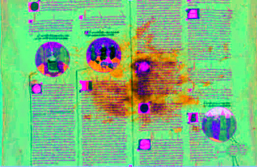
Roll before and after multispectral imaging. The poem is visible under the stain in the middle of the photo.
Exciting new discoveries are always possible in the world of manuscript studies, but even we were unprepared for what emerged from Penn’s latest acquisition. Recently, the Library purchased a fragment of a Genealogy of Christ roll—an important addition to our collection. “But upon close examination,” explains SIMS Curator of Digital Humanities Dot Porter, “it became clear that the parchment had been reused; an earlier text was erased, and new text was written over. It’s a palimpsest.”
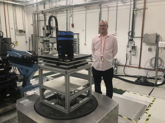
Enter Multispectral Imaging, conducted by Dr. Helen Davies, assistant professor of the digital humanities in the English department and co-director of the Center for the Digital Humanities at the University of Colorado Colorado Springs.

Helen Davies imaging the roll
Dr. Davies described the process: “I imaged the roll using multispectral imaging, and as the data was processed, words began to emerge.”
And not just any words.
Amey Hutchens, University of Pennsylvania Libraries Manuscripts Cataloger, has confirmed that the undertext is an entirely unknown poem, strikingly similar in style and theme to the works of the enigmatic classical lyricist Ricardus Astleaus.
“Could this be a lost work of the poet himself?” Schoenberg Curator of Manuscripts Nicholas Herman voices the question we’re all asking. “The implications are staggering.”
We welcome input from the scholarly community, who can read a transcription of the poem “Tete Numquam Relinquam” here.
495 notes
·
View notes
Text
Episode 20: Paul Dilley on Papyrus, Manichaeism, and Multispectral Imaging

A photo of a page from one of the Medinet Madi Coptic Manichaean Codices taken under ultraviolet light.
In Episode 20 of Inside My Favorite Manuscript, Dot talks with Paul Dilley about one of the Medinet Madi Coptic Manichaean Codices. These seven papyrus manuscripts dating to the 4th and 5th centuries were discovered in Egypt in 1929, and they tell the story of a religion that was intended to draw from Christianity, Buddhism, Gnosticism, and other religions to create something new, but it was later crushed by Christian Roman emperors who considered it heresy. Our conversation ranges from the conservation of papyrus and the details of the beliefs of Manichaeism, to papyrus conservation and multispectral imaging.
Listen here, or wherever you find your podcasts
Below the cut are more images and links relevant to the conversation. Please note that there is an animated gif that switches between light and dark at one second intervals. Please be careful if you are sensitive to flashing lights.
These manuscripts have been minimally digitized, so we don't have many images to show.
The papyrus is quite damaged, and the text is so faded it can be difficult to read.
Multispectral imaging can help clarify the ink.

And here is a little animated gif that illustrates the difference between the two photos.
And finally, the photo of Paul ready to put the manuscript through the machine!
Dr Brent Seales, "Reading the Invisible Library: Virtual Unwrapping and the Scroll from En-Gedi" (Video on YouTube, February 2023)
#manuscript#coptic#manichaeism#ancient history#ancient religion#papyrus#4th century#5th century#multispectral#multispectral imaging#podcast#inside my favorite manuscript#imfmpod#imfm
6 notes
·
View notes
Text


on the left a palimpsest I found, on the right just some guy chilling
ms. Trivulziano 1084 & the Hereford map (facsimile)
#after two weeks of sort of learning how to take multispectral images of manuscripts#and then sort of learning how to modify them to make the scriptio inferior come out#with results like these I feel like I can do anything#I'm just.. amazed at how things that are invisible to the naked eyes can now be seen#btw you can see how the Humanities are so underfunded we don't even have desks#personal#university things#summer school#manuscript#medieval manuscripts
16 notes
·
View notes
Text
Harnessing the Power of Hyperspectral Imaging in Agriculture
The field of hyperspectral imaging in agriculture is making significant strides, offering a wide range of benefits to the industry. Space technologies play a pivotal role in providing extensive coverage and with the application of hyperspectral imaging, offer crucial and granular insightsfor overall agricultural productivity.
This article discusses how this technology presents a valuable solution to tackle critical challenges faced by agricultural businesses, including crop health monitoring, yield improvement, pest detection, and nutrient content assessment.
Optimizing Crop Management and Yield Enhancement:
The agricultural sector faces several challenges regarding crop management and yield estimation and optimisation, while coping with a growing global population and declining natural resources. Traditional approaches to assessing crop and soil health are often labor-intensive, time-consuming, and lack accuracy, resulting in decreased productivity and adverse environmental impacts.
Hyperspectral Imaging utilizes its ability to capture a wide range of spectral bands to provide accurate and real-time information about the biochemical composition and health of crops. By providing precise information about variations in crop growth, nutrient imbalances, soil conditions, and early warnings for pest infestations and crop diseases, hyperspectral imaging empowers farmers and agronomists to make informed decisions and take timely actions.
Precise Weed Control and Nutrient Optimization:
One notable application of hyperspectral imaging is its ability to differentiate between crop species and weeds, facilitating targeted weed control measures, and reducing herbicide usage. By analyzing field-level details, farmers can observe changes in crop health and promptly address any issues.
Hyperspectral imaging also aids in monitoring nutrient content, pinpointing specific imbalances in plants or soil, enabling precise fertilization strategies, minimizing waste, and optimizing nutrient uptake.
Efficient Water Management, Effluent Monitoring, and Resource Conservation
Water scarcity and efficient water management, including effluent monitoring, are critical points of concern in modern agriculture. To address these challenges, hyperspectral imaging technology offers valuable insights and tools for optimizing water usage in agricultural systems.
By utilizing advanced sensors capable of capturing a wide range of electromagnetic wavelengths, hyperspectral imaging enables detailed monitoring of crop water stress, soil moisture levels, and irrigation needs. This capability enables farmers and agronomists to make data-driven decisions regarding irrigation scheduling, ensuring that water is applied precisely where and when it is needed.
By accurately assessing plant water status and optimizing irrigation practices, hyperspectral imaging helps conserve water resources, improve water use efficiency, and enhance crop productivity. Additionally, by integrating hyperspectral imaging data with other relevant parameters such as weather patterns and crop growth stages, farmers can develop predictive models and decision support systems for proactive water management, effluent monitoring, and resource conservation.
This holistic approach to water management empowers farmers to achieve sustainable agricultural practices, reduce water waste, and mitigate the impacts of water scarcity on crop production.
Early Disease Detection and Field Margin Monitoring:
Hyperspectral imaging contributes to early disease detection by analyzing the unique spectral signatures of crops, allowing farmers to proactively mitigate their spread and minimize crop losses. Additionally, hyperspectral imaging supports field margin monitoring, by providing valuable insights to assess and manage the health and biodiversity of these critical areas.
Furthermore, hyperspectral imaging assists in effluent monitoring, tracking, and managing agricultural waste and its environmental impact.
Precision Agriculture: Optimizing Crop Health and Variety Selection
In the realm of precision agriculture, hyperspectral imaging presents itself as a powerful tool for enhancing vegetation stress assessment and crop classification. By capturing data on stressors like water scarcity, nutrient imbalances, and pest infestations, hyperspectral imaging offers valuable insights into the overall health of crops. Armed with this information, farmers can proactively implement targeted mitigation measures to ensure optimal productivity.
Furthermore, the high spectral resolution of hyperspectral imaging enables accurate classification of different crop varieties based on spectral data analysis. This capability empowers farmers to effectively manage their fields, selecting the most suitable crop varieties for specific environmental conditions. By harnessing the precision of hyperspectral imaging, farmers can further optimize their operations, promote crop health, and maximize yields in the realm of precision agriculture.
Hyperspectral imaging is capable of addressing key challenges and providing valuable insights for efficient crop management. Embracing the potential of hyperspectral imaging is a vital choice for the agricultural industry to unlock its full range of benefits, leading to enhanced yields, improved pest detection, optimized nutrient assessment, efficient soil health evaluation, accurate disease detection, meticulous field margin monitoring, and informed pasture and herbal ley management.
As the agricultural sector continually seeks innovative and sustainable practices, hyperspectral imaging paves the way for a more productive and environmentally conscious future across the field.
#Hyperspectral Imaging#agtech#agritech#agriculture#farming#multispectral#satellite imagery#satellite#remote sensing
2 notes
·
View notes
Text
EnMAP (Environmental #Mapping and #Analysis Program) is a German satellite for the simultaneous #acquisition of high-resolution, hyperspectral images in the visible and near #infrared range
1 note
·
View note
Text
Child's Sock from Egypt, c.250-350 CE: this colorful sock is nearly 1,700 years old

This sock was discovered during excavations in the ancient city of Oxyrhynchus. It was likely created for a child during the late Roman period, c.250-350 CE.
Similar-looking socks from late antiquity and the early Byzantine period have also been found at several other sites throughout Egypt; these socks often have colorful, striped patterns with divided toes, and they were crafted out of wool using a technique known as nålbinding.

Above: a similar child's sock from Antinoöpolis, in Egypt, c.250-350 CE
The sock depicted above was created during the same period, and it was found in a midden heap (an ancient rubbish pit) in the city of Antinoöpolis. A multispectral imaging analysis of this sock yielded some interesting results back in 2018, as this article explains:
... analysis revealed that the sock contained seven hues of wool yarn woven together in a meticulous, stripy pattern. Just three natural, plant-based dyes—madder roots for red, woad leaves for blue and weld flowers for yellow—were used to create the different color combinations featured on the sock, according to Joanne Dyer, lead author of the study.
In the paper, she and her co-authors explain that the imaging technique also revealed how the colors were mixed to create hues of green, purple and orange: In some cases, fibers of different colors were spun together; in others, individual yarns went through multiple dye baths.
Such intricacy is pretty impressive, considering that the ancient sock is both “tiny” and “fragile."
Given its size and orientation, the researchers believe it may have been worn on a child’s left foot.

Above: child's sock from Al Fayyum, Egypt, c.300-500 CE
The ancient Egyptians employed a single-needle looping technique, often referred to as nålbindning, to create their socks. Notably, the approach could be used to separate the big toe and four other toes in the sock—which just may have given life to the ever-controversial socks-and-sandals trend.
Sources & More Info:
Manchester Museum: Child's Sock from Oxyrhynchus
British Museum: Sock from Antinoupolis
Royal Ontario Museum: Sock from Al Fayyum
Smithsonian Magazine: 1,700-Year-Old Sock Spins Yarn About Ancient Egyptian Fashion
The Guardian: Imaging Tool Unravels Secrets of Child's Sock from Ancient Egypt
PLOS ONE Journal: A Multispectral Imaging Approach Integrated into the Study of Late Antique Textiles from Egypt
National Museums Scotland: The Lost Sock
#archaeology#artifact#history#anthropology#child's sock#ancient textiles#ancient egypt#roman egypt#fabric arts#knitting#fashion#naalebinding#art#classical antiquity#children in archaeology#natural dyes#wool#yarn#ancient clothing#children#roman#sewing#egyptology#cute little stripy socks
2K notes
·
View notes
Text
"The first satellite in a constellation designed specifically to locate wildfires early and precisely anywhere on the planet has now reached Earth's orbit, and it could forever change how we tackle unplanned infernos.
The FireSat constellation, which will consist of more than 50 satellites when it goes live, is the first of its kind that's purpose-built to detect and track fires. It's an initiative launched by nonprofit Earth Fire Alliance, which includes Google and Silicon Valley-based space services startup Muon Space as partners, among others.
According to Google, current satellite systems rely on low-resolution imagery and cover a particular area only once every 12 hours to spot significantly large wildfires spanning a couple of acres. FireSat, on the other hand, will be able to detect wildfires as small as 270 sq ft (25 sq m) – the size of a classroom – and deliver high-resolution visual updates every 20 minutes.
The FireSat project has only been in the works for less than a year and a half. The satellites are fitted with custom six-band multispectral infrared cameras, designed to capture imagery suitable for machine learning algorithms to accurately identify wildfires – differentiating them from misleading objects like smokestacks.
These algorithms look at an image from a particular location, and compare it with the last 1,000 times it was captured by the satellite's camera to determine if what it's seeing is indeed a wildfire. AI technology in the FireSat system also helps predict how a fire might spread; that can help firefighters make better decisions about how to control the flames safely and effectively.
This could go a long way towards preventing the immense destruction of forest habitats and urban areas, and the displacement of residents caused by wildfires each year. For reference, the deadly wildfires that raged across Los Angeles in January were estimated to have cuased more than $250 billion in damages.
Muon is currently developing three more satellites, which are set to launch next year. The entire constellation should be in orbit by 2030.
The FireSat effort isn't the only project to watch for wildfires from orbit. OroraTech launched its first wildfire-detection satellite – FOREST-1 – in 2022, followed by one more in 2023 and another earlier this year. The company tells us that another eight are due to go up toward the end of March."
-via March 18, 2025
#wildfire#wildfires#la wildfires#los angeles#ai#artificial intelligence#machine learning#satellite#natural disasters#good news#hope
678 notes
·
View notes
Text

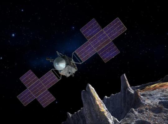
Let's Explore a Metal-Rich Asteroid 🤘
Between Mars and Jupiter, there lies a unique, metal-rich asteroid named Psyche. Psyche’s special because it looks like it is part or all of the metallic interior of a planetesimal—an early planetary building block of our solar system. For the first time, we have the chance to visit a planetary core and possibly learn more about the turbulent history that created terrestrial planets.
Here are six things to know about the mission that’s a journey into the past: Psyche.
1. Psyche could help us learn more about the origins of our solar system.
After studying data from Earth-based radar and optical telescopes, scientists believe that Psyche collided with other large bodies in space and lost its outer rocky shell. This leads scientists to think that Psyche could have a metal-rich interior, which is a building block of a rocky planet. Since we can’t pierce the core of rocky planets like Mercury, Venus, Mars, and our home planet, Earth, Psyche offers us a window into how other planets are formed.

2. Psyche might be different than other objects in the solar system.
Rocks on Mars, Mercury, Venus, and Earth contain iron oxides. From afar, Psyche doesn’t seem to feature these chemical compounds, so it might have a different history of formation than other planets.
If the Psyche asteroid is leftover material from a planetary formation, scientists are excited to learn about the similarities and differences from other rocky planets. The asteroid might instead prove to be a never-before-seen solar system object. Either way, we’re prepared for the possibility of the unexpected!
3. Three science instruments and a gravity science investigation will be aboard the spacecraft.
The three instruments aboard will be a magnetometer, a gamma-ray and neutron spectrometer, and a multispectral imager. Here’s what each of them will do:
Magnetometer: Detect evidence of a magnetic field, which will tell us whether the asteroid formed from a planetary body
Gamma-ray and neutron spectrometer: Help us figure out what chemical elements Psyche is made of, and how it was formed
Multispectral imager: Gather and share information about the topography and mineral composition of Psyche
The gravity science investigation will allow scientists to determine the asteroid’s rotation, mass, and gravity field and to gain insight into the interior by analyzing the radio waves it communicates with. Then, scientists can measure how Psyche affects the spacecraft’s orbit.

4. The Psyche spacecraft will use a super-efficient propulsion system.
Psyche’s solar electric propulsion system harnesses energy from large solar arrays that convert sunlight into electricity, creating thrust. For the first time ever, we will be using Hall-effect thrusters in deep space.
5. This mission runs on collaboration.
To make this mission happen, we work together with universities, and industry and NASA to draw in resources and expertise.
NASA’s Jet Propulsion Laboratory manages the mission and is responsible for system engineering, integration, and mission operations, while NASA’s Kennedy Space Center’s Launch Services Program manages launch operations and procured the SpaceX Falcon Heavy rocket.
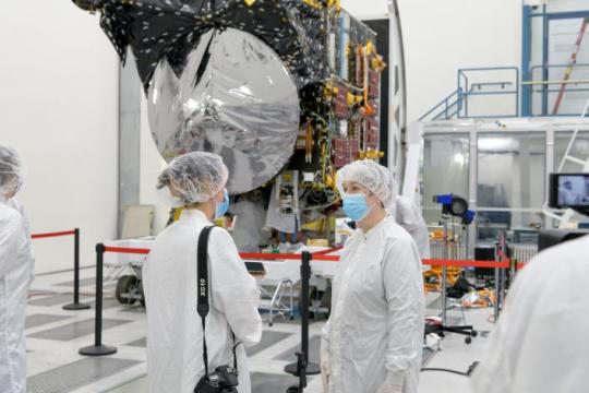
Working with Arizona State University (ASU) offers opportunities for students to train as future instrument or mission leads. Mission leader and Principal Investigator Lindy Elkins-Tanton is also based at ASU.
Finally, Maxar Technologies is a key commercial participant and delivered the main body of the spacecraft, as well as most of its engineering hardware systems.
6. You can be a part of the journey.
Everyone can find activities to get involved on the mission’s webpage. There's an annual internship to interpret the mission, capstone courses for undergraduate projects, and age-appropriate lessons, craft projects, and videos.
You can join us for a virtual launch experience, and, of course, you can watch the launch with us on Oct. 12, 2023, at 10:16 a.m. EDT!
For official news on the mission, follow us on social media and check out NASA’s and ASU’s Psyche websites.
Make sure to follow us on Tumblr for your regular dose of space!
#Psyche#Mission to Psyche#asteroid#NASA#exploration#technology#tech#spaceblr#solar system#space#not exactly#metalcore#but close?
2K notes
·
View notes
Text

CIPHER MANUSCRIPT [aka VOYNICH MANUSCRIPT] by Roger Bacon[?] (Central Europe, c.1401-1599) 18th -19th century binding.
‘Scientific or magical text in an unidentified language, in cipher, apparently based on Roman minuscule characters; the text is believed by some scholars to be the work of Roger Bacon since the themes as the illustrations seem to represent topics know to have interested Bacon…. A history of the numerous attempts to decipher the manuscript can be found in a volume edited by R.S Brumbaugh THE MOST MYSTERIOUS MANUSCRIPT: The Voynich “Roger Bacon” Cipher Manuscript (Carbondale, IL, 1978). Although several scholars have claimed decipherments of the manuscript, for the most part the text remains an unsolved puzzle.’ — from an abstract by the Beinecke Rare Book and Manuscript Library at Yale

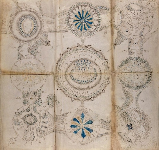


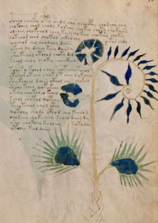
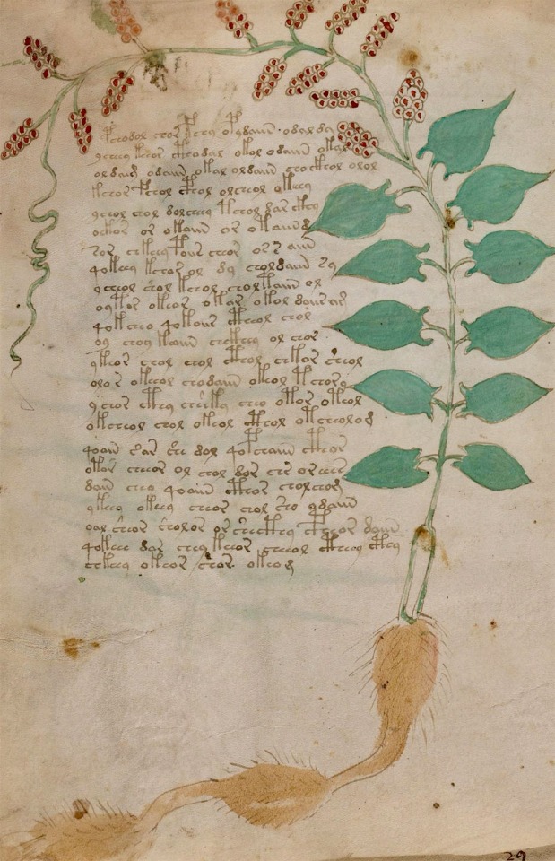
source [digitized]
#beautiful books#book blog#books books books#books#incunabula#illustrated book#ciphertext#cipher#roger bacon#voynich manuscript#the voynich code#mystery#biological diversity#symbols#rare books
317 notes
·
View notes
Text
This article came out about a week ago but it’s one of the coolest I’ve seen on the subject in a bit…
The manuscripts have 2 stories, one about Sir Gwaine, another focusing on Arthur, Guinevere, and Merlin in the court. The manuscript here was likely a “luxury item” for those familiar with Old French but “someone at Huntingfield Manor in Suffolk in the 16th century settled on the old parchment as a bit of raw material to strengthen a ledger” — likely because the value had depreciated after the stories were translated into English.
Some of the text was stitched into the binding or folded over so the people at Cambridge are using CT scans and multispectral imaging “to take hundreds of photographs of parts of the manuscript that were hidden”

Above is the main image of the manuscript from the Cambridge University Library, used in the header of the article.

And the manuscript after imaging… (also from the Cambridge University Library)
#genuinely this is so so incredible#im gonna throw up#like im sorry this is just so so cool#txt#article#arthuriana#new york times#cambridge library
13 notes
·
View notes
Text
41 notes
·
View notes
Text
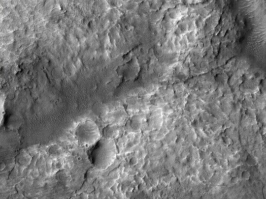
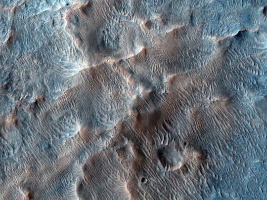
HiPOD: Mounds on the Floor of Kashira Crater
Light-toned mounds on the floor of Kashira Crater exhibit signature of aluminum-phyllosilicates or hydroxylated silica in CRISM multispectral data. Mars Orbiter Camera images show networks of ridges on the mound surfaces, possibly resistant fractures resulting from alteration or cementation by fluids. Some surfaces have a polygonal texture. (Black and white cutout is less than 5 km across; enhanced color is less than 1 km.)
ID: ESP_029053_1525 date: 7 October 2012 altitude: 257 km
NASA/JPL-Caltech/UArizona
65 notes
·
View notes
Text
The different Mars Rovers and what we learned
Sojourner (1997)
First rover to successfully land on Mars. Defined by NASA as a "micro-rover" due to its small size, Sojourner had a speed of maximum of 0.4 meters pr. minute. It was active for about 80 days on the surface of Mars.
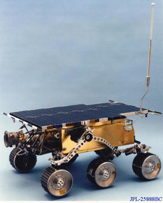
Sojourner carried three cameras, an Atmospheric Structure Instrument (Meteorology Package) and an Alpha Proton X-ray Spectrometer. There instruments.
From Sojourner, NASA learned about the surface and weather conditions of Mars.
Sojourner found rounded rocks at the landing site, which suggests that running water could have been on Mars. The radio-tracking of Pathfinder (mission name) also gave an estimate of Mars' metal core's size (1300 kilometers to 2000 kilometers). It also discovered that the dust that is in the air on Mars is magnetic and possibly made up of mahemite. Sojourner also observed dust devils, ice clouds in the lower atmosphere and temperature fluctuations on the surface of Mars.
Spirit (2004-2010) and Opportunity (2004-2018)
Spirit was one of two Mars rovers launched in 2003 (mission started in 2004). The wheels on Spirit and Opportunity were about double the size of Sojourners. The weight of both rovers was about 17 times Sojourners, and more than double the size. Their goal on Mars was to search the surface for traces of past water. In 2009, Spirit got stuck in soil (in the area called Troy). In 2010, Spirit stopped communications, and the mission ended in 2011.
Opportunity was launched in 2004 along with Spirit but lasted much longer than their twin. Setting the record for the longest-lasting Mars rover, Opportunity stopped communications in 2018. Opportunity also set the record for the longest distance traveled by a rover, around 45 kilometers.
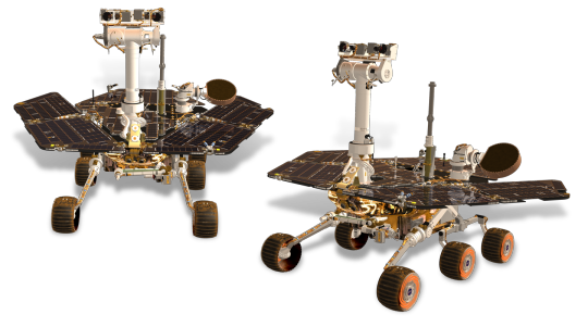
Like Sojourner, Spirit provided data about Mars' weather conditions, especially the wind. Both Spirit and Opportunity found evidence of possible conditions on Mars that could allow microbial life.
Spirit and Opportunity both had panoramic cameras, a thermal emission spectrometer, a Moessbauer spectrometer, an alpha particle X-ray spectrometer, and a microscopic imager.
Curiosity (2012-present)
Curiosity is currently the oldest active Mars rover (as of 21/07/2023) The main purpose of Curiosity is to figure out if Mars has the right environment for microbial lifeforms. Curiosity is currently exploring Gale Crater and had the most advanced instruments at the time. Curiosity has found evidence of water having been on Mars in the past, found old organic material, and discovered that Mars has had a thicker atmosphere in the past.
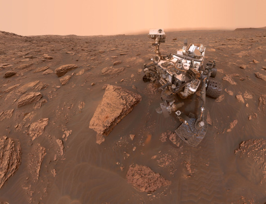
Curiosity can climb over knee-high obstacles and can go up to 30 meters per hour.
Curiosity carries a radioisotope power system to generate electricity, which gives the rover a steady electricity flow. Curiosity also carries 17 cameras, a laser, a drill, and 10 different instruments.
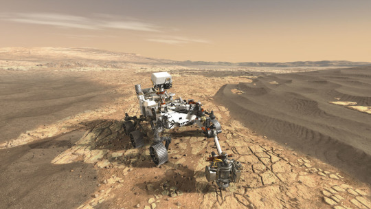
Perseverance (2021-present)
Perseverance is the newest Mars rover from NASA. The main goal for Perseverance is to research habitable conditions on Mars, but also for signs of past microbial life. The mission also tests possible options for future human expeditions on Mars (ex. improved landing techniques, producing oxygen from the atmosphere and environmental conditions).
The drill Perseverance used can collect samples and then set them aside for collection on the surface.
Zhurong (2021-2022)
Launched by the CNSA, Zhurong is the first Chinese Mars rover. In 2022 it became inactive due to sandstorms and the winter, which prevented it from waking at an appropriate temperature and good sunlight conditions.
Zhurong's mission was to study the topography, examine the surface (soil and elements), and take samples of the atmosphere. To do this it had a RoPeR (Mars Rover Penetrating Radar), RoMAG (Mars Rover Magnetometer), MCS (Mars Climate Station), MarSCoDE (Mars Surface Compound Detector), a multispectral camera and navigation and topography cameras. It also had a remote camera on board.

#astronomy#mars rover#sojourner#spirit#opportunity#curiosity#perseverance#zhurong#nasa#source: mars.nasa.gov#source:wikipedia#mainly for zhurong
54 notes
·
View notes
Text

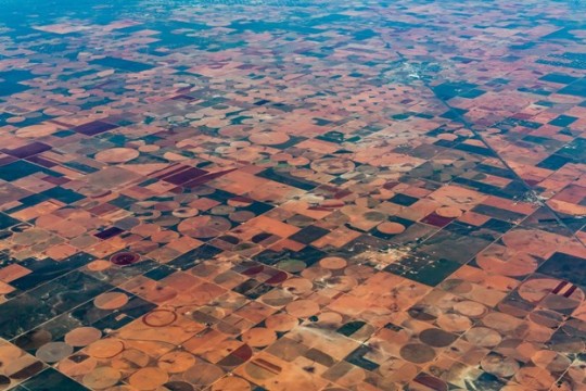
Satellite Data Show Motion of Burma Earthquakes
At about 12:50 p.m. local time on March 28, 2025, a magnitude 7.7 earthquake started near the city of Mandalay, Burma (Myanmar). Twelve minutes later, the region shook again from a magnitude 6.7 quake with an epicenter about 31 kilometers (19 miles) to the south.
Originating at a depth of 10 kilometers (6 miles) on the Sagaing Fault, the earthquakes triggered intense shaking and building collapse near the epicenters. Infrastructure damage occurred as far away as Bangkok, Thailand, about 1,000 kilometers (600 miles) to the southeast.
Researchers at NASA’s Jet Propulsion Laboratory in Southern California used data from radar and optical satellites to visualize how the land moved during these quakes. In the map above, red pixels indicate northward motion, while blue pixels show movement to the south. The data highlights ground displacements of more than 3 meters (10 feet) along portions of the fault, for a total offset of more than 6 meters in some places.
The map is based on data from the Advanced Rapid Imaging and Analysis (ARIA) team at JPL and the California Institute of Technology’s Seismological Laboratory, a team that develops state-of-the-art deformation measurements, change detection methods, and physical models for use in hazards science and response.
The ARIA team drew from radar and optical data acquired by the European Space Agency’s Copernicus Sentinel-1A and Sentinel-2B/C satellites. Sentinel-1A employs synthetic aperture radar (SAR) to image the land surface using microwave pulses, while the Sentinel-2 satellites acquire optical data through an onboard multispectral sensor. Using data from the three satellites, the ARIA team computed estimates of horizontal ground motion within the earthquake rupture zone by tracking pixel offsets between pre- and post-earthquake images.
Models produced by the U.S. Geological Survey (USGS) indicated the earthquakes likely resulted from strike-slip motion along the north-south-oriented Sagaing Fault, which is at the interface between the Indian and Eurasian tectonic plates. The data in the image confirm right lateral strike-slip motion along the fault and help to constrain modeled estimates of fault rupture extent and surface displacement due to the earthquakes.
This region has a history of significant seismicity, with six earthquakes of greater than 7.0 magnitude occurring within about 250 kilometers (150 miles) of the March 28 quakes since 1900, according to the USGS. The surface rupture generated by the March 28 earthquakes has been estimated, based in part on the data shown, to span 550 kilometers (342 miles) in length. With a rupture extending from north of Mandalay to south of Burma’s capital, Nay Pyi Taw, it is one of the longest documented strike-slip fault-induced surface ruptures on record.
Preliminary analyses of the rupture by other scientists found that, in addition to being especially long, it was also remarkably fast, suggesting it may have been a rare “supershear” earthquake. In these events, the slip along the fault moves faster than the seismic waves it produces, which can concentrate seismic energy ahead of the rupture. The effect may exacerbate a quake’s destructive forces and might be part of the reason why the recent events caused so much damage so far from the epicenters.
NASA Earth Observatory map by Michala Garrison, using data provided by the ARIA team at NASA/JPL-Caltech. The map is based on Sentinel-1A and Sentinel-2B/C data provided by the European Space Agency and processed by ARIA team members Robert Zinke and Cole Speed (JPL). Story by Andrew Wang (JPL) and Lindsey Doermann. Science review by Grace Bato and Eric Fielding (JPL).
2 notes
·
View notes
Text
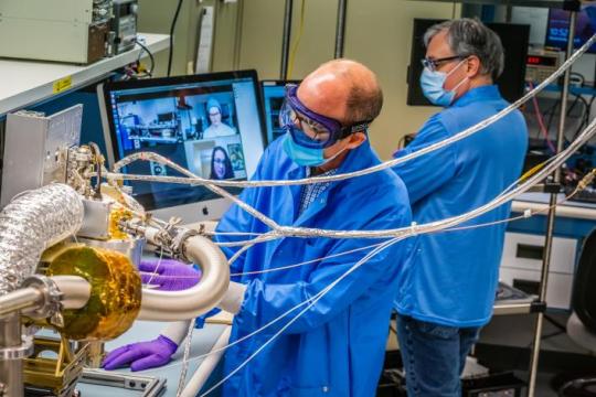
I.R.I.S- Integrated Retinal Imaging System
This is a device integrated into the organic matter of the eye, utilizing metasurface structures integrated around the outer layer of the iris to transmit multispectral visual data into the retina, which is further processed by software integrated into the brain.
It is a unique cybertronic device, powered by a microbattery and computer placed in the visual cortex.
I.R.I.S allows Ada to see into spectrums such as the Electromagnetic, Infrared, Ultraviolet; enhances her capacity to see in the dark, enhances her ability to track patterns, gauge range and distance of targets.
It does all this without interfering with the brain's natural perception altering strategies for dealing with tasks.
2 notes
·
View notes
Text
Focal plane #units and #imaging #systems: unique focal plane units for high-resolution #Earth observation satellites.
0 notes