#lahar flow
Explore tagged Tumblr posts
Text


Kanlaon Volcano in Negros Occidental, Philippines spewed thick plume at the height of 3,000 meters on December 9, 2024.
It's now the most active volcano in the country under Alert Level 3.
The Philippine Institute of Volcanology and Seismology
(PHIVOLCS) advised residents to stay away from the volcano and evacuate within the 6-kilometer radius of the volcano.
Stay Safe.
#volcano#volcanic eruption#Kanlaon Volcano#Negros Occidental#Philippines#alert level 3#smoke#ash#lava#lahar flow
22 notes
·
View notes
Text
Fun volcano fact
Did you know?
Although Lava is the most notable part of a Volcanic Eruption, they're usually the least deadly part.
Other Less notable (but way more deadly things) that come from Volcanoes are:
Pyroclastic Flows, massive rolling mixtures of Ash, Tephra, Rocks and Boulders that move extremely fast and will kill you
Volcanic Bombs, the term given to Boulders that are violently thrown off the sides of Volcanoes that weigh in tons and can crush literally anything they land on (very unpredictable)
Ash itself, which, although it doesn't seem threatening, they can suffocate you if you're outdoors, cover hundreds of square miles, suffocate all life in their area, and even if you're inside, your building's roof can collapse because only 5cm of buildup on a roof is equivalent to a massive slab of rock
Lahars, which are flash floods mixed with ash and sharp rocks that come from melted ice. they happen extremely quickly, can drown you, are like a massive attack of shiny knives, destroy tons of infrastructure and contaminate water supplies
Don't fuck around with volcanoes they will kill you and you wont expect it
1 note
·
View note
Text
Pyroclastic flow guy from earlier is kinda wrong, Mt. St. Helens wasn't very deadly and most of the damage wasn't caused by pyroclastic flow. Only 57 people died, and most of those were from the mountain exploding directly sideways. The pyroclastic flow barely impacted the area compared to the lateral blast. The reason so few people died is because everyone left before the mountain blew up :)
why didn't they just leave pompeii when the volcano erupted? were they stupid?
#also all the other volcanoes in the cascade range don't cause problems with pyroclastic flow#they cause problems via ash mostly#and lahars which are combo landslides and floods from all the snow on them melting at once
78K notes
·
View notes
Text


1, 2: Balancing rocks formed by two separate lava flows - a cooler flow below, a hotter lahar above. The hot lahar layer erodes more slowly than the layer below, leaving pillars carved by millions of years of erosion with little capstones on top that have protected the softer rock below them.
3. Frozen waterfall found in the stand of ponderosa pines at the base of the lake in photos 1 and 2.
#oregon#just some photos from the weekend#I'm fed up with IG and so I might start posting more photos here when I feel like it
76 notes
·
View notes
Text

As seems to happen fairly regularly, I found myself in the John Day Fossil Beds again, leading and helping out with geology hikes through the hills.


The particular topics I wanted people to get out of this hike was the relationship between rock strength and landscape shape. See the round, symmetric hill in the center of the above photo? It is made of almost unconsolidated (soft) clay and silt with very low strength. Below it is a cliff ledge of much harder rock, an ancient lahar (volcanic mudflow) which turned to concrete-like stone after flowing down an ancient river valley. This harder rock sits directly below the soft clay, holding it up.
Even in places where rocks and hills all look roughly the same, as in this part of Oregon, there is often incredible nuance to be found within the landscape.
#oregon#geology#photography#pacific northwest#adventures#bettergeology#rocks#landscapes#eastern oregon#geography#Oregon geology
78 notes
·
View notes
Text
Guys i love my very normal wife. The wife that is not an active volcano. My wife is not an active volcano why would you think that. My wife has normal human skin and is not made mostly of andesite. She is a human woman and not a volcano. My wife is a normal human height and not 8.3k ft tall. What. She is NOT known for explosive eruptions OR pyroclastic flows OR ash plumes OR lahars OR landslides. You are crazy. CRAZY. I love my wife
Ok bye ty for listening
152 notes
·
View notes
Text
Everyone knows volcanoes are dangerous, and yet it is just how many ways volcanoes can kill you: pyroclastic flows, falling bombs and cinders, earthquakes, landslides, lahars, poisonous gases, ash clouds blocking the sun causing famine, tsunamis from debris hitting the ocean, ect
Pretty impressive killing machines. Too bad they create valuable land.
41 notes
·
View notes
Text
My pain becomes
an angry volcano
erupting outward
pain of being unwanted
clashing with desire
simmers under the surface
Old. Sagging face
sagging everywhere
Nothing perky.
Outliving my usefulness
in a society
that values youth
and beauty for women
Your stares at me
are dead earth.
No fire.
And I feel the conflict
of still BURNING
for something
banging against
the knowledge that
it is expected
to not be desired
in my current form
The lahar flows
I struggle against
the boiling river
to build myself up
But I am drowning
in scorching water
~ Zelpha Frost 2023 - Birthday Poem
49 notes
·
View notes
Text
Wordplay Wednesday: Conglomerate
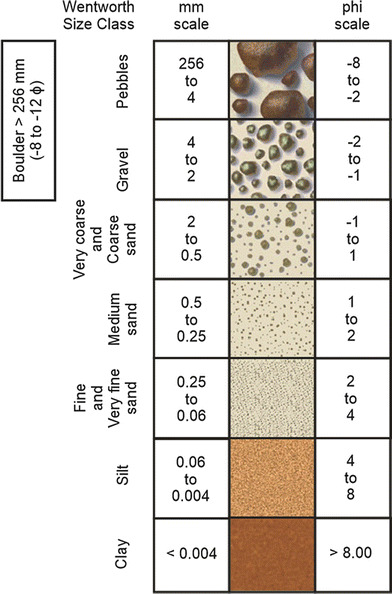
What is a conglomerate? It is a type of sedimentary rock that is characterized by it's rounded gravel, pebble, or cobble-sized grains cemented together by silica, calcite, or iron oxide.
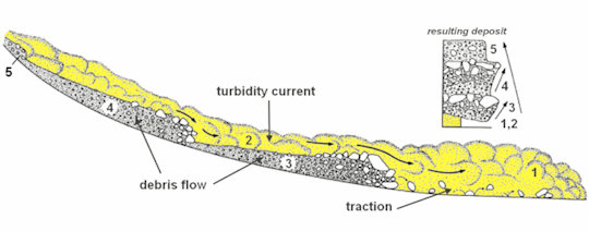
There are many ways in which a conglomerate can be formed. Turbidites are deep marine conglomerates created by turbidity currents.
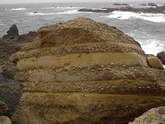
Many are fluvial in nature and occur in rivers with a high flow rate (immature river systems) such as the Buckhorn Conglomerate of the Cedar Mountain Formation in Utah, USA.
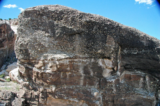
Alluvial fans along mountain fronts tend to make the thickest conglomerates. These are often called fanglomerates.
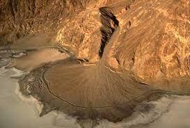
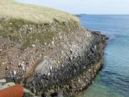
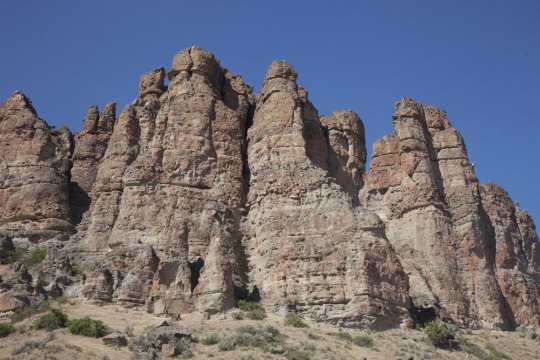
Debris flows also deposit conglomerates such as the Clarno Formation in John Day National Monument which was deposited by a lahar or volcanic mudslide.
Glaciers create tillites, a very poorly sorted type of conglomerate (no discernable pattern to size or shape of grains).
#geology#fun facts#rock formations#stratigraphy#conglomerate#John Day Fossil Beds#national monument#cedar mountain formation#lahar#volcano#river channel
18 notes
·
View notes
Text
Lahars
My mind is still on Volcanoes obviously because there is a lot of potential danger, a lot of different dangers. Lava, pyroclastic flows, ash and pumice that can collapse roofs and ground planes.
Volcanoes can throw heavy debris in the air, produce deadly gasses, and burning steam.
Then there are Lahars, volcanic mud flows. Sometimes a snow or glacier covered volcano will erupt and all that melting water goes on a rushing rampage down hill.
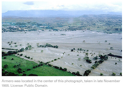
How deadly can these get? In 1985 in Colombia the volcano Nevado del Ruiz erupted, sending a lahar careening downhill toward the town of Armero.
20,000 people were killed.
Lava might be flashier, gasses harder to detect, but lahars can really mess things up.
#environmental whump#volcanoes#disaster history#I have so many disaster facts in my brain#they just come spilling out sometimes
7 notes
·
View notes
Text
Heavy rains and torrents of cold lava and mud flowing down a volcano's slopes on Indonesia’s Sumatra island triggered flash floods that killed at least 37 people and more than a dozen others were missing, officials said Sunday Monsoon rains and a major mudslide from a cold lava flow on Mount Marapi caused a river to breach its banks and tear through mountainside villages in four districts in West Sumatra province just before midnight on Saturday. The floods swept away people and submerged more than 100 houses and buildings, National Disaster Management Agency spokesperson Abdul Muhari said. Cold lava, also known as lahar, is a mixture of volcanic material and pebbles that flow down a volcano’s slopes in the rain.
Continue Reading.
9 notes
·
View notes
Text

Landscape Language
Edifice (noun) – the main portion of a volcano
Mount Rainier’s edifice is an icon of the Pacific Northwest. In geologic terms, the “edifice” is the main portion of a volcano built by eruptions of lava, tephra, pyroclastic flows, lahars, and other deposits. Modern Mount Rainier is relatively young, around 500 thousand years old, and its edifice includes rocks of many ages. Some of the youngest lava flows are under the Emmons Glacier (2.2 thousand years ago) and on the summit crater. Mount Rainier’s edifice is built on a foundation of the much older Cascade Range, which began forming 10 million years ago.
NPS Photo of Mount Rainier from Tolmie Peak. ~kl
52 notes
·
View notes
Text

November 1985 marks a before and an after in Colombia. [...]
[A] squadron of [...] guerillas stormed the Palace of Justice in Bogota. [...] A belligerent military response [...] resulted in at least one hundred deaths. [...] For two decades, Colombia’s civil war had been raging on mountains and in jungles. Now, it had arrived in the country’s capital. A week later, on November 13, a sleeping giant stirred some two hundred kilometers west of Bogotá. After lying dormant for over 140 years, the Nevado del Ruiz exploded in two eruptions. From the Andean volcano’s crater surged boiling lahars, which descended the mountain at speeds of one hundred kilometers an hour. [...] This monstrous debris flow decimated almost everything in its path, engulfing the regional cotton-producing town of Armero and killing the majority of its twenty-five thousand inhabitants. [...] The government’s ensuing response to the Armero disaster was characterized by inefficiency, miscommunication, and corruption. [...] [M]onetary aid went missing. Unidentified child survivors were taken by authorities and put up for adoption. No effort was made to locate their relatives. [...]
---
In his 2016 book Endangered City, [...] Austin Zeiderman analyzes coverage of November 1985 in the Colombian print press. [...] [R]eporters used the language of forewarning to denounce the government for its failure to avert the convergent crises. Several columnists played with the title of Gabriel García Márquez’s Chronicle of a Death Foretold, a pseudo-detective novel [...]. One 1985 headline [...] called the Armero landslide “a forecast apocalypse.” “We have become the land of tragedies forewarned,” so the article read [...]. Even as the siege and the eruption were treated as spontaneous catastrophes, so, too, were they framed as self-fulfilling prophecies. History was being written in the subjunctive. As the temporal breadth of the convergent crises expanded, they acquired the characteristics of “slow-onset disasters.” Rob Nixon, among others, has written of the difficulties in visualizing catastrophes that gradually unfold [...] over lengthy periods. [...]
In the context of the Anthropocene, artists are increasingly tasked with what Latin American studies scholar Joanna Page describes as “taking up the challenge of representing geological and cosmic time [...].” One such artist is Santiago Reyes Villaveces, who presently lives in the shadow of the Nevado del Ruiz, and whose work uses multimedia methods to explore the volcano. His video installation Orbit, currently on view at New York’s Instituto de Visión, tells a version of the November story.
The fall of 1985 is framed in an imperialist chronology, where disasters are continuities, not ruptures [...].
---
The protagonist of Orbit is a two-hundred-ton boulder that once sat at the heights of the Nevado del Ruiz. On the night of the eruption, it traveled over forty-five kilometers, and was deposited in the center of Armero shortly before midnight. Today, it is a landmark in a ghostly town that, like Herculaneum, stands in ruins. However, unlike its Italian counterpart, Amero receives no conservationist funding or legislative protection.
In the absence of state investment, the rock has become an unofficial monument to the dead. Every year, it attracts hundreds of tourists and mourners. [...]
---
The disaster industry is one branch of the export economies that dominate life in this mineral-rich region known as the macizo.
Correspondingly, there looms the specter of another disaster: the European invasion of the Americas.
In its inaugural exhibition, Orbit appeared in 2019 alongside seven other sculptural installations named Anus, Puddle, Navel, Brick, Fever, and Room Temperature. These works are made with gold, silver, copper, limestone, and rubber -- the same raw materials that drove the expansion of the Spanish empire. Centuries later, they still fuel the competition for resources [...].
---
Displayed in a museum setting alongside tools of measurement and unearthing, they create an “extractive viewpoint,” a phrase from scholar Macarena Gómez-Barris. [...] Gómez-Barris compares this vantage to the colonial gaze. Per her definition, it “facilitates the reorganization of territories, populations, and plant and animal life into extractible data and natural resources for material and immaterial accumulation.”
The macizo region is thus placed in a matrix of colonial relations that operates on an accumulative timescale.
Rather than regard the Conquest as a finite event, work like Reyes Villaveces’s urges us to think, instead, of a “colonial presence” that has endured throughout the postcolonial period. In conjuring this notion of history as perpetuity, anyone who sees such art is challenged, with Ann Laura Stoler, “to refuse the quick resort to ‘before’ and ‘after’ -- and even to work against the wooden, if all too common, conceptual containers of ‘past’ and ‘present.’” [...]
---
[E]thnographer Beatriz Nates Cruz [...] argues that inhabitants of the macizo reside in multiple worlds that converge around symbolic landmarks and that operate according to their own discrete laws of space-time. [...]
Survivors of the Armero tragedy also return to the disaster site to stand awhile next to the departed. On each anniversary, the bereaved attend commemorations among the ruins and visit the rudimentary graves of their loved ones [...]. Darío Nova aims to foster reflection, spirituality, and healing. [...] More recently, he has led an initiative called Time and Memory that has seen participants use colorful string to frame features in derelict homes and place figurines on sills and mantles. These interventions make of Armero a museum curated by a grassroots collective that addresses a lack of governmental interest [...].
---
Confronted with this institutional indifference, we might return to the concept of negative gravity. We have seen how this phenomenon shapes a history of extraction, occupation, and conflict that propels state-making in Colombia. [...]
One of the remarkable things about disasters -- perhaps even their defining feature -- is that they cause the convergence of temporalities that usually coexist, but that do not necessarily intersect, or at least not in ways that are easily discernible. The 1985 eruption of the Ruiz volcano created a collision between this dimension of geological time, which spans billions of years and the expanses of space; centuries of imperialist expansion, capitalist accumulation, and national development; and the infinitesimal scale of a single human life span. All of this took place in a matter of seconds [...].
Survivors attest that time stops as disaster strikes. As these crises climaxed, the clock stopped ticking. But these disasters also accelerated the juggernaut of history that predated that November. They spliced experiences of time into a before and an after, causing it to move in new directions.
---
Images, captions, and all text above by: Rebecca Jarman. “Before and After? Temporalities of Disaster.” e-flux Journal Issue #135. April 2023. [Bold emphasis and some paragraph breaks/contractions added by me.]
#abolition#ecology#imperial#colonial#interspecies#temporality#sick architecture#geographic imaginaries#indigenous#ecologies#caribbean#tidalectics#andes#indigenous pedagogies#black methodologies
23 notes
·
View notes
Text
Hello!
Today I learned that in 79 CE, when Mt. Vesuvius erupted, it destroyed two cities. The city of Pompeii, and the city of Hurculaneum.
The catastrophies that happened at both of these cities were caused by pyroclastic density currents (also know as PDCs or Pyroclastic flows). These were large plumes of hot, dense ash and debris from the explosive eruption of Vesuvius. (AKA not Lahars)
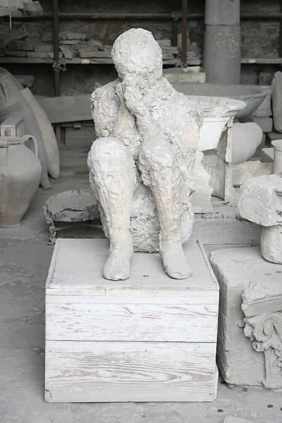
In Pompeii, these PDCs were much cooler than the ones at Hurculaneum, and so the people were buried in ash and ultimately died of suffocation and not at the hands of temperature. The people buried left voids in the solidified ash filled with bones and sometimes clothing. Someone eventually got the bright idea to dump Plaster of Paris into these voids, and that's where we get the creepy and tragic statues of the people of Pompeii.
In Hurculaneum, the town was victim to whats called pyroclastic surges (a less dense, hotter version of a flow). They were extremely hot. The temperature was hot enough to kill anyone hit by it nearly instantly. It hit most of the town and the rest was covered by a lahar (volcanic mud/debris flow). We know this because the bones found in Pompeii were mostly intact and non-discolored. The bones in Hurculaneum, however were extremely discolored and there were no clothing remnants. Archaeologists later found that this kind of discoloration of bone only happens when they're exposed to extreme temperatures. (Teacher didn't cite the source for this one, cursory looks say this might be disproven in the past decade. He's usually pretty up-to-date though.)


Notice that there is no space between the surrounding "dirt" and the skeletons. The "dirt" here is volcanic product.
I highly recommend giving this article a read if you're interested in learning more about what happened in Hurculaneum. :)
14 notes
·
View notes
Text
That moment when you realize the 50th Hunger Games had an eruption was sheer dumb luck. Because if the Capitol had the power to cause earthquakes and eruptions they would have won the war. That’s not a question. That’s a fact. You have the ability to drop a magnitude 8-9 no one is going to survive to rebel.
Like the most they could have done is control the amount of damage in the arena. Which would explain how somehow only half of the career pack died when all 10 should have.
Though I still have questions because either that was a viscous eruption which doesn’t make sense since those are slow. Which means most of the tributes should have been able to get out of the way. And before someone goes ‘oh maybe they didn’t hear it’. Those things aren’t quiet. They aren’t as loud as the explosive styles but they aren’t quiet either.
Or you had an explosive style eruption aka like Mt St Helen’s. In which case why were the lava flows the only issue? Even if you manage to contain it. Landslides, Lahars, volcanic bombs, and hell the ash cloud would still present a challenge before the Game Makers could have stopped them.
Like the lahars and the landslides I can kind of hand wave as being related to the ecological changes. Because that actually makes sense. But the other stuff again because again if they had that much control over Mother Nature where they could drop an earthquake or cause a volcanic winter than they would never have lost the war.
Like credit to SC for not making my head hurt too much about the science in the books. But my geo loving side of the brain just can’t ignore this.
4 notes
·
View notes
Text
Togawa Jun - Teinen Pushiganga
Allegedly the title comes from a phrase for sitting in a cirlce and drinking. So we're making merry over resigning yourself from personhood. Translation notes at the end and personal commentary too because fuck it, a blog's a blog.
youtube
English
Far beyond the sky float the clouds Oh, in the name of my love
Such acts of atrocity No more can I resign to forgiveness
You may kill me Like a cow Or like a pig It’s alright I am merely a piece of flesh
Lala lala la Lala lala lai I am merely a piece of flesh
Into the sky fades the midday canon Oh, for my love has ended
Both love and hatred Are no more, poured into nothing
In a single moment of disgust I begin to rot I am merely a piece of flesh
Lala lala la Lala lala lai I am merely a piece of flesh
Far beyond the sky float the clouds Oh, in the name of my love
Such acts of atrocity No more can I resign to forgiveness
You may kill me Like a cow Or like a pig It’s alright I am merely a piece of flesh
Lala lala la Lala lala lai I am merely a piece of flesh
Japanese
空の彼方に 浮かぶは雲 嗚々 我が恋愛の名において
その暴虐の 仕打ちさえ もはやただ 甘んじて許す
牛のように 豚のように 殺してもいい いいのよ 我 一塊の肉塊なり
ライラ ライラ ラ ライラ ライラ ライ 我 一塊の肉塊なり
空に消えゆく お昼のドン 嗚々 我が恋愛は終止せり
あの泥流の 恩讐が もはやただ あとかたもなしや
愕然とする間もなく 腐敗し始める 我 一塊の肉塊なり
ライラ ライラ ラ ライラ ライラ ライ 我 一塊の肉塊なり
ライラ ライラ ラ ライラ ライラ ライ 我 一塊の肉塊なり
空の彼方に 浮かぶは雲 嗚々 我が恋愛の名において
その暴虐の 仕打ちさえ もはやただ 甘んじて許す
牛のように 豚のように 殺してもいい いいのよ 我 一塊の肉塊なり
ライラ ライラ ラ ライラ ライラ ライ 我 一塊の肉塊なり
ライラ ライラ ラ ライラ ライラ ライ 我 一塊の肉塊なり
ライラ ライラ ラ ライラ ライラ ライ 我 一塊の肉塊なり
ライラ ライラ ラ ライラ ライラ ライ 我 一塊の肉塊なり
ライラ ライラ ラ ライラ ライラ ライ 我 一塊の肉塊なり
ライラ ライラ ラ ライラ ライラ ライ 我 一塊の肉塊なり
Translation Notes
泥流 is the flow of lahar/volcanic mud when a volcano erupts and 跡形もなしや (written in hiragana as あとかたもなしや) is like "without leaving a trace", I thought saying literally saying left without a trace was too basic for such a powerful song, so I went with "poured into nothing" to maintain the original imagery and meaning.
Personal Commentary Nobody Asked For
Many lifetimes ago I ran the Jun Togawa Forever fansite with my friend Pat, he translated all of the songs and I did the website... stuff. Because of it, Pat got to meet Jun's manager and it was basically the thing that set me off onto wanting to study Japanese to begin with. The sadness I was experiencing at the time couldn't be expressed in my own language because I was barely fresh off being a teenager, and I was treated poorly by almost everyone around me. Real "nobody understands me" type shit. So, i'd listen to this song on repeat a lot and read my friend's translation, because it felt like somebody understood me.
The reason I stopped running the website, posting throwbacks and setlist updates etc was because I actually hated most of the English fans. Pat was working very hard at a critical time to translate information and whenever I had a question, I would ask. But people kept jumping to assumptions about what Jun's art was trying to convey. It sounds almost cliche, but the perspective of dudes with no knowlege of Japanese language or culture was dominating the discussion about a Japanese woman's work, stripping it of time, place and it's author. One person's self expression through art became a talking point for being anti-pop culture - because it was antithetical to the norm, that's all it could be, or that became the main focus. I hated how our work was just being consumed by people who's reaction was just "cool" or "thanks", and the voice behind the lyrics was stifled for the sake of making hamfisted commentary about pop culture, from a society and culture that the authors themselves had sparse knowlege of.
It is extremely petty. This was also before Suki Suki Daisuki blew up on Tiktok too. But, the phrase "anti idol" just screamed fake deep to me lol. Once I actually started speaking Japanese and explaining the perspective of non-Japanese people about things to Japanese people, they were mostly confused. BiS' producer also called it "fucking stupid." I think about deleting all of the translations sometimes out of spite.
I wanted to come back and translate this song myself because... fuck it, why not. I'm not in the same mindset as when this was the one thing keeping my head above water, but I did have some poor experiences with people at university recently. I thought about this song because it feels like it's fine for terrible things to be said and done to me, but everyone else is seemingly allowed to do whatever they want. Be it emotionally or sexually as a friend or as a coercer. But i've resigned myself from caring because hey, life goes on.
6 notes
·
View notes