#foulwind
Explore tagged Tumblr posts
Visit Tumblr Blog
Explore Tumblr blogs with no restrictions, modern design and the best experience.
Last Seen Tumblr Blogs


Fun Fact
In February 2021, Tumblr had 518.6 million blog accounts.
Text
Murchison to Hokitika
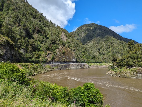
I left Murchison this morning with a bit of a drive ahead of me - if I went the fastest way, it would only take about 2.5 hours. But - this is a roadie! We don't go the fastest way, and we certainly don't go without stopping! So in total, it took me about 7 hours altogether, I think? Obviously, with plenty of stops along the way. Stop number one was a viewpoint in the Upper Buller Gorge. I can't explain the clock, but I thought it was cool and took a picture anyway.


Then, a few more scenic spots along the way - Lower Buller Gorge and the T-Rex Tree! Gotta love people who add things to google maps, so you can stop and see a tree that's shaped like a T-Rex 🦖


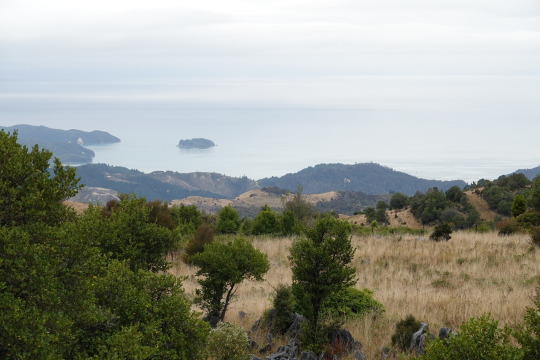
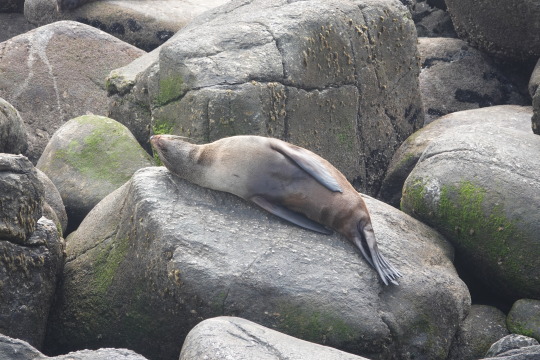
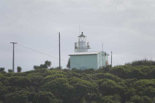
Then, headed over to Cape Foulwind - so named because of the terrible weather and wind when Captain Cook made it around to that area. At Cape Foulwind, I took a short walk to visit the Cape Foulwind Lighthouse, followed by a short drive and a quick walk to see the seal colony in Tauranga Bay. Then another scenic viewpoint along the west coast!


The next substantial stop was the Pancake Rocks in Punakaiki. The Pancake Rocks are a heavily eroded limestone area - the areas between the "pancakes" eroded more (please forgive my rudimentary explanation - it's late and I'm tired). Please enjoy so many pictures of the same rocks 😂


The last stop before Hokitika was Coal Creek Falls. It's a short walkway, about 30 minutes in each direction, to the waterfalls. It did start to rain while I was walking, but other than that, the rain mostly held off unless I was in the car! Double selfie for you here 😎


After the falls, I had a few other places I could have stopped, and a few other walks that would have been worth doing. But honestly, I was beat and ready to check in! Today was the last day of the Driftwood and Sand Festival in Hokitika, so I took a while to wander along the beach to check out the submissions. That will be a whole post on its own because there are too many cool photos to share. Unfortunately, there is a 30 photo limit on these posts, so you'll just get a double today! Here's one of me with goliath to intrigue you!

And, of course, the driftwood Hokitika sign - I am going to get a better picture in the (hopefully!) sun tomorrow, so you'll probably see it again.

2 notes
·
View notes
Text
Die Erkundung der Südinsel beginnt (16.12.-18.12.)
Am 16.12. geht der Wecker an einem sehr regnerischen und windigen Tag, aber es soll noch dicker kommen, wortwörtlich. Beim Zähneputzen trete ich ungl��cklich auf und knicke richtig schön mit dem rechten Knöchel um. Was folgt sind ein fett angeschwollener Fuß, notdürftiges Kühlen mit zwei Coladosen aus unserer Kühlbox, ordentlich Ibuprofen und ein von Torbi echt gut angelegter Verband, der mir zumindest zum Humpeln die notwendige Stabilität gibt. Dann fahren wir zur Fähre, wo alles super gut organisiert abläuft (sollte man auch erwarten bei den fast 500€, die wir für die Fähre hin und zurück hinblättern mussten) und das größte Problem das verstopfte Klo an Bord ist, weil irgendein Vollhorst auf die Idee kam, eine komplett volle Windel darin zu entsorgen... Die Fahrt verläuft trotz des Wetters ruhig und je dichter wir der Südinsel kommen, desto toller werden die Ausblicke auf die Landschaft.
Auf der anderen Insel angekommen machen wir noch ein paar Besorgungen und fahren dann los zur Unterkunft für die Nacht. Vorher gibt es noch - ihr habt es erraten - Burger auf dem Weg, und das war eine super Entscheidung, denn es handelt sich um einen Food Truck auf dem total schönen und grünen Hinterhof eines riesigen Weingutes. Hier gibt es Sitzbänke und -säcke, entspannte Jazzmusik, einen pittoresken Teich und sogar ein paar Sonnenstrahlen! Und das Essen schmeckt auch noch.
Wir entscheiden uns, zuerst an die Westküste zu fahren, und verbringen die erste Nacht deswegen auf dem Weg an die Küste auf einem Campingplatz. Auch hier gibt es wieder einen super süßen flauschigen Hund, wie wir finden, fast das beste an den Campingplätzen! Noch dazu gibt es eine heiße Dusche und der Weg dorthin ist für mich als Krummbein auch nicht allzu weit.
Der nächste Tag versinkt im Regen, weswegen wir ihn damit verbringen, möglichst viel Strecke Richtung Küste zu machen. Auf der Südinsel gibt es wirklich mehr Schafe und Kühe als Menschen, und bei dem Wetter merkt man das noch mehr. Wir fahren teilweise ewig geradeaus, den Scheibenwischer auf Anschlag, und es begegnet uns keine Menschenseele. In der nächsten Nacht machen wir das erste Mal leidvolle Begegnung mit den an der Westküste leider sehr penetranten Sandmücken. Die Biester sind klein, zahlreich und beißen, und die Stiche tun zwar erstmal nicht direkt so weh, jucken aber - wie wir noch leidvoll feststellen werden - teilweise wochenlang richtig schlimm und man kratzt sich im Schlaf die Füße und Knöchel auf. Nicht mal das aggressive Insektenschutzmittel aus Asien hilft dagegen! Wir verziehen uns also pünktlich ins Auto, was bei dem Regen nicht besonders schwer fällt.
Am nächsten Tag machen wir in Saint Arnaud einen Stopp am Lake Rotoiti und sehen dort die fettesten Aale überhaupt (die hier stark unter Schutz stehen) und machen tolle Fotos vom Steg aus in Richtung See. Dann setzt auch schon wieder der Regen ein (Überraschung!) und wir fahren weiter an die Küste. Die Fahrt ist jetzt teilweise richtig abenteuerlich, da die Straße durch das Tal führt, das ein Fluss (bzw. vorher mal ein Gletscher) hier durch den Stein gegraben hat. Die Straße ist kurvig und eng, an einigen Stellen führt sie einspurig in einer Scharte durch den Stein, die Ausblicke sind fantastisch (die ich grenzenlos genießen kann, da ich wegen meines dicken Fußes leider nicht fahren kann und Torben das übernehmen muss... Aber wir machen natürlich fleißig Pausen).
An der Westküste kommen wir am Cape Foulwind an und frühstücken erstmal mit Blick aufs Meer, nachdem wir am Morgen auf dem Campingplatz vor den Sandmücken geflohen waren. Wir können es selbst nicht glauben, aber die Sonne scheint und es ist Zeit für T-Shirts!
Danach machen wir einen kleinen 15-minütigen Spaziergang zur Aussichtsplattform über die Seehundkolonie - ich habe meinen Fuß fett bandagiert und gehe mit Torbens Hilfe gaaaanz langsam. Als wir bei den Seehunden ankommen, denken wir erst, dass gar keine da sind, aber es ist wie ein Wimmelbild, je länger wir gucken, desto mehr sehen wir! Die Kolonie ist tatsächlich echt groß (wir schätzen so um die 60+ Tiere) und ihnen zuzusehen ist richtig spannend, sodass wir uns hier einige Zeit aufhalten. Anschließend fahren wir in die Stadt Westport und machen dort das typisch Organisatorische, das Van-Reisende erledigen müssen: Tanken, einkaufen, Frischwasser nachfüllen, Abwasser ablassen, Wäsche waschen. Dann geht's weiter zurück an die Westküste und dann nach Süden, bis zu einem kostenlosen Stellplatz am Fox River. Auch hier quälen uns die Sandmücken, aber ein kaltes Bier am Meer und der tolle Sonnenuntergang entschädigen uns. Am nächsten Morgen gibt es auf dem Stellplatz sogar einen jungen Mann mit einem Kaffeewagen und einem Hund, der den Tennisball nur holt, wenn man ihn mit dem Schläger weggeschlagen hat... Weil ich das nicht weiß und den Ball nur wegwerfe, muss ich ihn anschließend selber holen.
Von hier aus ist unser weiterer Weg ziemlich simpel: die Westküste runter nach Süden, immer weiter, auf der einzigen hier verlaufenden Straße. Wir haben Bock!


1 note
·
View note
Text
Laying down the first layer of acrylics. I've hardly worked with this medium since high school.
Loose landscape based on Cape Foulwind in New Zealand, a plave i definitely didn't get to spend enough time at.
When this dries I'll add in some more paint with a smaller brush or some oil pastels, we will see.

0 notes
Photo

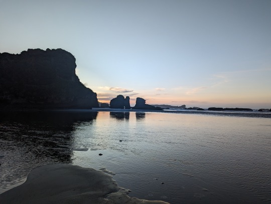
Sunset on Cape Foulwind, NZ OC (3000 x 4000)
7 notes
·
View notes
Text
Neuseeland Tag 12 🇳🇿
Nach einer relativ kalten Nacht 🥶 in der noblen Lodge (die Neuseeländer haben es nicht so mit Heizen/Isolieren/Klimaschutz) hat die Sonne ☀️ zum Glück nicht lange auf sich warten lassen und hat die 'german snails' 🐌 aus ihrem Häuschen geholt, um den eigenen Energiehaushalt erstmal wieder auf Vordermann zu bringen. The same precedure as every day: Frühstücken, Packen und Check Out. 💳 Der Highway 6️⃣ führte uns dann zum Cape Foulwind an der Westküste, an dem wir eine Kolonie Pelzrobben besuchten 🦭🤩 und den mächtigen meterhohen Wellen lauschten. Beim Stomern 📸🚶🏻♀️am Strand entdeckte ich sogar noch einen kleinen blauen Zwergpinguin 🐧 in einer Felshöhle. Der Tag hatte sich schon gelohnt, dachten wir. 🥳 Weiter gings die Westküste entlang Richtung Süden. Next Stop 🛑: die Pancake Rocks. Frei von jeglichen Erwartungen fiehlen wir dort erstmal zum Lunch ein und wurden von 2 deutschen Gastwirten begrüßt, bei welchen wir dann Cappuccino und 'so ein großen Klops aus der Vitrine' zu uns nahmen.... lecker 😅😋 Nun aber los zu den 'langweiligen' Felsen. Durch ein kurzes, recht gepflegtes Dschungelstück 🌴 gelangen wir zur Klippe und zu den wirklich mächtigen 🥞-Felsen, an denen sich ununterbrochen die riesigen Wellen brachen. 🌊 Was für eine Schauspiel! Wir staunten und fühlten uns im gleichen Moment ziemlich klein und verletzlich bei solchen kraftvollen Naturgewalten. 🤩 Völlig geflasht verließen wir diesen wunderbaren Ort und fuhren das letzte Stück unserer insgesamt ca 270km langen Tagesstrecke nach Greymouth, wo unsere heutiges Backpackerhostel mit bequemen Bett 🛌 auf uns wartete. Der krönenden Abschuss des erlebnisreichen Tages war jedoch der phänomenale Sonnenuntergang am Southern Breakwater ViewingPoint der Stadt bei "very rough sea". 😍🌅 Was für ein Tag!
Enjoy and stay tuned. ✌🏻😎


6 notes
·
View notes
Text


25.12.19
Umzug nach Westport. Reisetag und trotzdem sind wir am Zielort noch eine 2h Wanderung am Cape Foulwind gemacht und dort eine Seelöwen–Kolonie beobachtet.
Manchmal wussten wir nicht in welchem Land wir unterwegs sind.... Schottland, Kanaren oder doch etwa im Schwarzwald. Grübel. Nur das Meer so in der Nähe, lässt vermuten, in welcher Region wir unterwegs sind.
Merry Christmas, auch hier steht die Welt still.
5 notes
·
View notes
Text


Dimanche 10/11/2019 : Cape Foulwind
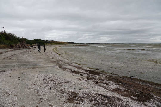
A 10km de Westport, se trouve le Cape Foulwind. Avec ce temps, nous n’avons pas pu partir trop longtemps marcher mais nous avons pu voir pleins d’oiseaux sur la petite île au loin. Il y a aussi des pingouins bleus ici, nous n’avons pas eu la chance d’en voir.
Par contre nous avons vu une colonie de phoques! Des vrais pantouflards ces phoques, ils faisaient la sieste sur les rochers malgré la pluie.
Le jeu c’est de les distinguer au milieu des rochers quand ils ronflent.
6 notes
·
View notes
Text


Lundi 27 janvier
Direction les seals colony et le phare du cap Foulwind.
1 note
·
View note
Text
Crossing to South Island
From Wellington we took the ferry across to Picton on the South Island and have spent a few days in Richmond near Nelson right in the north of the island. Both of us have come down with colds and are rather sniffly but we still managed to get out and about to the north to Farewell Spit and also over to the west coast to see the wonderfully named Cape Foulwind where we watched NZ fur seals playing in rockpools. It was quite a relaxing time which was needed given our colds.
We had anticipated going to vineyards whilst in this area but to be honest, given the amount of wine and vineyards we have already been to and taking paracetamol meant we didn't bother but enjoyed the scenery and countryside more.
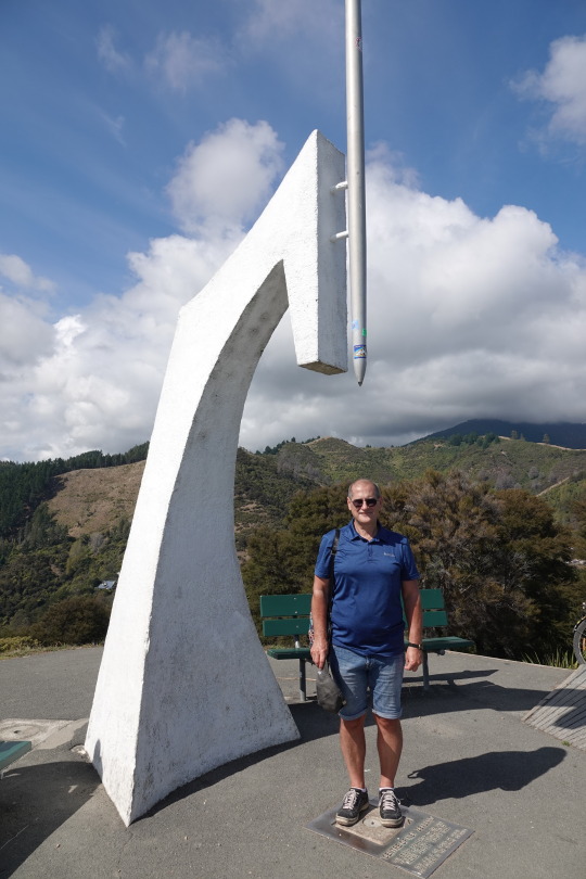
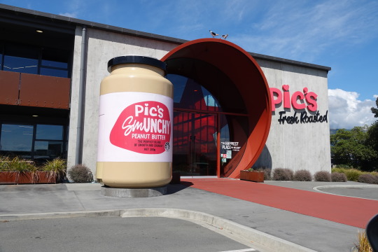
We also went around Nelson, visiting the peak which is the centre of NZ (flipping hard climb up) and also seeing the famous Pic's peanut butter factory 100% peanuts but sadly it was closed over the weekend so we didn't have a chance to visit - we cheated and bought some in the supermarket!
Off south now to Hanmer Falls and then Christchurch.
0 notes
Text


LAKE MAHINAPUA - HOKITIKA - PUNAKAIKI - WESTPORT - MOTUEKA_Tag 40-42
Das Ziel war dieses Mal klar. Der Parkplatz des Pororari River Tracks in Punakaiki, hier wollten wir bewährtermaßen die nächste Nacht frei stehen. Davor auf dem Weg in Hokitika lecker frühstücken und in Greymouth unser Zuhause wieder auf Vordermann bringen, sprich altes Wasser raus, neues rein und tanken. Es lief alles nach Plan, bis zu dem Schild in Punakaiki “no overnight staying”. Das gab es 2016 noch nicht. Gut, dass direkt nebenan ein sehr netter Campsite war und die Wäsche auch wieder gewaschen werden wollte. So standen wir zwei Nächte schön direkt am Meer auf einer grünen Wiese.


Der Tag war super. Erst gemütlich aufstehen und unter blauem Himmel frühstücken, ausgiebig mit Jona spielen und Wäsche waschen. Dann ging es die wunderschöne Wanderung am Fluss entlang. Für Verena als etwas weiteren Rundweg und für die Männer ab ca. der Hälfte auf gleichem Weg zurück. Abends dann wie vor vier Jahren in der Bar um die Ecke essen. So waren alle mehr als zufrieden. Und das bei bestem Wetter.

Heute hieß es dann Fahrtag, was mit Jona wunderbar geht. Einfach ein Reisekind. Wir haben in knapp 4,5 Stunden etwa 300 km geschafft. Erst einmal galt es, die unfassbar schöne Küste zu genießen - man fährt hier größtenteils direkt am Meer entlang, passiert unzählige menschenleere Buchten, oftmals gerahmt von bizarren Felsformationen und umgeben von satten Tropenwäldern. Unterwegs gab es neben diversen Fotostopps Pausen an der schon bekannten, aber ganz zauberhaften Tauranga Bay - um die Ecke kann man noch einer Seehundkolonie guten Tag sagen -, am Cape Foulwind, zur Nahrungsbeschaffung in Westport und zur Fütterung des jüngsten Teammitglieds am Buller River. Da wir den nett gelegenen Picknickspot allerdings mit jeder Menge Sandflies teilen mussten, wurde trotz Sonnenschein indoor gespeist.


Nun nächtigen wir 20 km vor Motueka auf einem Free Campsite direkt am Fluss. Nur mal zum Vergleich, wie die Nachbarschaft sich vom offiziellen Campingplatz unterscheidet: Gestern ausschließlich größere Camper in unserer Klasse neben uns, heute stehen hier nur zwei dieser Kategorie. Die anderen ca. 20 Fahrzeuge sind nahezu alles alte umgebaute Vans, die sich Abiturienten und Studenten kaufen und damit durchs Land reisen. Jona und wir finden beides super. Und da sich die Eltern ja sehr jung fühlen, fallen wir eigentlich nur wegen des kleinen Mannes etwas aus der Reihe.
Morgen geht es dann weiter zum Abel Tasman National Park. Definitiv auch ein Ort, der sich zwei Besuche verdient hat.
1 note
·
View note
Text
time shift and time change
time>time shift germany new zealand>/days>You get off the plane and your daily rhythm is upside down. Your body will need a few days, maybe even one or two weeks to get used to the time difference between New Zealand and Germany. This is quite normal, unfortunately you can't accelerate or skip this process. Nevertheless, there are some tips and tricks that can make it a little easier for you to get over your jet lag. staging), the usual intake time must not be exceeded by more than three hours, i.e. the interval between two dragées must not exceed 27 hours. However, you will usually already be informed of the current time by the crew when approaching New Zealand. There is no problem with mobile phones, as most of them automatically recognize the time zone. A popular sight in Berlin also deals with time zones - the world time clock at Alexanderplatz. It consists of a cylinder with 24 corners, on which the respective time zones can be found. Thanks to a rotating hour ring, the most important cities in each zone are also incorporated into the aluminium plates. The clock was installed in September 1969 and has been one of the "buildings worthy of protection in the country" since 2015.
Join in
The different cultures and ways of life brought many conflicts with the Maori, which were to be solved by the "Treaty of Waitangi". Today this treaty is called the founding document of New Zealand. New Zealand is not only the emigration country but also the holiday country par excellence. There is hardly anyone who does not plan to travel to the "end of the world" once in a lifetime and experience the country's sweet and rough beauty at the same time. Come with us and discover Marlborough and Milford Sound, Cape Foulwind, Mount Cook and the Fox Glacier on one of the New Zealand tours of Intakt-Reisen.
In addition, some states along the dateline decided to spend some time on the other side of the dateline.
That means, if it is 10 o'clock in the morning in Germany, it is already 9 o'clock in the evening of the same day in New Zealand.
> They have been researched and prepared to the best of our knowledge and belief.

Auckland Airport (AKL)
Read more about campervan hire New Zealand here. In addition, some states along the dateline have chosen a time on the other side of the dateline. There are therefore two additional time zones, UTC+13 and UTC+14. There are also more than 24 time zones, as some states have chosen a time that is not a full hour different from UTC. The national team is nicknamed All Blacks and has won the Rugby World Cup several times. In Germany the New Zealanders Peter Jackson (director of the movie "Lord of the Rings") and Wynton Rufer (former footballer at Werder Bremen) are well known.
1 note
·
View note
Photo

«No exit before Tasmania» When the Europeans started exploring what we now call New Zealand, they obviously had seen a lot in a shorg time. And they were runninb out og grandieous names. So, Cape Foulwind, where the weather on the westernmost point in South Island was chalkenging back in the days too. The old mining town of Westport is a useful base for exploring this area. Being of architectural interest itself, the sea, land snd mountains carries views and sights worth it. Like a fursealcolony, hiing tracks along the coast, beaches, sea and wind! And spots of very loud cricket concerts by sunset! https://en.m.wikipedia.org/wiki/Cape_Foulwind #tasmania #westport #westcoast #southisland #newzealand #New #Zealand #kiwi #foulwind #sea #roadtrip #2016 #tasmaniansea #mobile #LGG4 #LG #G4 #smartphone #sun #trekking #hiking #farmland #furseal #seal #wave (ved Cape Foulwind Lighthouse) https://www.instagram.com/p/BM8uS6uglQd/?igshid=oj6y3alfhlnb
#tasmania#westport#westcoast#southisland#newzealand#new#zealand#kiwi#foulwind#sea#roadtrip#2016#tasmaniansea#mobile#lgg4#lg#g4#smartphone#sun#trekking#hiking#farmland#furseal#seal#wave
0 notes
Text
General Information New Zealand Travel NZdirect
Auckland on the North Island is home to New Zealand's most important airport. The big city of Auckland itself is situated in a picturesque location at various sea bays and has numerous parks with subtropical vegetation. Read more about campervan hire New Zealand here.
The New Zealand autumn: March to May
Until the 19th century, every place had its own so-called "true local time", which was based on the sun. Depending on the degree of longitude, therefore, the times differed from place to place. {
Flight times of fifteen hours or more are not uncommon for long-distance travel.the gastro-intestinal complaints occur repeatedly, the effectiveness of the pill is no longer guaranteed.
>> For this reason I recommend the summer months for the remaining regions on the North Sea island and Wellington as the best time to travel in New Zealand. The primary journalistic mission of The Weather Company is to report on weather and climate phenomena and the importance of science for our everyday lives. This content does not necessarily reflect the position of our parent company IBM. Of course, the division into different time zones has not always existed. Thanks to a rotating hour ring, the most important cities in each zone or area are also incorporated into the aluminium plates. Today this contract is called the founding document of New Zealand. New Zealand is not only the emigration country but also the holiday country par excellence. There is hardly anyone who does not plan to travel to the "end of the world" once in a lifetime and experience the country's sweet and rough beauty at the same time. Come with us and discover Marlborough and Milford Sound, Cape Foulwind, Mount Cook and the Fox Glacier on one of the New Zealand tours of Intakt-Reisen. So if the time difference is no more than 12 hours, you can take the pill at home and at your holiday destination at your usual time.

1 note
·
View note
Photo

Three Steeples at Cape Foulwind (NZ) [OC] [2038x1365]
5 notes
·
View notes
Text
LOTD: Isola di Mal di Ventre
(from: http://www.ibiblio.org/lighthouse/sar.htm)
Isola di Mal di Ventre
Date unknown. Active focal plane 26 m (85 ft); flash every 6 s, white or red depending on direction. 8 m (26 ft) post atop a square 1-story equipment shelter. Lighthouse painted white. The Navy has a page for the lighthouse, Trabas has Eckhard Meyer's distant view, and Google has a satellite view. The Isola di Mal di Ventre (the name means Foulwind Island) is a low, dangerous island about 1.8 m (1.1 mi) long surrounded by rock reefs. Located about 10 km (6 mi) west southwest of Porto Mandriola. Accessible only by boat. Site open, tower closed. ARLHS SAR-003; EF-1402; Admiralty E1111; NGA 8316.

(full photo found here; ©Eckhard)
0 notes