#belize
Explore tagged Tumblr posts
Text

guy who gets into trends late -> BELIZEAN MIKU YAAYYYY
#artperhaps#hatsune miku#miku#miku hatsune#vocaloid#vocaloid miku#international miku#miku worldwide#or whatever they're calling it idek#belize#belizean miku
5K notes
·
View notes
Text

~ Eccentric Flint in the Form of a Scorpion.
Place of origin: Belize, Guatemala, Honduras, or Mexico (Mesoamerica)
Culture: Maya
Date: A.D. 600–900
Medium: Stone, Chert
#7th century#10th century#flint#eccentric flint#scorpion#mesoamerica#maya#mexico#belize#guatemala#honduras#stone#chert#a.d. 600#a.d. 900#history#museum#archeology#archaeology
6K notes
·
View notes
Text

Jodi DeGerlia, belize (2009)
from here
213 notes
·
View notes
Text

belizean miku? belizean miku
#hatsune miku#belizean miku#belize#miku hatsune#i really wanted to hop on this trend and i saw a couple of caribbean miku's and that made me happy#caribbean
248 notes
·
View notes
Text
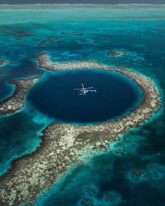
By Emmett_Sparling
Great Blue Hole, Belize
#curators on tumblr#belize#sea#ocean#blue#aerial#landscape#nature#central america#north america#travel#great blue hole#emmett sparling
608 notes
·
View notes
Text


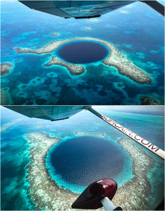


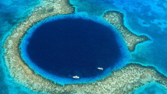




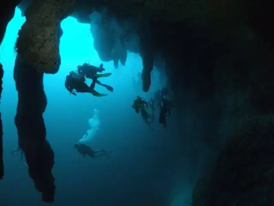

Большая голубая дыра находится в водах на территории государства Белиз. Поскольку данное углубление самое большое среди подобных, ЮНЕСКО внесло ее в перечень всемирного наследия, которое подлежит охране. Большая голубая дыра - круглая воронка правильной формы на дне океана, которая образовалась естественным путем. Ее диаметр 305 м, а глубина – 120 м. Учетные связывают ее образование с затоплением системы известняковых пещер, произошедшем при поднятии океана после последнего ледникового периода. Со временем их своды обвалились, и образовалась воронка.
До сравнительно недавнего времени существовала более романтичная версия ее образования. Якобы это огромный сосуд, в котором люди древних цивилизаций хранили что-то весьма ценное. Этот миф развеял Ж.-И. Кусто, который подтвердил теорию естественного образования дыры.
Это место очень любят дайверы: оно входит в 10 лучших мест для такого рода активностей. Чтобы совершить погружение, надо проплыть 96 км, что займет до 2 часов, поэтому сюда надо добираться на катере. Их прокат в местном порту Сан-Педро очень популярная услуга. Погружаясь в кратер, любители приключений могут посетить затопленные пещеры со сталактитами и сталагмитами. Нужно быть очень осторожными: система пещер весьма запутанная и легко можно заблудиться: второе, неофициальное, название, которое заслужило это место – Кладбище дайверов.
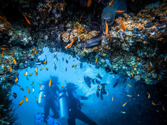
Тем, кому интересна фауна, а также ныряльщикам с недостаточным опытом погружения, стоит оставаться в относительной близости к поверхности, где рыбы ведут активный образ жизни. Этот слой не превышает 30 метров. В воде можно наблюдать за морскими черепахами, безобидными акулами-няньками, груперами, морскими окунями и другими более мелкими рыбами. Такая глубина вполне комфортна для ныряльщиков – температура не опускается ниже 24 °C.
На нее стоит посмотреть с высоты: завораживающее зрелище. Поэтому для состоятельных туристов устраивают вертолетные экскурсии. А для совсем экстремалов – прыжок с парашютом над Дырой.
The Great Blue Hole is located in the waters of the state of Belize. Since this depression is the largest of its kind, UNESCO has included it in the list of world heritage sites that are subject to protection. The Great Blue Hole is a round funnel of regular shape on the ocean floor, which was formed naturally. Its diameter is 305 m, and its depth is 120 m. Accountants associate its formation with the flooding of a system of limestone caves, which occurred when the ocean rose after the last ice age. Over time, their arches collapsed, and a funnel was formed.
Until relatively recently, there was a more romantic version of its formation. Allegedly, this is a huge vessel in which people of ancient civilizations kept something very valuable. This myth was dispelled by J.-Y. Cousteau, who confirmed the theory of the natural formation of the hole.
This place is very popular with divers: it is among the 10 best places for this kind of activity. To dive, you need to swim 96 km, which will take up to 2 hours, so you need to get here by boat. Their rental in the local port of San Pedro is a very popular service. Diving into the crater, adventure lovers can visit flooded caves with stalactites and stalagmites. You need to be very careful: the cave system is very confusing and it is easy to get lost: the second, unofficial, name that this place has earned is the Divers' Cemetery.
Those who are interested in fauna, as well as divers with insufficient diving experience, should stay relatively close to the surface, where the fish lead an active lifestyle. This layer does not exceed 30 meters. In the water, you can observe sea turtles, harmless nurse sharks, groupers, groupers and other smaller fish. This depth is quite comfortable for divers - the temperature does not fall below 24 ° C.
It is worth looking at it from above: a fascinating spectacle. That is why helicopter excursions are arranged for wealthy tourists. And for the most extreme ones – a parachute jump over the Hole.
Источник://megapozitiv.com/bolshaja-golubaja-dyra-beliz-foto-interesnye-fakty-video.html,/tourweek.ru/gallery/sight/great-blue-hole/latest,/planetofhotels.com/guide/ru/beliz/beliz-siti/bolshaya-golubaya-dyra,/pogovorim.by/19122-bolshaya-golubaya-dyra-bereg-beliz-karibskoe-more-nauka-zhak-kusto.html,/omyworld.ru/6385.
#Belize#nature#atoll#ocean view#Great Blue Hole#diving#landscape photography#ocean#reef#corals#fish#clouds#sunset#boats#nature aesthetic#underwater photos#Белиз#природа#пейзаж#атолл#природнаякрасота#Большая голубая дыра#дайвинг#океан#риф#кораллы#рыбы#небо#закат#подводные фото
201 notes
·
View notes
Note
Can I request an ocellated turkey please


#central american bird#central america#yucatan peninsula#mexico#belize#guatemala#birds#birding#animal polls#my polls#poll blog#animals#polls#tumblr polls#bird#turkey#ocellated turkey
372 notes
·
View notes
Text

Caye Caulker, Belize District, Belize
124 notes
·
View notes
Text
"The world’s coral reefs are close to 25% larger than we thought. By using satellite images, machine learning and on-ground knowledge from a global network of people living and working on coral reefs, we found an extra 64,000 square kilometers of coral reefs — an area the size of Ireland.
That brings the total size of the planet’s shallow reefs (meaning 0-20 meters deep) to 348,000 square kilometers �� the size of Germany. This figure represents whole coral reef ecosystems, ranging from sandy-bottomed lagoons with a little coral, to coral rubble flats, to living walls of coral.
Within this 348,000 km² of coral is 80,000 km² where there’s a hard bottom — rocks rather than sand. These areas are likely to be home to significant amounts of coral — the places snorkelers and scuba divers most like to visit.
You might wonder why we’re finding this out now. Didn’t we already know where the world’s reefs are?
Previously, we’ve had to pull data from many different sources, which made it harder to pin down the extent of coral reefs with certainty. But now we have high resolution satellite data covering the entire world — and are able to see reefs as deep as 30 meters down.
We coupled this with direct observations and records of coral reefs from over 400 individuals and organizations in countries with coral reefs from all regions, such as the Maldives, Cuba and Australia.
To produce the maps, we used machine learning techniques to chew through 100 trillion pixels from the Sentinel-2 and Planet Dove CubeSat satellites to make accurate predictions about where coral is — and is not. The team worked with almost 500 researchers and collaborators to make the maps.
The result: the world’s first comprehensive map of coral reefs extent, and their composition, produced through the Allen Coral Atlas.
The maps are already proving their worth. Reef management agencies around the world are using them to plan and assess conservation work and threats to reefs...
In good news, these maps are already leading to real world change. We’ve already seen new efforts to conserve coral reefs in Indonesia, several Pacific island nations, Panama, Belize, Kenya and Australia, among others."
-via GoodGoodGood, May 2, 2024
--
Note: You can see the maps yourself by going here!
#coral#coral reef#sea creatures#marine life#underwater#coral reefs#conservation#conservation news#climate change#hope#hope posting#hopepunk#environment#environmental science#environmental news#good news#climate action#climate hope#maldives#cuba#australia#machine learning#ai#this is the kind of shit ai should be used for!!!#indonesia#panama#belize#kenya#it's coral week here at reasonsforhope and it's not even on purpose!
294 notes
·
View notes
Text

following my dreams and drawing Belizean Miku as some regular chilling on an almond tree

#artperhaps#vocaloid#vocaloid miku#miku#belize#miku worldwide#miku hatsune#hatsune miku#belizean miku#international miku#fun fact: based on pictures my friends and i took a few years ago
564 notes
·
View notes
Text

Is it a big kitty or a big bread loaf?
Jaguar (Panthera onca)
Southern North America and Northern-central South America
Status: Near Threatened (IUCN); Endangered in USA and Mexico; protected in Brazil
#jaguar#panthera onca#feline#big cat#mammal#cat art#wild cat#feline art#conservation#north america#south america#brazil#paraguay#bolivia#columbia#venezuela#guyana#surinam#ecuador#panama#costa rica#nicaragua#guatemala#honduras#mexico#usa#belize
64 notes
·
View notes
Photo

The Maya Civilization flourished between 250-950 although it drew upon earlier civilizations such as that of the Olmecs (1500 - 200 BCE) and Zapotec (600 BCE - 800 CE) and lasted through the Post-Classic Period of 950-1524. The great cities of the Maya were abandoned during this latter period, prior to the Spanish Conquest of the region. This gallery presents 40 images of some of those cities, both the famous and the lesser-known sites.
159 notes
·
View notes
Text

Xunantunich, San Jose Succotz, Belize: Xunantunich is an Ancient Maya archaeological site in western Belize, about 70 miles west of Belize City, in the Cayo District. Xunantunich is located atop a ridge above the Mopan River, well within sight of the Guatemala border – which is 0.6 miles to the west. Wikipedia
152 notes
·
View notes

