#Shasta-Trinity National Forest
Explore tagged Tumblr posts
Visit Tumblr Blog
Explore Tumblr blogs with no restrictions, modern design and the best experience.
Last Seen Tumblr Blogs


Fun Fact
There were a total of 171.5 billion posts on Tumblr in 2019.
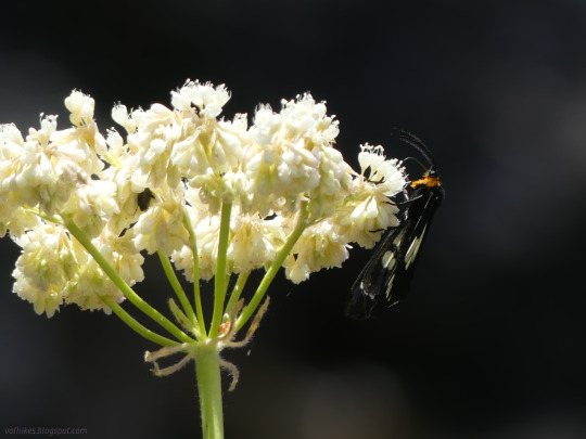
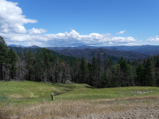
Text


Shasta-Trinity National Forest, California
Day 2 backpacking South Fork was actually spent on Smoky Creek where the Bigfoot Trail climbs away from the river. I hiked up to the trailhead, getting in some views, before returning to the river.
#hiking#nature#landscape#travel#hike#outside#California#Trinity County#Trinity National Forest#Shasta-Trinity National Forest#National Recreation Trail#NRT#backpacking#forest#river#Bigfoot Trail#South Fork Trinity National Recreation Trail#South Fork Trinity River Trail#South Fork Trinity River
6 notes
·
View notes
Text
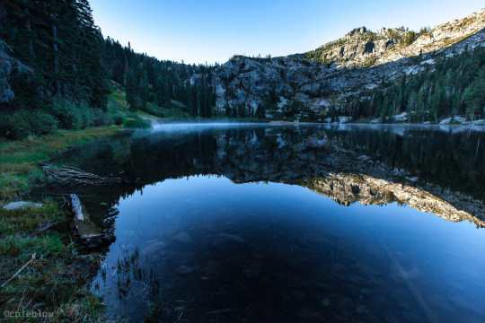
tangle blue lake (shasta-trinity national forest)
©cpeblow (2015)
#landscape#shasta national forest#trinity alps#back packing#camping#hiking#dawn#reflections#still water#shasta-trinity
68 notes
·
View notes
Text


Mount Shasta, CA
Mount Shasta is a potentially active volcano at the southern end of the Cascade Range in Siskiyou County, California. At an elevation of 14,179 ft (4,322 m), it is the second-highest peak in the Cascades and the fifth-highest in the state. Mount Shasta has an estimated volume of 85 cubic miles (350 cubic kilometers), which makes it the most voluminous stratovolcano in the Cascade Volcanic Arc. The mountain and surrounding area are part of the Shasta–Trinity National Forest.
The origin of the name "Shasta" is vague, either derived from a people of a name like it or otherwise garbled by early Westerners. Mount Shasta is connected to its satellite cone of Shastina, and together they dominate the landscape. Shasta rises abruptly to tower nearly 10,000 feet (3,000 m) above its surroundings. On a clear winter day, the mountain can be seen from the floor of the Central Valley 140 miles (230 km) to the south. The mountain has attracted the attention of poets, authors, and presidents.
The mountain consists of four overlapping dormant volcanic cones that have built a complex shape, including the main summit and the prominent and visibly conical satellite cone of 12,330 ft (3,760 m) Shastina. If Shastina were a separate mountain, it would rank as the fourth-highest peak of the Cascade Range (after Mount Rainier, Rainier's Liberty Cap, and Mount Shasta itself).
Mount Shasta's surface is relatively free of deep glacial erosion except, paradoxically, for its south side where Sargents Ridge runs parallel to the U-shaped Avalanche Gulch. This is the largest glacial valley on the volcano, although it does not now have a glacier in it. There are seven named glaciers on Mount Shasta, with the four largest (Whitney, Bolam, Hotlum, and Wintun) radiating down from high on the main summit cone to below 10,000 ft (3,000 m) primarily on the north and east sides. The Whitney Glacier is the longest, and the Hotlum is the most voluminous glacier in the state of California. Three of the smaller named glaciers occupy cirques near and above 11,000 ft (3,400 m) on the south and southeast sides, including the Watkins, Konwakiton, and Mud Creek glaciers.
Source: Wikipedia
#Volcanic Legacy Scenic Byway#travel#original photography#vacation#tourist attraction#landmark#landscape#countryside#Shasta County#USA#California#summer 2023#flora#nature#forest#woods#tree#view#Westcoast#Cascade Range#Mount Shasta#street scene
23 notes
·
View notes
Video

flickr
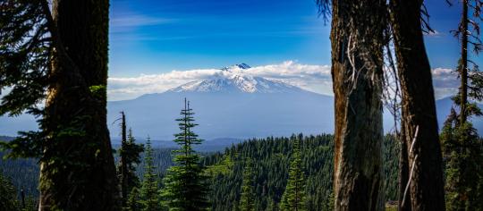
Fresh Ideas for Travel in Shasta–Trinity National Forest by Mark Stevens Via Flickr: A setting looking to the northeast and taking in views across a picturesque setting in Shasta-Trinity National Forest. This was while along the Heart Lake Trail From Castle Lake. What drew me into the setting wasn't just seeing Mount Shasta as it came from behind the nearby peak, but also the layered look with one peak after the other. The rest of the image composition was aligning myself to bring out more of a balanced look between the two peaks, as well as the nearby evergreen forest with the trees scattered about.
#Azimuth 31#Blue Skies#California Cascades#Cascade Range#Day 4#DxO PhotoLab 8 Edited#Evergreen Trees#Evergreens#Forest#Forest Landscape#Heart Lake Trail From Castle Lake#Hillside of Trees#Klamath Mountains#Landscape#Landscape - Scenery#Lassen Volcanic Shasta Napa#Looking NE#Mount Shasta#Mount Shasta Area#Mountain Peak#Mountains#Mountains in Distance#Mountains off in Distance#Mountainside#Nature#Nikon Z8#No People#Northwest U.S. Coast Ranges#Outside#Pacific Ranges
3 notes
·
View notes
Text
-- OH, SO MANY WAYS HE FELT OLD AND TOO YOUNG IN THIS MOMENT. Just finished a shift scrubbing dishes at the Old Shasta for a wad of cash. Managed to pick up a few new phrases in Spanish and Jamaican. Taught Chef Z how to whistle danger coming in his own native tongue: the whistle-code that carried through the old choke-cherry trees on a hunter's moon.
There's the moment, out here in the world, off the mountain. The smog in the air and the neon signs buzzing and the footsteps on concrete, it's noise and chaos and a buzzing energy beneath his skin. The grizzled old hermit had never been one to trust strangers, he wasn't naive and far from innocent, just a bit-- sheltered, there in that snowy homestead his entire life.
The stubbornness of an old dog forced to learn new tricks. In his fifties going from yeh can't get there from heah to learning how to use public transit. Learning how to navigate a crowded kitchen, learning to tolerate the way that everything was so bright and, god the lack of stars that made the night a navy-green void. That lack of stars hadn't stopped bugging him, made him feel adrift without Orion to help him know the safe path home.
Closing time. It was nice, having people call as he shut the door. Could almost pretend the Mad Dogs were back, heard Chef Z whistle out a mangled blessing-song as Jack trudged to the dumpster with a few last broken plates. Wasn't sure if hearing the blessing-song used that was was comforting or ominous. At least they were trying, with the scant few details the old hermit gave anyone about who he was.
The alley was dark, the lightbulb burnt out or broken. Jack sighed, looked over his shoulder and took his sunglasses off. Orange embers lit within his eyes as he blinked the shadows away. The alley became clear as day, if slightly grayscale.
There was a third glowing ember around his eye-level, someone sparking a cigarette. A smell of blood in the air, thick and copper. This city was too damn hot-- the smell of blood was supposed to be clear-cut with the ice and snow, not this humid lingering.
Fiddlers don't meddle in human affairs. That's what he'd grown up on. Rules were rules, hadn't he said that so many times? He was only supposed to be here for a few weeks. Checking out the Shasta Trinity National Forest for yew trees, nothing more.
Following the rules had gotten him nothing but trouble before, hadn't it? Not meddling in human matters. But, the scene before him was anything but human. Looked almost like a bear attack. Claws were claws, and he wasn't keen to get closer.
Then the other man looked up lazily, regarded his presence. The old Mad Dog felt his hackles raise, bit the inside of his cheek. The man nabbed the pack of cigarettes again and held them up, offering one. Jack had never been a smoker but... Curiosity killed the cat, might as well kill the Dog too.
He took a wary step closer, hit with another wave of that shimmering too-humid blood. He dropped the half-broken plate and plucked the cigarette and held it. Bent close as the man lit it.
Saw the man's eyes glint yellow in the flame. It was no trick of the light. Six points of warm light hung in the dark blue-grey alley; Jack's orange embers, the two red-orange cigarettes, and the stranger's golden eyeshine.
Jack bit down the questions and simply straightened back up. He nodded in thanks. Glanced down at the body.
At the very least, he was stuck here until the cigarette was done. Rules were rules, right?
"Seems like you've had a hell of a night." Tried to keep his voice casual.
// @zoanthropiic
#the oldest trees above my head ;;#this got long because Jack felt like rambling you DON'T have to match it !!!#jack is having feelings about How Much He Hates The City sorry
1 note
·
View note
Photo
Mount Shasta from the Pacific Crest Trail. Shasta-Trinity National Forest, California, USA. [4782 x 2090] [OC]
6 notes
·
View notes
Photo

☺️ Don't hide behind social analytic tools... Be social! 😄 #marketing #SocialMedia #SocialMediaMarketing (at Shasta–Trinity National Forest) https://www.instagram.com/p/CpfgW4_LwGA/?igshid=NGJjMDIxMWI=
4 notes
·
View notes
Photo

Weather: Pacific Northwest
Report generated at 2025-02-03 12:00:08.481302-08:00 using satellite imagery and alert data provided by the National Weather Service.
Cold Weather Advisory
WA:
North Coast
San Juan County
Western Strait of Juan De Fuca
Western Whatcom County
Winter Weather Advisory
WA:
Central Coast
Clatsop County Coast
East Puget Sound Lowlands
Eastern Strait of Juan de Fuca
Hood Canal Area
Lower Chehalis Valley Area
North Coast
North Oregon Coast Range Lowlands
San Juan County
South Washington Coast
Southwest Interior
Tacoma Area
Tillamook County Coast
Western Skagit County
Western Strait of Juan De Fuca
Western Whatcom County
Willapa and Wahkiakum Lowlands
OR:
Camas Prairie
Clatsop County Coast
Eastern Curry County and Josephine County
Jackson County
Malheur County
North Oregon Coast Range Lowlands
Ochoco-John Day Highlands
South Washington Coast
Tillamook County Coast
Upper Weiser River
Willapa and Wahkiakum Lowlands
ID:
Camas Prairie
Central Panhandle Mountains
Eastern Lemhi County
Lewis and Southern Nez Perce Counties
Malheur County
Orofino/Grangeville Region
Upper Weiser River
Western Lemhi County
CA:
Burney Basin / Eastern Shasta County
Central Siskiyou County
Mountains Southwestern Shasta County to Western Colusa County
Northern Humboldt Interior
Shasta Lake Area / Northern Shasta County
Southern Humboldt Interior
Southern Trinity
Winter Storm Warning
WA:
North Oregon Coast Range
Willapa Hills
OR:
Boise Mountains
Central and Eastern Lake County
Harney County
Jackson County
Klamath Basin
North Oregon Coast Range
Northern and Eastern Klamath County and Western Lake County
Owyhee Mountains
Siskiyou Mountains and Southern Oregon Cascades
South Central Oregon Cascades
West Central Mountains
Willapa Hills
ID:
Big Hole Mountains
Big Lost Highlands/Copper Basin
Bitterroot/Sapphire Mountains
Boise Mountains
Centennial Mountains/Island Park
Frank Church Wilderness
Harney County
Northern Clearwater Mountains
Owyhee Mountains
Sawtooth/Stanley Basin
Southern Clearwater Mountains
Sun Valley Region
Teton Valley
West Central Mountains
Wood River Foothills
CA:
Del Norte Interior
Eastern Sierra Slopes of Inyo County
Greater Lake Tahoe Area
Kaiser to Rodgers Ridge
Kings Canyon NP
Lassen-Eastern Plumas-Eastern Sierra Counties
Modoc County
Mono
North Central and Southeast Siskiyou County
Northeast Siskiyou and Northwest Modoc Counties
Northern Trinity
Sequoia NP
South Central Siskiyou County
South End of the Upper Sierra
Upper San Joaquin River
West Slope Northern Sierra Nevada
Western Plumas County/Lassen Park
Western Siskiyou County
Yosemite NP outside of the valley
NV:
Greater Lake Tahoe Area
Freeze Warning
OR:
Curry County Coast
South Central Oregon Coast
Avalanche Warning
ID:
Big Hole Mountains
Big Lost Highlands/Copper Basin
Boise
Caribou Range
Centennial Mountains/Island Park
Sawtooth/Stanley Basin
Sun Valley Region
Teton Valley
Wood River Foothills
Wind Advisory
CA:
Carquinez Strait and Delta
Central Sacramento Valley
Coastal North Bay Including Point Reyes National Seashore
Eastern Sierra Slopes of Inyo County
Marin Coastal Range
Motherlode
Northeast Foothills/Sacramento Valley
Northern Monterey Bay
Northern Sacramento Valley
Northern San Joaquin Valley
Owens Valley
San Francisco
San Francisco Peninsula Coast
Santa Cruz Mountains
Santa Lucia Mountains and Los Padres National Forest
Southern Monterey Bay and Big Sur Coast
Southern Sacramento Valley
NV:
Humboldt County
Northeastern Nye County
Northern Lander County and Northern Eureka County
Northwestern Nye County
Ruby Mountains and East Humboldt Range
South Central Elko County
Southern Lander County and Southern Eureka County
Western Nevada Basin and Range including Pyramid Lake
White Pine County
Flood Advisory
CA:
Lassen
Sonoma
Flood Warning
CA:
Humboldt
Lassen
Modoc
Tehama
Flood Watch
CA:
Carquinez Strait and Delta
Central Sacramento Valley
Coastal North Bay Including Point Reyes National Seashore
East Bay Hills
East Bay Interior Valleys
Eastern Santa Clara Hills
Greater Lake Tahoe Area
Lassen-Eastern Plumas-Eastern Sierra Counties
Marin Coastal Range
Mariposa Madera Foothills
Mariposa-Madera Lower Sierra
Motherlode
Mountains Of San Benito County And Interior Monterey County Including Pinnacles National Park
Mountains Southwestern Shasta County to Western Colusa County
North Bay Interior Mountains
North Bay Interior Valleys
Northeast Foothills/Sacramento Valley
Northern Monterey Bay
Northern Sacramento Valley
Northern Salinas Valley/Hollister Valley and Carmel Valley
Northern San Joaquin Valley
San Francisco
San Francisco Bay Shoreline
San Francisco Peninsula Coast
Santa Clara Valley Including San Jose
Santa Cruz Mountains
Santa Lucia Mountains and Los Padres National Forest
Shasta Lake Area / Northern Shasta County
Sonoma Coastal Range
Southern Monterey Bay and Big Sur Coast
Southern Sacramento Valley
Southern Salinas Valley/Arroyo Seco and Lake San Antonio
West Slope Northern Sierra Nevada
Western Plumas County/Lassen Park
NV:
Greater Lake Tahoe Area
Lassen-Eastern Plumas-Eastern Sierra Counties
High Wind Warning
CA:
Greater Reno-Carson City-Minden Area
Mineral and Southern Lyon Counties
Mono
NV:
Greater Reno-Carson City-Minden Area
Mineral and Southern Lyon Counties
Mono
Lake Wind Advisory
CA:
Greater Lake Tahoe Area
NV:
Greater Lake Tahoe Area
Winter Storm Watch
CA:
Northern Humboldt Interior
Air Quality Alert
CA:
Calabasas and Agoura Hills
Catalina and Santa Barbara Islands
Eastern San Fernando Valley
Eastern Santa Monica Mountains Recreational Area
Los Angeles County Beaches
Los Angeles County Inland Coast including Downtown Los Angeles
Los Angeles County San Gabriel Valley
Malibu Coast
Orange County Coastal
Orange County Inland
Palos Verdes Hills
Riverside County Mountains
San Bernardino and Riverside County Valleys-The Inland Empire
San Gorgonio Pass Near Banning
Santa Clarita Valley
Santa Susana Mountains
Western San Fernando Valley
Western Santa Monica Mountains Recreational Area
0 notes
Text
https://www.mercurynews.com/2022/11/04/more-bay-area-rain-is-expected-this-weekend-could-it-bring-an-end-to-fire-season/
According to Cal Fire, crews have battled 7,211 wildfires in the state this year that have burned 362,351 acres, caused nine deaths, and destroyed 876 structures. The worst of those were the Mosquito Fire in Placer and El Dorado counties (76,788 acres, 78 structures destroyed, two firefighters injured) and the McKinney Fire in Siskiyou County (60,138 acres, 185 structures, four deaths, seven injuries).
In 2021, a far worse year, wildfires in California burned 2.57 million acres and destroyed 3,846 structures, according to Cal Fire records. The Dixie Fire in Butte, Plumas, Lassen, Shasta, and Tehama counties burned nearly 1 million acres. Five other fires cut through huge swaths of vegetation: The Monument Fire in the Shasta-Trinity National Forest (223,124 acres); the Caldor Fire in El Dorado County (221,835); the River Complex in the Klamath National Forest (199,359); the McFarland Fire in Trinity, Shasta and Tehama counties (122,653), and the Beckwourth Complex in the Plumas National Forest (105,670).
And 2020 was even worse: fires burned 4.3 million acres in the state, killing 33 people and destroying 11,116 buildings, according to Cal Fire records. Cal Fire crews battled 8,648 wildfires that year.
1 note
·
View note
Text

Lava Flows of the Sáttítla Highlands
Evidence of the fiery history of the Sáttítla Highlands in Northern California can be seen in every direction. Volcanism has shaped the landscape over the past million years, and remnants of lava flows and eruptions remain visible today.
At Sáttítla’s core rests a sleeping giant: the Medicine Lake Volcano, one of the two largest volcanoes in the Cascades Volcanic Arc. Intermittent, mostly effusive (non-explosive) eruptions built this large shield volcano. The volcano’s central caldera cradles its namesake Medicine Lake, one of the many volcanic features visible in this image, acquired on October 7, 2024, by the OLI (Operational Land Imager) on Landsat 8.
The volcano has erupted nine times in the last 5,000 years, and some of those began with explosive phases. For example, two of the most recent eruptions sent ash tens of miles downwind before a slow effusion of thick lava (obsidian) formed Little Glass Mountain and Glass Mountain about 1,000 years ago. Glass Mountain’s steep-sided rhyolite and obsidian flow spans 14 square kilometers.
The Indigenous Ajumawi name “Sáttítla” translates to “obsidian place,” and the highlands contain portions of the ancestral homelands of Indigenous communities. On January 7, 2025, over 224,000 acres of these highlands were designated as a U.S. national monument, including portions of the homelands of the Pit River (Ajumawi – Atsugewi) and Modoc Peoples (Mo Wat Knii – Mo Docknii).
The image shows bare lava fields interspersed with islands of vegetation and surrounded by green forests. Sáttítla Highlands National Monument encompasses parts of the Modoc, Shasta-Trinity, and Klamath national forests. The region is home to rare and vulnerable flora and fauna, including the Cascades frog, the northern spotted owl, the long-toed salamander, and the sugarstick—a parasitic plant associated with the roots of old-growth conifers.
Over 80 plant species found here are used by Indigenous communities for medicine, food, tools, and ceremonial purposes. Obsidian tools have been found within the area, which were crafted by Indigenous communities throughout the region.
NASA Earth Observatory image by Wanmei Liang, using Landsat data from the U.S. Geological Survey. Story by Emily Cassidy.
0 notes
Text

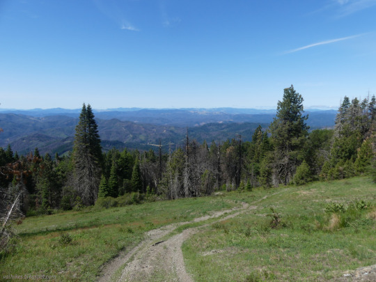
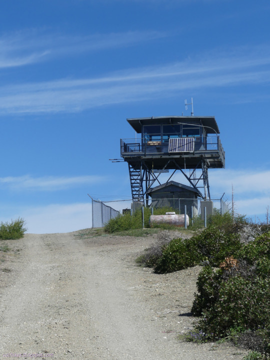
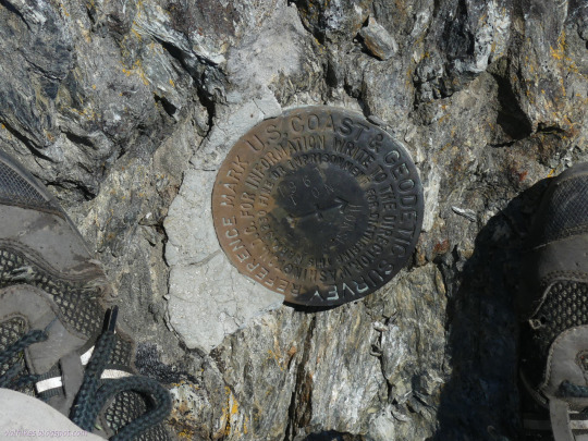
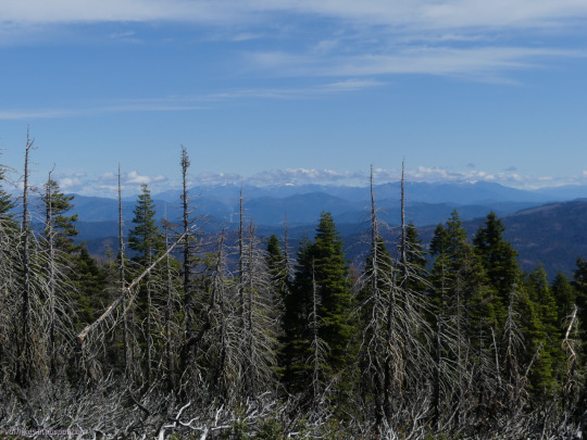


Six Rivers National Forest, California
Visiting the 4th, highest, and only still active fire lookout on South Fork Mountain. That makes all of them!
#hiking#dayhike#peakbagging#SixRiversNF#firelookout#Trinity County#California#landscape#nature#outside#ShastaTrinityNF#TrinityNF#travel#hike#day hike#mountains#Six Rivers National Forest#Trinity National Forest#Shasta-Trinity National Forest#wildlife#wildflowers#flowers#views#peakbagger
55 notes
·
View notes
Text
Discovering Joy in Aragog’s Hollow
In 2012, Sierra ‘Monkey’ Burror and her mother, Heather (’Mama Bear’), thru-hiked the PCT. When Sierra finished she was a mere 9 years old. But here hiking exploits were not done. This mother-daughter team hiked the Colorado trail in 2013 and completed the Continental Divide Trail during the following three summers. Sierra is now 17 and is finishing her senior year in high school. She will be attending Cornell University next year, where she will be running both cross country and track, and plans to study Ecology and Evolutionary Biology with a minor in Environmental Economics. This is a short piece from their PCT thru-hike.


By Sierra Burror
Even with my eyes squeezed shut tight, I could still sense the 472 spider legs as they slowly advanced up my purple nylon sleeping bag toward my head. After an exhausting, 20-mile day, the postage-stamp-sized patch of bare ground we now called home had seemed like a palace. Too small for a tent, we simply tossed our sleeping bags down on a crinkly Tyvek tarp to “cowgirl” camp for the night. But then we started noticing thin black shadows scuttling across our tarp. Spiders. Lots of spiders. Hundreds of spiders, and now a small army steadily marched toward us. Our “palace” was actually a spider hollow. After months on the trail, I had definitely learned to find joy in the most challenging circumstances, but now I simply wanted to hike on. “Mom? I think we need to keep hiking.”
At the age of six, I had a dream: to through-hike the 2,665-mile Pacific Crest Trail from the Mexico Border to Manning Park in British Columbia, Canada. Now, two years later I was living that dream, each day filled with new adventures and breathtaking scenery. I witnessed the brilliant colors of a desert sunset and slid down snowy passes in the Sierra Nevada Mountains. I strolled through fields of wildflowers and sheltered under towering pines. I discovered a Blue Jay nest tucked into the crook of a Joshua Tree and scooped aquatic invertebrates out of an alpine pond.
However, the trail also naturally brought its share of challenges: the intense desert heat, the freezing rain, hail, and sleet of mountain thunderstorms, and long days of hiking. Now it brought a new challenge. Spiders. Reluctantly I packed up my backpack, loathe to leave camp after such a tiring day, but eager to escape our newly-discovered Aragog’s hollow in the dense Shasta-Trinity National Forest.
We hiked into the night, but somehow the lateness of the hour didn’t bother me. Moonlight glistened on the nearby creek and bright pinpricks of starlight pierced the darkness of the sky. The cool night air washed over our skin and we settled into a familiar rhythm, just one foot in front of the other on the dusty, brown trail. Our flashlights beamed off the trees and ground, bouncing with each stride, trees, ground, trees, ground, and then, a spider-web! Spanning at least four feet, the reflective gossamer strands stretched tree to tree, across the trail. Perched on the center of the web was a massive creature with dull silver, tinsel-like hair and eight green eyes. Despite my earlier fear, now that I no longer had spiders crawling on me, I found myself fascinated by her. Who was this creature? How did she accomplish this engineering feat, constructing a web all the way across the trail, almost perfectly level? A miracle.
Carefully sidestepping the web, we continued down the trail. The Pacific Crest Trail at night was very different than it appeared during the day, and I developed a new appreciation for the other mysterious nocturnal creatures who made the trail their home. Bats swooped in and out of the trees, scooping up insects. A mountain scorpion skittered across the trail, alerted by our footfalls. A coyote yipped in the distance. The magic of each new discovery lightened my sluggish steps, easing the pain of my first 28-mile day until we eventually found a new spider-free camp. ��
Many people scoff at the idea of hiking at night, wondering incredulously why you would want to hustle through such beautiful terrain in the dark. But what we learned that night is that the night has a special beauty of her own. And the next time we found ourselves hiking into the night on our way to Canada, we greeted the night as an old friend.
Note: For those of you who missed the Harry Potter series, Aragog was a rare giant spider.

1 note
·
View note
Text
Shasta-Trinity National Forest Service Closures in Northern California
Shasta-Trinity NF Recreation Facility Closures

REDDING, Calif. — Developed campgrounds, cabin rentals and picnic areas on the Shasta-Trinity National Forest are closed until April 30, 2020. A full list of current closures can be found below.
Notifications to those who reserved sites through recreation.gov will be made as soon as possible and refunds will be processed. While designated…
View On WordPress
3 notes
·
View notes
Text


#shasta county#california#northern california#modoc county#shasta-trinity national forest#mcarthur#fall river mills
3 notes
·
View notes
Video

flickr
Getting out There in Shasta–Trinity National Forest by Mark Stevens Via Flickr: While hiking along the Heart Lake Trail From Castle Lake with a view looking to the east. This picturesque location is situated within the Shasta–Trinity National Forest, featuring a look down the mountainside I was on and then across ridges that seemingly criss-crossed each other to a distant horizon.
#Azimuth 82#Blue Skies#Castle Lake View Point#Day 4#DxO PhotoLab 8 Edited#Evergreen Trees#Evergreens#Forest#Forest Landscape#Heart Lake Trail From Castle Lake#Hillside of Trees#Klamath Mountains#Landscape#Landscape - Scenery#Lassen Volcanic Shasta Napa#Looking East#Mountain Peak#Mountains#Mountains in Distance#Mountains off in Distance#Mountainside#Nature#Nikon Z8#No People#Northwest U.S. Coast Ranges#Outside#Pacific Ranges#Portfolio#Project365#Ridge
3 notes
·
View notes
