#Mineral del Monte
Explore tagged Tumblr posts
Text


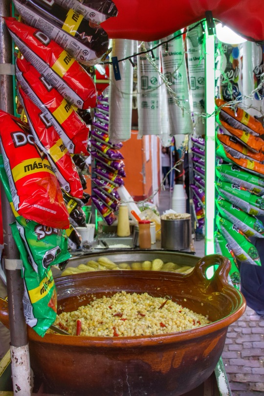
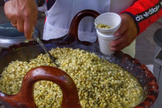
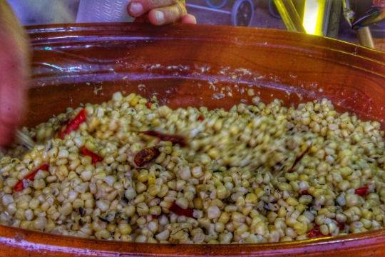


#food#foodporn#comida#mexicanismos#comida mexicana#mexican food#mineral del monte#real del monte#Hidalgo#México#elotes#elote#esquites#doriesquites#mexican street#mexican street food#mexican street corn#street food#comida callejera
16 notes
·
View notes
Text


#religion#catholic#catholiscism#catholocism#santos#saints#antique saints#Hidalgo#mineral del monte#pphr#scary art#scary#black & white#black and white photography
1 note
·
View note
Text
Brutalist Modern Home Built into Forest Hillside
There’s a forceful yet elegant modernism to the Oruc House, a home designed for Mineral del Monte, Mexico. Designed by Ukrainian team Anastasiia Sholopova and Yuriy Bobak, we see a tough exterior of concrete and glass, with a cantilevered main level jutting out of the hillside. A steel slab deck extends from the glass, with a covered concrete roofline that has custom cutouts for the tall fir…
0 notes
Text


Navidad, Mineral del Monte, Hidalgo
1 note
·
View note
Text


Oruç House, Mineral del Monte, Mexico - Saavedra Arquitectos
#Saavedra Arquitectos#architecture#design#building#modern architecture#interiors#minimal#house#house design#concrete#modern#modernist#brutalist#concrete house#masonry#tower#balcony#wood burning stoves#chimney#forest#trees#nature#dark#cosy#living room#bedroom#mexico#cool architecture#beautiful houses#mexican architecture
217 notes
·
View notes
Text
Os dejo este vídeo, que ya tiene un tiempo, de cuando recorría tierras galaicas.
También os dejo un texto donde explica el origen y el porqué de ese “túnel” en el río.
Los romanos llegaron a Galicia y se quedaron sobre todo por ser fuente de abundante materia prima mineral y natural. Para su localización, se recorría cada rincón de la región y para la extracción del mineral se recurría a cualquier método que facilitara su explotación. En tierras de Quiroga, el Sil discurre caprichosamente formando grandes meandros y grandes valles, para así salvar la dureza de estas rocas. En uno de ellos, justo 1 km antes de que las aguas del Bibei se mezclen con las del Sil, existe un meandro que su curva describe un bucle de casi 2,5 km.
Sin embargo, las aguas del río daban esta vuelta para poder salvar una dura pared rocosa, que separaba la otra esquina del meandro en tan solo en 140 metros. Los romanos sabían que el Sil arrastraba oro, y para ello decidieron secar el meandro. ¿Y cómo? Decidieron «furar» (horadar) el monte para poder desviar el río. Así, los 2,5 km del meandro se secarían y facilitaría enormemente la tarea de la búsqueda y extracción de tan preciado metal. Fue construido en el siglo II, en tiempos del emperador Trajano.
Su construcción original constaba de un túnel de 120 m de largo por 20 m de alto. Desafortunadamente, en el año 1934, una enorme riada tiró gran parte del túnel, dejándolo en sólo 52 m, que es lo que hoy se conserva. Se trató de una de las mayores obras de ingeniería romana de la Península, lo que nos lleva a pensar en su prolífica producción de oro. Se cuenta que miles de hombres buscaban el preciado mineral y llegaban a recoger hasta 20.000 libras de oro anuales que eran enviadas, en su mayoría, a Roma.
#los drones no rebotan#el niño de los drone#yuneeceurope#Yuneec España#monte furado#Quiroga#lugo#galiciaendrone#galicia
35 notes
·
View notes
Text
Translation/transcript:
Have you ever wondered what interest the UK has in occupying two islands that are 12 thousand kilometers away, over 191 years?
(Text over the image within the dark blue square: The forceful takeover of the Malvinas in 1833 wasn’t an isolated event: it answered to a policy that sought to ensure the influence of the United Kingdom on the American continent.)
The colonization of the Islas Malvinas (Falkland Islands) reveals some of the motives of the colonization that began in January 3, 1833:
Around 1 thousand kilometers away, down south, is Antarctica, territory over which the UK maintains sovereignty claims that overlap with Argentina’s and Chile’s.
(Antarctica has 70% of the world’s fresh water reserves, plus large quantities of minerals and hydrocarbons.)
To the East is the Atlantic Ocean, where the UK also has control over the Georgias Islands and Sandwich Island, Tristan da Cunha, Santa Elena and Ascensión—where the UK has an air base.
(Text within the dark blue square: the Atlantic is the most traveled ocean in the planet and brings 1.5 billion of dollars per year to the global economy.
The UK owns a chain of islands that surrounds South America: The Georgias Islands, Sandwich Island, Tristan da Cunha, Santa Elena and Ascensión.
The air base in the Ascensión Island is used together by the UK and USA.)
To the West, there’s the uninhabited Patagonia and the passages of Drake, Beagle and Magallanes, the only pathways that connect the Pacific with the Atlantic ocean beyond the Panamá canal.
(In the Pacific Ocean, the UK owns the Pitcairn Islands since 1838.)
Up North there’s South America with its invaluable riches, and the Caribbean islands that are part of the British crown, plus the tail end of the Cuenca del Plata—through which millions of tons of food are transported to the rest of the world.
(British colonies: British Virgin Islands, the Turcas and Caicos, the Bermudas, Caiman, Montserrat and Anguilla.
Members of the British commonwealth: Guyana, Barbados, Dominica, and Trinidad y Tobago.
Members of the British commonwealth that recognize UK’s monarchy as the supreme authority: Antigua y Barbuda, San Vicente and the Granadinas, Belice, Canada, Granada, Bahamas, Jamaica, Santa Lucia and San Cristóbal and Nieves.
Free sailing/travel through the Cuenca del Plata was always of interest to the UK, which culminated in the War of Parana in 1845-1850.)
Having control over the islands means having control over an enormous maritime surface, with control of maritime traffic and exploitation of fishing and hydrocarbon resources.
(The sovereignty of the Islas Malvinas also includes Islas Georgias and Sandwich del Sur, plus the maritime spaces around them, which in total constitute a surface of 2.600.000 km².
-The fishing industry in Islas Malvinas extracted 26 thousand millions of dollars in the last 40 years.
-It’s foreseen that in 2025 the oil exploitation will start in the islands.)
Maybe all of that explains why the Islas Malvinas are one of the most heavily militarized territories in the world, where the biggest military base of the southern hemisphere operates.
(The military, missile, naval and air base “Monte Agradable” is located 700km away from continental Antartida.
With around 1500 soldiers over a population of 3000 people total, the Islas Malvinas is one of the most militarized territories in the planet.)
Despite all the protests and arguments from Argentina, the UK maintains ownership of the islands for 191 years, violating the territorial integrity and Argentina’s maritime and bicontinental integrity.
Until our flag (Argentina’s) flies over the islands again, we must continue to denounce that the Islas Malvinas are and will be Argentina’s, always.
[ SOURCE ]
#argentina#islas malvinas#malvinas argentinas#colonization#colonialism#uk#the uk#history#politics#argentina politics#blob post
39 notes
·
View notes
Text
SET FIVE - ROUND ONE - MATCH ONE

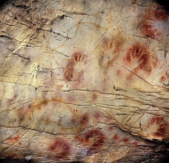
"Cueva de las Manos (Cave of Hands)" (created in several waves between 7,300 BCE and 700 CE) / "Cave of El Castillo" (c. 40,000 BP)
CUEVA DE LAS MANOS (CAVE OF HANDS): To me, it speaks to the vast continuity of humanity and human creativity. People were there and they left behind something of themselves. (cesiousblue) (also submitted by anonymous and jedi-ranger)
CAVE OF EL CASTILLO: these handprints are from el castillo cave in spain. over 40,000 years old. they were made by blowing hand-ground pigments through a hollow reed or bone onto hands placed against the cave wall. for a long time it was assumed that most cave paintings were made by adult men. a recent effort by a group of archaeologists to digitally scan and compile these (and others in nearby cave systems) have shown that about 25% of the handprints belong to children. the process of loading and blowing the pigments was a difficult one, that would have had to be done by an adult. which means that this wall, and others like it, were entirely communal. these were places where adult prehistoric humans took the time to teach their children art. over thirty thousand years before gilgamesh was committed to written language. humans were committing their children’s handprints to stone. the way they must have valued their families, their communities, their art, to go through the process of making this art with them. and not only that, but just the sheer relatability of the action itself! if you transported 40,000 years in the past you’d have little in common on a high level with the humans you’d find. you can’t really talk about your data entry job with the hunter gatherer. but you’d still get a kick out of blowing ground ochre pigment over your hand onto a cave wall. and they’d get a kick out of helping you do it. humans have always been humans. doesn’t it just make you want to fall to your knees at walmart, how beautiful it all is? (source for nerds who care, like me: https://news.artnet.com/art-world/children-worlds-first-artists-new-study-finds-quarter-prehistoric-spanish-hand-paintings-kids-13-2084734/amp-page) (isawken)
("Cueva de las Manos" (Cave of Hands) is located in Santa Cruz, Argentina and consists of outlines of hands, as well as some depictions of animals and hunting scenes created using various mineral pigments and gypsum on rock. The paintings cover about 60 m × 200 m (200 ft × 650 ft) of the cave.
"Cueva del Castillo" (Cave of the Castle) is located within the Caves of Monte Castillo in Puente Viesgo, Cantabria, Spain. The cave consists of over depictions of human hands, animals, and geometric shapes, including the oldest cave art in the world.)
#prehistoric cave art battle </3#art that fucks you up tournament#polls#atfyu polls#id in alt text#ugh before present. that's 38000 bce. probably#thaaat's archaeology for you!#yes i'm absolutely using current era instead of anno domini what of it
100 notes
·
View notes
Text

Another piece for Frankelda Day. Having a rap battle against a horse's skull to keep them form coming into your house and stealing your booze might be the most badass Christmas Tradition ever, tbh.
(Apparently, Mary Lwyd did make it to some parts of Cornwall and a lot of the 'Adventurers' that migrated to Mineral del Monte were Cornish, so I have some leeway to headcanon that Francisca got to participate to this tradition... unless her grandma scared people away with like holy water or something. Wouldn't put it past her.)
26 notes
·
View notes
Text
Oaxaca’s Culinary and Cultural Delights: Mexico’s Southern Gem

Nestled in the foothills of the Sierra Madre, Oaxaca (pronounced wah-HAH-kah) is a vibrant city in southern Mexico that enchants visitors with its rich traditions, colonial architecture, and tantalizing cuisine. Known as the gastronomic heart of Mexico, Oaxaca also serves as a hub of indigenous culture and artistry. Whether you’re a foodie, history enthusiast, or art lover, this city offers something special for everyone.
Exploring Oaxaca’s Culinary Heritage
Oaxaca is often referred to as the “Land of the Seven Moles,” a nod to its diverse and flavorful sauces that define Oaxacan cuisine.
Traditional Markets
Visit Mercado Benito Juárez and Mercado 20 de Noviembre to experience authentic flavors. Sample freshly made tlayudas, tamales wrapped in banana leaves, and chapulines (crispy grasshoppers).
Don’t miss tasting hot chocolate made with hand-ground cacao and cinnamon—a cherished Oaxacan tradition.
Mole Magic
Try mole negro, a rich sauce made with over 30 ingredients, including chocolate, chilies, and spices. Pair it with chicken or enchiladas for a classic dish.
Join a local cooking class to learn the secrets of crafting these complex flavors.
Mezcal Tastings
Oaxaca is the birthplace of mezcal, a smoky spirit made from agave. Visit mezcalerías to sample varieties and learn about the artisanal production process.
Cultural Treasures in Oaxaca
Oaxaca is a UNESCO World Heritage Site, thanks to its well-preserved colonial architecture and vibrant cultural traditions.
Zócalo and Santo Domingo Church
The city’s main square, or Zócalo, is a lively hub surrounded by cafes and street performers.
Visit the stunning Templo de Santo Domingo de Guzmán, a baroque masterpiece with an attached museum showcasing Oaxaca’s history.
Textiles and Crafts
Explore local workshops in nearby villages like Teotitlán del Valle, known for handwoven rugs dyed with natural colors.
Browse artisan markets for pottery, alebrijes (colorful carved animals), and embroidered garments.
Day Trips from Oaxaca
The region surrounding Oaxaca City is equally rich in history and natural beauty.
Monte Albán
Discover the ancient Zapotec ruins of Monte Albán, perched on a hilltop with panoramic views of the valley.
Marvel at the impressive pyramids, ball courts, and intricate carvings that reveal the sophistication of this ancient civilization.
Hierve el Agua
A natural wonder resembling petrified waterfalls, Hierve el Agua is perfect for hiking and swimming in mineral-rich pools.
Mitla and Mezcal Villages
Explore the Mitla archaeological site, an ancient Mixtec ceremonial center known for its intricate geometric stonework.
Tour nearby mezcal-producing villages for a deeper dive into this iconic Oaxacan spirit.
Oaxaca’s Festivals and Traditions
Guelaguetza Festival
Held in July, this indigenous cultural festival showcases traditional dances, music, and costumes from Oaxaca’s diverse regions.
Day of the Dead (Día de los Muertos)
Experience the city’s vibrant celebrations in late October and early November, featuring ornate altars, marigold decorations, and lively parades.
Practical Travel Tips
When to Visit
October to April offers pleasant weather and coincides with major festivals.
What to Pack
Comfortable walking shoes, lightweight clothing, and a reusable water bottle.
Getting Around
The city is walkable, but taxis and colectivos (shared vans) are convenient for trips to surrounding areas.
Travel Assistance
To make the most of your Oaxacan adventure, consider consulting experienced travel agencies like Roomchai Limited, which can help plan personalized itineraries, including guided market tours, mezcal tastings, and visits to archaeological sites.
Conclusion
Oaxaca’s charm lies in its perfect blend of tradition and modernity. From its flavorful cuisine to its stunning ruins and vibrant festivals, this southern gem offers an unforgettable experience that will leave you yearning for more. So, pack your bags and let Oaxaca’s culinary and cultural delights captivate your senses.
#Oaxaca#mexico#roomchai#roomchailimited#travel#dhakatravel#traveltips#bangladeshitravelers#travelagencies
3 notes
·
View notes
Text
EL HOMBRE DE LA BANCA
Hay un hombre sentado en una banca en una plaza en un pueblo. La banca es de cemento, donada por alguna de las familias del pueblo y el nombre de la familia queda estampado en el respaldo.
El pueblo es como cualquier otro pueblito del altiplano. Tiene poca gente, el ambiente es seco y frío, hay aromas de humo, hojas secas, estiércol y mineral, los perros ladran y hay más viejos que jovenes.
EL hombre que está sentado en la banca es uno de esos viejos. Todos lo conocen y él conoce a todos. Todos los días llega a la plaza y se sienta en la misma banca y contempla el atardecer. Lo reciben un montón de ruidosos zanates y tordos y se reúnen a su alrededor. Luego de un rato, ya cuando ha bajado el sol y se acerca la oscurana, se levanta y se marcha. Las aves remontan el vuelo y se posan sobre las ramas secas de los árboles de la plaza. Comienza a soplar un viento frío y cae la noche. Suenan las campanas de la iglesia a la cual nadie asiste ya, se encinenden luces en todas partes y los grillos comienzan su canto.
La banca donde este hombre siempre se sienta lleva el nombre de su familia, por ello es su preferida. És el último que queda de la familia.
Todas las tardes gente atraviesa la plaza, lo ven, lo saludan y él regresa el saludo. Nadie conversa, sólo se miran y asienten. Por ahí pasa el que atiende la miscelánea, luego la señorita de la panadería, el de la ferretería, la señora de la esquina, el que cuida burros y caballos, el tipo que anda siempre con tres perros, el que repara y pinta, la doña que cocina y un señor que no hace nada más que recorrer todo el pueblo a pie.
Esa tarde el señor que se sienta en la banca de su familia no llegó. La gente que pasa por ahí todos los días no lo advirtió. Pero al día siguiente comenzaron a darse cuenta.
Al tercer día se preguntan entre ellos si alguien había visto al señor de la banca. Todos dijeron que no.
Al cuarto día se corrió la voz, la gente comenzó a preocuparse y empezaron las suposiciones; se habrá enfermado, se fue de viaje, se ocupó en algo, vinieron por él, se murió.
Al quinto día se reunieron en la plaza, justo frente a la banca del señor, y hablaron de varios asuntos. ¿Tiene familia? No. Él era el último. Vamos a su casa. Ya llegan. Llaman a la puerta. No hay respuesta. Gritan su nombre. Nada. alguien se brincó la reja, le dio la vuelta a la casa y entró por la puerta de atrás. Atravesó la casa y abrió la puerta principal para que los otros entraran. Las cosas están en su lugar. Hay fotos, adornos y vasijas de porcelana polvorientas. La atmósfera está como difuminada. En la mesita de la cocina se ven una taza fracturada con un poco de café frío y un plato de peltre con migajas. En la pequeña despensa hay latas, especias, una bolsa de arroz y otra de frijoles. La sala parece que no la han usado en muchos años. Entran a la recámara. Aquí no hay nadie. La cama está tendida, la ropa colgada, los zapatos en su lugar. Vamos al baño. Las toallas secas, dobladas sobre el tubo transversal. Botiquín con medicinas caducas y un olor a mentol, alcanfor y alcohol. Recorren la cortina de la regadera: está seca y polvosa. La casa, pues, está vacía.
Al sexto día se organizaron y lo buscaron por todo el pueblo y como el pueblo es pequeño no tardaron en recorrerlo todo. Pero no lo encontraron. Al final del día se reunieron en la plaza y concluyeron que el hombre de la banca se había marchado. Pero desaparecer de esa manera, sin dar aviso, sin despedida, qué inconsistencia.
Séptimo día. La gente ha vuelto a su habitualidad, a sus recorridos y rutinas. Ya atienden sus negocios, preparan la comida, reparan cosas, escuchan la radio o hacen mandados y diligencias. Atraviesan la plaza, como todos los días. Al principio no lo notan, pero alguien se da cuenta: se detiene frente a la banca donde se sentaba el señor a contemplar el atardecer y advierte que el estampado con el nombre de su familia ha desaparecido. Sólo queda una fría y grisácea banca de cemento.
De pronto, un montón de zanates y tordos posan sobre ella.En silencio.

2 notes
·
View notes
Text


Yu-Gi-Oh Go Rush 64
Phaser en su forma dragón y Yudias intenta continuar el duelo para intentar parar con esto
Trémolo explica que la familia Ryugu fluye la sangre de dragón espacial
Phaser decide recupera la conciencia decide continuar con el duelo ante Yudias
Debido a este odio a los extraterrestres se creó MIK y agregando que la familia Ryugu ha vivido en desde mucho antes que se construyera ciudad Motsuba ocultando el secreto de los extraterrestres a la vista
Cierre de poder a poder entre Yudias y Phaser, después del choque de sus Maximum lo resolvieron sus as distintos pero la estrategia de Yudias supera totalmente la de Phaser
De vuelta a la normalidad
Un mineral misterioso que atrae a los extraterrestres.
Su verdadera identidad es el fósil de un dragón cósmico, que ha estado durmiendo durante mucho tiempo en el monte Mutsuba. ¡Y esa fue la razón por la que tantos extraterrestres vinieron a Mutsuba!
3 notes
·
View notes
Text
El 6º Tribunal Internacional de los Derechos de la Naturaleza se reunió el 28 de febrero de 2025 en la Universidad de Toronto (Canadá) para analizar los devastadores efectos de las industrias extractivas canadienses, en particular sobre los pueblos indígenas y sus comunidades, los sistemas hídricos y los ecosistemas críticos de todo el mundo. Con casos que abarcaban Brasil, Argentina, Chile, Ecuador, Serbia y el propio Canadá, el Tribunal, cuyo tema era “Los impactos de la minería y la era posterior al extractivismo”, escuchó desgarradores testimonios de defensores de primera línea, expertos jurídicos y activistas medioambientales que expusieron el papel de Canadá en la perpetuación de la destrucción del medio ambiente y las violaciones de los derechos humanos a través de sus políticas mineras y comerciales, justo a tiempo para la Conferencia de la Asociación de Prospectores y Desarrolladores de Canadá (PDAC, por sus siglas en inglés), una reunión emblemática de la industria minera mundial, que tendría lugar la semana siguiente en Toronto. “La industria afirma que está construyendo el futuro, pero el único futuro que garantiza es el de la sequía, la contaminación y el desplazamiento”, declaró James Yap, Fiscal de la Tierra. “Hoy rechazamos el mito de que la extracción a toda costa es inevitable. Pedimos el fin de la era del saqueo y el comienzo de una era de restauración, regeneración y respeto.” Un patrón global de destrucción Las pruebas presentadas al Tribunal dejaron claro que las actividades mineras plantean graves riesgos para las personas y el planeta: Ana Zbona, experta del Business & Human Rights Resource Center, explicó los efectos devastadores de la minería de minerales de transición en el contexto de la actual crisis climática, a través de las conclusiones del Transitions Minerals Tracker, que ha registrado más de 600 denuncias de abusos contra los derechos humanos relacionados con operaciones mineras a gran escala. Destacó el impacto desproporcionado de estas actividades en las comunidades indígenas, ya que más del 50% de los minerales de transición se encuentran cerca o en tierras indígenas. Además, subrayó los peligros a los que se enfrentan los defensores de los derechos humanos, siendo la minería el sector más peligroso para los activistas, ya que a menudo se producen amenazas, intimidaciones e incluso asesinatos. En sus recomendaciones, Zbona pidió la diligencia debida obligatoria en materia de derechos humanos, negociaciones justas con las comunidades y tolerancia cero con los ataques a los defensores, e instó a gobiernos y empresas a dar prioridad a las prácticas mineras responsables: “No tenemos que elegir entre luchar contra el cambio climático y proteger los derechos humanos. Una transición justa debe significar trabajar por una mayor equidad e igualdad globales, lo que significa que primero deben considerarse las opciones políticas para reducir la demanda de nuevos minerales.” Brasil | Minería en la Amazonia: un desastre en ciernes Ana Laide Soares Barbosa, miembro del movimiento Xingu Vivo, y Verena Glas, de la Fundación Rosa Luxemburgo, denunciaron a la empresa minera canadiense Belo Sun por sus operaciones en la Volta Grande do Xingu, una región ya devastada por la presa hidroeléctrica de Belo Monte. “Belo Sun llegó sin permiso, sin consulta y con violencia”, afirmaron. El proyecto, advirtieron, podría desencadenar uno de los peores desastres medioambientales de Brasil, ya que las explosiones cerca de la presa de Belo Monte amenazan su integridad estructural. Además, se prevé que la mina extraiga 43.000 metros cúbicos de agua por hora, agravando la crisis hídrica de la región. “Más de 50 personas han sido judicializadas por defender sus tierras, y un defensor de los derechos humanos ya ha sido asesinado”, declararon. El Tribunal tuvo conocimiento de la detención de José Rones, agricultor del asentamiento de reforma agraria PA Ressaca, en Pará (Brasil), en medio de conflictos con la empresa ...

View On WordPress
0 notes
Text
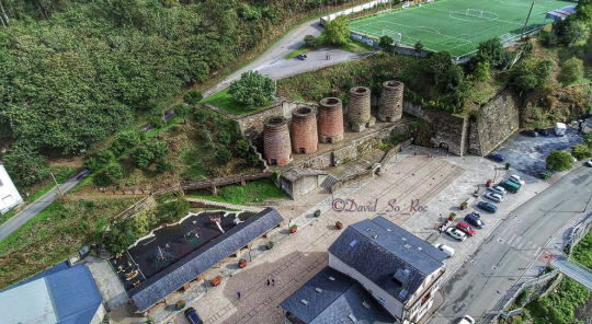
Hoy he estado currando cerca de Galicia y no me podía marchar sin visitar a unos buenos amigos en A Pontenova. Os dejo una foto de estos antiguos hornos de mineral, los cuales son un pequeño reclamo turístico de la zona y también os dejo una pequeña explicación de su historia.
Lo que queda de los hornos es el vestigio del pasado industrial y del potencial minero de A Pontenova. Se dedicaban al procesado del mineral de hierro. La época de mayor esplendor llegó en 1900 con la creación de la “Sociedad Minera de Vilaoudriz” por Julio Lazúrtegui. Sus cinco chimeneas son troncocónicas con una altura de 11 metros y anchura de 4 metros.
En ellos se mezclaba la limonita con capas intermedias de carbón sometiéndolos a un proceso de calcinación a fin de separar los residuos fosfóricos, los cuales se empleaban posteriormente como abonos
En los montes de Vilaoudriz se explotaron varias minas de hierro fosfórico, se llamaron “Luisa”, Vieiro” y el grupo “Consolo-Boulloso”.
El cese total de las actividades mineras e industriales tuvo lugar en 1964.
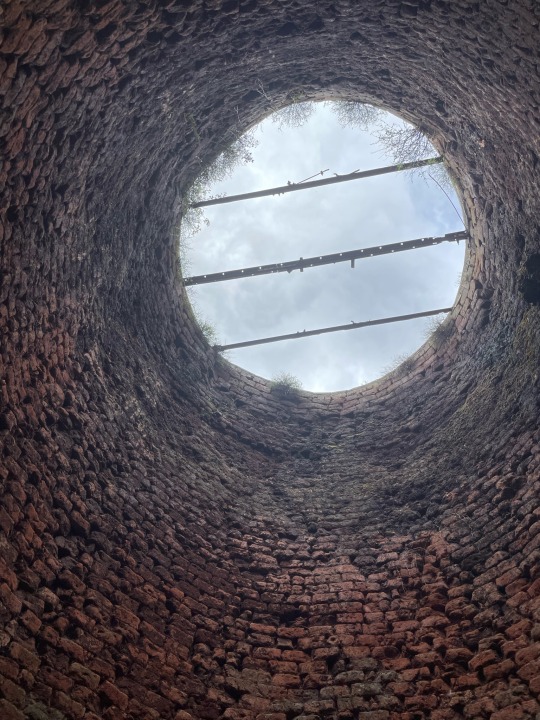
Como curiosidad, a día de hoy se puede visitar parte de las antiguas minas que surtían de mineral estos hornos. En concreto la Mina Consuelo, donde se puede recorrer parte de sus galerías e incluso descender en tirolina como antiguamente.
5 notes
·
View notes


