#Klamath Basin
Explore tagged Tumblr posts
Video
Saturday Sunrise at the Stateline (3 of 3) by Greg Brown Via Flickr: Back in the DINK (Double Income, no Kids) days, we usually went to Klamath Falls for Memorial Day weekend. In 1996, we maintained the tradition. On the way home from work Friday afternoon, we saw Southern Pacific makinq up the Los Angeles bound Swift RoadRailer at Brooklyn Yard in Southeast Portland. The Portland-LA RoadRailer had just entered revenue service a couple of months earlier. I got up before sunrise in Klamath on Saturday morning, hoping to intercept the RoadRailer somewhere. At the time, I didn't know that you could use SP's car tracing 800 number to find the location of the RoadRailer trailers. My plan was to go to the Oregon/California stateline, listen to the scanner, and see what developed. As I left Klamath Falls, I saw a northbound BNSF train entering the SP at Bieber Line Junction. Burlington Northern had been merged with Santa Fe the previous September, but the new BNSF had made no blatant operational changes at Klamath Falls. Trains still ran with cabooses, in deference to the hand throw turnouts on Oregon Trunk sidings. Chatter between BN/BNSF crews was often a good source of information. It would prove to be so today. Not long after I arrived at the stateline, a westbound SP drag came into view. It had four units running elephant style, including a Conrail GE and a Rio Grande tunnel motor. As the train passed, I thought about taking off south and chasing it - until the scanner gave me the traffic report I was waiting for. The SP dispatcher had advised the BNSF train that he would hold at the east end of Klamath Falls Yard for one train before he could enter the main and head for Bend. When that train arrived at Klamath, here's what I heard on the BNSF road channel: BNSF Engineer: Wait 'til you see the train they stuck us for. You won't believe it!" BNSF Conductor: "How so?" BNSF Engineer: "This poor SP is gettin' so hard up, they can't even afford flatcars for their pig trains!" About 25 minutes later, the RoadRailer rolled through Worden, climbed the big fill on the mid-60s line change at the Lake Miller dry lake bed, and passed me. It was the start of a great chase that ended late that morning in the Sacramento River Canyon. In this image, the westbound RoadRailer is approaching the Oregon/California state line. A dozen years earlier, when SP 4449 was enroute to New Orleans, there were at least 100 photographers here.
#Worden#Oregon#Southern Pacific#SP#SP Oregon Division#SP Black Butte Subdivision#Klamath County#Klamath Basin#EMD#Freight Train#Railroads#Railroad#Railway#Trains#Train#Swift RoadRailer#RoadRailer#Intermodal#flickr
4 notes
·
View notes
Text

2 notes
·
View notes
Text
Excerpt from this story from Oregon Public Broadcasting:
At a small dam on Sun Creek made out of corrugated vinyl sheeting, National Park Service fish biologist Dave Hering shuts off water leading into a metal box the size of a small elevator.
Michael Scheu, one of Hering’s team members, climbs inside. Surrounding his feet are twelve bull trout. They got trapped here trying to head upstream. Scheu collects half of them in a black bucket, handing it off to another team member above.
Bull trout are the only remaining native fish species in Crater Lake National Park. They used to be found all over the Klamath Basin, Hering says, including nearby Fort Creek.
“Fort Creek is a place where a bull trout was sampled in the 19th century and actually held in the Smithsonian,” says Hering. “And for decades, including the whole first 15 years of my career here, we didn’t have bull trout there anymore.”
Competition from a closely related cousin, the brook trout, introduced for fishing in the early 1900s, was the primary factor leading to bull trout being listed as threatened under the Endangered Species Act in 1998.
Native to the eastern U.S., brook trout evolved with slightly different traits that allow them to outcompete the bull trout in its natural habitat. They mature at a younger age, thereby producing more eggs over a longer period of time than bull trout, among other advantages.
In 1989, scientists found a disturbingly small number of bull trout high up Sun Creek, inside the national park. Mark Buktenica is the now-retired fish biologist for the park service who began the effort to save the species.
“The National Park Service mandate from Congress is pretty clear,” Buktenica said on a 1999 episode of Oregon Field Guide. “We’re supposed to preserve and protect these ecosystems in their natural condition. Well, the natural condition for Sun Creek is to have resident bull trout.”
Back then, Buktenica and his team built two dams on Sun Creek to prevent non-native fish from getting further upstream. Then, they used a specialized poison to kill any brook trout upstream of the dams.
Hering took over Buktenica’s work when he retired in 2017. He says he’s gotten more and more invested since their population has grown in number.
“A lot of people — anglers and fish enthusiasts — describe it as sort of an ugly fish or one that isn’t as nice to look at as some others. But I think they’re beautiful,” Hering says.
Hering was there when, in 2017, scientists reconnected Sun Creek to the Wood River for the first time in over 150 years. The tributary had been isolated on private land and used for irrigation, cutting bull trout off from other parts of the Klamath Basin.
16 notes
·
View notes
Text
Official nature post
Hey, don't cry. First salmon spotted returning to sites on the Klamath River previously dammed for more than a century, okay?
https://www.sfchronicle.com/california/article/klamath-dam-removal-salmon-19844792.php
14K notes
·
View notes
Text
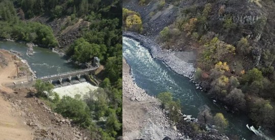
"For years, California was slated to undertake the world’s largest dam removal project in order to free the Klamath River to flow as it had done for thousands of years.
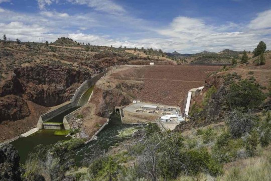
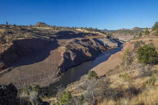
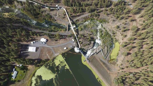
Now, as the project nears completion, imagery is percolating out of Klamath showing the waterway’s dramatic transformation, and they are breathtaking to behold.

Pictured: Klamath River flows freely, after Copco-2 dam was removed in California.
Incredibly, the project has been nearly completed on schedule and under budget, and recently concluded with the removal of two dams, Iron Gate and Copco 1. Small “cofferdams” which helped divert water for the main dams’ construction, still need to be removed.
The river, along which salmon and trout had migrated and bred for centuries, can flow freely between Lake Ewauna in Klamath Falls, Oregon, to the Pacific Ocean for the first time since the dams were constructed between 1903 and 1962.
“This is a monumental achievement—not just for the Klamath River but for our entire state, nation, and planet,” Governor Gavin Newsom said in a statement. “By taking down these outdated dams, we are giving salmon and other species a chance to thrive once again, while also restoring an essential lifeline for tribal communities who have long depended on the health of the river.”
“We had a really incredible moment to share with tribes as we watched the final cofferdams be broken,” Ren Brownell, Klamath River Renewal Corp. public information officer, told SFGATE. “So we’ve officially returned the river to its historic channel at all the dam sites. But the work continues.”


Pictured: Iron Gate Dam, before and after.
“The dams that have divided the basin are now gone and the river is free,” Frankie Myers, vice chairman of the Yurok Tribe, said in a tribal news release from late August. “Our sacred duty to our children, our ancestors, and for ourselves, is to take care of the river, and today’s events represent a fulfillment of that obligation.”
The Yurok Tribe has lived along the Klamath River forever, and it was they who led the decades-long campaign to dismantle the dams.
At first the water was turbid, brown, murky, and filled with dead algae—discharges from riverside sediment deposits and reservoir drainage. However, Brownell said the water quality will improve over a short time span as the river normalizes.
“I think in September, we may have some Chinook salmon and steelhead moseying upstream and checking things out for the first time in over 60 years,” said Bob Pagliuco, a marine habitat resource specialist at the National Oceanic and Atmospheric Administration in July.


Pictured: JC Boyle Dam, before and after.
“Based on what I’ve seen and what I know these fish can do, I think they will start occupying these habitats immediately. There won’t be any great numbers at first, but within several generations—10 to 15 years—new populations will be established.”
Ironically, a news release from the NOAA states that the simplification of the Klamath River by way of the dams actually made it harder for salmon and steelhead to survive and adapt to climate change.
“When you simplify the habitat as we did with the dams, salmon can’t express the full range of their life-history diversity,” said NOAA Research Fisheries Biologist Tommy Williams.
“The Klamath watershed is very prone to disturbance. The environment throughout the historical range of Pacific salmon and steelhead is very dynamic. We have fires, floods, earthquakes, you name it. These fish not only deal with it well, it’s required for their survival by allowing the expression of the full range of their diversity. It challenges them. Through this, they develop this capacity to deal with environmental changes.”
-via Good News Network, October 9, 2024
#california#oregon#klamath river#dam#dam removal#yurok#first nations#indigenous activism#rivers#wildlife#biodiversity#salmon#rewilding#nature photography#ecosystems#good news#hope
6K notes
·
View notes
Text
Only four months after dams blocking migration were removed, the first Chinook salmon traveled 230 miles to return to the Klamath River Basin. This was the first fish to come home to their ancestral migration routes since 1912.
Over 100 years shut out and it only took them four months to return home once they had the chance.
From the article:
“The return of our relatives the c’iyaal’s is overwhelming for our tribe. This is what our members worked for and believed in for so many decades,” said Roberta Frost, Klamath Tribes Secretary. “I want to honor that work and thank them for their persistence in the face of what felt like an unmovable obstacle. The salmon are just like our tribal people, and they know where home is and returned as soon as they were able[.]"

#hope#good news#dam removal#salmon conservation#river conservation#indigenous conservation#endangered species#environment#biodiversity#hopepunk#chinook salmon#salmon migration#habitat restoration
2K notes
·
View notes
Text
First Salmon Since 1912 Spotted in Klamath Basin Just Weeks After Dam Removal in Oregon https://www.goodnewsnetwork.org/first-salmon-since-1912-spotted-in-klamath-basin-just-weeks-after-dam-removal-in-oregon/
#good news#environmentalism#science#environment#nature#animals#conservation#salmon#klamath river#oregon#usa
211 notes
·
View notes
Text
Can you imagine how many have been trying all this time?

🏞️ !!! happy breaking news !!! after more than 100 years, fall-run Chinook salmon have returned to the Klamath River Basin: one month after the last dam obstacle was removed!!! 🏞️ Mark Hereford, ODFW’s Klamath Fisheries Reintroduction Project Leader, was part of the survey team that identified the fall-run Chinook. His team was ecstatic when they saw the first salmon.
“We saw a large fish the day before rise to surface in the Klamath River, but we only saw a dorsal fin,” said Hereford. “I thought, was that a salmon or maybe it was a very large rainbow trout?” Once the team returned on Oct. 16 and 17, they were able to confirm that salmon were in the tributary.
It marks the return of migrating fish to the area following the removal of four Klamath River dams. The salmon likely traveled 230 miles from the Pacific Ocean.
49 notes
·
View notes
Text

In early October, the first time in 100 years, salmon were observed swimming past the sites of former dams as they migrated from the ocean into the Klamath River. This was made possible by the removal of dams that previously blocked salmon from completing their historic migration.
Interested in learning more? Join the California History Section for their next Speaker Series virtual talk, Toward a Decolonial Future: Klamath River Temporary Dams with Dr. Brittani Orona on Wednesday, November 13 at 4PM. With the four dams removed, this talk will explore the relationship of the lower Klamath River and how Hupa, Yurok, and Karuk story and ceremony intertwine on the Basin to build a new, decolonial future for the river itself.
The event is free but requires registration. For more information and to register, visit https://libraryca.libcal.com/calendar/californiastatelibrary/KlamathRiver .
42 notes
·
View notes
Text
Welcome home, cousins. We missed you!
31 notes
·
View notes
Text


West Diamond Lake Highway, OR (No. 3)
Odell Lake is located near Willamette Pass in the northwest corner of Klamath County, Oregon, United States. It is one of several lakes in the Cascade Range in Central Oregon, and lies within the Deschutes National Forest. It was named for Oregon Surveyor General William Holman Odell by Bynon J. Pengra, in July 1865, while they were making a preliminary survey for the Oregon Central Military Road, which would later become Oregon Route 58. The lake fills a basin carved by a glacier, and the resulting terminal moraine confines the water along the lake's southeast shore.
Source: Wikipedia
#Diamond Peak Lookout Point#Odell Lake#Diamond Peak#Boundary Springs Trailhead#West Diamond Lake Highway#Mount Thielsen#High Cascades#Mount Bailey#travel#original photography#vacation#tourist attraction#landmark#landscape#countryside#USA#California#summer 2023#flora#nature#forest#woods#tree#view#Westcoast#Cascade Range#Oregon#Pacific Northwest
14 notes
·
View notes
Text


introducing Yadonite
"Yadenite is a term used by rockhounders in Klamath Falls in reference to a type of opalite found on hillsides on the north side of town. The local occurrence of opalite was so named in honor of John C. Yaden, who helped organize the Klamath Mineral Society in Klamath Falls."
Yadonite (sometimes spelled Yadenite) is an opaline chert rock described as having “a vitreous and pearly luster, and... Color variations range from iron oxide red to pure white.” - it is theorized to be "a type of silicified tuff with an exclusive undocumented chemical composition” and believed to be "made up of 20-plus minerals, including barite, celestite, bismutite, amorphous quartz, and potassium feldspar which form only in hydrothermal environments." - so far Yadonite has been "found exclusively in the Klamath Basin in the Yonna Formation of the Middle Pliocene Epoch".
[X] [X] [X]
While not much is definitively known about this unassuming rock it holds a very special place in my heart because it is actually named after my great-great grandfather <3 I grew up very close with my great-grandma (John C. Yadon's daughter) and she told me about her parents all the time and the love for nature, literature, and education they instilled in her which she passed on to me. I'm proud to say that today I have in my own rock collection pieces that John C. Yadon collected himself in the late 19th century. As far as I know all our pieces of Yadonite were passed on to extended family and donated to geological societies.
PS I'm not a geologist just an enthusiast so if I messed up some info please be kind <3
#geology#rockhound#yadonite#yadenite#klamath falls#oregon#california#enjoy my little educational post <3#rocks#natural history
15 notes
·
View notes
Text

3 notes
·
View notes
Text
Excerpt from this press release from the US Fish & Wildlife Service:
The U.S. Department of the Interior and U.S. Fish and Wildlife Service today announced nearly $46 million in investments from President Biden’s Bipartisan Infrastructure Law for ecosystem restoration activities that address high-priority Klamath Basin water-related challenges in southern Oregon and northern California.
In February, the Department announced a landmark agreement between the Klamath Tribes, Yurok Tribe, Karuk Tribe and Klamath Water Users Association to advance collaborative efforts to restore the Klamath Basin ecosystem and improve water supply reliability for Klamath Project agriculture. Funds announced today will support 24 restoration projects developed by signers of this agreement, as well as other Tribes and other conservation partners.
Through President Biden’s Investing in America agenda, the Department is implementing more than $2 billion in investments to restore the nation’s lands and waters. To guide these historic investments, and in support of the President’s America the Beautiful initiative,the Department unveiled the Restoration and Resilience Framework, to support coordination across agency programs and drive transformational outcomes, including a commitment to advance collaborative efforts to restore the Klamath Basin ecosystem and improve water supply reliability for Klamath Project agriculture through the Klamath Keystone Initiative. By working collaboratively with ranchers, state and local governments, Tribal nations, and other stakeholders, the Department is working to build ecological resilience in core habitats and make landscape-scale restoration investments across this important ecosystem.
Through the Bipartisan Infrastructure Law , the Service is investing a total of $162 million over five years to restore the Klamath region’s ecosystem and repair local economies. These investments will secure reliable water for the national wildlife refuges, advance the restoration of salmon post dam removal, address water quality and conveyance issues, and support co-developed restoration projects with Tribes, farmers and ranchers, and conservation partners.
As part of today’s investments, $13 million will be used to complete restoration of the Agency-Barnes wetland units of Upper Klamath National Wildlife Refuge and provide fish habitat access in Fourmile and Sevenmile creeks. Covering 14,356 acres, the restored wetland will create vital habitat for waterfowl, federally endangered Lost River and shortnose suckers, and other species, making it one of the largest wetland restoration initiatives in the United States.
4 notes
·
View notes
Photo

Report generated at 2024-11-20 15:09:32.942752-08:00 using satellite imagery and alert data provided by the National Weather Service.
Wind Advisory
Northeast Foothills/Sacramento Valley
Northern Lake County
Sonoma Coastal Range
Central Sacramento Valley
North Bay Interior Valleys
North Bay Interior Mountains
Mineral and Southern Lyon Counties
Mendocino Coast
Greater Reno-Carson City-Minden Area
Marin Coastal Range
Foothills of the Northern Blue Mountains of Oregon
Northern Sacramento Valley
Southern Lake County
Coastal North Bay Including Point Reyes National Seashore
San Francisco Bay Shoreline
Mono
San Francisco Peninsula Coast
San Francisco
Flood Watch
WA: Mason
Northern Lake County
Northwestern Mendocino Interior
Central Sacramento Valley
North Bay Interior Valleys
Del Norte Interior
Mountains Southwestern Shasta County to Western Colusa County
Shasta Lake Area / Northern Shasta County
Southern Trinity
Coastal Del Norte
Northeast Foothills/Sacramento Valley
Southwestern Mendocino Interior
Northern Humboldt Interior
North Bay Interior Mountains
Southwestern Humboldt
Sonoma Coastal Range
Southeastern Mendocino Interior
South Central Oregon Coast
Southern Lake County
Coastal North Bay Including Point Reyes National Seashore
Northern Humboldt Coast
Southern Humboldt Interior
Northeastern Mendocino Interior
Mendocino Coast
Marin Coastal Range
Northern Sacramento Valley
Winter Storm Warning
Sun Valley Region
Burney Basin / Eastern Shasta County
Western Siskiyou County
Western Plumas County/Lassen Park
North Central and Southeast Siskiyou County
West Slope Northern Sierra Nevada
Mountains Southwestern Shasta County to Western Colusa County
Sawtooth/Stanley Basin
South Central Siskiyou County
Shasta Lake Area / Northern Shasta County
Big Lost Highlands/Copper Basin
Okanogan Highlands
Northern Trinity
Northern and Eastern Klamath County and Western Lake County
Central Siskiyou County
South Central Oregon Cascades
Siskiyou Mountains and Southern Oregon Cascades
Winter Weather Advisory
North Oregon Cascades
Northern and Eastern Klamath County and Western Lake County
Central Panhandle Mountains
Northern Panhandle
Cascades of Lane County
Klamath Basin
East Slopes of the Oregon Cascades
West Central Mountains
Boise Mountains
Cascades of Marion and Linn Counties
West Slopes North Cascades and Passes
Northeast Mountains
Modoc County
Lassen-Eastern Plumas-Eastern Sierra Counties
High Wind Watch
Coastal Del Norte
Southern Humboldt Interior
Northern Humboldt Interior
Del Norte Interior
South Central Oregon Coast
Curry County Coast
Northern Humboldt Coast
Southwestern Humboldt
Flood Advisory
CA: Sierra, Lassen, Sonoma, Napa, Plumas
High Wind Warning
Central and Eastern Lake County
Northeast Siskiyou and Northwest Modoc Counties
Klamath Basin
Northern and Eastern Klamath County and Western Lake County
Central Siskiyou County
Modoc County
High Surf Advisory
Tillamook County Coast
San Luis Obispo County Beaches
Central Coast of Oregon
South Washington Coast
Santa Barbara County Central Coast Beaches
Central Coast
Clatsop County Coast
Coastal North Bay Including Point Reyes National Seashore
San Francisco Peninsula Coast
North Coast
San Francisco
Southern Monterey Bay and Big Sur Coast
Beach Hazards Statement
Northern Monterey Bay
Flood Warning
CA: Siskiyou
OR: Curry, Coos, Josephine, Jackson
Coastal Flood Advisory
Western Whatcom County
San Juan County
Lake Wind Advisory
Greater Lake Tahoe Area
Red Flag Warning
Lahontan Basin - Churchill and Eastern Mineral Counties
Southern Mono County
Southern Sierra Front - Alpine/Northern Mono/Southern Lyon/Western Mineral Counties
West Humboldt Basin - Pershing County
Northern Sierra Front - Carson City/Douglas/Storey/Southern Washoe/Eastern Lyon/Far Southern Lassen Counties
High Surf Warning
South Central Oregon Coast
Curry County Coast
Avalanche Warning
South Central Siskiyou County
5 notes
·
View notes
Text

Snow Globe
Klamath Basin, Oregon
Ice flakes fall gently from the trees catching winter light on a frigid morning. Ducks take off from the water below. Mixed shutter speeds and focal points. Something of a conceptual image here, something I will revisit more in the future. Photo © copyright by Marc Adamus.
4 notes
·
View notes
