#IcelandMap
Text
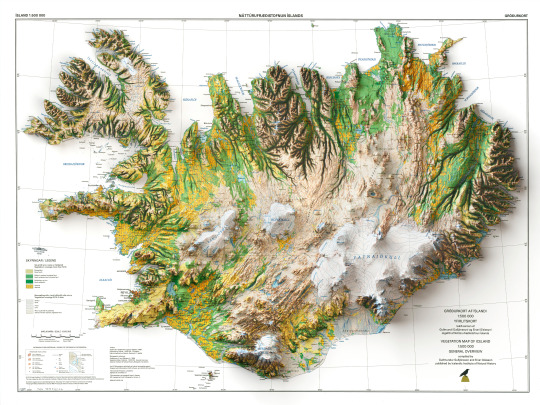
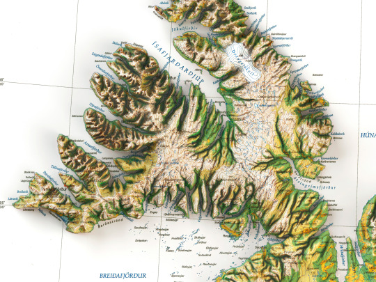
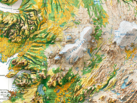
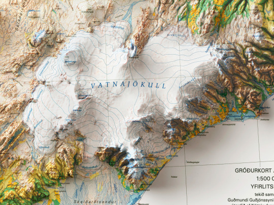
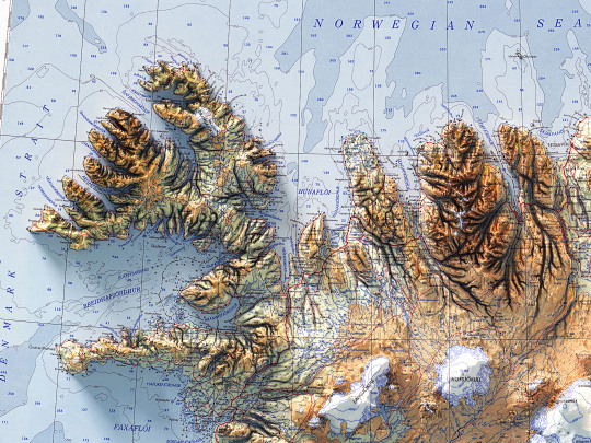
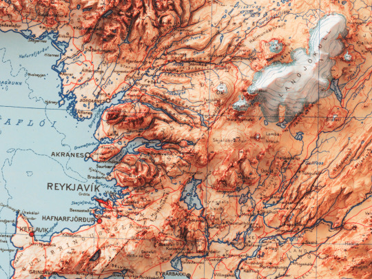
Here we are with the 2D printed shaded relief map with 3D effect of a soil map of Iceland, printed and published by Náttúrufræðistofnun Ísland in 1998.
🗺️ 𝗠𝗔𝗣 𝗜𝗡𝗙𝗢
Vegetation map of Iceland 1: 500 000, overview map / compiled by Guðmundur Guðjónsson and Einar Gíslason; 1998.
If you like our work, want to see our daily updates (or want to say hello to our studio), consider to follow our Instagram or Twitter account. Otherwise if are interested in our prints or have a custom request check our shop.
#dataviz#3dart#cartographyart#geographyart#mapart#artprint#reliefmap#homedecor#posterart#iceland#icelandmap#geography#artofinstagram#walldecor#maps#icelandart#icelandtravel#icelandlove
6 notes
·
View notes
Photo

Reykjanes Peninsula in Iceland: Things to Do, Itinerary, Map & Practical Tips
Calling all explorers. Brace yourself for an unforgettable journey through the incredible Reykjanes Peninsula in Iceland. From awe-inspiring geothermal areas to picturesque coastal hikes, get ready to experience the best this stunning region has to offer.
0 notes
Text
Reykjanes Peninsula in Iceland: Things to Do, Itinerary, Map & Practical Tips

Discover the enchanting wonders of the Reykjanes Peninsula in Iceland. Get ready for a playful adventure filled with breathtaking landscapes, hidden gems, and practical tips to make the most of your trip.
0 notes
Text


Yesterday helped hang the new show for our first Open Studio since pandemic. My contribution to the show is an installation (in progress).
I submitted a photo thinking it was just for promotional purposes, turned out that’s the work they selected for the show. Hilarity ensued. Luckily the IcelandMap installation is pretty light-weight and not difficult to redo in smaller scale. Especially since now I have the how.
The only annoying part is that while it’s totally awesome in person it’s absolutely impossible to photograph! Will try again when it’s finished.
0 notes
Photo

- Click Photo for Details - ★ Website ➔ www.InkistPrints.com ★ Etsy Store ➔ www.InkistPrints.etsy.com
#IcelandPoster#WallArt#StreetMap#IcelandMap#HomeGoods#MapPrint#BabyRoomDecor#ChristmasGift#Europe#IcelandPrint#AnniversaryGifts#MapPoster#BedroomWallArt#artwork#poster#decor#wallart#christmasgifts#valentinesdaygifts#gifts
1 note
·
View note
Photo
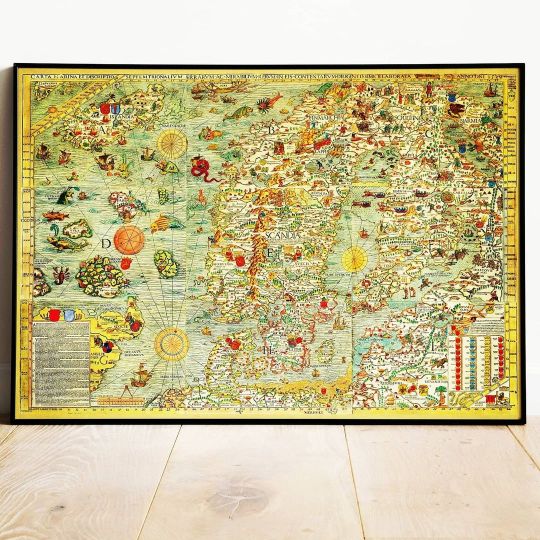
Old Map of Scandinavia, 1539 - Carta Marina by Olaus Magnus – The Medieval Nordic Monster Map - Nordic Countries Denmark, Sweden, Finland #cartamarina #scandinaviamap #medievalnordicmap #ancientmap #finlandmap #swedenmap #icelandmap #olausmagnus https://etsy.me/3tGEMtT (at Scandinavia) https://www.instagram.com/p/CNzqk1Nh1PG/?igshid=1lwice6ji4f4w
#cartamarina#scandinaviamap#medievalnordicmap#ancientmap#finlandmap#swedenmap#icelandmap#olausmagnus
0 notes
Photo

Are you missing traveling to?
⠀⠀⠀⠀⠀⠀⠀⠀⠀
Why not hang a big vintage map and dream about future trips to faraway places, like this beautiful and colourful map of ICELAND.
⠀⠀⠀⠀⠀⠀⠀⠀⠀
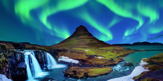
Iceland, a nordic island, is a place of surreal beauty.
The incredible landscape of the island is staggering.
Most of the country is an uninhabited moonscape of craters, bright green moss, towering glaciers, volcanoes, hot springs, and fields of lava rock. Icelandic nature is so diverse and beautiful that it has inspired and influenced people for years.
⠀⠀⠀⠀⠀⠀⠀⠀⠀
Old Maps Library reprint map of ICELAND.
A Physical-Political Island map, Landslagsuppdrattur (Fysik Kort, Physical Map).
The map includes topography, hydrography, vegetation, human features, and internal political boundaries, by V.Richters, Samuel Eggertsson & Danish General Staff. YEAR: 1928
.
.
.
.
.
.
#oldmap #vintagemap #raremap #iceland #icelandmap #cartographer #antiquemap #ancientmap #gallerywalldecor #mapas #instamap #mapdecor #mapsarecool #mapsofinstagram #mapsandillustrations #homedecorationideas #maplove #lovemaps #mapshop #mapsoftheworld #oldword #antiquemapsandprints #framedmaps #map #mapart #wallframe #mapprints #mappe #oldmapslibrary #mapasantiguos (at London, Unιted Kingdom)
https://www.instagram.com/p/CFw3yT-pY_Q/?igshid=1xdkbg6nggsgu
#oldmap#vintagemap#raremap#iceland#icelandmap#cartographer#antiquemap#ancientmap#gallerywalldecor#mapas#instamap#mapdecor#mapsarecool#mapsofinstagram#mapsandillustrations#homedecorationideas#maplove#lovemaps#mapshop#mapsoftheworld#oldword#antiquemapsandprints#framedmaps#map#mapart#wallframe#mapprints#mappe#oldmapslibrary#mapasantiguos
0 notes
Text
Iceland Travel Tips
Iceland is the most beautiful and attractive place in the world, which attracts travelers. It makes lovely memories for a lifetime.
https://eventsvelly.com/iceland-travel-tips/
0 notes
Photo

1572 Ortelius Map of the Arctic (Scandinavia, Iceland, Greenland) https://www.geographicus.com/P/AntiqueMap/septentrionaleregionum-ortelius-1572 One of Abraham Ortelius' most interesting maps, this is his 1572 map of the Arctic, here in its rare second state. The map covers the northern regions from the English Channel to the just south of the North Pole and from America to Russia, including England, Scandinavia, Finland, Denmark, Iceland, and Greenland, as well as parts of America (Estotiland), the apocryphal island of Friesland, and Mercator's speculative Arctic islands. #geographicus #raremap #raremaps #antiquemaps #antiquemap #LI #ortelius #arcticmaps #icelandmaps (at Geographicus Rare Antique Maps)
0 notes
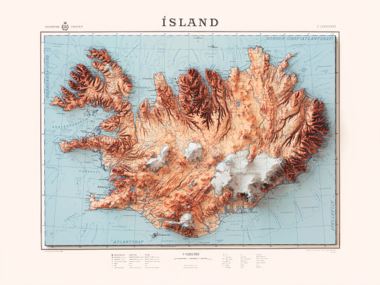
Text
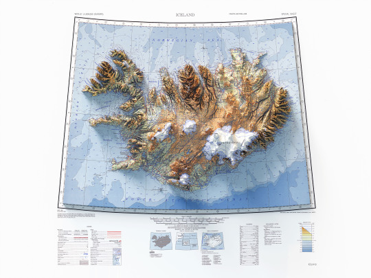
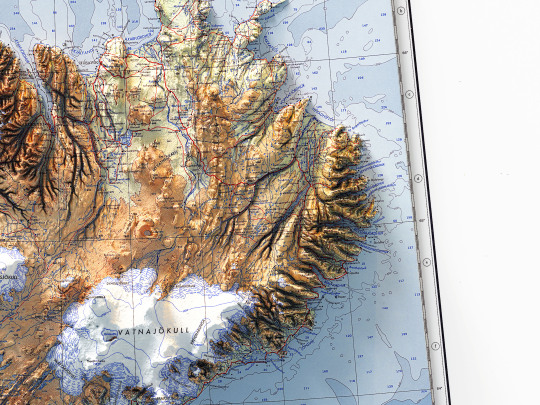
It has finally arrived, beautiful and bright as a northern sunrise😝!
The shaded relief map of Iceland made from a 1952 vintage topographic map.
As mentioned earlier, we had started this work some time ago, and it was put on hold because life at Vizart Studio is sometimes really difficult to menage.
Anyway we finalize it and you can find it on vizcart store!
🗺️ 𝗠𝗔𝗣 𝗜𝗡𝗙𝗢
Topographic map of Iceland showing roads, tracks, boundaries, glaciers, water features, cities and towns. AMS 1301, fouth edition. Prepared by Army Map Service, Corps of Engineers, U.S. Army.
Compiled in 1952 from medium scale of Iceland.
Source: University of Texas
If you like our work, want to see our daily updates (or want to say hello to our studio), consider to follow our Instagram or Twitter account. Otherwise if are interested in our prints or have a custom request check our shop.
#dataviz#3dart#cartographyart#geographyart#mapart#artprint#reliefmap#iceland#icelandmap#geography#topography#cartography#artofinstagram#rendering#maps#icelandart#icelandtravel#icelandlove#mapstagram#blender#b3D#gis#qgis#cycles#photoshopart#postproduction
4 notes
·
View notes
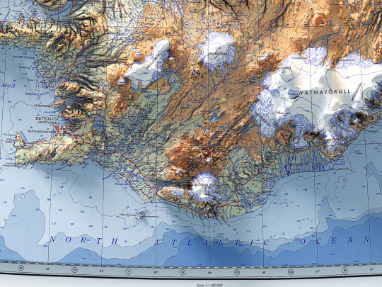
Text
Here we are with the last map of Iceland of this week. It is a topographic map printed and published by Geodetic Institute of Denmark in 1963.
🗺️ 𝗠𝗔𝗣 𝗜𝗡𝗙𝗢
Topographic map of Iceland, 1:1000000, published and printed by Geodetic Institute (Denmark), 1963.
If you like our work, want to see our daily updates (or want to say hello to our studio), consider to follow our Instagram or Twitter account. Otherwise if are interested in our prints or have a custom request check our shop.
#dataviz#3dart#cartographyart#geographyart#mapart#artprint#reliefmap#homedecor#posterart#iceland#icelandmap#geography#artofinstagram#walldecor#maps#icelandart#icelandtravel#icelandlove
2 notes
·
View notes
Photo

- Click Photo for Details - ★ Website ➔ www.InkistPrints.com ★ Etsy Store ➔ www.InkistPrints.etsy.com
#ChristmasGift#ReykjavikMap#IcelandPoster#BabyGift#ChildrenRoom#LivingRoomDecor#IcelandMap#WallArt#ArtPrint#Poster#NurseryDecor#ReykjavikPrint#MapPrint#babygift#weddingifts#giftforher#wallart#homedecor#valentinesdaygifts#poster
1 note
·
View note
Photo

- Click Photo for Details - Prices from $9.95 - Buy 2, Get 3rd FREE ★ Website ➔ www.InkistPrints.com ★ Etsy Store ➔ www.InkistPrints.etsy.com ★ Check Out Our Various Collection Pages ★ - Watercolor Art: http://etsy.me/2Lh618W - Watercolor Skyline: http://etsy.me/2UL5HTU - Watercolor Map: http://etsy.me/2EtNqpl - Disneyland: http://etsy.me/2BdChVI - Butcher’s Guide: http://etsy.me/2BfgtJd - Typography Map: http://etsy.me/2BlorAS - Typography: http://etsy.me/2PCSqZR - Customize Name: http://etsy.me/2QMFPIr - Nursery Decor: http://etsy.me/2Caxvdp - World Map: http://etsy.me/2BjE7od - USA Street Map: http://etsy.me/2EsIZeB - CANADA Street Map: http://etsy.me/2ryxmdz - EUROPE Street Map: http://etsy.me/2LekFh9 - FOREIGN Street Map: http://etsy.me/2RXXVo8
#ModernArt#IcelandMap#IcelandDecor#ReykjavikMap#IcelandPoster#ArtworkForKitchen#IcelandPrint#BabyRoom#Iceland#WeddingDecor#IcelandStreetMap#ReykjavikArt#Reykjavik#wallart#homedecor#giftidea#gifts#anniversarygifts#anniversary#weddingifts
0 notes
Last Seen Blogs

no-good-needs-questioning
Hmm...

streetstylenyc
matthew leung

hairfalltreatmentchennai
The best Hair Treatment in Chennai

precious-flower-child
Oh Oh Oh It’s✨MaGiC✨

undertheskyfish
skyfish