#mapasantiguos
Explore tagged Tumblr posts
Video
youtube
Existieron civilizaciones avanzadas que desaparecieron -100 Mil años de Historia en descripción - HD
Aunque este vídeo no trate de los Oopart, son mencionados algunos para que comprendan su localización en la escala de tiempo, que suponen y la escala de tiempo admitida Oficialmente, dando así a entender que existen demasiadas cosas que no se cuentan, ni se las toman en cuenta, debido a que descuadran completamente lo oficialmente reconocido, que cada vez, coincida menos con lo que se esta descubriendo con las nuevas tecnologías de la Ciencias Arqueológicas. Se conoce como OOPARTS a los artefactos de interés histórico, arqueológico o paleontológico que se encuentran en un contexto muy inusual o aparentemente imposible de explicar de acuerdo a la cronología histórica convencional. Al fin y al cabo, lo sobrenatural no deja de ser la ciencia que aún no entendemos. Para que todos nos entendamos: algo así como encontrarte un Iphone datado en la época del Pleistoceno, o que en una pintura rupestre salga representado un tío en bicicleta. En un sentido más genérico, también se catalogarían como OOPARTS aquellos hallazgos, no necesariamente arqueológicos, cuya cronología revela un anacronismo El OOPARTS por excelencia, aquel que representa a la perfección lo que supone este fenómeno y que ha acabado siendo reconocido, aunque tímidamente, como verdadero, es el de la máquina de Anticitera. Hay OOPARTS para todos los gustos: pilas babilónicas que se cargaban de electricidad, esferas metálicas de 2800 años de antigüedad, antiquísimos mapas que desafían el conocimiento geográfico de su tiempo… Tomados en serio o no, la mayoría de ellos han sido estudiados obteniendo respuestas más o menos convincentes. En «Cien mil años de historia desconocida» Robert Charroux https://youtu.be/5VjspLcWW64 afirma que algunos secretos, que habrían podido precipitar la evolución de la Humanidad, se han mantenido ocultos durante milenios ante el temor de que su revelación pudiera provocar un cataclismo. En el vídeo, además de ser Audiolibro, podrán ver imágenes, que según la ciencia oficial, niega, pues son mapas que tienen conocimientos imposibles, que conocieran en la época que fueron realizados los Mapas, como detalles increíbles, sobre lugares que no se tuvo conocimiento hasta siglos después de que estos fuesen creados.
En el Blog LOGOS pronto habrá una Publicación con estas imágenes, aparte del Audiolibro que estará también insertado, junto a otros que ya tengo en mente, y unos cuantos PDFs del tema que poseo y los pondré para vuestra descarga. LOGOS https://logosconocimientos.blogspot.com/
#humanidad #manipulación #reseteo #tartaria #atlantida #lemuria #Mu #mundo #mapasimposibles #pirisreis #secreto #imperios #imperiosperdidos #aliens #tecnologiasenlaantiguedad #hindu #continentesdesaparecidos #sociedadessecretas #conocimientosprohibidos #vimanas #rayodelamueerte #tiahuanaco #mapasantiguos #continentesperdidos #extraterrestres #ovnis #atlantis #atlantes #hiperborea #tablillas #genesis #prehistoria #hindues #agarta #esenios #baalbek
0 notes
Photo

Hello Everyone! Do you think is it possible to travel Around the World in 80 Days, just like in the adventure novel of Jules Verne? In the story Phileas Fogg of London and his newly employed French valet Passepartout attempt to circumnavigate the world in 80 days. ⠀⠀⠀⠀⠀⠀⠀⠀⠀ The answer is, Yes! Nowadays with modern flight, going round the world in 80 days wouldn't only be possible, but could be done 40 times over. ⠀⠀⠀⠀⠀⠀⠀⠀⠀ Old Maps Library reprint map of the World on Mercator’s Projection. Revised and Improved to 1817 by John Melish. Published by John Melish & Samil.Harrison. Includes text “To find the distance of one place from another” and statistical table. ⠀⠀⠀⠀⠀⠀⠀⠀⠀ This exquisite World map and many others can be found at our website, link in Bio 🔝 . . . . . . . #maplove #lovemaps #mapshop #mapsoftheworld #oldword #antiquemapsandprints #oldmapslibrary #mapasantiguos (at London, Unιted Kingdom) https://www.instagram.com/p/ChSh8DUod5i/?igshid=NGJjMDIxMWI=
0 notes
Photo
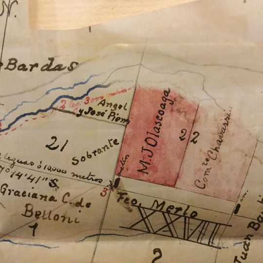
Mapa manuscrito catastral del premio concedido al expedicionario del desierto Manuel J Olascoaga en Neuquén. 1894. #conquistadeldesierto #olascoaga #manuelolascoaga #guerraalindio #mapasantiguos #libreriaanticuaria #neuquen (en Ciudad Autónoma de Buenos Aires) https://www.instagram.com/p/CCrPSzIpSAy/?igshid=3wzkww6re26o
#conquistadeldesierto#olascoaga#manuelolascoaga#guerraalindio#mapasantiguos#libreriaanticuaria#neuquen
0 notes
Photo

📢¡¡¡Aviso para navegantes despistados!!! ¿Conocéis la historia de Isla Escondida? CORRED A YOUTUBE a encontrar el mapa del tesoro y no quedéis atrapados entre raíces pinchonas!!!😂😆🌵🌵🌵 . ➡️¡¡¡Link en bio!!!⬅️ . https://youtu.be/pcd0OotW1K0 . 🤩¿Te animas a hacer tu propio mapa? ¿Quieres crear tu propia historia? ¿Quieres crear un juego? Encontrarás mucha inspiración en mi canal de youtube. Corre! No te lo pierdas! . . . #mapasantiguos #mapaantiguo #mapadeltesoro #mapas #mapa #vintagemap #vintagepaper #vintageephemera #vintage #isladeltesoro #pergamino #papeleriabonita #diy https://www.instagram.com/p/B2esVOwoGB4/?igshid=1radgzxvo7p7v
#mapasantiguos#mapaantiguo#mapadeltesoro#mapas#mapa#vintagemap#vintagepaper#vintageephemera#vintage#isladeltesoro#pergamino#papeleriabonita#diy
0 notes
Photo

Hijos en la #eso ¿examen #historiadeespaña #conquistaespañolas quién fue #felipeII y #carlosv Sabíais que en los #mapasantiguos aparecían las #rosadelosvientos para guiarse en la #navegacion Os dejo esta #infografia #ilustracion publicada en #historia de la editorial #apyce https://www.instagram.com/p/Bx9eG6koADm/?igshid=lfsf0baxkzrf
#eso#historiadeespaña#conquistaespañolas#felipeii#carlosv#mapasantiguos#rosadelosvientos#navegacion#infografia#ilustracion#historia#apyce
0 notes
Photo

Trabajar con mapas antiguos tiene un cierto encanto. Preparar la información contenida en ellos para adecuarla a la actualidad, georreferenciarlos, cotejarlos con ortofotos de época cercana a la del plano... Es un trabajo de investigación muy gratificante cuando ves el resultado. #mapas #mapasantiguos #parcelario #retintado #georeferencia #georeferenciacion #trabajando #work #maps #oldmaps #ed50 #etrs89 #etrs89utm30 https://ift.tt/37R8oJg
0 notes
Text
Referencias para mapas de fantasía
Voy a compartir algunas páginas que pueden servir como referencias para elaborar nuestros mapas de fantasía, la mayoría son antiguos porque creo que la mayoría tomamos inspiración de ellos, pero he incluido algunas páginas con cosillas curiosas, si alguien conoce más páginas interesantes, que se anime a compartirlas :D.
En la imagen: no la Tierra Media
El archivo del IGN que tiene un poco de todo:
Mapas antiguos
http://www.ign.es/fondoscartograficos/
Planos ligeramente más modernos
http://www.ign.es/web/mapasantiguos
Geoinstitutos:
http://www.geoinstitutos.com/carto-anti.asp
Una bonita colección personal:
http://www.coleccioncartografiagm.com/7-mapas-regionales
La Wikipedia en inglés de Mapamundis antiguos tiene un buen número de ejemplos:
https://en.wikipedia.org/wiki/Early_world_maps
La Librería del Congreso, con un mucho de todo también, incluidos planos militares:
https://www.loc.gov/maps/collections/
La cuenta de tuiter sobre mapas del National Geographic es una de mis cuentas favoritas para todo tipo de curiosidades (tienen otras cuentas, pero yo les sigo en tuiter):
https://twitter.com/mapdragons
Y como curiosidad final, el considerado mapa más antiguo del mundo:
http://arqueologianavarra.blogspot.com.es/2011/06/museo-de-navarra-la-cueva-de-abauntz.html
Hace tiempo tenía una página muy interesante con ciudades retrofuturistas y otra con planos de parques de atracciones, pero las he perdido, son mapas muy diferentes a lo que se suele ver en la mayor parte de la fantasía y el cifi convencional, y estoy segura de que pueden despertar la imaginación de alguien, si consigo dar con esas páginas otra vez intentaré añadirlas a las referencias 🙂
Referencias para mapas de fantasía was originally published on La Máquina de Escribir
0 notes
Photo
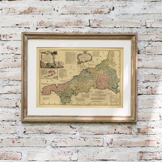
A gorgeous map of this beautiful English County, CORNWALL.
Cornwall is a county on England’s rugged southwestern tip. It is famous for being a seaside paradise with stunning beaches and lush countryside. Cornwall is also known for being home to Cornish Cream Tea and Cornish Pasties and surfing! It also has its own language, Kernowek.
Old Maps Library, 2022 fine reproduction map of Cornwall, circa 1775 by Thomas Kitchin. This map was from the best surveys & intelligence divided into its hundreds showing the several roads and true measured distance between town & town also the rectories and vicarages the parks & seats of the nobility & gentry with other useful particulars. Regulated by astronomical observations. ⠀⠀⠀⠀⠀⠀⠀⠀⠀
#oldmap#vintagemap#homedecorationideas#maplove#lovemaps#mapshop#mapsoftheworld#oldword#oldmapslibrary#mapasantiguos
0 notes
Photo

Happy Friday!
This weekend we are celebrating the Queen's Platinum Jubilee in England! Her Majesty The Queen is the first royal to celebrate this special date, 70 years as a monarch. Long Live the Queen 👑🇬🇧
A reprint map of Great Britain & Ireland, drawn by Thomas Kitchin, Geographer. The map has a decorative cartouche with Britannia seated below, her outstretched hands indicating the cornucopia of plenty below her, left, the barrels, scythe, the garlanded youth holding a scroll with a ship on it, an anchor in the background and to right, a sailing ship and castle – all indicating the prestige, might and plenty of the kingdom. Three scales of Distance bottom left (British Statute Miles, Common Scotch Miles, Irish Miles), reference key to the counties of Ireland middle left, Explanation key top right showing symbols for roads, markets, etc in England, Scotland and Ireland. Reference to the Shires of Scotland top right and below to the Counties of England and Wales.
Original map published by Laurie & Whittle, London, 1794.
"Travel back to moments in time and discover the world heritage!" ⠀⠀⠀⠀⠀⠀⠀⠀⠀
0 notes
Photo
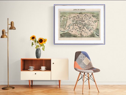
Bonjour! Happy Friday! ⠀⠀⠀⠀⠀⠀⠀⠀⠀ "We'll always have Paris," - One of the most memorable lines in film comes from the 1942 classic Casablanca, when the cynical ex-pat Rick tells his former lover Ilsa: “We'll always have Paris.” Rick is referring to their brief romance on the eve of World War II—a courtship that ended abruptly with the Nazi invasion of France. ⠀⠀⠀⠀⠀⠀⠀⠀⠀ Travel to Paris with this beautifully reprint map from 1878 by Garnier Frères. ⠀⠀⠀⠀⠀⠀⠀⠀⠀ Nouveau Paris Monumental. Itinéraire Pratique de L’Etranger Dans Paris. A fine reproduction map of Paris illustrating famous monuments. This map was produced as a tourist guide in the late 1800s. ⠀⠀⠀⠀⠀⠀⠀⠀⠀ ⏳ ⠀⠀⠀⠀⠀⠀⠀⠀⠀ "Travel back to moments in time and discover the world heritage!" ⠀⠀⠀⠀⠀⠀⠀⠀⠀ ⠀⠀⠀⠀⠀⠀⠀⠀⠀ ⏳Old Maps Library specialises in the reprint of Vintage Maps and Illustrations between the 17th to 19th centuries. ⠀⠀⠀⠀⠀⠀⠀⠀⠀ ⠀⠀⠀⠀⠀⠀⠀⠀⠀ ⏳ We have a beautiful collection of Old Maps and Vintage Illustrations on our website. Link on our bio. ⠀⠀⠀⠀⠀⠀⠀⠀⠀ . . . #mapas #instamap #mapdecor #mapsarecool #mapsofinstagram #citymaps #parismap #oldmapslibrary #mapasantiguos (at London, Unιted Kingdom) https://www.instagram.com/p/CdOJ-lsOTu1/?igshid=NGJjMDIxMWI=
0 notes
Photo

Happy Friday! “There’s something about arriving in new cities, wandering empty streets with no destination. I will never lose the love for the arriving, but I’m born to leave.” - Charlotte Eriksson - ⠀⠀⠀⠀⠀⠀⠀⠀⠀ Map of TASMANIA, John Tallis. This is an impressive 1851 Tallis map of Van Diemen’s Island or Tasmania. The map covers the entire island of Tasmania in considerable detail noting towns, lakes, mountain ranges, and other topographical features. It includes illustrations by H. Warren of Hobart Town, a Tasmania dog, and the residence of the Van Diemen Land Company’s Agent. This map was issued as part of the 1851 edition of John Tallis and Company’s The Illustrated Atlas, And Modern History of the World. ⠀⠀⠀⠀⠀⠀⠀⠀⠀ Old Maps Library reprint, 2022. ⠀⠀⠀⠀⠀⠀⠀⠀⠀ We have many more old maps & vintage illustrations on our website. Visit us ☞ www.oldmapslibrary.com . . #oldmap #ancientmap #mapsarecool #mapsofinstagram #mapsandillustrations #homedecorationideas #maplove #lovemaps #mapshop #mapsoftheworld #oldmapslibrary #mapasantiguos (at London, Unιted Kingdom) https://www.instagram.com/p/CasEUKOIo75/?utm_medium=tumblr
#oldmap#ancientmap#mapsarecool#mapsofinstagram#mapsandillustrations#homedecorationideas#maplove#lovemaps#mapshop#mapsoftheworld#oldmapslibrary#mapasantiguos
0 notes
Photo

😍🤩¡¡¡NUEVO VÍDEO EN YOUTUBE!!! Link en bio!!! Cómo hacer un MAPA del TESORO!!! Os doy ideas para crear vuestro propio mapa. Cómo envejecer el papel, cómo dibujarlo, cómo decorarlo, y mucho más. CORRE A VER LA HISTORIA DE ISLA ESCONDIDA!!! . . . #mapa #mapadeltesoro #mapas #mapasantiguos #isladeltesoro #vintagepaper #oldpaper #treasuremap #juegosderol #laisladeltesoro #vintage https://www.instagram.com/p/B2bk85qoLab/?igshid=1r8q4haqugmcj
#mapa#mapadeltesoro#mapas#mapasantiguos#isladeltesoro#vintagepaper#oldpaper#treasuremap#juegosderol#laisladeltesoro#vintage
0 notes
Photo

Happy Friday! Enjoy your weekend discovering world history with an old map. ⠀⠀⠀⠀⠀⠀⠀⠀⠀ Old Maps Library reprint map of Modern Palestine. Illustrations drawn by H.Warren & Engraved by R.Baker and Map drawn & engraved by J.Rapkin. This map has outline color by region with drawings of pelicans, a gazelle, natives, and two cities - Jaffa and Nazareth. Delicate design encloses the map. ⠀⠀⠀⠀⠀⠀⠀⠀⠀ ⏳ ⠀⠀⠀⠀⠀⠀⠀⠀⠀ ⏳ Old Maps Library specialises in the reprint of Vintage Maps and Illustrations between the 17th to 19th centuries. ⠀⠀⠀⠀⠀⠀⠀⠀⠀ 🔎 Our prints are linen backed by hand, this technique gives it more durability and a beautiful vintage finish look. ⠀⠀⠀⠀⠀⠀⠀⠀⠀ ⏳Linen backing is a technique that mapmakers used in the past as a solution to keep the maps stronger for long journeys and weather changes. ⠀⠀⠀⠀⠀⠀⠀⠀⠀ 🔎Nowadays, this technique is an important conservation method for restoring and preserving vintage maps and posters. ⠀⠀⠀⠀⠀⠀⠀⠀⠀ ⏳Our maps are folded and fitted into a marbled slipcase. ⠀⠀⠀⠀⠀⠀⠀⠀⠀ ⏳ ⠀⠀⠀⠀⠀⠀⠀⠀⠀ Are you also fascinated by old maps? ⠀⠀⠀⠀⠀⠀⠀⠀⠀ ⏳ We have a beautiful collection of Old Maps and Vintage Illustrations on our website. Link in our bio. ⠀⠀⠀⠀⠀⠀⠀⠀⠀ "Travel back to moments in time and discover the world heritage!" . . . #oldmap #vintagemap #raremap #location #mapnameyear #cartographer #antiquemap #ancientmap #gallerywalldecor #mapas #instamap #mapdecor #mapsarecool #mapsofinstagram #mapsandillustrations #homedecorationideas #maplove #lovemaps #mapshop #mapsoftheworld #oldword #antiquemapsandprints #framedmaps #map #mapart #wallframe #mapprints #mappe #oldmapslibrary #mapasantiguos (at London, Unιted Kingdom) https://www.instagram.com/p/CQ1INJyt3U7/?utm_medium=tumblr
#oldmap#vintagemap#raremap#location#mapnameyear#cartographer#antiquemap#ancientmap#gallerywalldecor#mapas#instamap#mapdecor#mapsarecool#mapsofinstagram#mapsandillustrations#homedecorationideas#maplove#lovemaps#mapshop#mapsoftheworld#oldword#antiquemapsandprints#framedmaps#map#mapart#wallframe#mapprints#mappe#oldmapslibrary#mapasantiguos
2 notes
·
View notes
Photo
Happy Wednesday!
⠀⠀⠀⠀⠀⠀⠀⠀⠀
Shall we take another journey back in time through an old map?
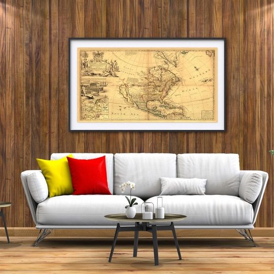
We have today this beautiful reproduction map of North America by Herman Moll, circa 1719.
⠀⠀⠀⠀⠀⠀⠀⠀⠀
One of Herman Moll’s most famous maps often referred to as The Codfish Map.
⠀⠀⠀⠀⠀⠀⠀⠀⠀
As an enhancement to his “Map of North America,” Moll engraved orthographic or plan views of ten bays in North America and the Caribbean in the lower left-hand corner of the map. ⠀⠀⠀⠀⠀⠀⠀⠀⠀
Each bay was the location of a major port city and harbour. ⠀⠀⠀⠀⠀⠀⠀⠀⠀
Five of the port cities were British (St. John’s, Boston, New York, Charleston, and Port Royal) and five were Spanish (Havana, Portobello, Vera Cruz, Cartagena, and Acapulco). ⠀⠀⠀⠀⠀⠀⠀⠀⠀
Moll engraved the insets in the style of navigational charts complete with numbers on some of the charts representing depth soundings in fathoms.
⠀⠀⠀⠀⠀⠀⠀⠀⠀
Herman Moll (1654?-1732) was a London cartographer, engraver, and publisher. ⠀⠀⠀
⠀⠀⠀⠀⠀⠀⠀⠀⠀
Visit our online shop for more old maps & Vintage Illustrations.
⠀⠀⠀⠀⠀⠀⠀⠀⠀
Link in Bio
.
.⠀⠀⠀⠀⠀⠀
.
#oldmap #vintagemap #raremap #northamericamap #mapofnorthamerica #cartographer #antiquemap #ancientmap #gallerywalldecor #mapas #instamap #mapdecor #mapsarecool #mapsofinstagram #mapsandillustrations #homedecorationideas #maplove #lovemaps #mapshop #mapsoftheworld #oldword #antiquemapsandprints #framedmaps #map #mapart #wallframe #mapprints #mappe #oldmapslibrary #mapasantiguos (at London, Unιted Kingdom)
https://www.instagram.com/p/CLcDgt5pmNZ/?igshid=q84prq89pwf4
#oldmap#vintagemap#raremap#northamericamap#mapofnorthamerica#cartographer#antiquemap#ancientmap#gallerywalldecor#mapas#instamap#mapdecor#mapsarecool#mapsofinstagram#mapsandillustrations#homedecorationideas#maplove#lovemaps#mapshop#mapsoftheworld#oldword#antiquemapsandprints#framedmaps#map#mapart#wallframe#mapprints#mappe#oldmapslibrary#mapasantiguos
1 note
·
View note
Photo

NUEVO VÍDEO!!!LINK EN MI BIO @annfriks Os cuento tres técnicas para envejecer papel con té, con café o con distress ink!!! Si os gustan las cositas #vintage, con estas técnicas podréis envejecer cualquier papel y hacer vuestros propios #pergaminos #mapasantiguos #sobres . . . #envejecer #papel #oldpaper #annfriks #tecnicasdeenvejecido
0 notes
Photo
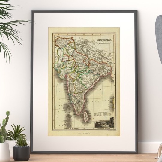
Happy Thursday! ⠀⠀⠀⠀⠀⠀⠀⠀⠀ A gorgeous reprint map of India, 1824, by James Wyld. A detailed map, with outline coloured boundaries, also a vignette “View of Calcutta from Ft. William”. Includes reference to colors, showing provinces, and settlements. Drawn by J.Wyld. (engraved by) Hewitt Sc. … Published by John Thomson & Co. Edinburgh. ⠀⠀⠀⠀⠀⠀⠀⠀⠀ The name "India" is originally derived from the name of the river Sindhi (Indus River) and has been in use in Greek since Herodutus (4th century BCE). ⠀⠀⠀⠀⠀⠀⠀⠀⠀ But, did you know that India is know by other names too? Jambudwwepa, Al-Hind, Hindustan, Tenjiku, Aryavarta, and Bharat. One country, many names! ⠀⠀⠀⠀⠀⠀⠀⠀⠀ ⏳Old Maps Library specialises in the reprint of Vintage Maps and Illustrations between the 17th to 19th centuries. ⠀⠀⠀⠀⠀⠀⠀⠀⠀ ⏳ We have a beautiful collection of Old Maps and Vintage Illustrations on our website. Link on our bio. ⠀⠀⠀⠀⠀⠀⠀⠀⠀ "Travel back to moments in time and discover the world heritage!" . . . #oldmap #vintagemap #raremap #indiamap #mapofindia #antiquemap #ancientmap #mapas #instamap #mapdecor #mapsarecool #mapsofinstagram #mapsandillustrations #maplove #lovemaps #mapshop #mapsoftheworld #antiquemapsandprints #framedmaps #map #mapart #wallframe #mapprints #oldmapslibrary #mapasantiguos (at London, Unιted Kingdom) https://www.instagram.com/p/CZhJzsZNI4v/?utm_medium=tumblr
#oldmap#vintagemap#raremap#indiamap#mapofindia#antiquemap#ancientmap#mapas#instamap#mapdecor#mapsarecool#mapsofinstagram#mapsandillustrations#maplove#lovemaps#mapshop#mapsoftheworld#antiquemapsandprints#framedmaps#map#mapart#wallframe#mapprints#oldmapslibrary#mapasantiguos
0 notes