#GeographicInformation
Explore tagged Tumblr posts
Visit Tumblr Blog
Explore Tumblr blogs with no restrictions, modern design and the best experience.
Last Seen Tumblr Blogs


Fun Fact
The KCSC sent more than 20K requests to delete posts related to prostitution and porn to Tumblr from January to June 2017.
Text
Google Earth is a digital globe that lets users explore detailed satellite imagery, maps, and 3D terrain of the Earth. It offers virtual tours, street-level views, and geographic information, making it a powerful tool for education, travel, and exploration. Discover the world from your screen.

#GoogleEarth#SatelliteImagery#VirtualTour#Maps#GeographicInformation#3DTerrain#StreetView#Exploration#Travel#DigitalGlobe#Geography#Mapping#GlobalExploration
2 notes
·
View notes
Text

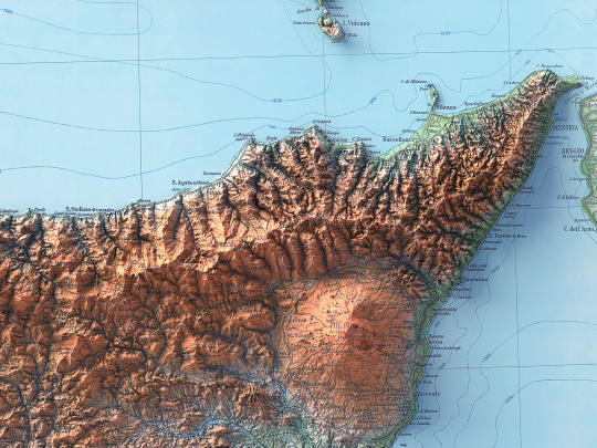


With this map, one of the last for the time being dedicated to Italy, we return a little to the beginning by presenting the island of Sicily, of which we have already published a soil map from 1967.
This map required a longer intervention because it was split in half and ruined by time, being a document from 1943. We chose to leave behind the dusty look of an archive document and give it new life with a stronger colouring.
🗺️ 𝗠𝗔𝗣 𝗜𝗡𝗙𝗢 Isola di Sicilia, prepared and published by Istituto Geografico Militare (Florence) in 1943. Source: Gallica BNF
If you like our work, want to see our daily updates (or want to say hello to our studio), consider to follow our Instagram or Twitter account. Otherwise if are interested in our prints or have a custom request check our shop.
#ShadedReliefMap#Cartography#VintageMap#HistoricalMap#MapRestoration#IsleOfSicily#SicilyHistory#sicily#MapCollectors#MapEnthusiast#Geography#MapArt#AntiqueMap#MapGeeks#ArtOfMaps#ThrowbackMap#GeographicFeatures#SicilyExploration#GeographicInformation#MapDiscoveries#dataviz#italytravel#sicily italy#sicilia#south italy
2 notes
·
View notes
Text
Information
Watch video on YouTube:
https://youtu.be/461BL-pjOnY
#Geographic #GeographicInformation #Info #Information #GeneralInformation #Culture #Knowledge #GeneralCulture #GeneralKnowledge #General #MainInformation #Illustrated #Images #InspiringMinds #Inspiration #Mind
0 notes
Photo

Vintage map in QGIS Link in BIO . . . #mapmaker #mapping #mappingingis #mapporn #vintage #vintagemap #vintagemaps #qgis #gismappingtraining #gis #geomatics #engineering #surveylife #mapstagram #cartografia #cartography #geografia #geographicinformation #geography #topography #topo #fun #youtubers #youtube #subscribetomychannel (at Baciu, Cluj) https://www.instagram.com/p/CKY64k1jKzZ/?igshid=1sahdqg5yydaf
#mapmaker#mapping#mappingingis#mapporn#vintage#vintagemap#vintagemaps#qgis#gismappingtraining#gis#geomatics#engineering#surveylife#mapstagram#cartografia#cartography#geografia#geographicinformation#geography#topography#topo#fun#youtubers#youtube#subscribetomychannel
1 note
·
View note
Text
im fr retarded for studying hub science and philosophy like....... but also the smartestest bc i accidentally (?) (on purposedly without knowing how right i was) picked the easiest major/minor combo. so now im done but actually sociology papers make me wanna break things and philosophy papers are so stupid i wont write them. and psychology papers arent actually that bad i just dont know how to read to i pull my hair out for a month tryng to research n then just kinda poop it out last minute.... so i finally realize it wuldve been easier, more interesting, more Hire-able for ME to just study geographicinformation systems instead the whole time....... -_- whateva son thats what masters degreese is for :D #LOVELIFE #POSITIVEGRINDSET
0 notes
Text
Geographic Information Organization Access And Use

Geographic Information Organization Access And Use, Author: BISHOP W, Publish Year: October 2016, Discount: 23.00%, Price: ₹ 8528.00, ISBN 9783319227887, Publisher: SPRINGER
Geographic Information Organization Access And Use by BISHOP W, Buy Books Online, Buy Environmental Technology & Management Books Online, Buy Professional Books, Technical Bookstore, Online Book Store, Best Book Seller in India
#GeographicInformationOrganizationAccessAndUse #BISHOP W #SPRINGER #EnvironmentalTechnologyandManagementBooks #GeographicInformation #Discount #FreeShipping #OnlineBookStore
For More Details Or To Buy Visit@ http://bit.ly/2LiECDD
0 notes
Photo

ArcGis 10.8 Pre release version #arcgis #arcgis10 #arcgis10.8 #geo #gis #geographicinformation #information #system #gismapping #geographicinformationsystems #geomaticsengineering #engineering #surveylife #surveying #orange #mapping #maps #earth #globe #arcgis #qgis #geography #topo #topography #trending (at Baciu, Cluj) https://www.instagram.com/p/B-9L-9AjHd3/?igshid=ugzmi1c1lql9
#arcgis#arcgis10#geo#gis#geographicinformation#information#system#gismapping#geographicinformationsystems#geomaticsengineering#engineering#surveylife#surveying#orange#mapping#maps#earth#globe#qgis#geography#topo#topography#trending
1 note
·
View note
Photo
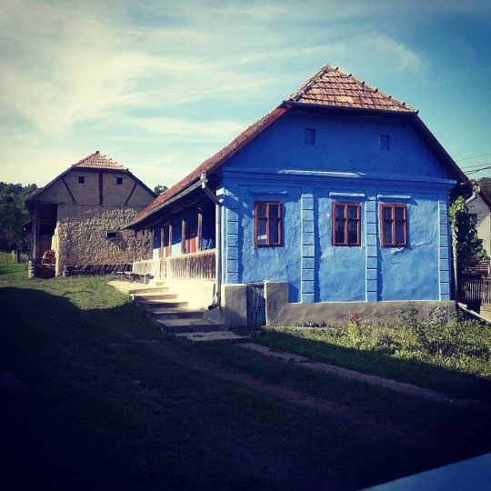
Architecture #architecture #architecturephotography #architectural #old #oldhouse #beautyful #transylvania #geomaticsengineering #geographicinformation #engineering #house https://www.instagram.com/p/CD12CTHDD7q/?igshid=jwmzodm1l9y6
#architecture#architecturephotography#architectural#old#oldhouse#beautyful#transylvania#geomaticsengineering#geographicinformation#engineering#house
0 notes
Photo

Using ArcGIS to Determine the Energy of Relief – Mapping in GIS #arcgis #arcgis10 #arcgis10.8 #geo #gis #geographicinformation #information #system #gismapping #geographicinformationsystems #geomaticsengineering #engineering #surveylife #surveying #orange #mapping #maps #earth #globe #arcgis #qgis #geography #topo #topography #trending #google #gooleearth #relief #energy (at Cluj-Napoca) https://www.instagram.com/p/CC3gUoADUJh/?igshid=ni3u07oe4dng
#arcgis#arcgis10#geo#gis#geographicinformation#information#system#gismapping#geographicinformationsystems#geomaticsengineering#engineering#surveylife#surveying#orange#mapping#maps#earth#globe#qgis#geography#topo#topography#trending#google#gooleearth#relief#energy
0 notes
Photo

9 Best Sources to Download FREE Land Cover and Land Use Data – Mapping in GIS #arcgis #geo #gis #geographicinformation #information #system #gismapping #geographicinformationsystems #geomaticsengineering #engineering #surveylife #surveying #orange #mapping #maps #earth #globe #arcgis #qgis #geography #topo #topography #trending #google #gooleearth #landscapephotography #landscape #landcover #landusedata (at Baciu, Cluj) https://www.instagram.com/p/B_Mz7IujaHR/?igshid=1rzr9qahz7qkt
#arcgis#geo#gis#geographicinformation#information#system#gismapping#geographicinformationsystems#geomaticsengineering#engineering#surveylife#surveying#orange#mapping#maps#earth#globe#qgis#geography#topo#topography#trending#google#gooleearth#landscapephotography#landscape#landcover#landusedata
0 notes
Photo
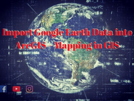
Import Google Earth Data into ArcGIS – Mapping in GIS Import Google Earth Data into ArcGIS – Mapping in GIS 1. Open Google Earth 2. Search for a place 3. Save that place KML format 4. Open ArcMap. Go to View Data Frame Properties and select the Coordinate System tab. Choose Predefined Geographic Coordinate Systems World WGS 1984. KML is Google's Keyhole Markup Language, KML is a file format used to display geographic data in an Earth browser such as Google Earth. KML uses a tag-based structure with nested elements and attributes and is based on the XML standard. In this Tutorial you will learn about that How to import Google Earth data into ArcGIS as a Shapefile. So this is very easy method to convert KML to Shapefile in GIS This video illustrates how to import a image from Google Earth into ArcMap #arcgis #arcgis10 #arcgis10.8 #geo #gis #geographicinformation #information #system #gismapping #geographicinformationsystems #geomaticsengineering #engineering #surveylife #surveying #orange #mapping #maps #earth #globe #arcgis #qgis #geography #topo #topography #trending #google #googleearth (at Baciu, Cluj) https://www.instagram.com/p/B_DhzvXjtdG/?igshid=1slrmeqoipzvh
#arcgis#arcgis10#geo#gis#geographicinformation#information#system#gismapping#geographicinformationsystems#geomaticsengineering#engineering#surveylife#surveying#orange#mapping#maps#earth#globe#qgis#geography#topo#topography#trending#google#googleearth
0 notes
Photo
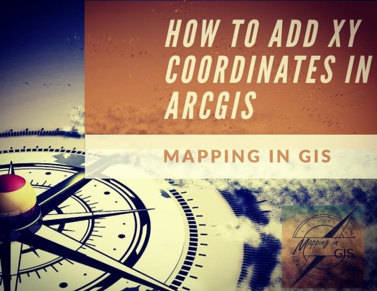
How to add XY cordinates in Arcgis Link in BIO: https://youtu.be/pkdPzcnvp00 #coordinates #geomatics #gisday #gismapping #utm #universal #transverse #mercator #geo #gis #geographicinformation #information #system #gismapping #geographicinformationsystems #geomaticsengineering #engineering #surveylife #surveying #orange #mapping #maps #earth #globe #arcgis #qgis #geography #topo #topography #trending #compass (at Cluj-Napoca) https://www.instagram.com/p/B8hBJM8hT3Q/?igshid=12nnn5j8degfa
#coordinates#geomatics#gisday#gismapping#utm#universal#transverse#mercator#geo#gis#geographicinformation#information#system#geographicinformationsystems#geomaticsengineering#engineering#surveylife#surveying#orange#mapping#maps#earth#globe#arcgis#qgis#geography#topo#topography#trending#compass
0 notes
Photo

Unitāți de măsură! #gisday #geomatics #gismapping #geomaticsengineering #gismappingtraining #gis #globe #geo #geographicinformation #geography #geographicinformationsystems #gisengineering #mapping (at Cluj-Napoca) https://www.instagram.com/p/B8S5e8NBqCn/?igshid=1e9ax3jazgnuv
#gisday#geomatics#gismapping#geomaticsengineering#gismappingtraining#gis#globe#geo#geographicinformation#geography#geographicinformationsystems#gisengineering#mapping
0 notes
Photo

For the first time in 909 years, today is a global palindrome (reads the same backwards as it does forwards). There won’t be another one for 101 years! #geo #gis #geographicinformation #information #system #gismapping #geographicinformationsystems #geomaticsengineering #engineering #surveylife #surveying #orange #mapping #maps #earth #globe #arcgis #qgis #geography #topo #topography #trending #palindrome (at Baciu, Cluj) https://www.instagram.com/p/B8FBkNMB-CW/?igshid=r18au1xw6x9b
#geo#gis#geographicinformation#information#system#gismapping#geographicinformationsystems#geomaticsengineering#engineering#surveylife#surveying#orange#mapping#maps#earth#globe#arcgis#qgis#geography#topo#topography#trending#palindrome
0 notes
Photo

Universal Transverse Mercator (UTM) #utm #universal #transverse #mercator #geo #gis #geographicinformation #information #system #gismapping #geographicinformationsystems #geomaticsengineering #engineering #surveylife #surveying #orange #mapping #maps #earth #globe #arcgis #qgis #geography #topo #topography #trending (at Baciu, Cluj) https://www.instagram.com/p/B76Nv0qhreF/?igshid=9sruv6zs2ma6
#utm#universal#transverse#mercator#geo#gis#geographicinformation#information#system#gismapping#geographicinformationsystems#geomaticsengineering#engineering#surveylife#surveying#orange#mapping#maps#earth#globe#arcgis#qgis#geography#topo#topography#trending
0 notes